![Plate 4 [Hamilton & Cambie Streets to CP Railway yards to Seymour Street to Pender Street]](/uploads/r/null/7/e/9/7e931c45a666b558ca27b156ef8b243f5244a2820199fe50e04a7aaed21eeb20/06bd9672-ba7d-4013-aaac-2d7c9d8c5188-1972-582_142.jpg)
Plate 4 [Hamilton & Cambie Streets to CP Railway yards to Seymour Street to Pender Street]
- AM1594-MAP 383-: 1972-582.03
- Item
- 1920
Part of City of Vancouver Archives technical and cartographic drawing collection
Plate 4 [Hamilton & Cambie Streets to CP Railway yards to Seymour Street to Pender Street]
Part of City of Vancouver Archives technical and cartographic drawing collection
![Plate 3 [Seymour Street to Burrard Inlet to Hornby Street to Pender Street]](/uploads/r/null/b/6/e/b6e52f14a0b98be97e608633aaf0e2cdd8d5a51d8772a2b1ef80d1b748c7ebdc/eecaa1fa-a58b-4079-bf99-7f62b81de43f-1972-582_142.jpg)
Plate 3 [Seymour Street to Burrard Inlet to Hornby Street to Pender Street]
Part of City of Vancouver Archives technical and cartographic drawing collection
![Plate 2 [Hornby Street to Burrard Inlet to Thurlow Street to Pender Street]](/uploads/r/null/8/6/e/86edaec51670e0342c610b1530e723e6bb9890d9ef2f3b0db31ad30f0b559c61/adee6b6a-0b86-4884-b86a-cbcb2773c325-1972-582_142.jpg)
Plate 2 [Hornby Street to Burrard Inlet to Thurlow Street to Pender Street]
Part of City of Vancouver Archives technical and cartographic drawing collection

Port of the City of Vancouver. Isometric view from the south-west
Part of City of Vancouver Archives technical and cartographic drawing collection
Item is a set of maps printed on one sheet. The main map shows an isometric view of the port of Vancouver from Stanley Park through the Second Narrows Bridge (including North Vancouver). The perspective point appears to be located above the Granviile Street and West Georgia Street intersection. Note that the isometric view of locations west of Granville Street is from the south-east, rather than the south-west, as indicated in the title.
The map depicts the port infrastructure, including piers, drydocks and companies located in the port.
The inset maps are a key plan showing the location of the port relative to the Lower Mainland as a whole, and a larger-scale map entitled "Plan of the Port of the City of Vancouver from Coal Harbour to Second Narrows". It contains more detail about the names of the various piers, drydocks and companies and shows the North Vancouver port facilities as well as south shore ones.

Part of City of Vancouver Archives technical and cartographic drawing collection
Map shows Vancouver from the University Endowment Lands to South Granville Street and from English Bay to the Fraser River. Streets, parks, schools and golf courses are identified. Map joins with MAP 574 to create a map of the entire City of Vancouver.

Transit routes in downtown area Vancouver, B.C. effective July 18, 1952
Part of City of Vancouver Archives technical and cartographic drawing collection
Item is a sheet which contains maps of the downtown portions of 14 BC Electric transit routes: Dunbar, Arbutus, Granville - Kingsway - Victoria, Macdonald, 4th Ave. - West Pt. Grey, Powell - Stanley Park, Broadway East - Robson, Hastings East, Main, Davie - Fraser, Grandview, Oak, Cambie, North Vancouver - Intercity.

Dial map of Greater Vancouver and suburbs
Part of City of Vancouver Archives technical and cartographic drawing collection
Part contains a street map of Vancouver, Burnaby, New Westminster, West Vancouver and North Vancouver showing block numbers, street car, bus, and railway lines, parks and hospitals. Map includes two dials (a numbered circle, a paper indicator, a grid of block numbers and a street index used to find locations). A small inset map shows the Capitol Hill/Scenic Park area of Burnaby in greater detail.

Pacific National Exhibition grounds plan
Part of City of Vancouver Archives technical and cartographic drawing collection
Item is a map showing a site plan of Exhibition Park, with calculations of parking lot capacities on the Pacific National Exhibition grounds. Two areas on the map have been shaded in blue. The attached sheet lists square footages of parking lots, buildings, leases and other areas around the park.
![Map of City of Vancouver [City services locations]](/uploads/r/null/5/7/7/577519f13333b5141f19d58696ae109b192fab0007ff302e15453cab74e21dd3/3a32f9e1-f624-41f7-980d-3b5df4397fb6-MAP225_142.jpg)
Map of City of Vancouver [City services locations]
Part of City of Vancouver Archives technical and cartographic drawing collection
Item is a map which shows locations for Vancouver schools, parks, community centres and halls, libraries, parks and health units. The map was designed to be folded as a brochure.

Sheet 31 : Oak Street to Main Street and Sixteenth Avenue to Fourth Avenue and False Creek
Part of City of Vancouver Archives technical and cartographic drawing collection
Item is a section showing the area from Oak Street to Main Street and Sixteenth Avenue to Fourth Avenue and False Creek. Includes streets, blocks, lots and legal descriptions, and the locations of parks, schools and railways.
Vancouver (B.C.). Engineering Services
![Map of the business portion of the City of Vancouver, British Columbia [early street paving]](/uploads/r/null/7/1/7187f671d2770050eb87f7f397a10ea92bf0bc593b0a186e3a4bf341b3d26e42/8770145a-b925-4eef-82ac-e397f61a65aa-Map1163_142.jpg)
Map of the business portion of the City of Vancouver, British Columbia [early street paving]
Part of City of Vancouver Archives technical and cartographic drawing collection
Item is a published map of the Vancouver central business district which has been annotated to show which paving type has been used on certain streets: wood block or bituminous.
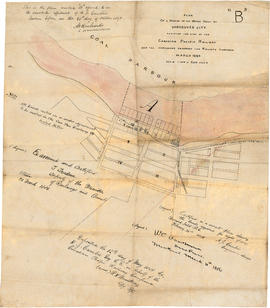
Plan of a portion of the water front of Vancouver city
Part of City of Vancouver Archives technical and cartographic drawing collection
Item is a tracing of a map showing the Vancouver waterfront between Granville and Carrall streets. The original map contains a number of attestations which have been traced: by W.C. Van Horne (Mar. 11, 1886); H.J. Cambie, Engineer in charge (Feb. 22, 1886); T. Trudeau, Deputy Minister of Railways (31 Mar. 1886); and Land Registry office (12 May 1886). The Tracing was made from a copy submitted as an appendix to an affadvit May 28, 1891.

Map showing location of single women receiving assistance by mail
Part of City of Vancouver Archives technical and cartographic drawing collection
Item is a map showing the City of Vancouver covered with annotations to represent the numbers of women in particular areas receiving assistance by mail. Map is a copy of the original and it is not possible to determine the original colour coding.
Vancouver (B.C.). Engineering Services

Map showing location of single men receiving assistance by mail
Part of City of Vancouver Archives technical and cartographic drawing collection
Item is a map showing the City of Vancouver covered with annotations to represent the numbers of men in particular areas receiving assistance by mail. Map is a copy of the original and it is not possible to determine the original colour coding.
Vancouver (B.C.). Engineering Services

Vancouver downtown property map
Part of City of Vancouver Archives technical and cartographic drawing collection
Item consists of a planning map depicting every building between Main Street and Stanley Park north of False Creek, showing the address, name (if a commercial building), number of floors, and type of use (commercial, apartments, vacant, etc. ). The map may be based on a City of Vancouver Planning Department map, partially re-purposed and published by Colliers Macaulay Nicholls.

Map of portion New Westminster District
Part of City of Vancouver Archives technical and cartographic drawing collection
Item is a heavily-amended copy of a map illustrating intended land settlement and subdivision in 1877 in the future sites of Vancouver, Burnaby and the North Shore, from an area bordering on English Bay to an area bordering on North Arm. Also shown are bodies of water, Hastings & Granville Road, and the settlements of Hastings and Granville. Annotations by J.S. Matthews in 1954 made on the copy are tracings in white pen and darkening the background to improve the copy.

Index to 400 ft. scale section maps, City of Vancouver, British Columbia
Part of City of Vancouver Archives technical and cartographic drawing collection
Item is an index map for the sections which comprise the sectional map.
Vancouver (B.C.). Engineering Services
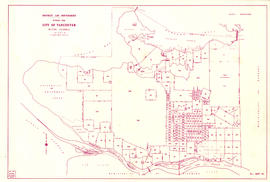
District lot boundaries with the City of Vancouver, British Columbia
Part of City of Vancouver Archives technical and cartographic drawing collection
Item is a map of the City of Vancouver showing district lot boundaries.
Vancouver (B.C.). Engineering Services
Map of City of Vancouver, British Columbia
Part of City of Vancouver Archives technical and cartographic drawing collection
Item is a map annotated to show the Naval Reserve at Jericho and its distance, in chains, to Granville Island. Base map shows streets, parks, golf courses, and distances from City Hall.
Vancouver (B.C.). Engineer's Office

Part of City of Vancouver Archives technical and cartographic drawing collection
Item is a tracing of a map. The tracing shows city blocks, tramways, and railways in Vancouver. The map includes three illustrations, entitled: A glimpse of Cordova Street; In Stanley Park; View of city from Fairview.
Stuart, Allan K.

Rezoning application map (Point Grey Road)
Part of City of Vancouver Archives technical and cartographic drawing collection
Item is a map that would have been created to accompany an application for re-zoning for Block 235 D.L. 538 and water lots 5834, 5601 and 5600. It appears that this application failed, as no amendment to By-law 3575 for these properties has been found.
Vancouver (B.C.). Planning Department
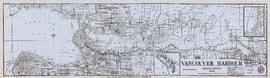
Vancouver Harbour, British Columbia, 1945
Part of City of Vancouver Archives technical and cartographic drawing collection
Item is a nautical chart showing English Bay and Burrard Inlet with soundings in feet, anchorages, locations of submarine cables, and ferry lines. Land features include city blocks and district lot numbers. Includes inset maps of the North Arm of Burrard Inlet and Vancouver Island. Note at the bottom of map states, "Not to be used for navigational purposes."

Plan of the City of Vancouver. Western Terminus of the Canadian Pacific Railway
Part of City of Vancouver Archives technical and cartographic drawing collection
Item is a map shows Vancouver at the end of the 19th century and includes Hastings Townsite. The inset map is an index map showing Vancouver in relation to south-western British Columbia. A shaded area on the index map shows the extent of the C.P.R. land grant.

Vancouver, British Columbia : south-westerly portion, formerly Point Grey : major street plan
Part of City of Vancouver Archives technical and cartographic drawing collection
Item is a map which has been removed from a copy of the report "A plan for the City of Vancouver, British Columbia, including Point Grey and South Vancouver and a general plan of the region", commissioned by the Vancouver Town Planning Commission from the planning consultants Harland Bartholomew & Associates.
The map shows existing and proposed additions to the major street plan in part of the city that is the former Municipality of Point Grey. The map also shows present street widths, lines of vehicles and roadway widths versus proposed street widths, lines of vehicles and roadway widths.
Harland Bartholomew and Associates

Vancouver, British Columbia : northerly portion, former City of Vancouver : major street plan
Part of City of Vancouver Archives technical and cartographic drawing collection
Item is a map which has been removed from a copy of the report "A plan for the City of Vancouver, British Columbia, including Point Grey and South Vancouver and a general plan of the region", commissioned by the Vancouver Town Planning Commission from the planning consultants Harland Bartholomew & Associates.
The map shows the existing and proposed revisions to the major street plan in the northern portion of Vancouver. The map also shows present street widths, lines of vehicles and roadway widths versus proposed street widths, lines of vehicles and roadway widths.
Harland Bartholomew and Associates

Vancouver, British Columbia, south-easterly portion, formerly South Vancouver : major street plan
Part of City of Vancouver Archives technical and cartographic drawing collection
Item is a map which has been removed from a copy of the report "A plan for the City of Vancouver, British Columbia, including Point Grey and South Vancouver and a general plan of the region", commissioned by the Vancouver Town Planning Commission from the planning consultants Harland Bartholomew & Associates.
The map shows major streets of sufficient width, major streets to be widened, new major street connections, present street widths, present lines of vehicles, present roadway widths, proposed street widths, proposed lines of vehicles, proposed roadway widths and pleasure drives in the area of the former Municipality of South Vancouver.
Harland Bartholomew and Associates

General development plan, Exhibition Park, Vancouver, B.C.
Part of City of Vancouver Archives technical and cartographic drawing collection
Item is a map showing the Exhibition Park site, with existing buildings, proposed buildings (immediate program), proposed buildings (future program), building names and parking lot capacities.
Harland Bartholomew and Associates
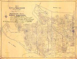
Vancouver civil defense subdivisions
Part of City of Vancouver Archives technical and cartographic drawing collection
Item is a copy of an Engineering Department map which has been annotated to show the City of Vancouver divided into six civil defence subdivisions, labelled A-F.
Vancouver (B.C.). Civil Defence

Map of City of Vancouver, British Columbia
Part of City of Vancouver Archives technical and cartographic drawing collection
Item is a map of Vancouver showing streets, blocks, parks, country clubs and golf courses, as well as distances from City Hall.

Map of City of Vancouver, British Columbia
Part of City of Vancouver Archives technical and cartographic drawing collection
Item is a map of Vancouver showing streets, blocks, parks, country clubs and golf courses, as well as distances from City Hall. Certain areas on the map are circled in red and the date of development, 1886-1912, is indicated. Some areas are shaded in green, but there is no indication on the map as to why this is the case.

Plan showing polling divisions, City of Vancouver, B.C.
Part of City of Vancouver Archives technical and cartographic drawing collection
Item is a map shows polling divisions and poll station locations within each division, created as a Schedule to by-law no. 2434, which defined polling division boundaries.
Vancouver (B.C.). Engineer's Office

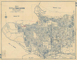
Plan of the City of Vancouver, British Columbia
Part of City of Vancouver Archives technical and cartographic drawing collection
Item is a map showing District Lots, blocks and lots for the City of Vancouver with an inset of an index plan. The sheet also includes an index plan showing the Lower Mainland north of 16th Avenue, and an inset map of Stanley Park.

Schedule "A" : polling districts, City of Vancouver
Part of City of Vancouver Archives technical and cartographic drawing collection
Item is a sheet with four maps created to accompany by-law 3631, defining revisions to polling district boundaries. The by-law revises by-law 3256.
Vancouver (B.C.). Engineer's Office

City of Vancouver, British Columbia
Part of City of Vancouver Archives technical and cartographic drawing collection
Item is a map which shows city streets and blocks. The map also notes the location of parks, golf courses and transportation infrastructure.

Tourist guide map of Vancouver City and park
Part of City of Vancouver Archives technical and cartographic drawing collection
Item is a map shows city streets for downtown, Fairview and Mount Pleasant, and major civic, municipal and industrial buildings, as well as "electric street railways shown in red." An inset map shows the roads and trails of Stanley Park. The map is annotated with green pencil shading "signifies where houses are" and blue shading indicates areas where it "is almost entirely vacant land - small trees."

Sheet W : Fraser River to French Street and Fifty-ninth Avenue to Seventy-first Avenue
Part of City of Vancouver Archives technical and cartographic drawing collection
Item is a section showing the area from the Fraser River to French Street and Fifty-ninth Avenue to Seventy-first Avenue. Includes streets, roads, blocks, lots, legal descriptions, parks and golf courses.
Vancouver (B.C.). Office of the City Engineer

Plan of the City of Vancouver, British Columbia
Part of City of Vancouver Archives technical and cartographic drawing collection
Item is a partial copy of a map of Vancouver, showing only the western portion of the pre-1929 city.

Index plan of provincial government lands to be sold at auction at Vancouver B.C. November 20, 1906
Part of City of Vancouver Archives technical and cartographic drawing collection
Item is a map showing lots owned by the provincial government to be sold at auction. Lots are located in North Vancouver, Vancouver, South Vancouver, Hastings Townsite and Burnaby.

The Municipality of South Vancouver
Part of City of Vancouver Archives technical and cartographic drawing collection
Item is a map depicting the Municipality of South Vancouver. The map has been annotated to indicate some of the routes of BC Electric Railway street car lines and surveyed extensions.

Part of City of Vancouver Archives technical and cartographic drawing collection
Item is an illustrated map of Vancouver and the North Shore. Locations on the map are given in the original native languages. A legend provides translations of the location names. The map is illustrated with images of animals, trees and a large image of a totem pole.
Jessiman, Mary

Part of City of Vancouver Archives technical and cartographic drawing collection
![Vancouver, B.C. Plan showing location of water pipes, hydrants, etc. [Hastings Park area]](/uploads/r/null/0/c/0c5e2bf211ef2e6dfd7a025d620f00d0e64653f3c8080a7e2b3699fffe60e5a3/22c75a7d-7301-4578-8f71-378ca61a6b27-MAP72_142.jpg)
Vancouver, B.C. Plan showing location of water pipes, hydrants, etc. [Hastings Park area]
Part of City of Vancouver Archives technical and cartographic drawing collection
Map is a plan showing the location of water pipes and hydrants in the area between William Street and Burrard Inlet, and Garden Drive and Boundary Road. Pipes and hydrants are indicated in red, with some additional annotations made in black ink. Map includes Hastings Park and the proposed Second Narrows Bridge.
Vancouver (B.C.). Water Works Department
![Vancouver, B.C. Plan showing location of water pipes, hydrants, etc. [Grandview]](/uploads/r/null/8/8/88632d271347b57b818fde723ce9ea599c725a5190b4fb2bbb11e5f98e3809ae/3657fbb2-2cf9-4d03-b885-3836ab221252-MAP72_142.jpg)
Vancouver, B.C. Plan showing location of water pipes, hydrants, etc. [Grandview]
Part of City of Vancouver Archives technical and cartographic drawing collection
Item is a map showing the location of water pipes and hydrants for the years 1905 to 1909 in the area from Graveley Street to 15th Avenue and Victoria Drive to Hastings Townsite (D.L. 264A and D.L. 195). Pipes and hydrants are shown in various coloured inks to indicate date of installation.
Vancouver (B.C.). Water Works Department
![Vancouver, B.C. Plan showing location of water pipes, hydrants, etc. [South Granville]](/uploads/r/null/e/a/eadb6d7351a77ac5788832abd83754cbe2966049728712aa7773bf6f2a74ff34/819e5ce5-621b-43ff-b1f5-f3bf4cac0562-MAP72_142.jpg)
Vancouver, B.C. Plan showing location of water pipes, hydrants, etc. [South Granville]
Part of City of Vancouver Archives technical and cartographic drawing collection
Item is a map showing the location of water pipes and hydrants in the area between Granville Street and Oak Street, and 11th Avenue and 15th Avenue (D.L. 526). Pipes and hydrants are indicated in red and brown ink.
Vancouver (B.C.). Water Works Department
![Vancouver, B.C. Plan showing location of water pipes, hydrants, etc. [Hastings Sunrise]](/uploads/r/null/b/c/bc8cb6a6f5ac5df0dd88a65e8a29ecceca242bde2c1b605533ad17eb835cc450/b2741291-73c5-4a98-9f41-db7fdc46fe83-MAP72_142.jpg)
Vancouver, B.C. Plan showing location of water pipes, hydrants, etc. [Hastings Sunrise]
Part of City of Vancouver Archives technical and cartographic drawing collection
Item is a map showing the location of water pipes and hydrants for the area from Kamloops Street to Kootenay Street and Fourteenth Avenue to Government Road (29th Avenue). Pipes and hydrants are indicated in red ink. Base map is a portion of a larger map.
Vancouver (B.C.). Water Works Department
![Vancouver, B.C. Plan showing location of water pipes, hydrants, etc. [Burrard Street to Gore Avenue]](/uploads/r/null/7/7/7797d041e72dece35da90eab6733a9db50a0b2115ad816578d3633a58bf31761/ebc0f54a-c23a-425c-816d-1dd268a2e4e7-MAP72_142.jpg)
Vancouver, B.C. Plan showing location of water pipes, hydrants, etc. [Burrard Street to Gore Avenue]
Part of City of Vancouver Archives technical and cartographic drawing collection
Item is a map showing the location of water pipes and hydrants for the area Burrard Street to Gore Avenue (D.L. 541). Pipes and hydrants are shown in various coloured inks to indicate installation date.
Vancouver (B.C.). Water Works Department

Part of City of Vancouver Archives technical and cartographic drawing collection
Item is a map showing the location of water pipes and hydrants for the area from Victoria Drive to False Creek to Prince Edward Street to 16th Avenue (D.L. 264A). Pipes and hydrants are shown in various coloured inks to indicate date of installation.
Vancouver (B.C.). Water Works Department
![Vancouver, B.C. Plan showing location of water pipes, hydrants, etc. [West End]](/uploads/r/null/0/5/05354f71931ba85b05864a2adeb3580a6365ddf962e5084f0bb51c68608364a0/3f57f512-bd27-404e-a332-e0881405c2ac-MAP72_142.jpg)
Vancouver, B.C. Plan showing location of water pipes, hydrants, etc. [West End]
Part of City of Vancouver Archives technical and cartographic drawing collection
Item is a map showing the location of water pipes and hydrants for the West End west of Burrard Street. Pipes and hydrants are shown in various coloured inks to indicate date of installation. Annotations have been added to a base map which is a portion of a larger map.
Vancouver (B.C.). Water Works Department
![Vancouver, B.C. Plan showing location of water pipes, hydrants, etc. [Fairview slopes]](/uploads/r/null/6/9/69e0d6904facfa2a814069c15122fba46fc4d8077bff76402e95484a4b13d4d8/313b8940-1e98-45d4-b077-abe0f6bee66a-MAP72_142.jpg)
Vancouver, B.C. Plan showing location of water pipes, hydrants, etc. [Fairview slopes]
Part of City of Vancouver Archives technical and cartographic drawing collection
Item is a map showing the location of water pipes and hydrants for the area bounded by Scotia Street, False Creek, Spruce Street and Tenth Avenue (D.L. 526, D.L. 302 and D.L. 200). Block 6 in D.L. 200 was covered by an overlay depicting a later sub-division. Pipes and hydrants are shown in various coloured inks to indicate installation date. Annotations have been drawn on a base map that was part of a larger map.
Vancouver (B.C.). Water Works Department

Part of City of Vancouver Archives technical and cartographic drawing collection
Item is a map showing the location of water pipes and hydrants for the Downtown Eastide and Strathcona west of McLean Drive (D.L. 181, D.L. 182B, D.L. 196). The sheet also includes an inset map of the area bounded by Columbia Street, Alexander Street, Westminster Avenue and Powell Street. Pipes and hydrants are shown in various coloured inks to indicate date of installation.
Vancouver (B.C.). Water Works Department