
- AM1594-: MAP 820-: LEG1279.3
- Part
- [ca. 1945]
Part of City of Vancouver Archives technical and cartographic drawing collection
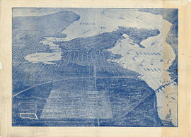
Part contains a street map of Vancouver showing streets, block numbers, bus routes, railway lines, boundaries, private roads and hospitals. The map includes a dial (a numbered circle, a paper indicator, a grid of block numbers and a street index used to find locations in Vancouver). A small inset shows the streets surrounding Queen Elizabeth Park, which are obscured on the main map where the indicator is attached.


![Section 1 [Coal Harbour to Jervis Street]](/uploads/r/null/9/e/9/9e9001a91f4548dd7acb5cf68e9748a8fa0f3d8a10ad9a1235983466dfcc5e1f/d062ae77-a147-4ff8-8a2f-805b659ba7b3-1972-581_142.jpg)
![Section 2 [Jervis Street to Granville Street]](/uploads/r/null/c/f/5/cf5684518fb1cdac0f2d643c89acc078a47fe51a6a1896caf8fcfaf23999a562/c5097ebd-7d02-4ddb-be5e-d0f2658f2849-1972-581_142.jpg)
![Section 3 [Granville Street to Abbott Street]](/uploads/r/null/f/7/c/f7c18e536d617ec84d3c777f7d3bc02b98868d606842132c28166caaaa2dac3d/7e715850-e92f-48ba-bbc7-3678c5a832df-1972-581_142.jpg)
![Section 4 [Abbott Street to Gore Avenue]](/uploads/r/null/d/0/b/d0bdb5bfbb8ea9ebfe40ab12d3166035d9041c0874b44ccbcf0feaf7d343e90d/3d33023b-e416-4a39-b51c-f201b58c1e2c-1972-581_142.jpg)
![Section 6 [Heatley Avenue to Raymur Avenue]](/uploads/r/null/3/a/0/3a00a7d7ff2433b00b59b0d575006a89ff1e36eea4ecb961d585d3702308874e/61c58478-fbdc-4b03-b27d-4c69089913cd-1972-581_142.jpg)
![Section 5 [Gore Avenue to Heatley Avenue]](/uploads/r/null/c/a/9/ca9447df558507296e13d910ed22dcef00b730757d8104a6fdbd5d4e2955a8e1/f669a13d-c71c-4b3a-904d-555f84e054a3-1972-581_142.jpg)
![Section 7 [Raymur Avenue to McLean Drive]](/uploads/r/null/6/6/9/669640404bae29e74b38e879b94454a054f0417ed40580a028e0db5b976a2e80/614de88a-1a33-4127-8bdf-f328f3cd4e22-1972-581_142.jpg)
![Section 9 [Salisbury Drive to McGill and Wall Streets]](/uploads/r/null/2/c/a/2ca00124652bd05f6e2ba7a38be0913c343f9df3ba7b70bb934ceb836de2fa89/dd14b8fd-0710-4ff6-9a02-2a79e289941f-1972-581_142.jpg)
![Section 8 [McLean Drive to Salisbury Drive]](/uploads/r/null/9/1/c/91cb699e74dcee955f380f79208650cd638e651fcce20dbaf91e0f6fd7309854/2dcab9c8-db56-41e3-934c-91dbdfccf6f8-1972-581_142.jpg)


![Plate A [Index map of Vancouver - western portion]](/uploads/r/null/0/d/0/0d022ba039f0508a397a4d35450b667671f0ef36fd388f800f51681434d2a2a9/795dc4f4-e794-4288-880d-6bd4de616417-1974-100_142.jpg)
![Plate B [Index map of Vancouver - central portion]](/uploads/r/null/3/3/6/336c664924c5e585334207b2fe0914ca7325cbf0099b84ef15ac10c18e7792d9/5b4fc691-1bcd-4a8e-864a-16ebbe062389-1974-100_142.jpg)
![Plate 101 [Alberta Street to False Creek to Bridge Street to Fifth Avenue]](/uploads/r/null/3/a/c/3ac4671c467690486217deca7d5b3609b605b6fc542b79fb134372abed97a952/1e879c50-27f7-4e55-8d48-ae8d72b27441-1974-100_142.jpg)
![Plate C [Index map of Vancouver - eastern portion]](/uploads/r/null/8/b/6/8b6eb59bc4a531f865d7df228919b13fa3b1b60a5776762d5d955cc44c5b8db5/83254bae-fa92-4283-82e4-0a09c85c0b9e-1974-100_142.jpg)
![Plate 102 [Front Street to False Creek to Cambie Street Bridge]](/uploads/r/null/2/3/4/23495fedf0cfd0840f946ff51151c2d620ac4381afedbd39cc496162211c108a/798a5687-2c56-4add-bf27-5adb8e27ebeb-1974-100_142.jpg)
![Plate 103 [Manitoba Street to False Creek to Dufferin Street]](/uploads/r/null/0/8/7/0878dcb1525256aa0f6a2ddfe63ea87046dd130caf68b3d7632593fb9d0e805f/b9950050-5631-4c4c-ac19-d2f7d1e8440a-1974-100_142.jpg)
![Plate 105 [Front Street to False Creek to Quebec Street to Dufferin Street]](/uploads/r/null/a/f/b/afbb9be25514350d408eefa5865173e3a489ecdb6752d6b3096564052b234ca4/8c126ea6-16bb-4f0b-8131-a16f2a686d95-1974-100_142.jpg)
![Plate 104 [Quebec Street to False Creek to Manitoba Street to Dufferin Street]](/uploads/r/null/b/3/b/b3b42c0352bed859e94ea30004ddb12475eea99c16a153542be22e644023b5ac/98b44bb6-b7b2-4f4c-aa2e-1d090030146e-1974-100_142.jpg)
![Plate 106 [Manitoba Street to Dufferin Street to Alberta Street to Fifth Avenue]](/uploads/r/null/a/2/8/a288bcdc881a84d269c058cb38c117c43ef34c68d4a36dd1ffa72bfc2a46ba60/2d5baff6-456c-4406-9faf-fdd562e492b0-1974-100_142.jpg)
![Plate 107 [Quebec Street to Dufferin Street to Manitoba Street to Fifth Avenue]](/uploads/r/null/0/d/7/0d79d0f2e59b2acf6f0b094b86112948aced989bd8c13eb8f8ac17f5cb05a1fd/b74906fe-c1a9-49b1-8bc5-37b4141108f6-1974-100_142.jpg)
![Plate 108 [Scotia Street to Front/Dufferin Streets to Quebec Street to Fifth Avenue]](/uploads/r/null/5/4/6/54625ed1d1a99824d0a91f9897950dc4d1691ce8f7fae7be8086e768e671ef0e/5da48b46-8a62-40b9-9992-0fcbe4e8b491-1974-100_142.jpg)