
Sectional map and street directory of Vancouver, British Columbia : street directory
- AM1519-: PAM Und. 500-: LEG1319.370
- Part
- [ca. 1943]
239 results with digital objects Show results with digital objects
Sectional map and street directory of Vancouver, British Columbia : street directory

Sectional map and street directory of Vancouver, British Columbia : street directory


Sectional map and street directory of Vancouver, British Columbia : North Vancouver and district


Sectional map and street directory of Vancouver, British Columbia : map of Maillardville


Sectional map and street directory of Vancouver, British Columbia : list of churches

Sectional map and street directory of Vancouver, British Columbia : list of churches continued

Sectional map and street directory of Vancouver, British Columbia : list of churches continued

Sectional map and street directory of Vancouver, British Columbia : list of Vancouver city schools


Sectional map and street directory of Vancouver, British Columbia : list of busses

Sectional map and street directory of Vancouver, British Columbia : Blue Ribbon advertisement

Tourists' map of Greater Vancouver : map of downtown Vancouver and map of New Westminster
Part contains a map of Downtown Vancouver, a map of the downtown section of New Westminster, and information for tourists including interesting facts about Vancouver. Maps show principal street names and some building names.
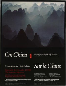
On China : Photographs by Hiroji Kubta
Item is a poster advertising an exhibition of photographs by photographer Hiroji Kubta at the Museum of Vancouver.
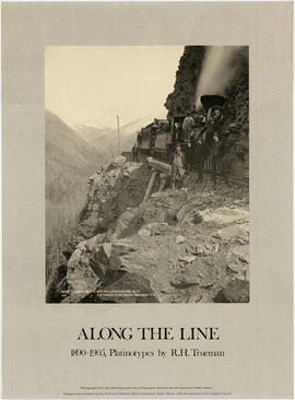
Along the line : 1890-1905 Platinotypes by R.H. Trueman
Item is a poster advertising an exhibition of photographs by photographer R.H. Trueman from the holdings of the City of Vancouver Archives and Vancouver Public Library, possibly at the Whyte Museum of the Canadian Rockies.

Male Voice Choir of Nanaimo, B.C. Winners of the Eisteddfod Prize, Vancouver, May 22, 1912
Part is a photograph. Group portrait of Male Voice Choir of Nanaimo, B.C.

An auction sale of government lands
Item is a poster announcing an auction sale of provincial government lands situated in the Municipality of Point Grey at Dominion Hall, 339 Pender Street West. The auction encompassed "the ten blocks known as Blocks 182, 193, 194, 205, 206, 217, 218, 229, 230 and 233 - District Lots 176 and 538." The ten blocks for sale are shown at the bottom of poster and the map shows they are located between Highbury Street and Alma Road, and 10th Avenue to Point Grey Road. Map in upper right corner of poster shows the City of Vancouver from 27th Avenue to 13th Street (North Vancouver), and Esmono Avenue to just past Tolmie Street.

Municipality of Point Grey second annual dinner of the staff of the engineering department
![Jubilee beer [beer bottle label]](/uploads/r/null/6/a/6a92b1fc9223065733a0f782bef4edd7508937954c89721c2c4f45c6b05c5bae/cf31bc4b-040f-4d7b-a87a-a181dfc6bdf1-A63495_142.jpg)
Jubilee beer [beer bottle label]

Item is a map showing directions to the Vancouver Visitor's Bureau. Map shows routes from the airport, the Black Ball ferry, Highway No. 7, Highway No. 99 and Highway No. 1. Map contains an inset map that zooms into Downtown Vancouver to show street names around the Visitor's Bureau.

Point Grey Golf & Country Club : The Clubhouse 1922-1960
item is a halftone print made from a photograph of the clubhouse.

Here's a souvenir story-map of your trip through Canada's famous Gulf Islands
Item is a placemat showing a map of the ferry route between Swartz Bay and Tsawwassen. Placemat includes historical information about locations shown on map.
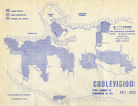
Cablevision : Vancouver, B.C., Canada
Item is a map showing Cablevision service areas from Drummond Street to Stanley Park to Willingdon Avenue to S.W. Marine Drive. Map contains legend showing "current services," "under construction," and "December, 1964, service" areas.

Issued as vol. 3, no. 1 of Waters, the journal of the Vancouver Aquarium. "Map shows the natural drainage of Vancouver, as it was before the City was built. Based on old maps, Archival records and interviews with pioneers, it continually changes as additional sources of information emerge or as people dig new holes in the ground.". Map shows: "original shore line", "rivers and streams", and "educated guess of waterways".

Vancouver heritage conservation program
For information on the program write City of Vancouver Planning Department. 1886-1986. Oversize poster.
![Enchanting [poster for a Vancouver Centennial project, 1986]](/uploads/r/null/4/f/d/4fd02b2ead3686e1f46be7f1a3fe325d2a38acdfa3773360885a00fee5a3c58c/85921edd-4cbf-4e98-a0ff-ac21801990f1-PAM1986-118_142.jpg)
Enchanting [poster for a Vancouver Centennial project, 1986]
At Pacific Centre, Castle Vancouver, a 1986 centennial project, open daily. Poster.

Vancouver Centennial 1886-1986
Item is a poster featuring a painting by Hugh Ricks of an otter.
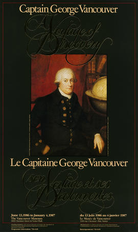
Poster for exhibition at Vancouver Museum, June 13, 1986 to January 4, 1987 on Captain George Vancouver, in celebration of Vancouver Centennial
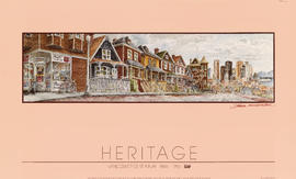
Heritage : Vancouver Centennial 1886-1986
Item is a poster featuring a painting by Michael Kluckner of a Vancouver streetscape filled with heritage houses.

Yesterday, gateway to the Pacific. Today, crossroads of the world. With compliments of the Honourable Marcel Masse, in commemoration of the Vancouver Centennial. Poster - plan of the city of Vancouver, western terminus of the Canadian Pacific Railway 1886

Downtown Vancouver Association historical trek: map
Downtown Vancouver Association historical trek: key
Part is the key to the walking tour on the other side of the sheet. Tour highlights are numbered and named.

Item is a poster containing information about the development of a regional concept and plan for the Lower Mainland. Poster is divided into four text boxes entitled: "The region: today and tomorrow", "A concept: how the region should develop", "Two basic principles of development", and "The first step: the regional plan." The poster contains a diagram showing the concept for development, a series of cities linked by a freeway network. The poster also contains a map showing different areas in the proposed regional plan. Map contains a color coded legend with the following categories: established urban, developing urban, small community, major industrial, acreage, upland farm, floodplain farm, special development, reserve, secured park, and potential park.