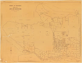
Plan of North Shore, Burrard Inlet between Queensbury and Harbour Avenue
- AM1594-MAP 1195-: LEG1319.525
- Item
- [ca. 1925]-Aug. 1956
Part of City of Vancouver Archives technical and cartographic drawing collection
1440 results with digital objects Show results with digital objects
Plan of North Shore, Burrard Inlet between Queensbury and Harbour Avenue
Part of City of Vancouver Archives technical and cartographic drawing collection
Plan of North Shore, Burrard Inlet between Rogers Avenue and Queensbury Avenue
Part of City of Vancouver Archives technical and cartographic drawing collection
Plan of North Shore, Burrard Inlet between Fell Avenue and St. Andrews
Part of City of Vancouver Archives technical and cartographic drawing collection
Plan of North Shore, Burrard Inlet between Garden Avenue and Fell Avenue
Part of City of Vancouver Archives technical and cartographic drawing collection
Plan of North Shore, Burrard Inlet at First Narrows (Lion's Gate)
Part of City of Vancouver Archives technical and cartographic drawing collection
[Plan of] English Bay, First Narrows
Part of City of Vancouver Archives technical and cartographic drawing collection
[Plan of] English Bay, West Vancouver
Part of City of Vancouver Archives technical and cartographic drawing collection
Plan of South Shore, English Bay between Fir and Trafalgar Streets
Part of City of Vancouver Archives technical and cartographic drawing collection
[Plan of] False Creek, Westerly Portion and Granville Island
Part of City of Vancouver Archives technical and cartographic drawing collection
Part of City of Vancouver Archives technical and cartographic drawing collection
Part of City of Vancouver Archives technical and cartographic drawing collection
[Plan of] English Bay, Cardero Street, Stanley Park
Part of City of Vancouver Archives technical and cartographic drawing collection
[Plan of] English Bay, Stanley Park
Part of City of Vancouver Archives technical and cartographic drawing collection
Plan of South Shore, Brockton Point, Stanley Park
Part of City of Vancouver Archives technical and cartographic drawing collection
Part of City of Vancouver Archives technical and cartographic drawing collection
Part is the inner side of the cover, in which the map was attached map was folded. The page lists dancehalls and licensed hotels in the City of Vancouver.
With compliments and greetings of the management and staff of the Yale Hotel and Yale Gardens
Part of City of Vancouver Archives technical and cartographic drawing collection
Part is the outer side of the cover, in which the map was attached map was folded.
Part of City of Vancouver Archives technical and cartographic drawing collection
Part is the enclosed tourist map of Vancouver, including a street index. Map contains a dial which denotes distance from the Yale Hotel.
Plan of Block 52 D.L. 541 City of Vancouver, showing site of Hotel Vancouver & other buildings
Part of City of Vancouver Archives technical and cartographic drawing collection
Item is a map of the block, annotated with square footages of properties, calculations of land values. The map depicted the Hotel Vancouver, Granville Mansions, Ogden Apartments and first Orpheum Theatre.
Kitsilano and the Municipality of Point Grey
Part of City of Vancouver Archives technical and cartographic drawing collection
Item is a map showing building lots and block numbers in Kitsilano and the Municipality of Point Grey, from English Bay in the north to Marine Drive in the south and from Granville Street in the east to Blanca in the west.

The Estate of Joseph Martin, K.C., MP
Part of City of Vancouver Archives technical and cartographic drawing collection
Part is the front side of the fold-out brochure; it includes promotional information about the estate, Vancouver, the climate, economy, land speculation in the city.
![Plate 11: Downtown [Homer Street - Georgia Street - Thurlow Street - Burnaby Street/Drake Street]](/uploads/r/null/5/b/d/5bdf92b6d2c774df0db66b41942f3eacb7f3ac265aeefeac99ba2fe6be2377b8/42419aa4-f47a-47ec-870b-3fdab1496d88-MAP342a_142.jpg)
Plate 11: Downtown [Homer Street - Georgia Street - Thurlow Street - Burnaby Street/Drake Street]
Part of City of Vancouver Archives technical and cartographic drawing collection
Item is a map depicting an area bounded by the following streets: Homer Street (west side only) to Georgia Street (south side only) to Thurlow Street (east side only) to Burnaby Street (north side only) and Drake Street (north side only).
Part of City of Vancouver Archives technical and cartographic drawing collection
File consists of a booklet of maps advertising the sale of lots in the British Properties development in West Vancouver, B.C. Maps show lot dimensions and purchase price (some lots already listed as sold).

Part of City of Vancouver Archives technical and cartographic drawing collection
Map shows Vancouver from West Boulevard to Boundary Road and from Burrard Inlet to the Fraser River. A portion of North Vancouver is also shown. Streets, parks, schools and golf courses are identified. Map joins with MAP 575 to create a complete map of the City of Vancouver.

Plate 128 Queensborough - north-east
Part of City of Vancouver Archives technical and cartographic drawing collection

Plate 127 Queensborough - north-west
Part of City of Vancouver Archives technical and cartographic drawing collection

Plate 126 Queensborough - south-east
Part of City of Vancouver Archives technical and cartographic drawing collection

Plate 125 Queensborough - south-west
Part of City of Vancouver Archives technical and cartographic drawing collection
![Plate 124 [B.C. Penitentiary grounds to Queens Avenue to Sixth Street to Fraser River]](/uploads/r/null/d/6/1/d6109bdd8c80b7d668876a803cd92924e7a854073c637f53db4b2c4f2f56e7dd/f8d97cae-19cc-470a-868c-534f137994b1-1972-472_142.jpg)
Plate 124 [B.C. Penitentiary grounds to Queens Avenue to Sixth Street to Fraser River]
Part of City of Vancouver Archives technical and cartographic drawing collection
![Plate 123 [Sixth Street to Queens Avenue to eastern tips of Poplar and Lulu Islands to Fraser River]](/uploads/r/null/9/6/d/96d1122e04715f2f5792c19254f6b90991bd8c8f67f1c7becfcc31e30d3fbca4/a6cd188b-876a-455e-976e-285546a198db-1972-472_142.jpg)
Plate 123 [Sixth Street to Queens Avenue to eastern tips of Poplar and Lulu Islands to Fraser River]
Part of City of Vancouver Archives technical and cartographic drawing collection
![Plate 122 [Brunette River to Brunette Street to S.B. III Block 5 to Fraser River]](/uploads/r/null/1/b/5/1b59e8167ff1f1ff2d6e31874f106bae417d748922ed50d678f528ec9ec0e187/0abdbdc1-6755-45b1-aefc-0f6dd819227c-1972-472_142.jpg)
Plate 122 [Brunette River to Brunette Street to S.B. III Block 5 to Fraser River]
Part of City of Vancouver Archives technical and cartographic drawing collection
![Plate 121 [Keary Street to Sixth Avenue to Second Street to Park Row/Fraser River]](/uploads/r/null/e/0/b/e0b9110e611fca8e7037073a608b76e7d8623e29f738c47ba3234626357a78c4/da4cc06d-e15e-47b9-8187-683773fb2ef5-1972-472_142.jpg)
Plate 121 [Keary Street to Sixth Avenue to Second Street to Park Row/Fraser River]
Part of City of Vancouver Archives technical and cartographic drawing collection
![Plate 120 [Second Street to Sixth Avenue to Twelfth Street to Queens Avenue]](/uploads/r/null/5/5/c/55c9677679407ee3ed1945edde4c9075d95bd4718a26b039ac09364740c4d69a/d6480416-ce8f-4c85-9e61-c26d7aab755f-1972-472_142.jpg)
Plate 120 [Second Street to Sixth Avenue to Twelfth Street to Queens Avenue]
Part of City of Vancouver Archives technical and cartographic drawing collection
![Plate 119 [Twelfth Street to Sixth Avenue to Twentieth Street/Lulu Island to Queens Avenue]](/uploads/r/null/7/c/5/7c5b58a5a6cc6d172d2c03c80829cda67864964df06d73df2acf92a075f3ac61/14e5f78e-0f29-4094-a1f1-0e18e3e413de-1972-472_142.jpg)
Plate 119 [Twelfth Street to Sixth Avenue to Twentieth Street/Lulu Island to Queens Avenue]
Part of City of Vancouver Archives technical and cartographic drawing collection
![Plate 118 [Brunette River to Tenth Avenue to Langley/School/Keary Streets to Brunette Street]](/uploads/r/null/1/2/c/12c40d6d14f873e070ca2b0a5bfe05f2d1b13bcaf1775c8dc357e7ca81a55dda/1f12f0be-27cc-46e2-a722-0a8c209f762c-1972-472_142.jpg)
Plate 118 [Brunette River to Tenth Avenue to Langley/School/Keary Streets to Brunette Street]
Part of City of Vancouver Archives technical and cartographic drawing collection
![Plate 117 [Richmond/Sherbrooke/Langley Streets to Tenth Avenue to Second Street to Sixth Avenue]](/uploads/r/null/9/a/e/9ae713ff3ad4c6eb7965c92b08a6609a1355df01d8464e5dc0a4cd5eb347daa3/42ac18ba-9e2f-47a3-9c4d-62090da71521-1972-472_142.jpg)
Plate 117 [Richmond/Sherbrooke/Langley Streets to Tenth Avenue to Second Street to Sixth Avenue]
Part of City of Vancouver Archives technical and cartographic drawing collection
![Plate 116 [Second Street to Tenth Avenue to Twelfth Street to Sixth Avenue]](/uploads/r/null/9/4/a/94a2eaaee6d845d8743ef8c81252057bc025656a77c773dd17e5aa37113b3116/fe7612b5-f7f4-4f6f-b985-a278440f8554-1972-472_142.jpg)
Plate 116 [Second Street to Tenth Avenue to Twelfth Street to Sixth Avenue]
Part of City of Vancouver Archives technical and cartographic drawing collection
![Plate 115 [Twelfth Street to Tenth Avenue to Twentieth Street to Sixth Avenue]](/uploads/r/null/3/e/b/3eb1b1f2663b11b9151d3e22347f7b1fe922789a9a5866f3bf24b29d5b441606/74148ea4-ae2e-43f6-b969-bcdfff9ac71a-1972-472_142.jpg)
Plate 115 [Twelfth Street to Tenth Avenue to Twentieth Street to Sixth Avenue]
Part of City of Vancouver Archives technical and cartographic drawing collection

Index to Streets and Index to Registered Plans
Part of City of Vancouver Archives technical and cartographic drawing collection
![Plate 5: West End [Richards Street - Hastings Street - Thurlow Street - Georgia Street]](/uploads/r/null/6/e/8/6e8029e15299600c6890f41cb1e769ea5f4c8a79c7923ef6e2075a19883197b7/ae297304-5960-4a77-930f-8a2926cc0ee0-MAP342a_142.jpg)
Plate 5: West End [Richards Street - Hastings Street - Thurlow Street - Georgia Street]
Part of City of Vancouver Archives technical and cartographic drawing collection
Item is a map depicting an area bounded by the following streets: Richards Street (west side only) to Hastings Street West (south side only) to Thurlow Street (including 1/2 block adjacent west) to Georgia Street (north side only).

B.C. Electric plan showing bus stops in Vancouver
Part of City of Vancouver Archives technical and cartographic drawing collection
Item contains three maps showing transit routes, bus stops and bus zones in the city of Vancouver. Inset maps show the "Seasonal 'round the park route and stops" in Stanley Park and the "University bus route" in the University Endowment Lands. The main map extends from Smith Avenue to Burrard Inlet to Blanca Street to Marine Drive.

Part of City of Vancouver Archives technical and cartographic drawing collection
Map is a City Engineering Department base map of Vancouver, showing city blocks and Canadian Pacific, Canadian National and Great Northern Railway lines. Parks, golf courses, hospitals, schools, theatres and other structures are identified. "Metric Vancouver" and "Guide Map 15" appear in the bottom right corner of the map.

A preliminary proposal for development of Jericho Park
Part of City of Vancouver Archives technical and cartographic drawing collection
Item shows proposed uses for Jericho Park.

City of Vancouver, British Columbia
Part of City of Vancouver Archives technical and cartographic drawing collection
Item is the western half of a map showing city blocks, transportation infrastructure, recreational facilities, hospitals, schools, theatres and other structures are identified. MAP 1036 is the eastern half of this map.
Vancouver (B.C.). Engineering Services

City of Vancouver, British Columbia
Part of City of Vancouver Archives technical and cartographic drawing collection
Item is the eastern half of a map showing city blocks, transportation infrastructure, recreational facilities, hospitals, schools, theatres and other structures are identified. MAP 1036b is the western half of this map.
Vancouver (B.C.). Engineering Services
District lot boundaries within the City of Vancouver
Part of City of Vancouver Archives technical and cartographic drawing collection

Part of City of Vancouver Archives technical and cartographic drawing collection
Map is a City Engineering Department base map of Vancouver, showing city blocks and Canadian Pacific, Canadian National and Great Northern Railway lines. Parks, golf courses, hospitals, schools, theatres and other structures are identified. "Guide Map 15" appears in the bottom right corner of the map.
![City of Vancouver [park sites June/80]](/uploads/r/null/9/4/9484add7c4684ea3838e4d00ee8add3ecf85d78d5aa8fe2780cae273e59556a5/bd2464d8-2aa9-4501-aba6-8b3f7d130a42-MAP1032_142.jpg)
City of Vancouver [park sites June/80]
Part of City of Vancouver Archives technical and cartographic drawing collection
Map is a City Engineering Department base map of Vancouver, with parks hand-coloured in green. Shows city blocks and Canadian Pacific, Canadian National and Great Northern Railway lines. Golf courses, hospitals, schools, theatres and other structures are identified. "Metric Vancouver" and "Guide Map 15" appear in the bottom right corner of the map.
Part of City of Vancouver Archives technical and cartographic drawing collection
File consists of a display (probably designed for classrooms) of sheets with maps, photographs and information on British Columbia, Canada, the British Empire and the world, including geographical, political, economic and transportation information.

City of Vancouver, British Columbia : co-ordinate street index map 12
Part of City of Vancouver Archives technical and cartographic drawing collection
Map is City Engineering Department base map 149 of the City of Vancouver, showing city blocks, streets and railway lines, as well as the area code co-ordinates assigned by the department. Golf courses, hospitals, schools, theatres and other structures are also identified.

Part of City of Vancouver Archives technical and cartographic drawing collection
Item is a map of Chinatown showing streets, buildings and the number of stories in each building. Includes the area bounded by Taylor Street, Hastings Street, Gore Avenue and Keefer Street. The Provincial Historic Site Boundary, designated February 2, 1971, is drawn on the map.