![Plate 69 [Seymour Street to Helmcken Street to Hornby Street to Drake Street]](/uploads/r/null/3/7/3/37330eff1ce4aa559e86f0d5f0748a4c7ffcf627fc680de72302ebf9a5cb9df4/e0f35d9e-e540-40fb-a87d-026debb71dec-1972-582_142.jpg)
Plate 69 [Seymour Street to Helmcken Street to Hornby Street to Drake Street]
- AM1594-MAP 383-: 1972-582.44
- Item
- 1913-1920
Part of City of Vancouver Archives technical and cartographic drawing collection
68260 results with digital objects Show results with digital objects
Plate 69 [Seymour Street to Helmcken Street to Hornby Street to Drake Street]
Part of City of Vancouver Archives technical and cartographic drawing collection
![Plate 70 [Hamilton Street to Helmcken Street to Seymour Street to Drake Street]](/uploads/r/null/1/8/d/18df5d1b1fa19f409d693219d2bbd713341ea2bfee9af2ec0129894f2bb937d4/0b5f965f-2534-4e51-808c-bf10c982b1f7-1972-582_142.jpg)
Plate 70 [Hamilton Street to Helmcken Street to Seymour Street to Drake Street]
Part of City of Vancouver Archives technical and cartographic drawing collection
![Plate 71 [Canadian Pacific yards between False Creek and Mainland]](/uploads/r/null/e/a/5/ea54b234ef8ac9aac5e3c4b1fb1e4faabeda6dffb6f25fbfc5e7c1e7c4f8216f/1823de1f-abb5-4c9d-8453-fa6979933294-1972-582_142.jpg)
Plate 71 [Canadian Pacific yards between False Creek and Mainland]
Part of City of Vancouver Archives technical and cartographic drawing collection
![Plate 72 [western portion of Beach Avenue]](/uploads/r/null/f/8/7/f87b18d10c1e70a78c4233b6cd2f014445fa13625e7854b728543a93ad9d0ce4/df6e3687-c48e-46ce-9407-344203d4b928-1972-582_142.jpg)
Plate 72 [western portion of Beach Avenue]
Part of City of Vancouver Archives technical and cartographic drawing collection
Part is a map sheet that contains two portions of the map: the first shows the area bounded by Cardero Street, Burnaby Street, and Beach Avenue. The second shows the structures south of Beach Avenue between Thurlow and Burrard Streets.
![Plate 73 [Broughton Street to Burnaby Street to Cardero Street to English Bay]](/uploads/r/null/d/4/d/d4d8344fb9fe03f24afb63b7902e1dc6b26c8aee04e7f37f3fa54e97373668ca/09d385e8-fefb-4816-8f4b-9b7cd544a65d-1972-582_142.jpg)
Plate 73 [Broughton Street to Burnaby Street to Cardero Street to English Bay]
Part of City of Vancouver Archives technical and cartographic drawing collection
![Plate 74 [Bute Street to Burnaby Street to Broughton Street to English Bay]](/uploads/r/null/f/5/a/f5a676b2dbb5bd50aea3d8da4a8b6063dd0432ae34eab9bac9b63e229bc1c6c1/3a4811f6-9929-4b7e-8c1a-00b514e14dd0-1972-582_142.jpg)
Plate 74 [Bute Street to Burnaby Street to Broughton Street to English Bay]
Part of City of Vancouver Archives technical and cartographic drawing collection
![Plate 75 [Thurlow Street to Burnaby Street to Bute Street to False Creek]](/uploads/r/null/4/b/3/4b384cf689e0b4df8b172cc49ab4e4ece27aa86ac06485fa0a1a2561a10904cd/15596025-5e83-4f1c-9d78-cc0f7a05832f-1972-582_142.jpg)
Plate 75 [Thurlow Street to Burnaby Street to Bute Street to False Creek]
Part of City of Vancouver Archives technical and cartographic drawing collection
![Plate 76 [Hornby Street to Burnaby/Drake Streets to Thurlow Street to Beach Avenue]](/uploads/r/null/7/8/2/78299212149d18634009b8f3c6d52450dceb47a2edec212c0f3d07f0e65dd5ad/17a1b420-b0c5-47fe-b4b8-27fe165e9ebf-1972-582_142.jpg)
Plate 76 [Hornby Street to Burnaby/Drake Streets to Thurlow Street to Beach Avenue]
Part of City of Vancouver Archives technical and cartographic drawing collection
![Plate 77 [Seymour Street to Drake Street to Hornby Street to Beach Avenue]](/uploads/r/null/1/e/2/1e2f280818ba9c268a0c3eb37f6c26a3d4e98c44809eaf72f0aa04233923a609/998d7dea-3511-482f-a646-6f87ea4550cd-1972-582_142.jpg)
Plate 77 [Seymour Street to Drake Street to Hornby Street to Beach Avenue]
Part of City of Vancouver Archives technical and cartographic drawing collection
![Plate 78 Canadian Pacific yards to Drake Street to Seymour Street to False Creek]](/uploads/r/null/8/1/c/81c7bdb672f0865def3028cba44861754379b4aa98b7dccf45208a5c0e846567/647f56a7-45c0-47e2-b351-acff47aac926-1972-582_142.jpg)
Plate 78 Canadian Pacific yards to Drake Street to Seymour Street to False Creek]
Part of City of Vancouver Archives technical and cartographic drawing collection
![Plate 79 [Canadian Pacific yards to Beach Avenue to Burrard Street to False Creek]](/uploads/r/null/0/d/b/0db6cb152921eb1a151cba66857c8735fd0fedc15a817296747c66d82f27c657/a98e998d-c944-4c90-866d-fd5d59533397-1972-582_142.jpg)
Plate 79 [Canadian Pacific yards to Beach Avenue to Burrard Street to False Creek]
Part of City of Vancouver Archives technical and cartographic drawing collection
![Plate 80 [Beatty Street to Georgia Street to Hamilton Street to Smithe Street]](/uploads/r/null/d/a/e/daee4ac4066a4e662fb048df52afe5dfc7adc6341a7c055973e46ba1453f8330/505c63b5-b54a-4d4f-bfa1-bce3b08a1f61-1972-582_142.jpg)
Plate 80 [Beatty Street to Georgia Street to Hamilton Street to Smithe Street]
Part of City of Vancouver Archives technical and cartographic drawing collection

Part of City of Vancouver Archives technical and cartographic drawing collection

Part of Robert Twizell fonds
Item is a drawing of proposed oak sounding board over present pulpit for St. Philip's Church. While the specific church is not identified, it is most likely St. Philip's Anglican Church at 3737 West 27th Avenue, Vancouver.
Twizell & Twizell, Architects

Part of Robert Twizell fonds
Item is an architectural drawing of details of the chancel lectern, located in Dunbar Heights United Church, 3525 West 24th Avenue, Vancouver.
Twizell & Twizell, Architects

Part of Robert Twizell fonds
Item is an architectural drawing of oak credence table for St. Paul's church, presumably St. Paul's Anglican Church at 1130 Jervis Street, Vancouver.
Twizell & Twizell, Architects
Part of Robert Twizell fonds
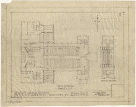
Item is an architectural drawing of St. Giles United Church [305 East 41st Avenue]; the drawing depicts the lay-out of pews and other fittings in the nave and gallery.
Twizell & Twizell, Architects
Part of Bloomfield family fonds
Item is a painting of the City's coat of arms framed in a wooden case created for the City Archives as a memorial to Andrew Linton. Also includes an engraved silver plated plaque.
Blomfield, James
![Plate A [Index map of Vancouver - western portion]](/uploads/r/null/0/d/0/0d022ba039f0508a397a4d35450b667671f0ef36fd388f800f51681434d2a2a9/795dc4f4-e794-4288-880d-6bd4de616417-1974-100_142.jpg)
Plate A [Index map of Vancouver - western portion]
Part of City of Vancouver Archives technical and cartographic drawing collection
![Plate B [Index map of Vancouver - central portion]](/uploads/r/null/3/3/6/336c664924c5e585334207b2fe0914ca7325cbf0099b84ef15ac10c18e7792d9/5b4fc691-1bcd-4a8e-864a-16ebbe062389-1974-100_142.jpg)
Plate B [Index map of Vancouver - central portion]
Part of City of Vancouver Archives technical and cartographic drawing collection
![Plate C [Index map of Vancouver - eastern portion]](/uploads/r/null/8/b/6/8b6eb59bc4a531f865d7df228919b13fa3b1b60a5776762d5d955cc44c5b8db5/83254bae-fa92-4283-82e4-0a09c85c0b9e-1974-100_142.jpg)
Plate C [Index map of Vancouver - eastern portion]
Part of City of Vancouver Archives technical and cartographic drawing collection
![Plate 101 [Alberta Street to False Creek to Bridge Street to Fifth Avenue]](/uploads/r/null/3/a/c/3ac4671c467690486217deca7d5b3609b605b6fc542b79fb134372abed97a952/1e879c50-27f7-4e55-8d48-ae8d72b27441-1974-100_142.jpg)
Plate 101 [Alberta Street to False Creek to Bridge Street to Fifth Avenue]
Part of City of Vancouver Archives technical and cartographic drawing collection
![Plate 102 [Front Street to False Creek to Cambie Street Bridge]](/uploads/r/null/2/3/4/23495fedf0cfd0840f946ff51151c2d620ac4381afedbd39cc496162211c108a/798a5687-2c56-4add-bf27-5adb8e27ebeb-1974-100_142.jpg)
Plate 102 [Front Street to False Creek to Cambie Street Bridge]
Part of City of Vancouver Archives technical and cartographic drawing collection
![Plate 103 [Manitoba Street to False Creek to Dufferin Street]](/uploads/r/null/0/8/7/0878dcb1525256aa0f6a2ddfe63ea87046dd130caf68b3d7632593fb9d0e805f/b9950050-5631-4c4c-ac19-d2f7d1e8440a-1974-100_142.jpg)
Plate 103 [Manitoba Street to False Creek to Dufferin Street]
Part of City of Vancouver Archives technical and cartographic drawing collection
![Plate 104 [Quebec Street to False Creek to Manitoba Street to Dufferin Street]](/uploads/r/null/b/3/b/b3b42c0352bed859e94ea30004ddb12475eea99c16a153542be22e644023b5ac/98b44bb6-b7b2-4f4c-aa2e-1d090030146e-1974-100_142.jpg)
Plate 104 [Quebec Street to False Creek to Manitoba Street to Dufferin Street]
Part of City of Vancouver Archives technical and cartographic drawing collection
![Plate 105 [Front Street to False Creek to Quebec Street to Dufferin Street]](/uploads/r/null/a/f/b/afbb9be25514350d408eefa5865173e3a489ecdb6752d6b3096564052b234ca4/8c126ea6-16bb-4f0b-8131-a16f2a686d95-1974-100_142.jpg)
Plate 105 [Front Street to False Creek to Quebec Street to Dufferin Street]
Part of City of Vancouver Archives technical and cartographic drawing collection
![Plate 106 [Manitoba Street to Dufferin Street to Alberta Street to Fifth Avenue]](/uploads/r/null/a/2/8/a288bcdc881a84d269c058cb38c117c43ef34c68d4a36dd1ffa72bfc2a46ba60/2d5baff6-456c-4406-9faf-fdd562e492b0-1974-100_142.jpg)
Plate 106 [Manitoba Street to Dufferin Street to Alberta Street to Fifth Avenue]
Part of City of Vancouver Archives technical and cartographic drawing collection
![Plate 107 [Quebec Street to Dufferin Street to Manitoba Street to Fifth Avenue]](/uploads/r/null/0/d/7/0d79d0f2e59b2acf6f0b094b86112948aced989bd8c13eb8f8ac17f5cb05a1fd/b74906fe-c1a9-49b1-8bc5-37b4141108f6-1974-100_142.jpg)
Plate 107 [Quebec Street to Dufferin Street to Manitoba Street to Fifth Avenue]
Part of City of Vancouver Archives technical and cartographic drawing collection
![Plate 108 [Scotia Street to Front/Dufferin Streets to Quebec Street to Fifth Avenue]](/uploads/r/null/5/4/6/54625ed1d1a99824d0a91f9897950dc4d1691ce8f7fae7be8086e768e671ef0e/5da48b46-8a62-40b9-9992-0fcbe4e8b491-1974-100_142.jpg)
Plate 108 [Scotia Street to Front/Dufferin Streets to Quebec Street to Fifth Avenue]
Part of City of Vancouver Archives technical and cartographic drawing collection
![Plate 109 [Victoria Drive to False Creek to Scotia Street to Fifth Avenue]](/uploads/r/null/c/f/7/cf796986affb1d4761889c3b98c83be508ab7b762a16dcde3f48354e496a910f/3e0ce046-091f-45fb-b3ec-8ef8d907b4c2-1974-100_142.jpg)
Plate 109 [Victoria Drive to False Creek to Scotia Street to Fifth Avenue]
Part of City of Vancouver Archives technical and cartographic drawing collection
![Plate 110 [Carolina Street to False Creek to Victoria Drive to Seventh Avenue]](/uploads/r/null/9/c/d/9cde1416ae9e7694bef6c49f29ddb6e0e736b4639ac4c5dfd11bc2ba91e0e05e/c91e3418-bc09-4b26-a8c5-2adaccfe4aa1-1974-100_142.jpg)
Plate 110 [Carolina Street to False Creek to Victoria Drive to Seventh Avenue]
Part of City of Vancouver Archives technical and cartographic drawing collection
![Plate 111 [Burns Street to False Creek to Carolina Street to Seventh Avenue]](/uploads/r/null/2/d/2/2d251d7248e7bf038122c9c38701419ecb65debefb060aa248148844edbc39a1/2e6a05ed-365c-42ec-b3ff-64338fcca4d0-1974-100_142.jpg)
Plate 111 [Burns Street to False Creek to Carolina Street to Seventh Avenue]
Part of City of Vancouver Archives technical and cartographic drawing collection
![Plate 112 [Alberta Street to Fifth Avenue to Bridge Street to Eighth Avenue]](/uploads/r/null/7/f/9/7f975ee4ccb3f0a5d9e1476fa7387fafeece721794c61445a846aff9bf0a1bce/4c08bf91-8091-4758-a4c4-2dbb0cc6ca4e-1974-100_142.jpg)
Plate 112 [Alberta Street to Fifth Avenue to Bridge Street to Eighth Avenue]
Part of City of Vancouver Archives technical and cartographic drawing collection
![Plate 113 [Manitoba Street to Fifth Avenue to Alberta Street to Eighth Avenue]](/uploads/r/null/6/7/c/67cdb1d1eab4b07c2b015fc0f90710fa8ae4450274ff5bd6f2998b216902384e/44c3fa3c-b383-463b-9d54-278f6ba758a1-1974-100_142.jpg)
Plate 113 [Manitoba Street to Fifth Avenue to Alberta Street to Eighth Avenue]
Part of City of Vancouver Archives technical and cartographic drawing collection
![Plate 114 [Quebec Street to Fifth Avenue to Manitoba Street to Eighth Avenue]](/uploads/r/null/1/d/a/1da8c667b11d0f463073015a74cdc6f409f2f18733a36abda9afe0b996d9abe6/02c6dfe0-25c2-4696-8ff5-429480c2de74-1974-100_142.jpg)
Plate 114 [Quebec Street to Fifth Avenue to Manitoba Street to Eighth Avenue]
Part of City of Vancouver Archives technical and cartographic drawing collection
![Plate 115 [Scotia Street to Fifth Avenue to Quebec Street to Eighth Avenue]](/uploads/r/null/b/8/6/b86c99928da0cefb46e6dc6e7d9b2f9feb0c5d75b13cbfacf0da89c0e212870c/10e20065-c9ef-41ad-a820-8e3c418d2043-1974-100_142.jpg)
Plate 115 [Scotia Street to Fifth Avenue to Quebec Street to Eighth Avenue]
Part of City of Vancouver Archives technical and cartographic drawing collection
![Plate 116 [Victoria Drive to Dufferin Street/Fifth Avenue to Scotia Street to Eighth Avenue]](/uploads/r/null/a/4/8/a48d7c5927867042c40b8415d5b33492b6ba8385e375aec78a675f2d3859417a/0dac58ba-008b-4d37-8ea2-aabfd1cb96d8-1974-100_142.jpg)
Plate 116 [Victoria Drive to Dufferin Street/Fifth Avenue to Scotia Street to Eighth Avenue]
Part of City of Vancouver Archives technical and cartographic drawing collection
![Plate 117 [Carolina Street to Seventh Avenue to Victoria Drive to Tenth Avenue]](/uploads/r/null/f/0/1/f01e37963864f5231283cc4e6bc7df6cd6d6df44667846c5e69dc6787c623881/1797e915-b1a7-4980-acf1-b42faefa128c-1974-100_142.jpg)
Plate 117 [Carolina Street to Seventh Avenue to Victoria Drive to Tenth Avenue]
Part of City of Vancouver Archives technical and cartographic drawing collection
![Plate 118 [Burns Street to Seventh Avenue to Carolina Street to Tenth Avenue]](/uploads/r/null/1/3/d/13d0f752a2256754eef1871ceaee111678790dfc9ac08ab3515e1d24051659bc/b001c220-4630-4f03-bbd4-e73eaafe8133-1974-100_142.jpg)
Plate 118 [Burns Street to Seventh Avenue to Carolina Street to Tenth Avenue]
Part of City of Vancouver Archives technical and cartographic drawing collection
![Plate 119 [Dock Street to Seventh Avenue to Burns Street to Tenth Avenue]](/uploads/r/null/d/7/c/d7cf9a44b79c3474cf22e547b284ddfb851d469419b4c16364c5bd62aacd6b8a/6ff5b121-a238-4b51-8586-2e9962088a05-1974-100_142.jpg)
Plate 119 [Dock Street to Seventh Avenue to Burns Street to Tenth Avenue]
Part of City of Vancouver Archives technical and cartographic drawing collection
![Plate 120 [Manitoba Street to Eighth Avenue to Alberta Street to Eleventh Avenue]](/uploads/r/null/f/a/6/fa6302e459598f703ec9a4f6d49de458a312194cf71a4d02ffaeb7416336e184/73a06efd-6ff6-4712-86d3-99cef6e5d4f3-1974-100_142.jpg)
Plate 120 [Manitoba Street to Eighth Avenue to Alberta Street to Eleventh Avenue]
Part of City of Vancouver Archives technical and cartographic drawing collection
![Plate 121 [Quebec Street to Eighth Avenue to Manitoba Street to Eleventh Avenue]](/uploads/r/null/a/f/1/af121e25c31c0cfec1192729732131e8c10fc3b73fef80730f442c4b8851d11e/1a24a04e-7d82-4800-96dd-ef72113c34a3-1974-100_142.jpg)
Plate 121 [Quebec Street to Eighth Avenue to Manitoba Street to Eleventh Avenue]
Part of City of Vancouver Archives technical and cartographic drawing collection
![Plate 122 [Scotia Street to Eighth Avenue to Quebec Street to Eleventh Avenue]](/uploads/r/null/8/8/1/881d5dea72196cae5eaf43f70c73e80c2fb405045a4bdf21ca39865bf3017c2a/f99553c0-92f4-46fe-8932-ac6c8ad65532-1974-100_142.jpg)
Plate 122 [Scotia Street to Eighth Avenue to Quebec Street to Eleventh Avenue]
Part of City of Vancouver Archives technical and cartographic drawing collection
![Plate 123 [Victoria Drive to Eigth Avenue to Scotia Street to Eleventh Avenue]](/uploads/r/null/8/7/7/877219ac8c7a9bd7a9f4f1affe532e0433280f5133544dd5bc24ba78306876e9/3b86ff00-0f66-44a6-a2ca-f716bd507388-1974-100_142.jpg)
Plate 123 [Victoria Drive to Eigth Avenue to Scotia Street to Eleventh Avenue]
Part of City of Vancouver Archives technical and cartographic drawing collection
![Plate 124 [Manitoba Street to Eleventh Avenue to (Alberta Street) to Thirteenth Avenue]](/uploads/r/null/0/3/3/0331045db81038116690564c351783dc8e8fb7fae3cfa52380701e509111a189/550d93f8-8eec-475c-bce4-8f2b1036600f-1974-100_142.jpg)
Plate 124 [Manitoba Street to Eleventh Avenue to (Alberta Street) to Thirteenth Avenue]
Part of City of Vancouver Archives technical and cartographic drawing collection
![Plate 125 [Quebec Street to Eleventh Avenue to Manitoba Street to Fourteenth Avenue]](/uploads/r/null/0/e/4/0e4353ed82b881c23a3d97438eaf34cba47b6816083f5213c47a12ad962de663/f3e61acb-0c21-4410-ad54-ad8d57f415c2-1974-100_142.jpg)
Plate 125 [Quebec Street to Eleventh Avenue to Manitoba Street to Fourteenth Avenue]
Part of City of Vancouver Archives technical and cartographic drawing collection
![Plate 126 [Block east of Westminster Road, to Eleventh Avenue to Quebec Street to Fourteenth Avenue]](/uploads/r/null/c/f/c/cfc0873d3a7b7370676e1fe47a0b3d7a1c1548fcc9f956684126904f28b3eab1/90c52799-da7f-49d6-8ea9-96653757bd78-1974-100_142.jpg)
Plate 126 [Block east of Westminster Road, to Eleventh Avenue to Quebec Street to Fourteenth Avenue]
Part of City of Vancouver Archives technical and cartographic drawing collection
![Plate 127 [Victoria Drive to Eleventh Avenue to Sophia Street to Fourteenth Avenue]](/uploads/r/null/8/0/1/8015ddcd6ee093727af89d8411f527c5942313bf9477353bf2cb54ffde758a42/ec3257e4-b725-430e-9f32-98e02e541fc9-1974-100_142.jpg)
Plate 127 [Victoria Drive to Eleventh Avenue to Sophia Street to Fourteenth Avenue]
Part of City of Vancouver Archives technical and cartographic drawing collection
![Plate 128 [Carolina Street to Tenth Avenue to Victoria Drive to Westminster Road]](/uploads/r/null/8/0/c/80c5a4214088162693a47549bdcd13aa3482dd6386dc93758328c0e709061002/7cc65ccc-7608-4cdc-bd61-376685786830-1974-100_142.jpg)
Plate 128 [Carolina Street to Tenth Avenue to Victoria Drive to Westminster Road]
Part of City of Vancouver Archives technical and cartographic drawing collection
![Plate 129 [Burns Street to Tenth Avenue to Carolina Street to Thirteenth Avenue]](/uploads/r/null/b/7/b/b7be6c4f250599ed228379a399d0e7e52dc3fafb00672ec11b5e3ad1ce7ad4aa/9d59f1ac-c44a-4e2c-89e7-84e8f3f8c60b-1974-100_142.jpg)
Plate 129 [Burns Street to Tenth Avenue to Carolina Street to Thirteenth Avenue]
Part of City of Vancouver Archives technical and cartographic drawing collection