- AM1594-: MAP 841
- Item
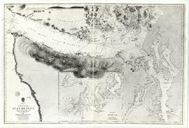
- Jan. 18, 1849, with corrections to Aug. 1864 (copied between 1973 and 1975)
Part of City of Vancouver Archives technical and cartographic drawing collection
Item is a reproduction of a map of the Strait of Juan de Fuca, including the southern tip of Vancouver Island, the southern Gulf Islands and adjacent mainland, Admiralty Inlet and Puget Sound.
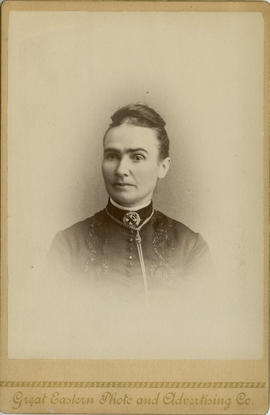
![[Full length studio portrait of] Mrs. William (Smith) Cruise](/uploads/r/null/7/1/71f71400c2bdefd36af8e77d542cba6fe342db89542c9756f73e49e61c215e3e/925157ed-ac31-4e4c-ad57-ced2c0842510-A02348_142.jpg)

![[Major General Rogers]](/uploads/r/null/a/3/a333117c00981139680e76a0e8aedc2cd65e70482f18e1975e8b65a4652cb3bd/f2392132-8a65-4033-985b-cec709296a81-A34506_142.jpg)


![[Railway yards] immediately below Keefer's house](/uploads/r/null/c/a/ca56324326d41d166dd0db141089c83221c7869a20d0cab1e7ca7098540254f1/68e97b63-8e1b-47cf-b430-980eaeb0e409-A25449_142.jpg)

![[Studio portrait of James Clephan and his niece Mary C. Elgood]](/uploads/r/null/3/e/3e1c721df90e310e5052ff6ec43b23755ae75a94bd038ec5ddf121703b67a127/902152e1-83d9-4347-b495-6e243e2eecde-A02349_142.jpg)
![[Twitchell family portrait]](/uploads/r/null/f/2/f2d141cc606e9875f8a6602813d801ade06e7a7f12215d049cefdade59848930/5eb2c486-7605-495e-ab38-b2562f57e4e6-CVA1477-434_142.jpg)


![[Soloman Oppenheimer]](/uploads/r/null/9/8/9841396e0499f4cfd63fba47b9905aa4843c571301344a9df881a88ad8302e22/7bdc8dbc-0d46-44c1-85fa-43669e4981c6-A34904_142.jpg)
![[Phillip Sullivan]](/uploads/r/null/2/2/22125fe7e955b8ecc888c2caebc058031383e9c5d422af0de2f9e32d99970f1d/5fb35d4d-7cb1-4940-99b0-8f1b1eed6766-A35099_142.jpg)
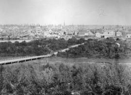
![[View of New Westminster from across the river]](/uploads/r/null/8/f/8f82aebb4c849e2bb1f74b79994fab8be690ff186aaa671c5ae8a966dbdf8a2f/2ca5abb4-a6d5-443d-85bc-25dcc6f7e5bd-A33970_142.jpg)
![[Seated studio portrait of] Chester and Hannah Chadsley](/uploads/r/null/f/4/f44245daa02a655708d138251c26082505523a8dce34d29d29d4ac19927f42da/9d0094f0-4ea1-420c-a450-aa5dc4c76787-A02669_142.jpg)
![[Studio portrait of man, standing, holding hat]](/uploads/r/null/2/4/249a5475156569e1a19e453f8dea42a098732513f31996c8be0444207e5214fe/50f180aa-40b7-47ec-bb18-091f5b58a8bc-A02162_142.jpg)
![[Studio portrait of young girl, reclining]](/uploads/r/null/a/2/a20ef1e880c2cfc0a727242fe3211b5bbc5c48874a8340083c4897cda4f12109/73f42ca2-7a59-4ff9-b889-53b58add3f90-A02121_142.jpg)
![[Head and shoulders portrait of woman]](/uploads/r/null/0/8/08afd6a58d3caf99fe1e6975898e281f6a79fc7e1fd41e5e06771a736f8a7caf/621aefb8-bfff-4591-b45a-bbf1f10c4955-A02130_142.jpg)
![[Louis Oppenheimer]](/uploads/r/null/3/4/3482369edf79bbdb30229039b17fb9847e9fcd8bd800d260ad552bf54e4dd8b1/ad7c41a9-e7b4-466b-90b2-77f7d55a689a-A35822_142.jpg)


![[Hugh McRoberts]](/uploads/r/null/d/5/d5d4316e30c9561b0947b134e622471b824cfc0885afc898324eca1c1166e8f0/d1910833-a3be-47df-8490-506b55c50e9a-A61987_142.jpg)