Free map of Vancouver, New Westminster and surroundings
Freight lines : British Columbia Electric Railway Company Limited, Vancouver and Lulu Island Railway Company (Canadian Pacific Railway Company, Lessee)
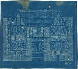
Front elevation
Front elevation : Leyland Apartments 916 West Broadway
Front elevation and section
Front page and index map
General development plan, Exhibition Park, Vancouver, B.C.
General Key of Atlas/Title Page
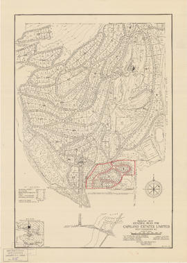
General plan for Capilano Estates Limited
Geological map of parts of Nanaimo and New Westminster mining divisions
Granville [fire insurance plan]
Granville [Townsite], B.C. Aug., 1885
Great Northern Railway. Map of the United States
Greater Vancouver
Greater Vancouver and Fraser Valley
Greater Vancouver road map : map cover
Greater Vancouver sewerage and drainage district : general and statistical information
Greater Vancouver votes October 17th : know your ward - know your poll
Greater Vancouver votes October 17th : know your ward - know your poll
Greater Vancouver, British Columbia : regional major street plan
Greater Vancouver's land resources
Greater Victoria provincial electoral districts
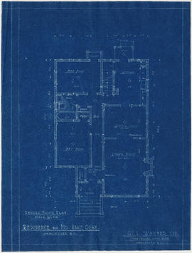
Ground floor plan
Ground floor plan
Grouse Mountain Park. North Vancouver, B.C.
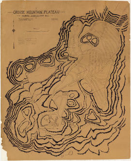
Grouse Mountain Plateau, North Vancouver, B.C.
Guide map : Vancouver, New Westminster, Burnaby and North Shore municipalities
Guide map : Vancouver, New Westminster, Burnaby and North Shore municipalities : street index
Guide map: Vancouver - New Westminster, Burnaby and North Shore municipalities
Guide map. Vancouver-New Westminster. Burnaby and North Shore municipalities
Haro Strait and middle channel
Hastings Townsite : Nanaimo Street to Renfrew Street and 13th Avenue to Strathcona Road (22nd Avenue)
Hastings Townsite : Nanaimo Street to Renfrew Street and Burrard Inlet to Cambridge Street
Hastings Townsite : Nanaimo Street to Renfrew Street and Strathcona Road (22nd Avenue) to Government Road (29th Avenue)
Hastings Townsite : Renfrew Street to Rupert Street and 5th Avenue to 13th Avenue
Hastings Townsite : Renfrew Street to Rupert Street and Strathcona Road (22nd Avenue) to Government Road (29th Avenue)
Hastings Townsite : Rupert Street to Boundary Road and 5th Avenue to 13th Avenue
Hastings Townsite : Rupert Street to Boundary Road and Pender Street to Charles Street
Hastings Townsite : Rupert Street to Boundary Road and Strathcona Road (22nd Avenue) to Government Road (29th Avenue)
Hastings Townsite [Boundary Road to 5th Avenue to Kamloops Street (?) to 33rd Avenue]
Hastings Townsite [Boundary Road to English Bay to Commercial Drive to Charles Street]


![Granville [fire insurance plan]](/uploads/r/null/f/3/1/f31b2fc3e34f1b2e375aa4d1c6089d069e20e5c43e88dd4a753a0ed961acd9c9/e011f916-304f-4655-9c90-c93af236fcbb-MAP334_142.jpg)
![Granville [Townsite], B.C. Aug., 1885](/uploads/r/null/1/a/4/1a45ddd637fe3f3726748d5096017a8461446b9a013c408ed2b1666c8433e1f9/405fdc0d-6d88-41b7-937f-36cc7f51518a-MAP553_142.jpg)


![Hastings Townsite [Boundary Road to 5th Avenue to Kamloops Street (?) to 33rd Avenue]](/uploads/r/null/7/f/0/7f0fe2a27b9af4f20ad7837792af3bbb3aa93c3487024e69b14fa38144134f19/8e7a0e66-c6cc-40ca-bbac-4ea73db77437-LEG1800_142.jpg)
![Hastings Townsite [Boundary Road to English Bay to Commercial Drive to Charles Street]](/uploads/r/null/f/f/f/fff4026408c5cdfe071e2699b8a35b248daec6b4d059622bf14a49b96a15fb3c/a21002e4-eead-4468-b03a-a44b355308fa-LEG1800_142.jpg)

![Howe Sound - Burrard Inlet [Burrard Inlet portion]](/uploads/r/null/f/8/5/f8523992bb5d5e0c1391f2dea183041a54a2d2470eb4047bb29958a0d835ae95/fdf9563d-923e-468a-a494-3ff190294b91-MAP30b_142.jpg)
![Howe Sound - Burrard Inlet [Howe Sound portion]](/uploads/r/null/7/a/1/7a1896077ddc37a7e16ac2d7e42a66031e13e11a9d966c43fca06cbb56f8bd96/5edd8d92-d3cd-4663-8fdd-996b3ae7a402-MAP30a_142.jpg)


