Print preview Close

Showing 1835 results

Archival description
City of Vancouver Archives technical and cartographic drawing collection
Print preview View:

1440 results with digital objects Show results with digital objects

Cheakamus power survey for City of Vancouver, 1930-1931 : topographical plan from Alpha Lake to C...
Cheakamus power survey for City of Vancouver, 1930-1931 : topographical plan from Alpha Lake to Cheakamus River, above Mile 34, P.G.E. Rly. : sheet no. 8 to accompany report of E.A. Cleveland dated November 30th 1931
Cheakamus power survey for City of Vancouver, 1930-1931 : plan showing topography southward along...
Cheakamus power survey for City of Vancouver, 1930-1931 : plan showing topography southward along a line from Cheakamus River near Mile 34, P.G.E. Rly. : sheet no. 9 to accompany report of E.A. Cleveland dated November 30th 1931
Cheakamus power survey for City of Vancouver 1930-1931 : plan showing proposed development from G...
Cheakamus power survey for City of Vancouver 1930-1931 : plan showing proposed development from Garibaldi Lake to Daisy Lake : sheet no. 10 to accompany report of E.A. Cleveland dated November 30th 1931
Plan of the Town of Port-Moody, British Columbia
It might have been Albert City, 1858, New Georgia 1792 : it was Granville, 1870, British Columbia...
It might have been Albert City, 1858, New Georgia 1792 : it was Granville, 1870, British Columbia, 1871 : it is Vancouver, 1886, British Columbia, 1871 : it is Vancouver, 1886, Canada, 1867
Sketch of proposed interurban canal and harbour development for Greater Vancouver, B.C.
South Western Districts [of British Columbia]
Carte de la parte de la cote nord-ouest de l'Amerique : recconnue pendant les etes de 1792, 1793 ...
Carte de la parte de la cote nord-ouest de l'Amerique : recconnue pendant les etes de 1792, 1793 and 1794, depuis 29D 54' de Latitude Nord et 244D 33' de Longitude Orientale, jusqu'au Cap Douglas par 58D 52' de Latitude et 207D 20' de Longitude, par le Ca
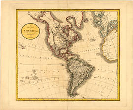
A new map of America, from the latest authorities
Johnson's North America
Carte particuliere de la cote du Nord-Ouest de l' Amerique reconnue par les fregates Francaises l...
Carte particuliere de la cote du Nord-Ouest de l' Amerique reconnue par les fregates Francaises la Boussole et l'Astrolabe en 1786, 2e. feuille
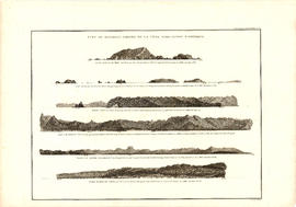
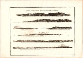
Vue de diverses parties de la côte nord-ouest d'Amérique
Map and information concerning the City and District of New Westminster and the Province of British Columbia
Map of the municipalities of New Westminster, British Columbia
Information concerning the City and District of New Westminster and the Province of British Columbia
City of Vancouver : Canadian Pacific town site
Plan of City of Vancouver
Plan of Vancouver Harbour and False Creek, Vancouver, B.C., showing proposed improvements as outl...
Plan of Vancouver Harbour and False Creek, Vancouver, B.C., showing proposed improvements as outlined in Jos. R. Roy's reports dated 15th Sept. 1906
Plan of False Creek, Vancouver, B.C.
Map of the business portion of the City of Vancouver, British Columbia [early street paving]
V.W.W. [Vancouver Water Works] plan shewing tunnel and tramway at Big Canon [Canyon]
Plan of the City of Vancouver, B.C.
B.C. Electric Railway lines completed and under construction
Vancouver, B.C.
Vancouver, B.C.
Shaughnessy Heights
Shaughnessy Heights
Burnaby municipality
The city of Vancouver
Vancouver, British Columbia : [urban analysis maps]
Vancouver : spectacular by nature : official courtesy map
Railroads of the Lower Mainland of British Columbia
Railroads of the Lower Mainland of British Columbia, 1882-1992
Existing development, 1970
Tidal current charts : Vancouver Harbour, British Columbia
Tidal current charts, Vancouver Harbour, British Columbia : front cover
Tidal current charts, Vancouver Harbour : inside front cover
Tidal current chart, Vancouver Harbour : two hours before maximum ebb at First Narrows
Tidal current chart, Vancouver Harbour : one hour before maximum ebb at First Narrows
Tidal current chart, Vancouver Harbour : maximum ebb at First Narrows
Tidal current chart, Vancouver Harbour : one hour after maximum ebb at First Narrows
Tidal current chart, Vancouver Harbour : two hours after maximum ebb at First Narrows
Tidal current chart, Vancouver Harbour : three hours after maximum ebb at First Narrows
Tidal current chart, Vancouver Harbour : two hours before maximum flood at First Narrows
Tidal current chart, Vancouver Harbour : one hour before maximum flood at First Narrows
Tidal current chart, Vancouver Harbour : maximum flood at First Narrows
Tidal current chart, Vancouver Harbour : one hour after maximum flood at First Narrows
Tidal current chart, Vancouver Harbour : two hours after maximum flood at First Narrows
Tidal current chart, Vancouver Harbour : three hours after maximum flood at First Narrows
Tidal current chart, Vancouver Harbour : inside back cover
[Map showing proposed electoral district boundaries within the Greater Vancouver area]
[Map showing proposed electoral district boundaries within the Greater Vancouver area]
Results 201 to 250 of 1835