
Greater Vancouver sewerage and drainage district : general and statistical information
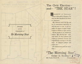
The civic election - and "The Star"!

The civic election - and "The Star"!

Advertisements for Vancouver real estate

Indexed map of Greater Vancouver : map cover and advertisements

Free map of Vancouver, New Westminster and surroundings
Target area civil defence survival instructions

Map and Guide to Vancouver Street Car and Interurban Lines

Greater Vancouver road map : map cover

Automobile road map of Greater Vancouver and environs : map cover

Automobile road map of Greater Vancouver and environs : inside map cover

City of Vancouver : residential lots, Area B, Champlain Heights : page 1

City of Vancouver : residential lots, Area B, Champlain Heights : page 2

Tidal current charts, Vancouver Harbour, British Columbia : front cover

Tidal current charts, Vancouver Harbour : inside front cover

Tidal current chart, Vancouver Harbour : inside back cover

Booklet cover

Index to streets and block numbers
Street index

Map cover

Street index of Vancouver and lower mainland

Wrigley's offical arrow city map : Greater Vancouver and New Westminster : map cover

Direct mail as an advertising and marketing medium

Through the Canadian Pacific Rockies : a large scale map of the mountains from Calgary to Sicamous : map cover

Through the Canadian Pacific Rockies : a large scale map of the mountains from Calgary to Sicamous : inside map cover

Sheet 1 : Slocan Street to Boundary Road and Triumph Street to Burrard Inlet

Sheet 2 : Slocan Street to Boundary Road and Charles Street to Triumph Street

Sheet 3 : Slocan Street to Boundary Road and Seventh Avenue to Charles Street

Sheet 4 : Slocan Street to Boundary Road and Broadway to Seventeenth Avenue

Sheet 5 : Slocan Street to Boundary Road and Seventeenth Avenue to Twenty-ninth Avenue

Sheet 6 : Knight Street to Slocan Street and Eighteenth Avenue to Twenty-ninth Avenue

Sheet 7 : Clark Drive to Slocan Street and Seventh Avenue to Eighteenth Avenue

Sheet 8 : McLean Drive to Slocan Street and William Street to Seventh Avenue

Sheet 9 : Clark Drive to Slocan Street and Triumph Street to Charles Street

Sheet 10 : Clark Drive to Slocan Street and waterfront to Triumph Street
![City of Vancouver, British Columbia [index map]](/uploads/r/null/d/4/d4fc7ef393680c6515927aa960de863e6fd9e846c3fac12499691549673dc4b7/eed36b0b-2e63-48f2-a7ee-02ed3de937b9-MAP682_142.jpg)
City of Vancouver, British Columbia [index map]

Plan of district lot boundaries, City of Vancouver, B.C.

Sheet 11 : Carrall Street to Clark Drive and waterfront to Keefer Street

Sheet 12 : Ontario Street to Clark Drive and Keefer Street to Second Avenue

Sheet 13 : Ontario Street to Clark Drive and First Avenue to Sixteenth Avenue

Sheet 14 : Main Street to Knight Street and Fifteenth Avenue to King Edward Street

Sheet 15 : Oak Street to Main Street and False Creek to Sixteenth Avenue

Sheet 16 : Maple Street to Oak Street and False Creek to Sixteenth Avenue

Sheet 17 : Trutch Street to Maple Street and Fourth Avenue to Sixteenth Avenue

Sheet 18 : Trutch Street to Maple Street and English Bay to Third Avenue

Sheet 19 : Maple Street to Richards Street and Drake Street to Third Avenue

Sheet 20 : Granville Street to Ontario Street and Robson Street to Sixth Avenue

Sheet 21 : Burrard Street to False Creek and waterfront to Robson Street

Sheet 22 : Stanley Park to Burrard Street and waterfront to Robson Street

Sheet 23 : Stanley Park to Granville Street and Robson Street to False Creek