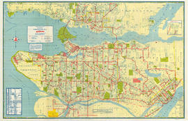
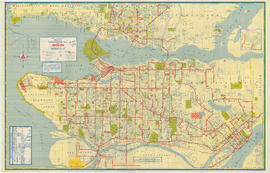
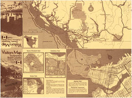
Showing 281 results

Archival description
City of Vancouver Archives technical and cartographic drawing collection
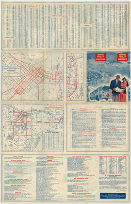
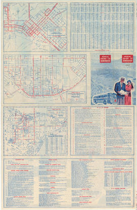
 Part
Print preview View:

246 results with digital objects Show results with digital objects

Hastings Townsite : Nanaimo Street to Renfrew Street and Burrard Inlet to Cambridge Street

Part is a sheet of a sectional map of Hastings Townsite showing streets, railways, legal addresses, some lot sizes, and municipal boundaries. Item has been annotated with information regarding property ownership and various symbols of unspecified meaning.

Hastings Townsite : Renfrew Street to Rupert Street and 5th Avenue to 13th Avenue

Part is a sheet of a sectional map of Hastings Townsite showing streets, railways, legal addresses, some lot sizes, and municipal boundaries. Item has been annotated with information regarding property ownership, including identification of properties included in a 1919 tax sale, and various symbols of unspecified meaning.

Hastings Townsite : Rupert Street to Boundary Road and 5th Avenue to 13th Avenue

Part is a sheet of a sectional map of Hastings Townsite showing streets, railways, legal addresses, some lot sizes, and municipal boundaries. Item has been annotated with information regarding property ownership, including identification of properties included in a 1919 tax sale, and various symbols of unspecified meaning.

Hastings Townsite : Nanaimo Street to Renfrew Street and 13th Avenue to Strathcona Road (22nd Avenue)

Part is a sheet of a sectional map of Hastings Townsite showing streets, railways, legal addresses, some lot sizes, and municipal boundaries. Item has been annotated with information regarding property ownership, including identification of properties included in a 1919 tax sale, and various symbols of unspecified meaning.

Hastings Townsite : Nanaimo Street to Renfrew Street and Strathcona Road (22nd Avenue) to Government Road (29th Avenue)

Part is a sheet of a sectional map of Hastings Townsite showing streets, railways, legal addresses, some lot sizes, and municipal boundaries. Item has been annotated with information regarding property ownership and various symbols of unspecified meaning.

Hastings Townsite : Renfrew Street to Rupert Street and Strathcona Road (22nd Avenue) to Government Road (29th Avenue)

Part is a sheet of a sectional map of Hastings Townsite showing streets, railways, legal addresses, some lot sizes, and municipal boundaries. Item has been annotated with information regarding property ownership and various symbols of unspecified meaning.

Hastings Townsite : Rupert Street to Boundary Road and Strathcona Road (22nd Avenue) to Government Road (29th Avenue)

Part is a sheet of a sectional map of Hastings Townsite showing streets, railways, legal addresses, some lot sizes, and municipal boundaries. Item has been annotated with information regarding property ownership and various symbols of unspecified meaning.

City of Vancouver. Canadian Pacific town site

Part is a map sheet with one principal map, three inset maps and one illustration. The main map is a copy of a L.A. Hamilton map of downtown Vancouver and the land surrounding False Creek. Textual information is provided about the history and layout of Stanley Park. Inset maps show the Canadian Pacific mail steamships lines around the world and an index plan of Vancouver, B.C. An illustration is incuded of the north shore mountains as seen from Vancouver.

Map of West Vancouver and North Vancouver, street index, real estate information, and list of golf courses

Part contains an illustrated map of West Vancouver and North Vancouver showing major streets, mountains, rivers and creeks, and recreational attractions; a street index to the Greater Vancouver map on the other side of the sheet; a list of golf courses; and real estate information including a description of professional realtors, an amortization table, and calculations showing amounts paid in rent over many years.

Map of Lulu Island and Sea Island ; Municipality of Delta ; Municipality of Surrey ; Municipality of Langley ; Map of Maillardville

Part contains street maps of Lulu Island and Sea Island, Delta, Surrey, Langley, and Maillardville, tourist information about Vancouver, and text advertising the products and services of the Dominion Map and Blueprint Company.

Dial map of Greater Vancouver and suburbs

Part contains a street map of Vancouver, Burnaby, New Westminster, West Vancouver and North Vancouver showing block numbers, street car, bus, and railway lines, parks and hospitals. Map includes two dials (a numbered circle, a paper indicator, a grid of block numbers and a street index used to find locations). A small inset map shows the Capitol Hill/Scenic Park area of Burnaby in greater detail.

Results 201 to 250 of 281