British Columbia pioneer reunion programme
- AM1519-: PAM 1924-1
- Item
- 1924
25 results with digital objects Show results with digital objects
British Columbia pioneer reunion programme
British Columbia Provincial Police Journal
British Columbia public accounts
British Columbia Sports Hall of Fame and Museum
Bruce Passmore's Langford speedway : official programme
Budget speech delivered by the Honourable John N. Turner, Minister of Finance
Bulman's map of the European war front with an insert of the Pacific theatre
Invasion map of Europe and a Salute to the Merchant Marine prepared by The Bulman Organization, Lithographers & Printers and addressed to Mr. Lauritzen, B.C. Lumber Mfrs. Assn., 906 Metropolitan Bldg., Vancouver, B.C. Verso contains text relating to the Merchant Navy.
Marianne Linnell Conservative. Campaign poster.
Business services, executive office centre, World Trade Centre office complex
Free souvenir - reprint of first Buy and Sell inserted in 1000th issue, June 4, 1987. Includes editorial policy as of November 28, 1971.
Callister Park, Vancouver, B.C., June 11th, 1956 : Aberdeen XI. vs. B.C. All Stars
Cambie Bridge : The Official Opening
Booklet issued to comemorate the opening of the Cambie Street Bridge on December 8, 1985. Contains histories of the former Cambie Bridge (1891-1911) and Connaught Bridge (1911-1984), and the construction techniques applied to the new bridge.
[Campaign brochure for Victor Forster]
[Campaign brochure on behalf of the Liberal Party prepared by volunteers]
[Campaign literature for Gerald McGeer]
Campbell McGeer for Point Grey
Can city governments make a difference? : you be the judge
"On Saturday Nov 19th 2005 please come out and vote! Come and meet some of the candidates on Sunday Nov 6th. . . . " Flyer features candidates Tim Louis, COPE; Anne Roberts, COPE; Fred Bass, COPE, Kevin Potvin, Independent.
Can we let our living heritage die? : would Mrs. Mole approve?
Canada : an illustrated weekly journal
Canadian Association of Fire Chiefs Annual conference
Canadian Conference of the Arts
Canadian Conference of the Arts May 1961: to measure Canada's cultural maturity
Canadian international dragon boat festival, June 23-25
Canadian monument to General Wolfe at Greenwich
Candidates of civic improvement group
Capt. Plunkett's ninth annual springtime revue " Bubbling over" : programme
Carnegie centre, Vancouver Public Library - before Carnegie
Carousel Theater company and school Winter 1988
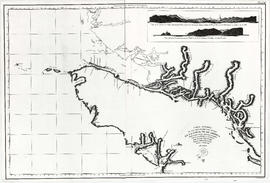
Part of City of Vancouver Archives technical and cartographic drawing collection
Item is a reproduction of a map depicting the Spanish explorations of the north-west coast of North American in 1795, specifically depicting the northern end of Vancouver Island and the adjacent mainland. Illustrations are views of the entrance to Nootka Sound, and a view of "Cabo Frondoso" (Cape Cook?).
Part of City of Vancouver Archives technical and cartographic drawing collection
Map shows Juan de Fuca Strait, the San Juan Islands and the southern portion of Vancouver Island.
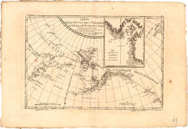
Carte de la cote N.O. de l' Amerique et de la cote N.E. de l'Asie
Part of City of Vancouver Archives technical and cartographic drawing collection
Item is a map showing the north west coast of America and the north east coast of Asia. Inset maps shows the entrance to Nootka Sound.

Part of City of Vancouver Archives technical and cartographic drawing collection
Map shows the Pacific Coast from Prince William Sound in the north though the Queen Charlotte Islands, Vancouver Island, Port S. Francisco and Sn. Diego to Sn. Domingo in the south.

Carte de la riviere de Cook dans la partie N.O. de l'Amerique
Part of City of Vancouver Archives technical and cartographic drawing collection
Item is a nautical chart showing "Cook's River" [Cook Inlet, Alaska]; the inset chart shows Oonalaska Island and gives soundings for "Samganoodha harbour" and the waters around the island.

Part of City of Vancouver Archives technical and cartographic drawing collection
Item is a map showing the Pacific Coast of British Columbia and Washington and Oregon states as surveyed by French explorer Jean-Francois de Galaup (Laperouse) in 1786, and the routes of his ships Astrolabe and Boussole. The map shows the Pacific coastline from Cap Rond (Tillamook Head) in Oregon at latitude 45 degrees and 40 minutes in the south to Baeie de Clonard (Beresford Bay, northwestern tip of Haida Gwaii) in British Columbia at latitude 54 degrees and 10 minutes in the north. Other major place names on the map include Nootka, Pointe Boisee, Baie St. Louis, Iles de Sartine, Mont Fleurieu, Cap Fleurieu, Cap Hector, Mont de la Touche, Baie de la Touche, and Baie de Clonard. Vancouver Island is shown as part of the mainland. Map includes latitudes and longtitudes as well as indication of elevations. Map is a plate from the "Atlas de Voyage de la Perouse".