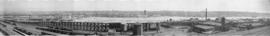
![[View of False Creek showing the Granville Island reclamation]](/uploads/r/null/4/5/45b94fe3950893e0165f625b8372fe0bdc7d5fb2842ae0028bb0d079ac4f0530/d4561665-20ad-4549-816c-1f4e4332e729-A63481_142.jpg)
[View of False Creek showing the Granville Island reclamation]
- AM54-S4-3-: PAN N98
- Item
- 20 Aug. 1917
Part of Major Matthews collection
Photograph also shows the Granville and the C.P.R. Kitsilano Trestle bridges, and the Kitsilano Indian Reserve.
2069 results with digital objects Show results with digital objects
[View of False Creek showing the Granville Island reclamation]
Part of Major Matthews collection
Photograph also shows the Granville and the C.P.R. Kitsilano Trestle bridges, and the Kitsilano Indian Reserve.
The village voice : on False Creek
"Embrace the village vibe and claim your place on the waterfront . . . last opportunities to own at the village. . . ."
The village on False Creek : your community : play, live, shop, work
"Your village is uniquely urban and inclusive, taking full advantage of its prime locale, the heart of new False Creek . . . ."
[Postcards : drawings of False Creek scenes]
Alder Bay Place : False Creek phase II
![[View of West Coast Shipbuilders Ltd. on the southeast shore of False Creek]](/uploads/r/null/f/4/f4e5ddf1021390fc837181077be738e8bc5b4b816a8aa0cbeed0a95582c0135c/c22372be-bcbb-4b2d-9077-f511a07c45da-A46301_142.jpg)
[View of West Coast Shipbuilders Ltd. on the southeast shore of False Creek]
![[Vancouver history and Vancouver in the 1930s]](/uploads/r/null/1/1/1112426/1a9be229-5f41-40b2-ae6b-d9d6f7819c8d-V00101_142.jpg)
[Vancouver history and Vancouver in the 1930s]
Part of City of Vancouver Archives sound recording and moving image collection
Item is a documentary film documenting a history of Vancouver using historical photographs, maps and records as well as street scenes of Vancouver in the 1930s. The historical portions of the film contain footage about the pioneers of Vancouver including Captain George Vancouver, John Morton (first resident of what was to become the City of Vancouver), Mr. Wm. Evans (engineer on the first transcontinental train into Port Moody), Lord Granville, John Robson, Richard Earl Howe, Admiral, and Sir Harry Burrard Neale. The film also contains footage of a map of First Narrows, Burrard Inlet, English Bay and nearby Government reserves as well as a map of False Creek, the West End and the East End. In addition there is footage of Hastings Mill (1887), Gastown (1887), the heart of the city (1884), the 1886 fire, City Hall after the fire, the CPR (1887), Indian ranches on Lost Lagoon, clearings near Stanley Park, Vancouver in 1888 and 1890, the entrance to Stanley Park (1890), as well as city scenes of Vancouver in the early twentieth century.

Sawmill fire and Jake Loeppky family
Part of City of Vancouver Archives sound recording and moving image collection
Item is an amateur film documenting family life and a sawmill fire in Vancouver. The film consists of home movie footage filmed by Jake Loeppky, including footage of Queen Elizabeth Park, the Stanley Park Zoo, children playing at the family home in Burnaby, children swimming, and the family entertaining at home. The film also includes footage of a logging camp, a large dam, bears, and people waterskiing. Of particular note is several minutes of footage of the five-alarm fire that destroyed the B.C. Forest Products plant and lumber storage facility at 999 West 6th Avenue on July 3, 1960.


Part of City of Vancouver Archives documentary art collection
Print shows sawmills on False Creek.
![Old Granville Bridge [being demolished]](/uploads/r/null/f/5/f58376a7599865f0e9a1f088cf422b06bb108774f7828b0ab9487ed99d38eb57/7f281b22-6df9-46ac-a44a-60d879c194bd-A21671_142.jpg)
Old Granville Bridge [being demolished]
Part of Walter E. Frost fonds
Photograph shows the western section of False Creek North.
![[View of the C.P.R. Kitsilano Trestle Bridge]](/uploads/r/null/3/8/3851efec79ac362a7ebd551dd414a83640dc0d49dd5103276db4f425a86a290c/5af0eb40-300b-4c15-bf19-faa287cec340-A21654_142.jpg)
[View of the C.P.R. Kitsilano Trestle Bridge]
Part of Walter E. Frost fonds
![[Southeast view from the top of the old Hotel Vancouver]](/uploads/r/null/1/5/15ba74b0c21b3c68df50b4e0a0c7c7664d37525eabb1899ab8db6eae2fef35b9/6cdcd0a1-c54d-47ed-9fa0-a6fd3992e788-A21941_142.jpg)
[Southeast view from the top of the old Hotel Vancouver]
Part of Walter E. Frost fonds
Photograph shows the Canadian National Railway Station, Georgia Viaduct, Beatty Street Armoury, B.C.E. R. gas tank, the spire of St. Andrew's Chruch and False Creek.
False Creek: history, images, and research sources.
Old lands - new plans : False Creek Rail Lands : October 1994
False Creek Ferries : Vancouver, Canada : 2001-2002 schedule
False Creek Ferries : Serving False Creek for 20 years : Vancouver, Canada 2002 - 2003 schedule
False Creek's watershed then and now
"False Creek's lost streams - where did they go? Although all of the creeks that flowed into False Creek have completely disappeared under the urban landscape, they played an important part in Vancouver's development and prosperity. . . . "
![[Aerial view of Vancouver]](/uploads/r/null/9/b/9b3acec26123edc53f11bf2f41f3286d09254ffea9918cd31b6715395ebe18d0/26473909-fe49-4474-8c3f-05eb1e8ab059-CVA1376-252_142.jpg)
Oblique view showing Fairview, Vancouver General Hospital, False Creek and the Expo 86 and other sites under development on the north side, Granville Island, Granville Bridge, Burrard Bridge, Yaletown, Downtown, the West End, Stanley Park and the Lions Gate Bridge, North Vancouver and The Lions in the background
![[View of False Creek looking east from the Burrard Bridge]](/uploads/r/null/8/4/84922323cf591c851fbd4ab5489c940a600fdeb6911c11e122f77b8c798c04a2/5a3406ee-9419-4ebd-bd85-d51cecb6e953-A03428_142.jpg)
[View of False Creek looking east from the Burrard Bridge]
Photograph shows the Kitsilano Trestle and Granville Bridges
False Creek (south side) - 1973 to 1999
False Creek (south side) - 1977 to 1996
![[View of False Creek looking north showing Connaught (Cambie Street) Bridge]](/uploads/r/null/8/1/815bb733e4089f8751bb890c421ea1148d0be1e25a3b0b6f19729fd28e7e1e21/26186219-e90b-47d5-a07b-6446f4fca9df-A20538_142.jpg)
[View of False Creek looking north showing Connaught (Cambie Street) Bridge]
Part of James Luke Quiney fonds
![[View of False Creek looking north from 12th Avenue and Oak Street]](/uploads/r/null/0/4/049a62f5986b294c107664ef819fc7ee441a93066f4230802ac78373ff9c2bb3/a2675ba1-4bfa-41ed-9574-0ad9c213da88-A20539_142.jpg)
[View of False Creek looking north from 12th Avenue and Oak Street]
Part of James Luke Quiney fonds
![[Northward view of J. Hanbury and Co. Sawmill showing Granville Island under construction]](/uploads/r/null/8/3/83ec7ab11b42b6bf1a8155c4aed40ccaf92b3a8ae6208e0e307e926d273df42a/11514f5d-7e4e-4a98-a68a-7876f4c8abfd-A64091_142.jpg)
[Northward view of J. Hanbury and Co. Sawmill showing Granville Island under construction]
Part of Major Matthews collection
Photograph also shows the Granville Bridge, other False Creek mills and industrial buildings and Fairview Slopes to the far right.
False Creek Backgrounder (Urban Comm. [Committee])
Part of Co-op Radio fonds
Item is an audio reel containing a recording of an interview by [Shayla Freeman] with Neil Griggs of the False Creek Development Team. Note on case: "3rd of 3" [possibly 3rd reel of a total of three reels].
![[J.Hanbury and Co. Mill and view of False Creek]](/uploads/r/null/a/2/a2dd45a666a252ca69ac0607e0307872381813b811490a51bc2e0f0425a8c527/a7e6e35d-dab7-4d57-ae4c-351909234369-A62329_142.jpg)
[J.Hanbury and Co. Mill and view of False Creek]
Part of Major Matthews collection
Photograph also shows the Granville Bridge

Vancouver, B.C. From The Lee Block July 7-1913
Part of Major Matthews collection
Photograph shows Mount Pleasant Public School, False Creek, Downtown and the Cambie Street Bridge.
![[J. Hanbury and Co. Mill, False Creek]](/uploads/r/null/5/6/56c2e92eaa1393ff529f2db401b75551c5528454bacac656e29fb0d8727ea0cf/6e5baaca-a796-433c-a463-ab67e23ae1d1-A63494_142.jpg)
[J. Hanbury and Co. Mill, False Creek]
Part of Major Matthews collection
Photograph shows the Granville Bridge.

Part of Major Matthews collection
Panoramic view showing the Granville Bridge with the span open, C.P.R. Trestle Bridge, Robertson and Hacket Sawmill, Canadian Pipe Co., Vancouver Granite Co. and Marpole Coal Co.

Part of Major Matthews collection
Panoramic view showing Granville Street Bridge, C.P.R. Kitsilano Trestle, and the Kitsilano Indian Reserve.
Part of Major Matthews collection
Panoramic view showing the dredging of False Creek for the Granville Island construction.
![[View of False Creek Flats east of Main Street]](/uploads/r/null/2/2/22ae18e3c70f3b175e8da170286e28bec8b9c5badf5f7209cd805214ba4c2778/0054a24e-3793-409f-a191-486d3c0e0479-A63167_142.jpg)
[View of False Creek Flats east of Main Street]
Part of Major Matthews collection
Panoramic view showing the start of the False Creek reclamation, the Great Northern Railway Station construction site, the Main Street bascule bridge, Market Hall and Ivanhoe Hotel.

Part of Major Matthews collection
Panoramic view showing the CN Freight shed, (temporary) Evangelistic Tabernacle, City Market building, the Globe and Ivanhoe Hotels and the swing span of the G.N.R. Trestle Bridge.
![[View of Mount Pleasant from the Lee Block, Broadway and Main]](/uploads/r/null/b/1/b1a10591488c68f9a18122cfa8f608fad319fbfa89c13392ad025d4afb3764d6/e0494038-a598-4615-af30-8ee294062605-A61801_142.jpg)
[View of Mount Pleasant from the Lee Block, Broadway and Main]
Part of Major Matthews collection
Photograph also shows False Creek east of Main, Downtown Vancouver and the Cambie Street Bridge in the background. Some prominent buildings include: Quebec Manor, Arcadian Hall, Dudley Block, Muir Apartments and Mount Pleasant Public School.
Item is a promotional pamphlet for The Village on False Creek.

Aerial photo, vertical, Deadman's Island, Coal Harbour and surrounding area
Item is a photograph of Deadman's Island, including Coal Harbour, and the southwest part of Stanley Park. Compass north is the left side of the photo.

Aerial photo, vertical, False Creek, Fairview to Kits Point
Item is a photograph of False Creek, showing English Bay to W 16th Avenue, and from Maple Street to the Cambie Street Bridge. Includes the Burrard Street Bridge, the new Granville Bridge, the Cambie Bridge, and Granville Island.