![[Log booms in False Creek]](/uploads/r/null/f/5/f550243b860a51f5ec457cf274b2623c13752319dd5a319f265dbf61ceadaa21/6ce86de1-00d0-4811-8f36-44264d095e99-A75588_142.jpg)
- AM640-S1-: CVA 260-569
- Item
- 1936
Part of James Crookall fonds
2063 results with digital objects Show results with digital objects
Part of James Crookall fonds
![[Log booms in False Creek]](/uploads/r/null/4/7/4773cc1ae813502c81a6cda0d2de46e4b70e67b816dd2c8c7b059fa4163911cc/d30dc4fe-d5ce-4180-8ef4-1c471f75a52b-A75587_142.jpg)
Part of James Crookall fonds
![[Log booms in False Creek]](/uploads/r/null/d/6/d66bf9825d215a378290e2cdb75e697f851b0f7f7b12a14693642c26e4b6ef87/c3722fd7-333e-4294-91fc-6da49d432621-A75586_142.jpg)
Part of James Crookall fonds
![[View of mills on False Creek]](/uploads/r/null/0/b/0be27bc58a5e995b0e07ae9e8d4aed255c9276ab84aea047777e1c931b3b5a16/6186ab3c-0182-43a5-9672-b52bb065ce06-A75583_142.jpg)
[View of mills on False Creek]
Part of James Crookall fonds
![[View of mills on False Creek]](/uploads/r/null/1/3/139c96ee1a7ea161c6fcccaf9a399e3a2d2c03de93eea7241144e4a489b9d928/8310b49e-6ded-4607-8757-e93c6d58345f-A75582_142.jpg)
[View of mills on False Creek]
Part of James Crookall fonds
![[View of buildings at the north end of the G.N.R. trestle bridge at the east end of ] False Creek](/uploads/r/null/0/6/0646f83230067a1dcdda83247d2ada2ebab61ab3819ee174cc8a67676e7defbc/b56bcafa-c3a0-46ed-b97c-999ada719740-A70779_142.jpg)
[View of buildings at the north end of the G.N.R. trestle bridge at the east end of ] False Creek
Part of H.A. Price collection

Part of City of Vancouver fonds

Part of City of Vancouver fonds

False Creek - Seawall - official opening
Part of City of Vancouver fonds

False Creek - Seawall - official opening
Part of City of Vancouver fonds

False Creek - Seawall - official opening
Part of City of Vancouver fonds

False Creek - Seawall - official opening
Part of City of Vancouver fonds

False Creek - Seawall - official opening
Part of City of Vancouver fonds

False Creek - Seawall - official opening
Part of City of Vancouver fonds

False Creek - Seawall - official opening
Part of City of Vancouver fonds

False Creek - Seawall - official opening
Part of City of Vancouver fonds

False Creek - Seawall - official opening
Part of City of Vancouver fonds
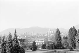
Downtown view over Fairview neighborhood
Part of City of Vancouver fonds
Item part is a photograph of the top of the downtown Vancouver skyline over the trees of a Fairview neighborhood. This photograph was taken from one of the lower floors of the Plaza 500 Hotel & Convention Centre.

Downtown view over Fairview neighborhood
Part of City of Vancouver fonds
Item part is a photograph of the top of the downtown Vancouver skyline over the trees of a Fairview neighborhood. This photograph was taken from one of the lower floors of the Plaza 500 Hotel & Convention Centre.

Downtown view over Fairview neighborhood
Part of City of Vancouver fonds
Item part is a photograph of the top of the downtown Vancouver skyline over the trees of a Fairview neighborhood. This photograph was taken from one of the lower floors of the Plaza 500 Hotel & Convention Centre.

Downtown cityscape over Mount Pleasant and False Creek
Part of City of Vancouver fonds

Downtown cityscape over Mount Pleasant, Fairview, and False Creek
Part of City of Vancouver fonds
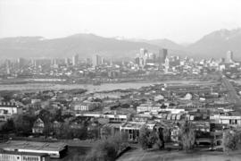
Item part is a photograph of downtown Vancouver, including a view down Cambie Street across the Cambie Street Bridge, and adjacent neighborhoods in Fairview and Mount Pleasant.

Downtown cityscape over Mount Pleasant, Fairview, and False Creek
Part of City of Vancouver fonds
Item part is a photograph of downtown Vancouver, including a view down Cambie Street across the Cambie Street Bridge, and adjacent neighborhoods in Fairview and Mount Pleasant.

Downtown cityscape over Fairview, and False Creek
Part of City of Vancouver fonds

Downtown cityscape over Mount Pleasant, Fairview, and False Creek
Part of City of Vancouver fonds
Item part is a photograph of downtown Vancouver, including a view down Cambie Street across the Cambie Street Bridge, and adjacent neighborhoods in Fairview and Mount Pleasant.
Downtown cityscape over Mount Pleasant, Fairview, and False Creek
Part of City of Vancouver fonds
Item part is a photograph of downtown Vancouver, including a view down Cambie Street across the Cambie Street Bridge, and adjacent neighborhoods in Fairview and Mount Pleasant.

Downtown cityscape over Fairview, and False Creek
Part of City of Vancouver fonds

Downtown cityscape over Mount Pleasant, Fairview, and False Creek
Part of City of Vancouver fonds
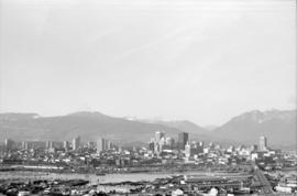
Item part is a photograph of downtown Vancouver, including a view down Cambie Street across the Cambie Street Bridge, and adjacent neighborhoods in Fairview and Mount Pleasant. The Granville Street Bridge and the Burrard Street Bridge are visible at the far left.

Downtown cityscape over Mount Pleasant, Fairview, and False Creek
Part of City of Vancouver fonds
Item part is a photograph of downtown Vancouver, including a view down Cambie Street across the Cambie Street Bridge, and adjacent neighborhoods in Fairview and Mount Pleasant.

Downtown cityscape over Mount Pleasant, Fairview, and False Creek
Part of City of Vancouver fonds
Item part is a photograph of downtown Vancouver, including a view down Cambie Street across the Cambie Street Bridge, and adjacent neighborhoods in Fairview and Mount Pleasant.
Downtown cityscape over Mount Pleasant, Fairview, and False Creek
Part of City of Vancouver fonds
Item part is a photograph of downtown Vancouver, including a view down Cambie Street across the Cambie Street Bridge, and adjacent neighborhoods in Fairview and Mount Pleasant.

Downtown cityscape over Mount Pleasant, Fairview, and False Creek
Part of City of Vancouver fonds
Item part is a photograph of downtown Vancouver, including a view down Cambie Street across the Cambie Street Bridge, and adjacent neighborhoods in Fairview and Mount Pleasant.

Downtown cityscape over Mount Pleasant, Fairview, and False Creek
Part of City of Vancouver fonds
Item part is a photograph of downtown Vancouver, including a view down Cambie Street across the Cambie Street Bridge, and adjacent neighborhoods in Fairview and Mount Pleasant.

Downtown cityscape over Fairview and False Creek
Part of City of Vancouver fonds
Item part is a photograph of downtown Vancouver over Fairview and False Creek. The Granville Street Bridge and the Burrard Street Bridge are visible at the far left.

Park on Beach Avenue, facing south
Item is a photograph of park space on Beach Avenue, looking south towards False Creek. The view includes an unidentified building is on the left, park benches, lawn, and a hydrant in the middle, and a pathway with access to the water on the right. There is a sidewalk visible in the foreground.

Park on Beach Avenue, facing south with children and woman
Item is a photograph of park space on Beach Avenue, looking south towards False Creek. The view includes children posing on the grass in the middle and a woman with a sun umbrella sitting on a bench. Across False Creek can be seen the area that became Vanier Park.
![[Alberta Lumber Co. mill and pier at False Creek]](/uploads/r/null/1/8/18df92f5edf42fb665076f24c657b29241af25a876f352ff337b6d730afac382/3722178f-db16-4fe1-a7fe-f1817dc44bc5-A63391_142.jpg)
[Alberta Lumber Co. mill and pier at False Creek]
Part of Major Matthews collection
Photograph also shows the North Shore Mountains.
![[Alberta Lumber Co. mill at False Creek]](/uploads/r/null/f/a/fa497107709fa724f44152ed366cf9d0f1c67da735ee94dfb7fa4a8c2a6590b9/69300167-a745-4e76-982a-306c295951b9-A63394_142.jpg)
[Alberta Lumber Co. mill at False Creek]
Part of Major Matthews collection
Photograph alo shows the North Shore mountains in the background.
![[View looking south from False Creek] Photo Taken on June 1st 1916.Time 1140. Tide 0.4.](/uploads/r/null/a/e/aed4784758988849388cd8a8825df6b5e02879445ce3fe8c0cd9d73201329ef0/67b3e89d-dcb9-450f-a95b-0008384c611d-A63476_142.jpg)
[View looking south from False Creek] Photo Taken on June 1st 1916.Time 1140. Tide 0.4.
Part of Major Matthews collection
Photograph shows the south shore of False Creek, houses and builidings in Fairview Slopes, the construction of Granville Island, Granville Bridge and the Kitsilano Trestle Bridge.
![[View of False Creek showing Granville Island and the Fairview waterfront]](/uploads/r/null/4/2/423d09208aeefd27222da460ea6826eee0597876cc74ac7c9bb3fe5624d3b5c0/a526f354-239a-41f1-a3ed-a70ca1cdf66e-A63472_142.jpg)
[View of False Creek showing Granville Island and the Fairview waterfront]
Part of Major Matthews collection

Vancouver From The Lee Block. Corner Broadway and Main Street
Part of Major Matthews collection
Photograph shows Mount Pleasant Public School, False Creek, The Cambie Street Bridge.
![[View of False Creek showing the Granville Island reclamation]](/uploads/r/null/4/5/45b94fe3950893e0165f625b8372fe0bdc7d5fb2842ae0028bb0d079ac4f0530/d4561665-20ad-4549-816c-1f4e4332e729-A63481_142.jpg)
[View of False Creek showing the Granville Island reclamation]
Part of Major Matthews collection
Photograph also shows the Granville and the C.P.R. Kitsilano Trestle bridges, and the Kitsilano Indian Reserve.
![[View of West Coast Shipbuilders Ltd. on the southeast shore of False Creek]](/uploads/r/null/f/4/f4e5ddf1021390fc837181077be738e8bc5b4b816a8aa0cbeed0a95582c0135c/c22372be-bcbb-4b2d-9077-f511a07c45da-A46301_142.jpg)
[View of West Coast Shipbuilders Ltd. on the southeast shore of False Creek]


Part of City of Vancouver Archives documentary art collection
Print shows sawmills on False Creek.
![Old Granville Bridge [being demolished]](/uploads/r/null/f/5/f58376a7599865f0e9a1f088cf422b06bb108774f7828b0ab9487ed99d38eb57/7f281b22-6df9-46ac-a44a-60d879c194bd-A21671_142.jpg)
Old Granville Bridge [being demolished]
Part of Walter E. Frost fonds
Photograph shows the western section of False Creek North.
![[View of the C.P.R. Kitsilano Trestle Bridge]](/uploads/r/null/3/8/3851efec79ac362a7ebd551dd414a83640dc0d49dd5103276db4f425a86a290c/5af0eb40-300b-4c15-bf19-faa287cec340-A21654_142.jpg)
[View of the C.P.R. Kitsilano Trestle Bridge]
Part of Walter E. Frost fonds
![[Southeast view from the top of the old Hotel Vancouver]](/uploads/r/null/1/5/15ba74b0c21b3c68df50b4e0a0c7c7664d37525eabb1899ab8db6eae2fef35b9/6cdcd0a1-c54d-47ed-9fa0-a6fd3992e788-A21941_142.jpg)
[Southeast view from the top of the old Hotel Vancouver]
Part of Walter E. Frost fonds
Photograph shows the Canadian National Railway Station, Georgia Viaduct, Beatty Street Armoury, B.C.E. R. gas tank, the spire of St. Andrew's Chruch and False Creek.