![[Log booms in False Creek]](/uploads/r/null/d/6/d66bf9825d215a378290e2cdb75e697f851b0f7f7b12a14693642c26e4b6ef87/c3722fd7-333e-4294-91fc-6da49d432621-A75586_142.jpg)
- AM640-S1-: CVA 260-567
- Item
- 1936
Part of James Crookall fonds
Part of James Crookall fonds
![[Log booms in False Creek]](/uploads/r/null/f/5/f550243b860a51f5ec457cf274b2623c13752319dd5a319f265dbf61ceadaa21/6ce86de1-00d0-4811-8f36-44264d095e99-A75588_142.jpg)
Part of James Crookall fonds
![[Mills on False Creek]](/uploads/r/null/4/8/484464a7c6f3891c53e9dd53b67dd525cb39f96f5cbfd54b3910d5eaf5b30721/e75a48e1-1600-419a-a572-9e268c856b75-A75566_142.jpg)
Part of James Crookall fonds
![Mini-park - South foot of Gladstone Street - Fraser River [1 of 15]](/uploads/r/null/e/a/eac8e55edb1d16bf3c9db39c72360cc377d9b6fba568c432fa86651f0b93fcfa/95e7ef10-fc5b-4387-a4a1-e08d1f95544e-A66068_142.jpg)
Mini-park - South foot of Gladstone Street - Fraser River [1 of 15]
Part of City of Vancouver fonds
![Mini-park - South foot of Gladstone Street - Fraser River [10 of 15]](/uploads/r/null/a/1/a165ad37b9ff84d7f11908bb98797752323907a679482ffba077e9e073008b68/a72d3c8c-f495-4d54-a461-039b9789fc80-A66077_142.jpg)
Mini-park - South foot of Gladstone Street - Fraser River [10 of 15]
Part of City of Vancouver fonds
![Mini-park - South foot of Gladstone Street - Fraser River [11 of 15]](/uploads/r/null/b/4/b4bb994e94adba160dfd70cd6715c80bcd6249694d7258428d31c284fcaac4c2/e1f3b6aa-9bb7-4e2c-8ede-05019a3f8bc9-A66078_142.jpg)
Mini-park - South foot of Gladstone Street - Fraser River [11 of 15]
Part of City of Vancouver fonds
![Mini-park - South foot of Gladstone Street - Fraser River [12 of 15]](/uploads/r/null/b/8/b84e541260a176eaf01524a7db37517c2393ce755b6d246926afffb87cbc2aee/fa96de2c-b419-4a46-ae8b-c39eb9d6bc96-A66079_142.jpg)
Mini-park - South foot of Gladstone Street - Fraser River [12 of 15]
Part of City of Vancouver fonds
![Mini-park - South foot of Gladstone Street - Fraser River [13 of 15]](/uploads/r/null/0/b/0bdc66ddd016b7a07b414ffe5ceb5e977e8e47aec146d3eb9d38a02c9889d304/9b513985-b7ac-4b02-b012-b5c6f97fb2db-A66080_142.jpg)
Mini-park - South foot of Gladstone Street - Fraser River [13 of 15]
Part of City of Vancouver fonds
![Mini-park - South foot of Gladstone Street - Fraser River [14 of 15]](/uploads/r/null/d/4/d4df5e8b36d4ea31ef1c0546a78555e43b37013da7180a9c741858adf5f9bcba/7d7e08a6-53ce-4e74-8a7d-916eca30e1e1-A66081_142.jpg)
Mini-park - South foot of Gladstone Street - Fraser River [14 of 15]
Part of City of Vancouver fonds
![Mini-park - South foot of Gladstone Street - Fraser River [15 of 15]](/uploads/r/null/9/d/9d9373891377ebc6b2b9de43159d89cc7e3bf6082ea65429a9a69b0b250a8fb9/6ca26cf6-ec87-4631-93a3-184805b389e4-A66082_142.jpg)
Mini-park - South foot of Gladstone Street - Fraser River [15 of 15]
Part of City of Vancouver fonds
![Mini-park - South foot of Gladstone Street - Fraser River [2 of 15]](/uploads/r/null/9/5/95f6f68046ab3e444915a98ecfaa06921934d43254d49f78e238cc715b69724f/5267771e-7da6-49f1-aa01-514815375a52-A66069_142.jpg)
Mini-park - South foot of Gladstone Street - Fraser River [2 of 15]
Part of City of Vancouver fonds
![Mini-park - South foot of Gladstone Street - Fraser River [3 of 15]](/uploads/r/null/7/9/796b547aa587eb8610c986c5a8e31e15dc34af223b617f90d447207c29d85665/010877b3-21ee-4a71-80ae-6a83ba13e8ea-A66070_142.jpg)
Mini-park - South foot of Gladstone Street - Fraser River [3 of 15]
Part of City of Vancouver fonds
![Mini-park - South foot of Gladstone Street - Fraser River [4 of 15]](/uploads/r/null/b/1/b1d5bbb8e4f3890752600c53dfc0de0bde461ec4a87b38882c7237e0153746c6/546b792a-0ba5-4aa3-8f9d-6411b418ac59-A66071_142.jpg)
Mini-park - South foot of Gladstone Street - Fraser River [4 of 15]
Part of City of Vancouver fonds
![Mini-park - South foot of Gladstone Street - Fraser River [5 of 15]](/uploads/r/null/9/3/93d20bed952e69943e481cec8de08df862282884eefb8cd0b3f2fed0e5127e2f/d82c422c-672d-4fac-bcd5-3cbdea2ce698-A66072_142.jpg)
Mini-park - South foot of Gladstone Street - Fraser River [5 of 15]
Part of City of Vancouver fonds
![Mini-park - South foot of Gladstone Street - Fraser River [6 of 15]](/uploads/r/null/d/9/d97e44557aa4f39ca8b151f6d6898f395b9837aa18952150be99f1e31b049441/68442d88-0119-456a-ac2e-509ff54427ad-A66073_142.jpg)
Mini-park - South foot of Gladstone Street - Fraser River [6 of 15]
Part of City of Vancouver fonds
![Mini-park - South foot of Gladstone Street - Fraser River [7 of 15]](/uploads/r/null/c/c/cc51f1579a091d770229fc06893e2d713f41f4e5c57080de550c701f40439c42/f8fa0361-f9d3-4de9-be43-e7a1ecb8e7ed-A66074_142.jpg)
Mini-park - South foot of Gladstone Street - Fraser River [7 of 15]
Part of City of Vancouver fonds
![Mini-park - South foot of Gladstone Street - Fraser River [8 of 15]](/uploads/r/null/d/c/dcdd62bca0cda3daa884cbc6c759c2857980a9c4795342a502384303554415bf/d23bd79e-6e75-4f77-a36d-6a484f496daf-A66075_142.jpg)
Mini-park - South foot of Gladstone Street - Fraser River [8 of 15]
Part of City of Vancouver fonds
![Mini-park - South foot of Gladstone Street - Fraser River [9 of 15]](/uploads/r/null/1/a/1abb02622db44e032366912ea872f1929bfc7717a9469fc605f93ec28e15ff3b/a79dc6d7-5e8d-4e0d-9703-e12d92b5287e-A66076_142.jpg)
Mini-park - South foot of Gladstone Street - Fraser River [9 of 15]
Part of City of Vancouver fonds
![Miscellaneous [85 of 130]](/uploads/r/null/f/1/f15ebac839f081682f3b154129642912983726072dabc10695811792428fe13b/f05b0553-2e3b-430c-ba58-c1cc1e738ee9-A67517_142.jpg)
Part of City of Vancouver fonds

Part of William Eadington Graham fonds

Part of William Eadington Graham fonds
Part of William Eadington Graham fonds
![[Northeast view of False Creek]](/uploads/r/null/c/b/cb30fde9722b8b64fd3b7e25f7487dfe9b743e7495319068d8ee15205635a8d1/982986e0-014c-4224-a34c-78e2d1d69b3f-A59369_142.jpg)
[Northeast view of False Creek]
Part of City of Vancouver fonds
![[Northward view of J. Hanbury and Co. Sawmill showing Granville Island under construction]](/uploads/r/null/8/3/83ec7ab11b42b6bf1a8155c4aed40ccaf92b3a8ae6208e0e307e926d273df42a/11514f5d-7e4e-4a98-a68a-7876f4c8abfd-A64091_142.jpg)
[Northward view of J. Hanbury and Co. Sawmill showing Granville Island under construction]
Part of Major Matthews collection
Photograph also shows the Granville Bridge, other False Creek mills and industrial buildings and Fairview Slopes to the far right.
![Old Granville Bridge [being demolished]](/uploads/r/null/f/5/f58376a7599865f0e9a1f088cf422b06bb108774f7828b0ab9487ed99d38eb57/7f281b22-6df9-46ac-a44a-60d879c194bd-A21671_142.jpg)
Old Granville Bridge [being demolished]
Part of Walter E. Frost fonds
Photograph shows the western section of False Creek North.

Park on Beach Avenue, facing south
Item is a photograph of park space on Beach Avenue, looking south towards False Creek. The view includes an unidentified building is on the left, park benches, lawn, and a hydrant in the middle, and a pathway with access to the water on the right. There is a sidewalk visible in the foreground.

Park on Beach Avenue, facing south with children and woman
Item is a photograph of park space on Beach Avenue, looking south towards False Creek. The view includes children posing on the grass in the middle and a woman with a sun umbrella sitting on a bench. Across False Creek can be seen the area that became Vanier Park.

Sawmill fire and Jake Loeppky family
Part of City of Vancouver Archives sound recording and moving image collection
Item is an amateur film documenting family life and a sawmill fire in Vancouver. The film consists of home movie footage filmed by Jake Loeppky, including footage of Queen Elizabeth Park, the Stanley Park Zoo, children playing at the family home in Burnaby, children swimming, and the family entertaining at home. The film also includes footage of a logging camp, a large dam, bears, and people waterskiing. Of particular note is several minutes of footage of the five-alarm fire that destroyed the B.C. Forest Products plant and lumber storage facility at 999 West 6th Avenue on July 3, 1960.
![[Sawmill on False Creek]](/uploads/r/null/b/0/b04708c4560b430def4212011e68117acb07b38eb56843a46386f7b1d7a89497/f2d44c33-8e99-472c-8a72-7accb5e8ee56-A59353_142.jpg)
Part of City of Vancouver fonds
![Sludge from False Creek [1 of 2]](/uploads/r/null/6/a/6a4fa3a923c01c75715b5203ecd9b03c294e525f8fa0cc20378ddac42666f451/fdac0a8d-c381-4273-9d27-c535c50ab21a-A64436_142.jpg)
Sludge from False Creek [1 of 2]
Part of City of Vancouver fonds
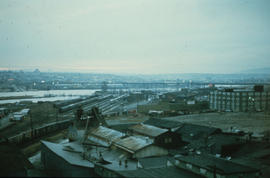
![[Southeast view from the top of the old Hotel Vancouver]](/uploads/r/null/1/5/15ba74b0c21b3c68df50b4e0a0c7c7664d37525eabb1899ab8db6eae2fef35b9/6cdcd0a1-c54d-47ed-9fa0-a6fd3992e788-A21941_142.jpg)
[Southeast view from the top of the old Hotel Vancouver]
Part of Walter E. Frost fonds
Photograph shows the Canadian National Railway Station, Georgia Viaduct, Beatty Street Armoury, B.C.E. R. gas tank, the spire of St. Andrew's Chruch and False Creek.

Part of Major Matthews collection
Panoramic view showing the Granville Bridge with the span open, C.P.R. Trestle Bridge, Robertson and Hacket Sawmill, Canadian Pipe Co., Vancouver Granite Co. and Marpole Coal Co.
![Sweeney Cooperage [Ltd.]](/uploads/r/null/3/e/3e7df79a73f3552787b2ac8a56721336248cde70ec43b3805c3d4ef95fac37be/a26dc3db-7c95-4350-ba74-fd154c1e8ffd-A59354_142.jpg)
Part of City of Vancouver fonds
Photograph also shows the Sun Tower (100 West Pender Street) and the Dominion Building (207 West Hastings Street)

Vancouver From The Lee Block. Corner Broadway and Main Street
Part of Major Matthews collection
Photograph shows Mount Pleasant Public School, False Creek, The Cambie Street Bridge.
![[Vancouver history and Vancouver in the 1930s]](/uploads/r/null/1/1/1112426/1a9be229-5f41-40b2-ae6b-d9d6f7819c8d-V00101_142.jpg)
[Vancouver history and Vancouver in the 1930s]
Part of City of Vancouver Archives sound recording and moving image collection
Item is a documentary film documenting a history of Vancouver using historical photographs, maps and records as well as street scenes of Vancouver in the 1930s. The historical portions of the film contain footage about the pioneers of Vancouver including Captain George Vancouver, John Morton (first resident of what was to become the City of Vancouver), Mr. Wm. Evans (engineer on the first transcontinental train into Port Moody), Lord Granville, John Robson, Richard Earl Howe, Admiral, and Sir Harry Burrard Neale. The film also contains footage of a map of First Narrows, Burrard Inlet, English Bay and nearby Government reserves as well as a map of False Creek, the West End and the East End. In addition there is footage of Hastings Mill (1887), Gastown (1887), the heart of the city (1884), the 1886 fire, City Hall after the fire, the CPR (1887), Indian ranches on Lost Lagoon, clearings near Stanley Park, Vancouver in 1888 and 1890, the entrance to Stanley Park (1890), as well as city scenes of Vancouver in the early twentieth century.
![Vancouver Iron [and Engineering] Works [Ltd. at 1155 West 6th Avenue]](/uploads/r/null/e/6/e6a863f6dac21b50be8367e8e5750691baffa19601e5c20b94bf689cebc0c652/bef90d24-f0c4-4d0d-b5fc-0b7d2650917e-A59351_142.jpg)
Vancouver Iron [and Engineering] Works [Ltd. at 1155 West 6th Avenue]
Part of City of Vancouver fonds
![Vancouver Iron [and Engineering] Works [Ltd. at 1155 West 6th Avenue]](/uploads/r/null/6/b/6be9697c52433ad1920fd5e29cb57959e27c9ecca3baa1946998a8ac3bce7fa1/6627b3c4-5254-4eae-b655-7375303a79e4-A59355_142.jpg)
Vancouver Iron [and Engineering] Works [Ltd. at 1155 West 6th Avenue]
Part of City of Vancouver fonds
Photograph also shows the Granville Bridge

Vancouver, B.C. From The Lee Block July 7-1913
Part of Major Matthews collection
Photograph shows Mount Pleasant Public School, False Creek, Downtown and the Cambie Street Bridge.
![[View looking north from False Creek] Photo Taken on June 1st, 1916. Time 1232. Tide 0.4](/uploads/r/null/0/9/097e130b0ecc9fbef37bf311ffdd758bccf2be3c8257c27db29e92563f1978b4/c9901857-d939-4ff0-9314-e350d7e4c9fb-A63477_142.jpg)
[View looking north from False Creek] Photo Taken on June 1st, 1916. Time 1232. Tide 0.4
Part of Major Matthews collection
Photograph shows construction of Granville Island, Granville Bridge and Cambie Bridge.
![[View looking south from False Creek] Photo Taken on June 1st 1916.Time 1140. Tide 0.4.](/uploads/r/null/a/e/aed4784758988849388cd8a8825df6b5e02879445ce3fe8c0cd9d73201329ef0/67b3e89d-dcb9-450f-a95b-0008384c611d-A63476_142.jpg)
[View looking south from False Creek] Photo Taken on June 1st 1916.Time 1140. Tide 0.4.
Part of Major Matthews collection
Photograph shows the south shore of False Creek, houses and builidings in Fairview Slopes, the construction of Granville Island, Granville Bridge and the Kitsilano Trestle Bridge.
![[View of buildings at the north end of the G.N.R. trestle bridge at the east end of ] False Creek](/uploads/r/null/0/6/0646f83230067a1dcdda83247d2ada2ebab61ab3819ee174cc8a67676e7defbc/b56bcafa-c3a0-46ed-b97c-999ada719740-A70779_142.jpg)
[View of buildings at the north end of the G.N.R. trestle bridge at the east end of ] False Creek
Part of H.A. Price collection
![[View of Downtown from the Vancouver Iron and Engineering Works Ltd. at 1155 West 6th Avenue]](/uploads/r/null/3/1/318625c5a9ad983f92e59fa31c7055a196f7feb179dd8dffcedae145a36c5cc5/52732964-6835-4d57-9a91-a7816c96cea0-A59350_142.jpg)
[View of Downtown from the Vancouver Iron and Engineering Works Ltd. at 1155 West 6th Avenue]
Part of City of Vancouver fonds
Part of Major Matthews collection
Panoramic view showing the dredging of False Creek for the Granville Island construction.
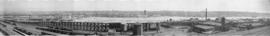
![[View of False Creek Flats east of Main Street]](/uploads/r/null/2/2/22ae18e3c70f3b175e8da170286e28bec8b9c5badf5f7209cd805214ba4c2778/0054a24e-3793-409f-a191-486d3c0e0479-A63167_142.jpg)
[View of False Creek Flats east of Main Street]
Part of Major Matthews collection
Panoramic view showing the start of the False Creek reclamation, the Great Northern Railway Station construction site, the Main Street bascule bridge, Market Hall and Ivanhoe Hotel.
![[View of False Creek looking east from the Burrard Bridge]](/uploads/r/null/8/4/84922323cf591c851fbd4ab5489c940a600fdeb6911c11e122f77b8c798c04a2/5a3406ee-9419-4ebd-bd85-d51cecb6e953-A03428_142.jpg)
[View of False Creek looking east from the Burrard Bridge]
Photograph shows the Kitsilano Trestle and Granville Bridges
![[View of False Creek looking north from 12th Avenue and Oak Street]](/uploads/r/null/0/4/049a62f5986b294c107664ef819fc7ee441a93066f4230802ac78373ff9c2bb3/a2675ba1-4bfa-41ed-9574-0ad9c213da88-A20539_142.jpg)
[View of False Creek looking north from 12th Avenue and Oak Street]
Part of James Luke Quiney fonds
![[View of False Creek looking north showing Connaught (Cambie Street) Bridge]](/uploads/r/null/8/1/815bb733e4089f8751bb890c421ea1148d0be1e25a3b0b6f19729fd28e7e1e21/26186219-e90b-47d5-a07b-6446f4fca9df-A20538_142.jpg)
[View of False Creek looking north showing Connaught (Cambie Street) Bridge]
Part of James Luke Quiney fonds

Part of Major Matthews collection
Panoramic view showing Granville Street Bridge, C.P.R. Kitsilano Trestle, and the Kitsilano Indian Reserve.
![[View of False Creek showing Granville Island and the Fairview waterfront]](/uploads/r/null/4/2/423d09208aeefd27222da460ea6826eee0597876cc74ac7c9bb3fe5624d3b5c0/a526f354-239a-41f1-a3ed-a70ca1cdf66e-A63472_142.jpg)
[View of False Creek showing Granville Island and the Fairview waterfront]
Part of Major Matthews collection
