
Sheet A : University Endowment Lands to Imperial Street and waterfront to Fifth Avenue
- AM1594-MAP 779-: MAP 779.26
- Item
- [ca. 1935], with revisions to Nov. 22, 1943
Part of City of Vancouver Archives technical and cartographic drawing collection
Item is a section showing the area from the University Endowment Lands to Imperial Street and waterfront to Fifth Avenue. Includes streets, roads and sewers; blocks, lots and legal descriptions; and parks.
Vancouver (B.C.). Office of the City Engineer


![Plan of district lot boundaries, City of Vancouver, B.C. [index map]](/uploads/r/null/9/4/9469805f0ad98fa8c476e2fa1bd641a165448bbfe6840da2ca337894637001a4/9199ff56-1884-4c1f-8d1c-1a513de71a3d-MAP779_142.jpg)


![Map of City of Vancouver, British Columbia [index map]](/uploads/r/null/b/e/be22a39bcaa01b0f0dd6d2209e1cb4ee3e1df2f15c6c663490403764c2eba017/98bf421f-34d4-4017-9cfd-a46b85bfefa8-MAP343_142.jpg)
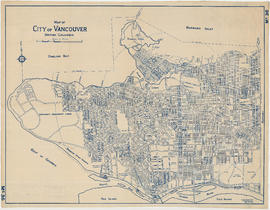
![Map of City of Vancouver, British Columbia [index map]](/uploads/r/null/b/4/b4070d13913e90841a24384f7c94ab9f22595ff9bde62429edb46fd5ed60a75a/f4bb676f-1639-4811-82bf-2a0d4defd87e-MAP779_142.jpg)
![City of Vancouver, British Columbia [index map]](/uploads/r/null/d/4/d4fc7ef393680c6515927aa960de863e6fd9e846c3fac12499691549673dc4b7/eed36b0b-2e63-48f2-a7ee-02ed3de937b9-MAP682_142.jpg)


