Street map of Greater Victoria, B.C., map cover, and street index of Greater Vancouver
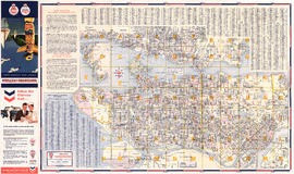
Street map of Greater Vancouver, B.C.
Street map of Greater Vancouver, B.C.
Street Map of Greater Vancouver, B.C.
Street map of Greater Vancouver, B.C.
Street map of Greater Vancouver showing distances from Bekins building
Street map of Greater Vancouver : map cover, street index and advertisements
Street Map of Greater Vancouver
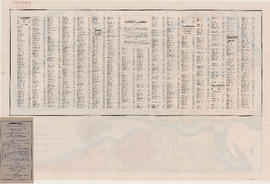
Street index (Royal Oak Avenue, Vancouver to Frederick Road, North Vancouver)
Street index of Vancouver and lower mainland
Street index of Vancouver and Lower Mainland
Street index (Gibson Street to William Street) and tram stations
Street index (Campbell Street to Rosser Avenue)
Street index
Street index
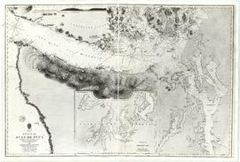
Strait of Juan de Fuca
Stanley Park, Vancouver, B.C.
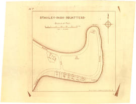
Stanley Park squatters
Stanley Park [Golden Jubilee]
Stanley Park
Stanley Park
Stanley Park
Standard tourists' guide to Stanley Park, Vancouver, B.C.
Southern British Columbia showing disposition of lands within the Railway Belt
Southerly portion. Vancouver Island
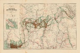
South Western Districts [of British Columbia]
South Vancouver
Sketch showing traffic plan for night functions in Stanley Park during Golden Jubilee period
Sketch plan of the mouth of the Saskatchewan River, from Hinds Exploring Expedition
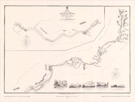
Sketch of the upper part of the Fraser River from Langley to Yale
Sketch of proposed interurban canal and harbour development for Greater Vancouver, B.C.
Sketch of part of proposed line of waggon [sic] road from "Boston Bar" to "Yale" on left bank of "Fraser River"
Sketch of part of line of waggon [sic] road from "Boston Bar" to "Yale"
Sketch of part of line of road along right bank of "Fraser River" from "Boston Bar" to "Yale"
Sheet Z : Milton Street to Heather Street and Seventy-second Avenue to Fraser River ; Angus Drive to Granville Street and South West Marine Drive to Fraser River
Sheet X : South West Marine Drive to Ash Street and Fifty-ninth Avenue to Seventy-first Avenue
Sheet X : Marine Drive to Ash Street and Fifty-ninth Avenue to Seventy-first Avenue
Sheet W : Fraser River to French Street and Fifty-ninth Avenue to Seventy-first Avenue
Sheet W : Fraser River to French Street and Fifty-ninth Avenue to Seventy-first Avenue
Sheet V and Z : Milton Street to Heather Street and Seventy-second Avenue to Fraser River ; Angus Drive to Granville Street and South West Marine Drive to Fraser River
Sheet U : Churchill Street to Cambie Street and Forty-ninth Avenue to Park Drive
Sheet U : Churchill Street to Cambie Street and Forty-ninth Avenue to Park Drive
Sheet T : Marine Crescent to Granville Street and Forty-ninth Avenue to Sixty-first Avenue
Sheet T : Larch Street to Granville Street and Forty-ninth Avenue to Sixty-first Avenue


![Stanley Park [Golden Jubilee]](/uploads/r/null/2/4/24135e2d726e60ffbc74f0d81c3a53d51a38fe9ea1e86ecda92708249adac23b/1b46df5d-6871-41b2-b1dd-91a0c1d5ad02-MAP624_142.jpg)


![South Western Districts [of British Columbia]](/uploads/r/null/d/0/c/d0ceafbed0c6a061cca38316066e937eb832289e737bebc70e29bbbd8db278b4/9724c086-f8fa-4751-8cfe-808fa27e04d2-MAP115_142.jpg)


![Sketch of part of proposed line of waggon [sic] road from "Boston Bar" to "Yale&qu...](/uploads/r/null/c/e/2/ce2401c4feac301ae2c09b558486e5d36c42075bdbdb34d93491fb38bf94199b/a0d055f2-d790-4fc6-b0aa-1572524f65c8-LEG1800_142.jpg)
![Sketch of part of line of waggon [sic] road from "Boston Bar" to "Yale"](/uploads/r/null/6/8/5/685aeba6eb70cf489e3dc55456603ed30b0d42c00326cb69f8eb8fa758e030aa/714b3ee8-af5a-4786-85f4-230287a8d5fa-LEG1800_142.jpg)


