
- AM54-S4-: Air P94
- Item
- Aug. 18, 1955
Part of Major Matthews collection
Oblique view. Photograph shows Coal Harbour, H.M.S.C. Discovery, Royal Vancouver Yacht Club marina, Rowing Club marina, Brockton Oval and the Burrard Inlet waterfront.
1079 results with digital objects Show results with digital objects
Part of Major Matthews collection
Oblique view. Photograph shows Coal Harbour, H.M.S.C. Discovery, Royal Vancouver Yacht Club marina, Rowing Club marina, Brockton Oval and the Burrard Inlet waterfront.

Part of Major Matthews collection
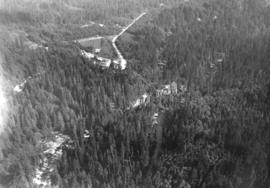
![[Aerial view looking south-west of the] District of North Vancouver](/uploads/r/null/a/b/ab2ec4570d14f519cdac8220126fd3bf21b20665ef1313681e9bbfbb2e1dd1c5/69236007-852b-4154-94da-29459b1bc14a-A23495_142.jpg)
[Aerial view looking south-west of the] District of North Vancouver
Part of Major Matthews collection
Oblique view. Photograph shows Fern Street overpass, Bridgeman Park, Lynn Creek and Moodyville.
![[Aerial view looking south of the] District of North Vancouver [between Seymour and Lynn Creeks]](/uploads/r/null/e/f/efec87eb86f83a0865fb63dd855e51942b3f5e6b75c5f105b15ef3db57d5b5c9/107091fb-3414-4f25-bc79-e59cee44fbab-A23496_142.jpg)
[Aerial view looking south of the] District of North Vancouver [between Seymour and Lynn Creeks]
Part of Major Matthews collection
Oblique view. Photograph shows Second Narrows, old and new Second Narrows Highway bridge, Indian Reserve No. 2 and Maplewood.
![[Aerial view looking north-east of the] District of North Vancouver](/uploads/r/null/9/5/95a056a0d3b5e734a0ac2527276ac4aca69e5dade031eb57596c7d359c95cdc4/50dcb21d-5cb6-41b7-ba47-eab3470af912-A23497_142.jpg)
[Aerial view looking north-east of the] District of North Vancouver
Part of Major Matthews collection
Oblique view. Photograph shows Deep Cove, Dollarton, Sherwood Park subdivision, Keith Road and Indian Arm.
![[Aerial view looking west of the] District of North Vancouver](/uploads/r/null/9/5/958342bfc158583761e59a85838c811fc69beaa535cf44a6a97fc6da0b2b9fec/fc695e17-8926-494e-b8d0-bef82af0912c-A23498_142.jpg)
[Aerial view looking west of the] District of North Vancouver
Part of Major Matthews collection
Oblique view. Photograph shows Marine Drive from MacKay Creek to Capilano Indian Reserve No.5, Kiwanis Senior Citzens housing, Avalon Hotel, Dominion store and the Norgate Park subdivision.
![[Aerial view looking south-west of the] District of North Vancouver](/uploads/r/null/0/d/0d8adb3b55d68b7df4c4925829b8ff3b87c6f13f3a1ec81d303a4854c57064b0/0e67b80d-8372-4feb-93c5-e9c63b1d4541-A23499_142.jpg)
[Aerial view looking south-west of the] District of North Vancouver
Part of Major Matthews collection
Oblique view. Photograph shows Norgate waterfront, P.G.E. yards and sheds, L & K Lumber, Vancouver Wharves Ltd. and Stanley Park.
![[Aerial view looking west south-west of the] District of North Vancouver](/uploads/r/null/e/c/ec241a495ce73acb4df544a3511e33bf47855c3f9780f6fdf330d5e1998b35f4/4b33b03c-3b2c-434d-877d-de90ed039d2a-A23500_142.jpg)
[Aerial view looking west south-west of the] District of North Vancouver
Part of Major Matthews collection
Oblique view. Photograph shows Deep Cove, Panorama Park, Deep Cove Yacht Club, Public Wharf (foot of Gallant Avenue), Deep Cove Resorts and Deep Cove Park.
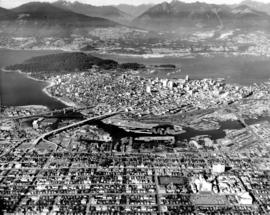
Vancouver from the air looking north from over Little Mountain
Part of Major Matthews collection
Oblique view. Photograph shows Fairview, False Creek, R.C.A.F. Equipment Depot, Granville Island, Burrard Bridge, Granville (Street) Bridge, Downtown, West End, Stanley Park, Vancouver General Hospital, First Narrows and Burrard Inlet.
![[Aerial view looking north of the] Vancouver Wharves Ltd.](/uploads/r/null/a/3/a3e50a2d6a7688fca44a9f2fae2ec7ad724640047b3512a075ae83d4e5a3378e/ce172262-4f02-498d-ab6c-e23b06e50b09-A23502_142.jpg)
[Aerial view looking north of the] Vancouver Wharves Ltd.
Part of Major Matthews collection
Oblique view. Photograph shows P.G.E. yards, L & K Lumber, Norgate waterfront and West Vancouver.
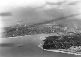
![[Aerial view of] International Peace Arch Blaine - Wash.](/uploads/r/null/9/1/91068d22bc7764c5f5aa03830dd646b5117bdf978a996f0eabec7f14d28285aa/e10f789c-db7d-475e-90fd-638864474d36-A23579_142.jpg)
[Aerial view of] International Peace Arch Blaine - Wash.
Part of Major Matthews collection
Oblique view. Photograph also shows the Canadian border crossing and custom's buildings and the American custom's building.
![[Aerial view of Kitsilano Beach]](/uploads/r/null/0/4/04933fd0b52b1825a12ac427f70fb35dc469232064c8156168d851093d1ae411/05361ecf-adfc-4cdc-be95-07157d2e9dd1-A23610_142.jpg)
[Aerial view of Kitsilano Beach]
Part of Major Matthews collection
Oblique view.
![[S.S. "Chilcotin" in Devestation Channel]](/uploads/r/null/3/1/31fee18f1a65b8c477904c06780b3c3821c1d46086039885c3bf92e6f0098aa0/749c2538-35ff-4854-a513-b2045cd8027e-A24285_142.jpg)
[S.S. "Chilcotin" in Devestation Channel]
Part of Major Matthews collection
oblique view
![[View of "Fram" house, museum and surroundings]](/uploads/r/null/a/2/a23e8d90b582fc81e46113cc01d88737de674f1b6fa6bd8e12e6c3893b9f57b8/57d1f05c-1c0a-46d2-bb67-76183b1f96d8-A24329_142.jpg)
[View of "Fram" house, museum and surroundings]
Part of Major Matthews collection
Oblique view.
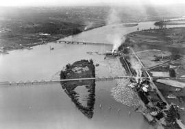
![[Agassiz-Rosedale Bridge]](/uploads/r/null/b/9/b9a0eb51c46b2d4d18d17731a36fa41612fd8d34f153433851eda3dd6d55e728/ab733b8f-00dc-42e4-bf26-7ef4383180bb-A24439_142.jpg)
![[Northern view of Oak Street bridge under construction]](/uploads/r/null/3/c/3ce95649becd6661bfb266e929ef9f7f0fb0047a4e0c644d3975486d3b9ddc9c/cf895488-0c64-458d-913c-9deac49a536c-A24440_142.jpg)
[Northern view of Oak Street bridge under construction]
Part of Major Matthews collection
Oblique view shows the Marpole rail and highway bridges.
![[View of the Oak Street, B.C. Electric and Middle Arm bridges]](/uploads/r/null/8/d/8d4f4dea792a3128229aecfd55a12d3a3432476462ad8cd9991e1ebb16cae075/62c52137-d9af-48bd-a8bc-2a12293b382d-A24441_142.jpg)
[View of the Oak Street, B.C. Electric and Middle Arm bridges]
Part of Major Matthews collection
oblique view
![[View of the Marpole rail and highway bridges]](/uploads/r/null/3/9/39d081635b9fd32192951910755276ab7921e8ca55e3206da51189c0b65a8080/015c04a5-11d7-4d15-95ab-e794ef8e9f32-A24442_142.jpg)
[View of the Marpole rail and highway bridges]
Part of Major Matthews collection
Oblique view shows Vancouver International Airport.
![[View of Oak Street, Marpole rail and highway and Middle Arm bridges]](/uploads/r/null/4/1/4199f99a2a9078cbea68581cb0c930996461009cc1719feede4e449ea5a2379d/94cbe073-4e30-45d0-baea-1b0cb58d69b4-A24443_142.jpg)
[View of Oak Street, Marpole rail and highway and Middle Arm bridges]
Part of Major Matthews collection
Oblique view.
![[Collapse of Second Narrows bridge during construction]](/uploads/r/null/7/b/7b1b0ec0cf16f91f2f421656c37e2edaa449477a299e7b2ac3df0109763f7707/a9342f72-46ec-44d5-bf84-fde7dc22a42a-A24446_142.jpg)
[Collapse of Second Narrows bridge during construction]
Part of Major Matthews collection
Oblique view.
![[Aerial photograph of the Alberta Wheat Pool elevators and shipping gallery]](/uploads/r/null/3/2/32dabc19b9a47ef8b896d54d0659490566097669fc4b47d2f53556b539abddda/989f5b86-0587-4af2-9362-01b4eea2b5d7-A25116_142.jpg)
[Aerial photograph of the Alberta Wheat Pool elevators and shipping gallery]
Part of Major Matthews collection
Oblique view shows the New Brighton Pool
![[Aerial view of City of Vancouver, image of printed photograph]](/uploads/r/null/8/0/3/80337fd039988f10176eb1c593eb6cacff2aceac861957b1ea4b7be13e8b5ce7/1bdf7acc-f42b-4f15-bd32-4d7c837f7829-CVA1095-06993_142.jpg)
[Aerial view of City of Vancouver, image of printed photograph]
Part of City of Vancouver fonds
![[Aerial view of City of Vancouver, image of printed photograph]](/uploads/r/null/7/0/d/70d11e62ad0119a7483a61fe5f3229fcc4e1aacd651e6722db2466c5a80a8dcb/35b64a80-d60d-4551-89eb-87a5b81ac347-CVA1095-06994_142.jpg)
[Aerial view of City of Vancouver, image of printed photograph]
Part of City of Vancouver fonds
![[Aerial view of City of Vancouver, image of printed photograph]](/uploads/r/null/f/3/2/f3234fb45e4f46831886bd2cb6694f50a56ee898e4f2bd5b62dac4912067f52e/e5d60571-6952-41a6-8a5f-aba132b36f28-CVA1095-06995_142.jpg)
[Aerial view of City of Vancouver, image of printed photograph]
Part of City of Vancouver fonds
![[Aerial view of City of Vancouver, image of printed photograph]](/uploads/r/null/3/b/6/3b6df85f34e645db70d12e261cd1a8c0cea08edc95e2716ce32a92dc881a5878/efd40a47-faf5-435c-8b80-2f9099c88723-CVA1095-06996_142.jpg)
[Aerial view of City of Vancouver, image of printed photograph]
Part of City of Vancouver fonds
![[Aerial view of City of Vancouver, image of printed photograph]](/uploads/r/null/a/6/5/a6568a4fca40576b2d2b079a13541a80ace37c89086c2a64db6237dfdb087262/fb145724-094b-4d2e-9a60-24df3aef9c61-CVA1095-06997_142.jpg)
[Aerial view of City of Vancouver, image of printed photograph]
Part of City of Vancouver fonds
![Race Track - [Hastings] Park](/uploads/r/null/a/e/ae3866984dbd71adb11e4f16a3faeff5c926d7d6dbc7c68bef37bbe9e34f2147/8e72031a-2c43-4d2f-ade2-eaf99cf53105-A44678_142.jpg)
Part of Stuart Thomson fonds
Oblique view showing a view looking southeast along Renfrew Street towards Hastings Street, parts of Wall Street, Trinity Street and McGill Street, the northern section of Hastings Park, the roller coaster, the Manufacturing/Industrial Building and the Exhibition Building on the Exhibition Grounds. The photograph also shows a house at 2950 Trinity Street.
Capilano Creek looking south showing Canyon View Hotel
Part of Stuart Thomson fonds
Oblique view

Capilano Valley and the Lions, Canyon View Hotel in foreground
Part of Stuart Thomson fonds
Oblique view
![[Looking East along North Shore of Burrard Inlet showing] Lyall Shipyards](/uploads/r/null/7/6/7678fa1b56c04440934da67100938dfff341a5d4c13498df784bdf7ceaa20409/5d643fec-17a2-48f6-bb2f-536d1e76a73a-A44689_142.jpg)
[Looking East along North Shore of Burrard Inlet showing] Lyall Shipyards
Part of Stuart Thomson fonds
Oblique view showing the Mission Village and church
![Grain Elevators and dock - foot of [Commercial] Drive looking east](/uploads/r/null/f/a/fa64fc2fdcd81147912c6227ac42be08f398a362ba801186b73930b6b55d9888/5fb3ff66-892d-4cce-b810-d6918a9c1aed-A44690_142.jpg)
Grain Elevators and dock - foot of [Commercial] Drive looking east
Part of Stuart Thomson fonds
Oblique view showing the Canadian Government Elevator and dock

Looking East showing Second Narrows and North Arm of Burrard (South Shore of Inlet - Hastings East)
Part of Stuart Thomson fonds
Oblique view showing sawmills
![[Minoru] Park showing track and buildings looking southeast](/uploads/r/null/6/4/648cb80afef74a65543688d3530a5fa0d34e02ce9846a15129939eea7e4998b1/d114b0d7-d9de-4451-bad0-efa589fd7bc4-A44692_142.jpg)
[Minoru] Park showing track and buildings looking southeast
Part of Stuart Thomson fonds
Oblique view
Bridges over Fraser River at Eburne
Part of Stuart Thomson fonds
Oblique view showing the Marpole (Eburne) Low Level Rail Bridge and the Marpole Low Level Highway Bridge from Sea Island and Duck Island
View of Kitsilano and False Creek
Part of Stuart Thomson fonds
Oblique view showing Kitsilano Beach, the Kitsilano Trestle and Granville Bridges and Granville Island, the West End and Downtown in the background

Part of Stuart Thomson fonds
Oblique view looking east along Broadway showing Kitsilano, the B.C.E.R. Lulu Island line, and the Kitsilano Trestle and Granville Bridges, Granville Island, Fairview, Downtown and Yaletown in the background

Looking East Along Georgia Street
Part of Stuart Thomson fonds
Oblique view showing Pacific Coast Lumber, boat builders at the foot of Bidwell Street, the West End east of Denman Street and the second Hotel Vancouver and Downtown in the background

Showing Entrance to Stanley Park looking East
Part of Stuart Thomson fonds
Oblique view showing Lost Lagoon, Coal Harbour, Deadman's Island, Brockton Point, Denman Arena, the Horseshow Building and Downtown in the background

Prospect Point Showing West Vancouver Ferry in Narrows
Part of Stuart Thomson fonds
Oblique view showing the lighthouse

Part of Stuart Thomson fonds
Oblique view showing Burrard Dry Dock and Lonsdale Avenue

Part of Stuart Thomson fonds
Oblique view

Vancouver looking north from 22nd Avenue
![[View of farm buildings and fields taken from the air]](/uploads/r/null/9/b/9b1f700b1bdee44fb2534cdd56a164987f3e8bb21e6f247ae7822623a2df94dc/7d25fb85-64f0-4eca-a154-b9f6d0bc65bf-A13721_142.jpg)
[View of farm buildings and fields taken from the air]
![[Aerial view of Vancouver]](/uploads/r/null/7/0/70fe55216d34bcc4ff4f671e2d7814e6d15c21dd5aaf76b58bc6469a40388a1d/c25263bf-0975-439c-bc93-248713d79567-A13722_142.jpg)
![[Aerial view of Vancouver showing the Fraser River]](/uploads/r/null/d/b/db0369bf59a848e9764e3b839c47c8ec7201f99a4017bbddd8512f47ca26200f/5ab47fec-a8ce-4ad4-a81e-ae2c39689e5a-A13723_142.jpg)
[Aerial view of Vancouver showing the Fraser River]
![[View of the Goodyear blimp taken from an airplane above Vancouver]](/uploads/r/null/3/3/3336881308e1e37de96b9ef201f813bbbd6e2db7aa1821f78400ef5a8deb32ff/5b651868-2938-4420-a791-777473cdb6e8-A13724_142.jpg)
[View of the Goodyear blimp taken from an airplane above Vancouver]
![[Aerial view of Vancouver]](/uploads/r/null/d/7/d7f280a1021ddedf2aae71722e35fd9ee91a1e6d3f2e31003eed6fec146e27e7/e30c0e8a-964a-484e-90db-349ad9165b2f-A13725_142.jpg)
![[Aerial view of Vancouver]](/uploads/r/null/b/6/b61e5089ec8edb824f16eea9b4373dfb3ac9ea83b052f855a90859c3a7424f4c/c7a56b73-012c-4e6d-b4e3-c362735e3a05-A13726_142.jpg)
![[Aerial view of Vancouver showing the Goodyear blimp]](/uploads/r/null/8/e/8e555d9af3baf3296446345ad718a4b310d778d587429ac7d783ddf6d0bd1a28/11f7d743-9030-4973-aec6-c44fd5ba4e7c-A13727_142.jpg)
[Aerial view of Vancouver showing the Goodyear blimp]
![[Aerial view of Vancouver showing the Goodyear blimp above the Downtown area]](/uploads/r/null/8/4/845b713451cd89bf22d1340d07a741cc7c4b68ce884237a8bf7db719fb1f8a0c/f7115108-1cb7-4a7e-b6f7-b767fbd53e1d-A13728_142.jpg)
[Aerial view of Vancouver showing the Goodyear blimp above the Downtown area]