![[View of] townsite [at] Pacific Mills](/uploads/r/null/6/8/68ed185eccdf9ab912cdfe592c5a1bbccf534ed0c0b2fd2cb2f6403b359eae3a/1d04146c-c3d0-4a5e-a781-d6df275e657c-A14781_142.jpg)
[View of] townsite [at] Pacific Mills
- AM1545-S3-: CVA 586-3449
- Item
- Nov. 1944
[View of] townsite [at] Pacific Mills
![[View of] townsite [at] Pacific Mills](/uploads/r/null/c/1/c1a22944348414406d5d0d44f48c2ba6a714665c651a822617a78113f9df8a67/228a6b5f-227a-4fd3-b128-71f0b8287581-A14780_142.jpg)
[View of] townsite [at] Pacific Mills
![Town and mill from booming grounds [at] Pacific Mills](/uploads/r/null/9/f/9faf5089eab394c796b6a8c6068bb24041ec4596502f1542a1c23c928050a01a/497b21f2-cebf-4a31-a7fc-0648b0f7eb51-A14753_142.jpg)
Town and mill from booming grounds [at] Pacific Mills
Photograph shows a Davis Raft
![[View across the water from] Sandspit [on the] Queen Charlotte Islands](/uploads/r/null/2/7/278b146d67391964b22a9a530a7518a8093c13eccb46f019936e4b70351f2f1a/d0720a1b-fe6e-4c73-9de6-8df0b6289b10-A14947_142.jpg)
[View across the water from] Sandspit [on the] Queen Charlotte Islands
![[Looking across the water from] Pacific Mills [dock on the] Queen Charlotte Islands](/uploads/r/null/2/8/287b948daf5968d243170070627b05292ccfc0f574696c223db2a8274093544c/23b71184-a2ee-44d3-b4a3-34c561b1cd98-A14906_142.jpg)
[Looking across the water from] Pacific Mills [dock on the] Queen Charlotte Islands
Photograph shows the "Alco III" from Vancouver
![[View from a] Pacific Mills [logging site on the] Queen Charlotte Islands](/uploads/r/null/7/5/75ff02caa339fcdfd97719730256158de9acc744e1ce1760d16519fd3037e70c/0b929a8d-1f49-4cf4-94eb-c9b6a8bb0543-A14880_142.jpg)
[View from a] Pacific Mills [logging site on the] Queen Charlotte Islands
![[View overlooking] Pacific Mills [logging site on the] Queen Charlotte Islands](/uploads/r/null/9/e/9e659a899df427d86cce937d8d377beb1a308cb91a92ef9d086a9b1664c06c27/d6cd8f45-83e8-47d7-a7f4-8a32e0771130-A14879_142.jpg)
[View overlooking] Pacific Mills [logging site on the] Queen Charlotte Islands
![Garibaldi Mountain [showing] Columnar Mountain in foreground](/uploads/r/null/7/a/7a807283493af89ef88093dcfdd0d493e90a1ab7fa284188f7469742e55ed884/bc950e1c-7515-4968-97f9-6ce80cbabbbb-A14811_142.jpg)
Garibaldi Mountain [showing] Columnar Mountain in foreground
![First cabin of Garibaldi Hostels [under construction]](/uploads/r/null/3/6/36fbfd7c3c8b1e784cdfb4cdf3ad89b7ad41c911ee8a399682e0fc9b8a8f2a1c/8af065dd-a87a-4fbb-b0da-86f1f5798814-A14810_142.jpg)
First cabin of Garibaldi Hostels [under construction]
Photograph shows the Mamquam Range in the background

View of Upper Howe Sound (Squamish) from Empire Mills' upper camp on way to Garibaldi Hostels
![The Black Tusk [in] Garibaldi Park](/uploads/r/null/0/f/0f42a3ad1d828a1498d595ff36b7e3a6bfb035bda959e09e2f93ced0dfc7aa46/edcc0e8c-236f-485a-b500-a31e5c9d72ef-A14807_142.jpg)
The Black Tusk [in] Garibaldi Park

Photograph shows a view looking north including the Immigration Building, C.P.R. Pier A and the Marine Building and Burrard Inlet and the North Shore in the background

Part of Major Matthews collection
Photograph shows the Marine Building, the post office clock tower and Pier B-C in the background
![Scenic [view on] Vancouver Island](/uploads/r/null/e/3/e3c4157bbd7023413f30bc06e776b41cb804f7f09eeb4a030dca40025d57e7c7/5a6b44f0-2c1a-44a8-ad3c-cd6d59b4418d-A07418_142.jpg)
Scenic [view on] Vancouver Island
Photograph shows a farm among the trees. Inscription on verso of print "Near Mission, B.C."
Steffens-Colmer notebook identifies photograph as "Scenic log fences and trees, Van. Is."
![[Looking north from Nelson Street just east of Thurlow Street]](/uploads/r/null/0/6/063e02ba53aa134b2a656b0db324beaf3a4615ec417fb2ee32d3e3e226620699/5df3a239-9da3-49b5-ae6b-d0424948719a-A02567_142.jpg)
[Looking north from Nelson Street just east of Thurlow Street]
Photograph shows houses and apartment buildings (including the Manahattan Apartments), part of Brockton Point, the Burrard Inlet and the North Shore.
![[View across the North Saskatchewan River]](/uploads/r/null/d/1/d1e0726a2ee0cc278c42e35106e5d2b6aafc8875bd97d9ee40c69edf0f4703e4/8423392c-41fa-4fa1-9d23-4f9c3b1b109b-A07240_142.jpg)
[View across the North Saskatchewan River]
Inscription on verso of print "#2515 - Saskatoon Sask. North Saskatchewan River, / University Buildings, upper right. / Don Coltman Photo"
![[Looking west across the Bow River from North Hill]](/uploads/r/null/b/6/b6dbadac3b3a5f7c01e4338b90434397e40c9261b3cecfe75d42c843e7f56a5c/ac0a92de-e4a4-40d7-8a11-8283616b3d4c-A07245_142.jpg)
[Looking west across the Bow River from North Hill]
Inscription on verso of print "#2521 Looking West .. Bow River .. from North Hill Calgary Alta."
![[View looking east from North Hill]](/uploads/r/null/8/5/8511db470a751932697ac0bd128f45f9ce8f891b2fe38b51bf4a46639f05bcaf/c413d773-a3be-4e19-9775-7ed2b146c602-A07246_142.jpg)
[View looking east from North Hill]
Inscription on verso of print "#2522 - East Calgary from the 'North End', Calgary, Alta / Don Coltman Photo"
![Scenic [view of the] Inside Passage](/uploads/r/null/4/5/451523251b96782e610d4c76f0ac95d9b2639be5085660e50fa6aa5b31d3876e/2e06d2ea-b955-46d0-ac9d-bfd98d501197-A07304_142.jpg)
Scenic [view of the] Inside Passage
![[View across the North Saskatchewan River looking west]](/uploads/r/null/3/2/3270d431b47171258bc69ea34ae78399c1968495c13fb14919d685ca616d7b0b/dca7edc8-44fa-4845-a568-65c1b3368234-A07244_142.jpg)
[View across the North Saskatchewan River looking west]
![[View across the North Saskatchewan River]](/uploads/r/null/4/4/44bb46f1ed1a0f7b2c8c56ef9bc84c3872cca5a1518c0baa89f163a8f4dddd90/5a161060-321c-41e5-90db-9f4e522d1f79-A07241_142.jpg)
[View across the North Saskatchewan River]
Photograph shows university buildings in the background
![[View of] bridge and Holy Cross Mt. near Hope, B.C.](/uploads/r/null/c/2/c285d8b9f5b8af7f7922097d09089993530fc2a717e7036ff70852a0aa7f3d6d/254672a2-4993-4d93-aadb-7ce07e20c70f-A06918_142.jpg)
[View of] bridge and Holy Cross Mt. near Hope, B.C.
![[The Burrard Bridge]](/uploads/r/null/0/5/05c95422d5df43694741f18972703078de60102bae42214ec23e03e7431a1720/6c4dce6f-5aca-4843-8e9d-c937c59d706a-A03429_142.jpg)
![[View of False Creek looking east from the Burrard Bridge]](/uploads/r/null/8/4/84922323cf591c851fbd4ab5489c940a600fdeb6911c11e122f77b8c798c04a2/5a3406ee-9419-4ebd-bd85-d51cecb6e953-A03428_142.jpg)
[View of False Creek looking east from the Burrard Bridge]
Photograph shows the Kitsilano Trestle and Granville Bridges
![[View of] Banff from [the] Alpine Clubs](/uploads/r/null/6/1/6165869500910601873a36c011125b99808b831a0103205d28793d305a01b76f/08c0c399-8201-4219-9160-c6161dcf4e6a-A07135_142.jpg)
[View of] Banff from [the] Alpine Clubs
![Turner Valley Oil [scenic view]](/uploads/r/null/f/e/fe09f263cc416550f71dc4af3fb5855810a6a2e52189855b73f3846f6f4538ab/6e812c09-daa8-44e5-b54a-91a483f78040-A07117_142.jpg)
Turner Valley Oil [scenic view]

![[View at the top] of Mt. Seymour]](/uploads/r/null/d/a/dae027646b8924703e2de2d84b7667d6ba492cd3dc47edc6c3fb3e133a4e9f75/d306ca4d-761b-4e99-b535-0c417d2216d3-A03302_142.jpg)
[View at the top] of Mt. Seymour]
![Alouet [Alouette] River](/uploads/r/null/3/3/7/337937ffadddd7589c4ed47dc69009852fdfc2f006e0b89c6170f7de4455906b/1809312a-48d9-42b5-88dd-7e946c8306f3-CVA289-002_142.jpg)
Part of William Orson Banfield fonds
![Alouet [Alouette] River](/uploads/r/null/7/1/6/716744cfd76cf513da4c8c9d917feeb44b6d23de7a91241c603c5b1e9947e619/2eaa907b-05a3-4b67-b572-a1c468e1623e-CVA289-002_142.jpg)
Part of William Orson Banfield fonds
![Alouet [Alouette] River](/uploads/r/null/5/1/d/51de637e1a4a2ca13100cfa794f473602dbc32768e3d3e61ef3cd285e19c3e1e/464b66eb-b665-499f-a123-311af67a30c5-CVA289-002_142.jpg)
Part of William Orson Banfield fonds
![On the bank of the Alouet [Alouette]](/uploads/r/null/c/3/c/c3c88e8e46778e9f1b4bc82cebfa07922e887443893f3f359933c7e94dad9c85/6fd750ba-611f-4caa-b765-63607e321433-CVA289-002_142.jpg)
On the bank of the Alouet [Alouette]
Part of William Orson Banfield fonds

![Looking south in snow [from R.W. Jackson's home at 8635 S.W. Marine Drive]](/uploads/r/null/a/6/a/a6a7f9f69b947fa0a1e3edf198ee85b701ad37e513b85e4ba6502b5afbeb1316/100f9992-e239-4388-a3e8-a1b79c9a5d51-CVA217-008_142.jpg)
Looking south in snow [from R.W. Jackson's home at 8635 S.W. Marine Drive]
Part of Robert W. Jackson fonds
![Looking south east in snow [from R.W. Jackson's home at 8635 S.W. Marine Drive]](/uploads/r/null/6/8/3/683361c433cc04b6e7f5ebf989828bbf228d5e26ad684007cce6a68312662589/38a0585f-3e03-4a3c-a0a9-811c6eb5e0e8-CVA217-007_142.jpg)
Looking south east in snow [from R.W. Jackson's home at 8635 S.W. Marine Drive]
Part of Robert W. Jackson fonds
![Prospect Point [Stanley Park]](/uploads/r/null/4/6/0/460d311a6eaa7786807e839976da63f9a70af27a5a8a2ef1131359bc93f52f64/bd734f26-7476-46e1-97d1-20e2e2cb4944-CVA294-101_142.jpg)
Part of Bertram Emery fonds
Part of Bertram Emery fonds
![V.N.H.S. camp Botanie [Valley]](/uploads/r/null/0/4/0431e88480c9273e82f28aa6b63565a8947531c63f9ae353b839114ce5cc0135/dcbbf9d0-33bc-4005-8bca-e89cc650eac5-A50760_142.jpg)
V.N.H.S. camp Botanie [Valley]
Part of John Davidson fonds
Group portrait

Part of Major Matthews collection

Part of Major Matthews collection
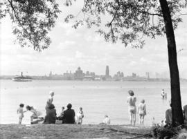
Oblique view looking east from the University Endowment Lands showing Point Grey, Dunbar, English Bay, Stanley Park, Downtown, False Creek, Burrard Inlet and North Vancouver in the background
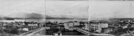
Panoramic view. Image is one of two panoramas mounted on board to show the changes in the cityscape between circa 1890 and 1923.

Panoramic view. Image is one of two panoramas mounted on board to show the changes in the cityscape between circa 1890 and 1923.
![[Aerial view of Vancouver]](/uploads/r/null/9/b/9b3acec26123edc53f11bf2f41f3286d09254ffea9918cd31b6715395ebe18d0/26473909-fe49-4474-8c3f-05eb1e8ab059-CVA1376-252_142.jpg)
Oblique view showing Fairview, Vancouver General Hospital, False Creek and the Expo 86 and other sites under development on the north side, Granville Island, Granville Bridge, Burrard Bridge, Yaletown, Downtown, the West End, Stanley Park and the Lions Gate Bridge, North Vancouver and The Lions in the background
![[View of the Burrard Bridge from Pacific Street near Thurlow Street]](/uploads/r/null/f/5/c/f5c4b5cd8e6d6316ba4112ac05f874e1c6c6a334f3f82a2921d6cfc8fea51fc8/d87a2798-5154-4d31-8aa8-2b0bb12df837-CVA371-2979_142.jpg)
[View of the Burrard Bridge from Pacific Street near Thurlow Street]
Part of Major Matthews collection
Photograph shows a view looking southeast including industrial buildings in Yaletown and squatters shacks on the water at the southwest end of the bridge
![July Moonlight looking towards the City [of Vancouver from] Bowen Island](/uploads/r/null/f/d/fd9e9c4754472d5016dd777163fab309e015a4ab5ad54f88b9b1cedf91bfce9f/71e40b9e-e948-449c-8456-092f3083cdcb-A71000_142.jpg)
July Moonlight looking towards the City [of Vancouver from] Bowen Island
Part of Major Matthews collection

Part of Hamber family fonds
Item is an amateur film documenting Mrs. E. W. Hamber and an unidentified male companion rowing a boat in wetland and Mr. E. W. with several unidentified female companions riding horses and clearing hurdles at the Hamber Minnekhada ranch in Coquitlam. The film also shows footage of a dog catching a game bird, of cattle grazing, as well as images of flocks of wild geese, and chicken and ducks at the farm.
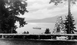
![[View of a C.P.R. "Princess" ship from Prospect Point]](/uploads/r/null/b/9/b95c66139edba33b8d0839a56f8c158700a51a4fdfb5a1148208069ccd961955/a5a8c4f1-35b5-495b-a6d4-8ce71954236c-A76095_142.jpg)
[View of a C.P.R. "Princess" ship from Prospect Point]
Part of James Crookall fonds
Photograph shows C.P.R. vessel "Princess Kathleen" or "Princess Marguerite". Photograph also shows the top of the lighthouse.
![[View of a ferry in the choppy waters of Burrard Inlet near the delta of the Capilano River]](/uploads/r/null/7/6/769a00ce4b5632d086aceddc02844682806a89e973f52022a3a55ceb4e2f224d/af13dd5b-4324-4686-a51c-7bb4611d63b9-A75991_142.jpg)
[View of a ferry in the choppy waters of Burrard Inlet near the delta of the Capilano River]
Part of James Crookall fonds
Photograph shows the Union Steamship Company's vessel "Lady Pam"
Part of James Crookall fonds