- AM54-S4-2-: CVA 371-1174
- Item
- 1958
Part of Major Matthews collection
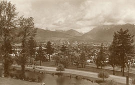
Photograph shows a view looking north from Queen Elizabeth Park. Part of a Christmas card commemorating BC's 1958 Centennial. Page of text with card
490 results with digital objects Show results with digital objects
Part of Major Matthews collection
Photograph shows a view looking north from Queen Elizabeth Park. Part of a Christmas card commemorating BC's 1958 Centennial. Page of text with card
![[Northeast aerial view of Burrard Inlet and Vancouver]](/uploads/r/null/6/6/662502a43d6839b8b0b3518a2f22ca5822fc6dc224c73d5002c705655d5ab329/48aa6304-734e-41ed-8ef2-daffdac1a38d-A23488_142.jpg)
[Northeast aerial view of Burrard Inlet and Vancouver]
Part of Major Matthews collection
Oblique view
![[Northeast view of the 600 Block Granville Street from the Hotel Vancouver]](/uploads/r/null/2/5/258d590f46742394ba22ba932f17860a3b23bbc0747b594c43aab84fe7018c87/cfc5773a-1486-4d6f-9e34-1478634a2ba2-A37115_142.jpg)
[Northeast view of the 600 Block Granville Street from the Hotel Vancouver]
Part of Major Matthews collection
Photograph shows the bandstand in the C.P.R. Park and the Bank of Montreal
![[Northern and eastern view of] Vancouver, B.C. [showing Burrard Inlet, Downtown, False Creek and ...](/uploads/r/null/a/d/ad499a709643b866df0dd06ee0db3a33d39d0fae463dc917d66f4f31c3dac3ad/05fca819-4e81-4708-982c-e3af142f77cb-A63163_142.jpg)
Part of Major Matthews collection
Panoramic view showing Coal Harbour, Deadman's Island, the Westminster Avenue Trestle and Cambie Street Bridges, St. Andrew's Church, the Beatty Street Drill Hall and the Sun Tower
![[Northern view from Downtown towards North Vancouver]](/uploads/r/null/c/4/c4e11a8eb3deeb229ed4c8539e7289a1e13542dc6ac3473728390d68502f859d/b78c1952-8208-46b9-9aab-747d52e91072-A43284_142.jpg)
[Northern view from Downtown towards North Vancouver]
Part of Major Matthews collection
Photograph shows Brockton Point
![[Northern view from the tower of King Edward High School on 12th Avenue and Oak Street]](/uploads/r/null/c/6/c6a2098e8be2096dd153388c7cc69b6590ff14fcd374b1ac1f691ebf1dc50441/abe0536e-5915-41aa-9d09-95d6c9e97be5-A47183_142.jpg)
[Northern view from the tower of King Edward High School on 12th Avenue and Oak Street]
Part of Major Matthews collection
Photograph shows part of Fairview and False Creek, the Connaught Bridge and Yaletown in the background
![[Northern view of downtown Vancouver from the World Building at 500 Beatty Street]](/uploads/r/null/c/5/c5a97982fe48806e527a2356c3596800ee386904520184558d1eb65128635907/f3ea7ce2-2a4c-40da-a5a9-2ccfa6c170b1-A63886_142.jpg)
[Northern view of downtown Vancouver from the World Building at 500 Beatty Street]
Part of Major Matthews collection
Photographs shows Central Public and Vancouver High Schools, the Dominion Bank and Vancouver Daily Province Buildings, Coal Harbour, C.P.R. Pier D and Deadman's Island and the North Shore in the background
![[Northern view of downtown Vancouver from the World Building at 500 Beatty Street]](/uploads/r/null/9/5/95cc16c6b26e463eb28bc5ac8abec9ec6723150a2aefbca7850f264a2adff766/e88985ba-abeb-4d06-8eea-2bf10a834381-A63885_142.jpg)
[Northern view of downtown Vancouver from the World Building at 500 Beatty Street]
Part of Major Matthews collection
Photographs shows Central Public and Vancouver High Schools, the Dominion Bank and Vancouver Daily Province Buildings, Coal Harbour, C.P.R. Pier D and Deadman's Island and the North Shore in the background.
![[Northern view of downtown Vancouver from World Building, 500 Beatty Street]](/uploads/r/null/9/9/997cc0ffa3d5b19d17a58c9f16a1c6f9855c9019e5f3249c78d456803ea58779/b52f219d-f015-40b1-96a6-c089ab3c8d70-A63175_142.jpg)
[Northern view of downtown Vancouver from World Building, 500 Beatty Street]
Part of Major Matthews collection
Photograph also shows Central Public School, Victory Square, Vancouver Daily Province and Dominion Bank Buildings, the Flack Block and C.P.R. Piers B and C and the North Shore in the background.
![[Northern view of Fairview from the tower of King Edward High School on 12th Avenue and Oak Street]](/uploads/r/null/b/c/bc4f34ad9aa5a5bc18dec6ca7832786f8b77217c3729cf25944c96705a9e416a/32c6ae21-a7bc-452c-89be-9f78d8c1067f-A43282_142.jpg)
[Northern view of Fairview from the tower of King Edward High School on 12th Avenue and Oak Street]
Part of Major Matthews collection
Photograph shows False Creek and Yaletown, with the first Granville Street Bridge and Burrard railway trestle in the background.
![[Northern view of False Creek Flats from Mount Pleasant]](/uploads/r/null/4/c/4c21145a751d4755607fbd86dd1a02b6124e2a5073f3f6f876110310c5fabf21/0e75cede-a8b6-49ce-9be7-a64b95a7e3dd-A43285_142.jpg)
[Northern view of False Creek Flats from Mount Pleasant]
Part of Major Matthews collection
![[Northern view of the 600 Block between Howe Street and Granville Street from the Hotel Vancouver]](/uploads/r/null/f/f/ff1346527da8addf4e4ac2a5452cecc5e7730d9cf121286a4cc5d9efa6377496/f84fd027-2319-449c-8647-d7784d865359-A43293_142.jpg)
[Northern view of the 600 Block between Howe Street and Granville Street from the Hotel Vancouver]
Part of Major Matthews collection
Photograph shows the Van Horne Block, the Japanese Consulate, the Alhambra Theatre and the Bank of Montreal
![[Northern view of the clearing of the Second Shaughnessy Heights for subdivision]](/uploads/r/null/7/8/78d8a0d2496efc7cc65dc7aa0ffc312aa8b08132be47a6b0334d00ee9b7f5d01/1d358ea8-bd9b-4d8a-8f5d-ebd80b257775-A66610_142.jpg)
[Northern view of the clearing of the Second Shaughnessy Heights for subdivision]
Part of Major Matthews collection
Panorama view showing the area between 33rd Avenue and King Edward Avenue and west of Granville Street and east of Oak Street, construction workers and in the background the construction camp, Shaughnessy School, Braemar School and Little Mountain
![[Northern view of Vancouver from Queen Elizabeth Park]](/uploads/r/null/7/4/74be239ca41d3c8e917bb89bcc04a218371dda9cbb806fabc2eac55afc5fee1e/934890e8-cf9f-47a4-a152-a07a17409a37-A43280_142.jpg)
[Northern view of Vancouver from Queen Elizabeth Park]
Part of Major Matthews collection
![[Northern view of Westminster Avenue (Main Street) from 7th Avenue]](/uploads/r/null/e/e/eedf5dc6b5cf6caafadff512ec18cf952b58c3fe76cbe821bad2890dd36af4ad/ead53220-dc8f-4f5e-9654-b6cea29e57c4-A43237_142.jpg)
[Northern view of Westminster Avenue (Main Street) from 7th Avenue]
Part of Major Matthews collection
Photograph shows the Westminster Avenue Trestle Bridge and False Creek in the background
![[Northward view of Downtown Vancouver from the tower of the Vancouver Block]](/uploads/r/null/7/e/7e88d0ca5a3c8b27417b0772731b3b9c8e8116caba7efef77325c3bfdf9ef14d/7ff76790-0eb3-4328-b584-8e7978589537-A63884_142.jpg)
[Northward view of Downtown Vancouver from the tower of the Vancouver Block]
Part of Major Matthews collection
Photograph also shows the upper floors and the roof garden of the second Hotel Vancouver, Burrard Inlet and the North Shore in the background.
![N.W. from Banfield [Bamfield]](/uploads/r/null/2/a/2ae456c2e5e80b1cf2731f536f711908e2b2cb4ff94fb8eca71a31d6cb913551/f4dbdcb0-9078-4c07-a225-553aedf191e7-A33540_142.jpg)
Part of Major Matthews collection

Part of Major Matthews collection
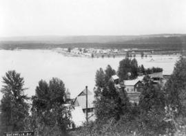
Photograph shows Dawson City in the winter

Part of Major Matthews collection
Photograph shows a aoat at dock and Deadman's Island in the background
![[Panoramic view looking north from the Hotel Vancouver]](/uploads/r/null/d/0/3/d032ae1a08ec1b68763941336f6a07708bf678235ae8cdf506cbbdc3fb10451d/98ea51ff-abce-48a9-9401-16834b8ba6a4-VanScP143_142.jpg)
[Panoramic view looking north from the Hotel Vancouver]
Part of Major Matthews collection
Photographs show the west side of the 600 Block of Howe Street, Manor House, Deadman's Island, the 600 Block of Granville Street, the Van Horne Block, the Hudson Bay Company store, the Homer Street Methodist Church, the tower of Holy Rosary Cathedral and other buildings and houses
![[Panoramic view of North Vancouver and shoreline]](/uploads/r/null/4/e/4ee696a5cca1c4399f42ab280a1134aff6d0ece1317bf5ba07c79e71586ca9ae/723aa5bf-6f5f-4030-97c8-335c11fb339a-A67014_142.jpg)
[Panoramic view of North Vancouver and shoreline]
Part of Major Matthews collection
Photograph shows Lonsdale Avenue
![[Park Road at Brockton Point under construction]](/uploads/r/null/3/0/303fb80d7dc376a51bfc34a222fa8d1715c9c8539dae04caae702b9affc039a2/141be698-5c82-413c-a4ff-e32a6e5b7a99-A36824_142.jpg)
[Park Road at Brockton Point under construction]
Part of Major Matthews collection
Photograph shows the barque "Robert Kerr" in the distance

Part of Major Matthews collection
![[People watching boats in Coal Harbour from the foot of Denman Street]](/uploads/r/null/f/3/f387e40367d782d42819f3f63c736169ab9a26f94ab6d609702e954a24818967/4df6c6ba-7230-4fd0-a791-4e5b6b52d3e5-A37356_142.jpg)
[People watching boats in Coal Harbour from the foot of Denman Street]
Part of Major Matthews collection
Photograph shows the Coal Harbour bridge
Part of Major Matthews collection

Part of Major Matthews collection
Panoramic view showing the Eburne-New Westminster electric railway tracks, a farm, railway cars and Richmond Island in the background.

Point Grey Municipality: Shaughnessy Heights from Granville Street, 1911
Part of Major Matthews collection
Panoramic view showing houses under construction including "Hycroft" and Angus Drive leading to the Crescent.
![[Point Grey Partnership Pipe project - False Creek Section]](/uploads/r/null/3/2/32a92ca46baf9d0be596bd3ef1744b7f1bb9b40366228d328bf670af8c7e124a/3e0d525d-9cce-4516-b35b-b98f22d54024-A60135_142.jpg)
[Point Grey Partnership Pipe project - False Creek Section]
Part of Major Matthews collection
Construction progress photograph looking north across False Creek from east railing of Connaught (Cambie) Bridge showing a portion of the bridge guard pier that was removed to make way for the pipe, the Musicmaster Phonograph Company and other buildings and the World Tower in the background
![[Point Grey Partnership Pipe project - False Creek Section]](/uploads/r/null/5/6/566cab6a240599fcae3de11946e307fc68c44e23b19936c6a12d709d8495ee20/68886aa1-b9fd-4245-91eb-813100a07e9d-A60123_142.jpg)
[Point Grey Partnership Pipe project - False Creek Section]
Part of Major Matthews collection
Construction progress photograph looking north across False Creek from east railing of Connaught (Cambie) Bridge showing a portion of the bridge guard pier that was removed to make way for the pipe, the Musicmaster Phonograph Company, the Canadian Fairbanks Morse Company and other buildings and the World Tower in the background

Part of Major Matthews collection

Part of Major Matthews collection
Photograph shows a small gully

Part of Major Matthews collection

Part of Major Matthews collection

Part of Major Matthews collection

Portion of Vancouver, B.C. Looking Northeast
Part of Major Matthews collection
Photograph shows a view from the Hotel Vancouver showing part of the B.B. Johnson (Johnson and Howe) Block and the east side of the 600 Block of Granville Street including the New York Block and the Bank of Montreal

Part of Major Matthews collection

Prince Rupert, B.C. looking east
Part of Major Matthews collection

Part of Major Matthews collection
Part of Major Matthews collection

Part of Major Matthews collection

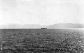
Race Rocks from Inside Channel
Part of Major Matthews collection
Part of Major Matthews collection
Panoramic view

Part of Major Matthews collection
Photograph shows a view looking southeast from the Granville Bridge towards a potential site for a billboard at Athletic Park at 5th Avenue and Hemlock Street

Saint Alice Hotel, Harrison Hot Springs, B.C.
Part of Major Matthews collection

Scene on the Saskatchewan River, N.W.T.
Part of Major Matthews collection

Sechelt Cottages - Sechelt, B.C.
Part of Major Matthews collection

Part of Major Matthews collection

Ship Passing Stanley Park, Vancouver
Part of Major Matthews collection
Photograph shows the S.S. "Charmer" near Brockton Point

Silver Mountain, Harrison Lake
Part of Major Matthews collection

Part of Major Matthews collection