![[Aerial view of trenches]](/uploads/r/null/a/b/ab8d15616a36d1b141018b1abb24bc9b7633af04528c9213c0d85d2ddc95d304/cf8ccd80-1a4e-49ea-9179-23ddad2b2b3c-A26242_142.jpg)
[Aerial view of trenches]
![[Aerial view of trenches]](/uploads/r/null/9/8/98e4d3d3322d050897616f897aa84e10566918736bd286a4a3e0f68210d50d27/218b73f6-7bfd-4bb7-9db1-f4f6b59acd0e-A26243_142.jpg)
[Aerial view of trenches]
![[Aerial view of trenches]](/uploads/r/null/e/2/e2a88aad6aada2d2871660f35735bb321f2b998fb9337c64e768d90544c8695f/d09b2c67-1102-4081-94a3-26ed65c1618c-A26244_142.jpg)
[Aerial view of trenches]
![[Aerial view of trenches]](/uploads/r/null/5/8/584843258ead325890ff73cd413aac068aba6f20635b0bdcd20da0e3d63777be/e02e8216-9601-4b7a-a44a-96fccda0826a-A26245_142.jpg)
[Aerial view of trenches]
![[Aerial view of trenches]](/uploads/r/null/6/4/64f843e33ed5333fad079749b3b9edf4d17fb6127acb95933f427bb24f9ef798/07e56ec8-9859-4840-9e38-0b3c56a78a68-A26246_142.jpg)
[Aerial view of trenches]
![[View of northern France]](/uploads/r/null/7/d/7d4b49d8d7062adedd50d8f7b29130de1917ab3d46e7f82b36ebc5723a6f6a8b/86d67be6-543f-421f-ad73-acd1a2b1a36c-A26247_142.jpg)
[View of northern France]
![[View of northern France]](/uploads/r/null/8/5/8544c51272d22c8f31381536866537fb2bf18204c2c0612a8081aa8f41a841ae/85081300-ba09-4eef-b59e-87c6ce4a1ad6-A26248_142.jpg)
[View of northern France]
![[View of northern France]](/uploads/r/null/1/9/195ad3c10a7ef65dd8ea2fb1da84894c8736ea2bec978133c9bab6b4b768c922/cc9aa259-d232-4509-a50d-c1f6e2ffe1fa-A26249_142.jpg)
[View of northern France]
![[View of northern France]](/uploads/r/null/8/0/808907a96d9e9d5e424a6bea321ab056f97b787466fc83c324c7f0475cd4aaf3/f4b7bb69-b685-47c4-85a6-09b3e9e5e27c-A26250_142.jpg)
[View of northern France]
![[View of northern France]](/uploads/r/null/a/f/af0f463af21ddd787e6c23f938bc00f60919997e8c0c1d048ab0a65ceb17ea78/f30ba0c2-0958-4216-85cb-1d6203884766-A26251_142.jpg)
[View of northern France]
![[View of northern France]](/uploads/r/null/9/1/9156113a38c3ba5ae0a1d5e11a7c785e3aaea40116f34bebee34510b1119e2a3/cb964654-f1c1-490d-8eae-4a010113eb25-A26252_142.jpg)
[View of northern France]
![[View of northern France]](/uploads/r/null/5/c/5cd7e53d89d1e99a5384f438b04e944447c24b28ef1551995b5c06062d161bfd/6c41c4e0-1845-46d5-80eb-d82876bf9feb-A26253_142.jpg)
[View of northern France]

Map of the southwestern part of British Columbia

False Creek reclamation. Suggested treatment in front of C.N.R. and Gt.N.R. passenger stations

Plan of highway paralleling V.V. and E. Railway through D.L. 264A. City of Vancouver, B.C.

Vancouver and suburbs trolley and feeder map

Vancouver and suburbs trolley and feeder map

Plan of Burrard Peninsula - distribution of population estimated for 1950

Lady Willingdon at B.C. Chamber of Mines
![[Plan of Okanagan Falls, Osoyoos Division, Yale District, B.C.]](/uploads/r/null/1/4/14f7ff1b44b8fd9998e06253c5bac0abff2ea4d9c62fdc769513da44cfbe537c/60dd23b5-52cc-455f-aa16-4d4cc49252b2-A04137_142.jpg)
[Plan of Okanagan Falls, Osoyoos Division, Yale District, B.C.]

City of Vancouver Waterworks Department. Profile of Capilano and Seymour Creek water mains

Vancouver Waterworks Dept. Capilano and Seymour water sheds

Map showing Klondyke and Indian River mining divisions of the Yukon

The East Kootenay Power and Light Co. Ltd. Triangulation survey of portions of East Kootenay. Plan showing position of mineral monuments.

[Photograph of artist's conception of a bird's eye view of a proposed Union Steamship's Resort Development on Bowen Island]
![[Promotional hand-drawn] map of Savary Island with the things to do there illustrated](/uploads/r/null/a/1/9/a19ebb0028865f62a8c02ae3586c253ba275d0e9b912dda5d91b399d84194891/13408144-e8d4-4f3c-95dd-25139fe5ca25-CVA374-435_142.jpg)
[Promotional hand-drawn] map of Savary Island with the things to do there illustrated
![[Map of Bowen Island published by Union Steamship]](/uploads/r/null/1/8/f/18f1043daafe5cb69860f22405d535dc1d284ee0b3fde9d7b6e4f16a032a55b5/799e6b15-e640-4419-989a-9a66b1d9c33f-CVA374-483_142.jpg)
[Map of Bowen Island published by Union Steamship]
![[Chart showing location of fires on map of Vancouver]](/uploads/r/null/b/5/6/b560fe6a3859a7729e70fbf616b3c70e17b61cd4a7706e3c0d936351d8608f6e/6412f5dc-25b6-4c53-adfb-97e200b22907-CVA354-325_142.jpg)
[Chart showing location of fires on map of Vancouver]
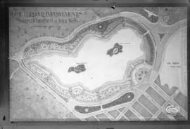
Coal Harbour Improvements Suggested Treatment of Inner Basin
![[Map of Stanley Park]](/uploads/r/null/d/d/3/dd322a6761f1b4f031344f1ff63d5db1c74e4762d10a3efb119a67a8e9bd90af/27af3243-6183-4b63-b514-1415597e6c47-CVA1095-00630_142.jpg)
[Map of Stanley Park]
![[Map of Stanley Park]](/uploads/r/null/9/2/f/92ff8e1d7d8890828829d6788574db4cda7b423aaa317ef08ec8594f81157c1e/ef3ec69f-74f3-440a-a83a-2097cfe0333b-CVA1095-00631_142.jpg)
[Map of Stanley Park]
![Miscellaneous [65 of 130]](/uploads/r/null/d/9/d990a9299a9eeabca0e0be69e111fab9ae4394e8a51b1569141b348527334a00/7a1c7f8d-6bea-465a-ada0-9cd7dda26934-A64398_142.jpg)
Miscellaneous [65 of 130]

City of Vancouver : land use 1984

Existing service stations, retail shopping centres and commercial zoning : a basis for regulating location of service stations
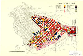
Land use - 1954

Zoning Map: City of Vancouver, British Columbia

Zoning Map: City of Vancouver, British Columbia

Zoning Map: City of Vancouver, British Columbia

Zoning Map: City of Vancouver, British Columbia

Zoning District Plan : City of Vancouver, British Columbia

Zoning map : City of Vancouver, British Columbia
![Zoning map : City of Vancouver, British Columbia [front side]](/uploads/r/null/d/f/df6282b6329852b263c3d33e20d903e4289eec05fde21bd58597f62d30789dde/225b2095-0e64-4986-878c-fd99eb6e1f18-PD2100_142.jpg)
Zoning map : City of Vancouver, British Columbia [front side]
![Zoning map : City of Vancouver, British Columbia [verso]](/uploads/r/null/8/e/8e44e80ba947d96b0a59a2bf4a48b60a1421fd04ba8480ddd13d7d13d0702e36/6b887f4f-8b76-48e2-866b-15499f569972-PD2100_142.jpg)
Zoning map : City of Vancouver, British Columbia [verso]
![Zoning map : City of Vancouver, British Columbia [front side]](/uploads/r/null/c/6/c61049cff53ecb5ec71dcc9b9de797d324126efb9c99b5eb62ea91c42d3b6842/743a013c-68a0-418f-8c6a-fd776aa116ef-PD2100_142.jpg)
Zoning map : City of Vancouver, British Columbia [front side]
![Zoning map : City of Vancouver, British Columbia [verso]](/uploads/r/null/0/c/0c28eac99426ce4ba64e4dfd48e45082c152014d6316047710a9601978663e70/d7052696-ccd5-4643-98d6-5e29205d9903-PD2100_142.jpg)
Zoning map : City of Vancouver, British Columbia [verso]

Zoning map : City of Vancouver, British Columbia

Historical park development