
- AM1435-: CVA 1435-656
- Item
- [196-?]
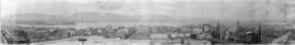
Item is photograph showing an aerial view downtown Vancouver looking northwest towards Coal Harbour and Stanley Park.
462 results with digital objects Show results with digital objects
Item is photograph showing an aerial view downtown Vancouver looking northwest towards Coal Harbour and Stanley Park.
![[South side of Coal Harbour at low tide with four-man scull]](/uploads/r/null/5/d/5d701a946729d7f820e43fd05966163d0f63a80eebee16e404fb12ca24cb73f7/1d70962a-414f-40fe-8b16-3cfc609c2393-A20515_142.jpg)
[South side of Coal Harbour at low tide with four-man scull]
Part of James Luke Quiney fonds

Showing Entrance to Stanley Park looking East
Part of Stuart Thomson fonds
Oblique view showing Lost Lagoon, Coal Harbour, Deadman's Island, Brockton Point, Denman Arena, the Horseshow Building and Downtown in the background

Part of James Luke Quiney fonds
![[View of Avalon Harbor at Santa Catalina Island]](/uploads/r/null/d/f/df0c029ba2b136ed552f01672979bc7f99aa8f69654812e869a742485f26bd0f/b48b0662-55fd-4b82-804d-e4f46a0f75cb-CVA1477-512_142.jpg)
[View of Avalon Harbor at Santa Catalina Island]
Part of L.D. Taylor family fonds
Bird's eye view
Part of Stuart Thomson fonds

Part of Stuart Thomson fonds
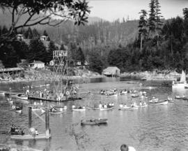
![Vancouver Rowing Club regatta [in Coal Harbour]](/uploads/r/null/c/c/cc532fdff705de55bc0b6842e761be540ea0502006d93ba757a04bdcf43c0754/7efba8d0-fa54-4a22-8c96-2f89d7bbe641-A00747_142.jpg)
Vancouver Rowing Club regatta [in Coal Harbour]
Part of Stuart Thomson fonds
The Denman Arena is featured in the background.
![Vancouver Rowing Club regatta [in Coal Harbour]](/uploads/r/null/0/d/0dacb294e11c83a59dd81a3f85afad90b131541a64d484e91988767486e25957/83fcf926-ff85-4332-abce-dcdf93f7b676-A00749_142.jpg)
Vancouver Rowing Club regatta [in Coal Harbour]
Part of Stuart Thomson fonds
Photo shows men in canoes with arena in background.
![Vancouver Rowing Club regatta [in Coal Harbour]](/uploads/r/null/a/e/aea8be199ec45ccdd094f8522d641eeb65f1727a99257a6fd819f5fc1a238747/07b65312-a17f-4a09-a8ad-6f5d06c86828-A00750_142.jpg)
Vancouver Rowing Club regatta [in Coal Harbour]
Part of Stuart Thomson fonds
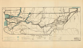
Lower Mainland Regional Plan : harbour areas
Part of Community Planning Association of Canada, British Columbia Division fonds

Part of City of Vancouver Archives technical and cartographic drawing collection
Item is a map showing major landmarks, railway lines, harbour lands reclaimed, proposed wharves and piers, retaining walls and dredging, and soundings in fathoms in Vancouver Harbour (Burrard Inlet) and False Creek.

Plan of the City of Vancouver, B.C.
Part of City of Vancouver Archives technical and cartographic drawing collection
Item is a map of the old City of Vancouver south to 16th Avenue. The map depicts District Lots and blocks, railway lines, street car lines, industrial areas, parks, postal information, schools, property boundaries.

Vancouver Harbour, British Columbia, 1932
Part of City of Vancouver Archives technical and cartographic drawing collection
Item is a nautical chart showing English Bay and Burrard Inlet with soundings in feet, anchorages, locations of submarine cables, and ferry lines. Land features include city blocks and district lot numbers. Includes inset maps of the North Arm of Burrard Inlet and Vancouver Island.

Vancouver Harbour. British Columbia
Part of City of Vancouver Archives technical and cartographic drawing collection
Item is a map sheet containing three nautical charts. The main map shows English Bay and Burrard Inlet and the land bordering these bodies of water, including North and West Vancouver, Downtown Vancouver, the University Endowment Lands and Port Moody. Inset maps depict the north arm of Burrard Inlet and a chart showing Vancouver Island in relation to the B.C. coast and the state of Washington, U.S.A.
![Plan showing suggested development fronting D.L. [District Lot] 274, North Vancouver](/uploads/r/null/1/e/4/1e43e8f9bca67073ae3aeaf7041d567d42e6a95a29358355f1cd94909f486f68/d9652aca-fa6d-42c1-880a-e230a325dda4-MAP589_142.jpg)
Plan showing suggested development fronting D.L. [District Lot] 274, North Vancouver
Item is a map showing contours above and soundings below the low water mark along a portion of the North Vancouver shoreline. Map has been annotated with what appears to be the outline of a possible development on the waterfront.

Part of City of Vancouver fonds
Item is a map prepared as part of the Harbour Headline project of the False Creek Development Study. Map shows existing, interim and ultimate harbour headlines, existing water areas, ownership boundaries, other property lines and lease boundaries in and around False Creek.
![Pender Harbour showing [S.S.] "Comox"](/uploads/r/null/a/8/a830ad06450de793e74a3abcd7300572c52301769d6143086b9a050810f238d5/0c246306-10a0-4982-853f-19c126520072-A76290_142.jpg)
Pender Harbour showing [S.S.] "Comox"
Part of James Crookall fonds
![Inner harbour [showing] small boats and Union Steamship's "Camosun"](/uploads/r/null/8/3/8303cd242ec78fef75e71bafde482f07bd2b430499cc36c71ed69464e42db9b8/44299432-4d2b-4077-a737-f3e87866a9e9-A76340_142.jpg)
Inner harbour [showing] small boats and Union Steamship's "Camosun"
Part of James Crookall fonds
![[View of Vancouver Harbour]](/uploads/r/null/a/0/a0fce588a79be42430d0804a0fd716a8b7f75659abdc5d0bdda3fb6d0037a9d2/d31e0dfb-2197-47d3-9af5-ddbf27174a75-A76378_142.jpg)
Part of James Crookall fonds
![[View across Coal Harbour towrds Downtown]](/uploads/r/null/d/d/ddf2d63627f742e05eab0ed197b3b40bc910fd24a176af8b9a75db9e2dd8133c/db7f74b3-f519-43e2-af80-62d88342cfea-A74506_142.jpg)
[View across Coal Harbour towrds Downtown]
Part of James Crookall fonds
Photograph shows the Marine Building and the Hotel vancouver in the background
![Vancouver harbour from the roof garden [of David] Spencer's [Department] Store](/uploads/r/null/d/b/db5a883c9aac8bed679b57c2205d549efa86b2a28446fb64721146f1befa6a70/d5e169c6-2878-4aa0-ae91-fea056b71eac-CVA258-8_142.jpg)
Vancouver harbour from the roof garden [of David] Spencer's [Department] Store
Part of Hubert William Lovell fonds
Pier D, Empress of Russia, Deadman's Island and Brockton Point are visible in the distance. Photograph was taken in the summer.

Part of Hubert William Lovell fonds
Photograph was taken in the summer.

Part of Hubert William Lovell fonds
Photograph was taken in the summer.

Eagle Harbour, old logging buildings
Part of Hubert William Lovell fonds
Photograph was taken in the summer.
![[View of Coal Harbour from the causeway]](/uploads/r/null/a/1/a11c5844a676582424273c284cfec188f2dfc6c90cb9dd46a741be593d2a3456/caed5a3c-25db-483c-8ad9-fde5e565c38b-A75614_142.jpg)
[View of Coal Harbour from the causeway]
Part of James Crookall fonds
![HMS Hood at Vancouver Liberty boat [Naval steam launch in Vancouver Harbour with passengers]](/uploads/r/null/e/6/e6d94ae19fe180c707b514e7e79d508c51794590f6e43392beed4b11c24678a9/26a69a5a-3181-4689-b3d0-dca774903bdd-A49462_142.jpg)
HMS Hood at Vancouver Liberty boat [Naval steam launch in Vancouver Harbour with passengers]
Part of H.A. Price collection
Photograph shows naval steam launch with civilian passengers in Vancouver Harbour.
![HMS Hood at Vancouver [British warship in Vancouver Harbour on its Empire Tour]](/uploads/r/null/0/3/030e660a230121de6197a93d162bbe32e3b023da133be31d865d1ce8acf4208f/268a806f-d8cb-480f-b1ea-b7c75162b339-A49461_142.jpg)
HMS Hood at Vancouver [British warship in Vancouver Harbour on its Empire Tour]
Part of H.A. Price collection
Photograph shows HMS Hood at anchor in Vancouver Harbour. Vancouver was a port-of-call on the Hood's round-the-world Empire Tour.
![[CPR steamships at dock and under sail]](/uploads/r/null/e/6/e6220a75a37e187c4130f03475ed21e9839e7f638daf714d1d0b3ec7491856bf/f14187fa-8e7f-4b23-933c-8c8697388a39-A49459_142.jpg)
[CPR steamships at dock and under sail]
Part of H.A. Price collection
Photograph shows one CPR steamship moored at the east side of Pier "D" while another steams out of Vancouver Harbour.
![Australian Cruiser New Zealand [HMS New Zealand]](/uploads/r/null/4/7/47f1ff409d6ea3b747698613fdd117f202fdf19eadad50ca1a784f48b12bf276/8ea6ae46-954d-4da1-9a45-b9af0017adba-A49469_142.jpg)
Australian Cruiser New Zealand [HMS New Zealand]
Part of H.A. Price collection
Photograph shows HMS New Zealand anchored in Vancouver Harbour. A gift from the people of New Zealand to the Imperial Government, HMS New Zealand was on a ten month tour of the Dominions before joining the Grand Fleet.
Harbour during the Blushes Beautiful Ski to Sea Relay Race

The rum-runner 'Trucilla' enters Vancouver Harbour

Princess Elaine enters Vancouver Harbour on maiden voyage to join the C.P.R. Princess fleet

Granville, B.C. 1885 - C.P.R. plan


![Harbour panorama [with] war canoe](/uploads/r/null/1/3/5/13571c1c3dc1e530a1e923e7264be75706d8af95af9a588dcf00ff1206d334c5/cd1f3b56-7afa-4c5c-ac2a-92ed07ed331a-2011-010_142.jpg)
Harbour panorama [with] war canoe
Vancouver Harbour, British Columbia
Part of City of Vancouver Archives technical and cartographic drawing collection
Item is a nautical chart of Burrard Inlet, including the southern portions of the North Arm of Burrard Inlet. The map shows depth soundings, harbour anchorages, headlines, beacons, buoys, bells, piers and wharves. The map also shows lot numbers, municipal boundaries and major street names of the southern portion of North Vancouver and the northern portions of Point Grey, Kitsilano, Mt. Pleasant, Fairview, Hastings Townsite, Burnaby and Port Moody from the Coquitlam municipal boundary in the east to the western boundary of the Vancouver harbour (between Point Atkinson and Point Grey) in the west. The item also includes a key map showing the location of the Vancouver Harbour in relation to northwestern Washington and Vancouver Island and an inset map showing lots surrounding the north arm of Burrard Inlet to the Inlailawatash Indian Reserve.
Part of City of Vancouver Archives technical and cartographic drawing collection
Item is a map showing dredging of Coal Harbour, with depth soundings given in feet (taken from Admiralty charts). The map hows which areas of land in Coal Harbour were dry at low water levels.
Canada. Department of Public Works

Downtown Vancouver from high vantage point
Item is a photograph of downtown Vancouver looking northwest from the upper floors of an unidentified building. The view includes the Marine Building, Coal Harbour, Vancouver Harbour, and the north shore.

Item is a photograph of a high angle view looking northeast over the C.P.R. train tracks at Vancouver Harbour.

Troopship from Korea, Vancouver, May 11/52
Item is a photograph of the USNS Private Sadao S. Munemori, a US naval transport vessel, docked in Vancouver Harbour. There is a tugboat in the foreground.

Item is a photograph of an unidentified freighter loading lumber at a pier in Vancouver.
Part of Major Matthews collection
Photograph also shows Coal Harbour, the second Hotel Vancouver under construction.

Part of Major Matthews collection
Photograph also shows Coal Harbour, the second Hotel Vancouver under construction and Holy Rosary cathedral and St. Andrew's Presbyterian Church.
![[Northward view of Downtown Vancouver from the tower of the Vancouver Block]](/uploads/r/null/7/e/7e88d0ca5a3c8b27417b0772731b3b9c8e8116caba7efef77325c3bfdf9ef14d/7ff76790-0eb3-4328-b584-8e7978589537-A63884_142.jpg)
[Northward view of Downtown Vancouver from the tower of the Vancouver Block]
Part of Major Matthews collection
Photograph also shows the upper floors and the roof garden of the second Hotel Vancouver, Burrard Inlet and the North Shore in the background.

Part of City of Vancouver Archives technical and cartographic drawing collection
Item is a sheet with three nautical charts. The main chart depicts Burrard Inlet from Atkinson Point [Point Atkinson] in the west to the "townsite of Port Moody" in the east. The inset charts depict Vancouver Harbour and the Second Narrows.

Part of James Crookall fonds

Part of James Crookall fonds
![[Unidentified harbour]](/uploads/r/null/6/8/e/68eebf2b470b00f76d1035ce8d44fb3511a0a7f9ef2df6d93ae2a142fe43d1da/b3562e2a-137e-405e-b1fb-ef92f25870b8-CVA260-1127_142.jpg)
Part of James Crookall fonds