![Habitat - Ivanhoe Hotel - #56 [10 of 31]](/uploads/r/null/7/9/1/79187ba2b9280978628c0eaa7bab67f506b302ad290d4e90c1b93b55f4d925ed/b54066f9-1e03-4f7f-99a2-951feae08228-CVA395-01886_142.jpg)
Habitat - Ivanhoe Hotel - #56 [10 of 31]
- AM1671-: CVA 395-01886
- Item
- Feb. 3, 1976
Part of Habitat Forum photographs
360 results with digital objects Show results with digital objects
Habitat - Ivanhoe Hotel - #56 [10 of 31]
Part of Habitat Forum photographs
![Habitat - Ivanhoe Hotel - #56 [11 of 31]](/uploads/r/null/3/4/3/343131eeb2aaac5fdd855891932a8bbdb85942b2aaab49a9d9b46eb300246702/6e5ba324-3f36-4923-8580-4ab60e00d5ee-CVA395-01887_142.jpg)
Habitat - Ivanhoe Hotel - #56 [11 of 31]
Part of Habitat Forum photographs
![Habitat - Ivanhoe Hotel - #56 [9 of 31]](/uploads/r/null/3/2/f/32f63c14d1a3f7cd5672535efc88cf6fffbf335cd3645aefc7ac5ec62d868cd8/2fc28085-6f17-4981-9a61-174203aa7c5b-CVA395-01885_142.jpg)
Habitat - Ivanhoe Hotel - #56 [9 of 31]
Part of Habitat Forum photographs

Hall of Fame Travel sign at Grocery Hall of Fame
Part of Elizabeth Walker fonds

Part of City of Vancouver fonds
![[Hambro building at the northeast corner of Dunsmuir and Howe Streets]](/uploads/r/null/4/0/40aa9a24e4b3ea4619f38e3dcd156232f7c7cef89fbb001eb25f06c54c317dc3/b5f68746-ab9e-4c40-b494-b93e83dfe0ef-A08998_142.jpg)
[Hambro building at the northeast corner of Dunsmuir and Howe Streets]
Part of Major Matthews collection
Photograph shows cars parked outside building, and advertising billboards on the roof. J.S. Matthews' notes with print or negative in Archives.

Part of Walter E. Frost fonds
Photograph shows the Bank of Nova Scotia building being demolished, the Hastings Apartments and other buildings in the 600 block of Vernon Dr.

Hastings Street west of Homer Street
Photograph shows banners across Hastings Street reading: "Many men making money means much for Vancouver," "Hurrah!! Tell our Tale. Talk our Town," and "Vancouver 100 000 in 1910." and a horse-drawn wagon and a street car in the background
![Hastings Street west of Homer Street [Banners across Hastings Street]](/uploads/r/null/5/e/5ea4e7048913896a28be3921aac3febee8b2be55dabcdd1b07bf9f8dceb9aaa0/6bfa8869-baa7-47a9-b044-1ffa0d13ca60-A02447_142.jpg)
Hastings Street west of Homer Street [Banners across Hastings Street]
Photograph shows pedestrians, streetcars, and carriages on street, as well as a banners across Hastings Street reading: "Many men making money means much for Vancouver," "Hurrah!! Tell our Tale. Talk our Town," and "Vancouver 100 000 in 1910."

Hornby and Robson Street intersection
Part of City of Vancouver fonds
Item is a photograph of the shops across the intersection of Hornby Street and Robson Street, looking northwest up Robson Street. Signage and storefronts of several businesses are visible: the Toronto Dominion Bank (1000 Robson), Murchie's Tea and Coffee Ltd. (1008 Robson Street), O'Brian Optician and Jewellers (1016 Robson Street), Happy Feet Shoe and Repair (1028 Robson Street), Schnitzel House (1060 Robson Street), and the European News & Import House (1044 Robson Street) on the left, The Card Shop (1001 Robson Street) and White Spot (1025 Robson Street) on the right. The Sheraton Landmark hotel is visible in the background.
Hornby and Robson Street intersection
Part of City of Vancouver fonds
Item part is a photograph of the shops across the intersection of Hornby Street and Robson Street, looking northwest up Robson Street. Signage and storefronts of several businesses are visible: the Toronto Dominion Bank (1000 Robson), Murchie's Tea and Coffee Ltd. (1008 Robson Street), O'Brian Optician and Jewellers (1016 Robson Street), Happy Feet Shoe and Repair (1028 Robson Street), Schnitzel House (1060 Robson Street), and the European News & Import House (1044 Robson Street) on the left, The Card Shop (1001 Robson Street) and White Spot (1025 Robson Street) on the right. The Sheraton Landmark hotel is visible in the background.
Hornby and Robson Street intersection
Part of City of Vancouver fonds
Item part is a photograph of the shops across the intersection of Hornby Street and Robson Street, looking northwest up Robson Street. Signage and storefronts of several businesses are visible: the Toronto Dominion Bank (1000 Robson), Murchie's Tea and Coffee Ltd. (1008 Robson Street), O'Brian Optician and Jewellers (1016 Robson Street), Happy Feet Shoe and Repair (1028 Robson Street), Schnitzel House (1060 Robson Street), and the European News & Import House (1044 Robson Street) on the left, The Card Shop (1001 Robson Street) and White Spot (1025 Robson Street) on the right. The Sheraton Landmark hotel and the Blue Horizon hotel are visible in the background.
Horse races and Shetland Ponies, Virginia and Family
Part of City of Vancouver Archives sound recording and moving image collection
Item is a film containing footage of a pageant, people riding horses and ponies, the Capilano Suspension Bridge and surrounding area, the Capilano River valley and surrounding trails, orchestra at Malkin Bowl, a picnic, children playing in backyard and wading pool (possibly at 3846 West 10th), May Day Parade in downtown Vancouver, Stanley Park gardens, George Vancouver statue and City Hall campus, Vancouver skyline view from City Hall and children playing in grassy area.
![Hudson Bay Company - silk screen [for Christmas display]](/uploads/r/null/7/7/771d42c33543d92ba2d8709ce910d24c5bb63f7c504b76308fd698f7e48a28fd/d6a9891e-246a-447e-bb9d-6e015c430643-A05038_142.jpg)
Hudson Bay Company - silk screen [for Christmas display]
![Imperial Bank [of Canada - 586 Granville St.]](/uploads/r/null/6/d/6d29e7155e220086ee27fd26ceae98ea1110c77b0f1b3ae08df45462b70261b9/6cfa10b2-0b8e-4bd5-9fc4-94f1d7a49a1a-A21871_142.jpg)
Imperial Bank [of Canada - 586 Granville St.]
Part of Walter E. Frost fonds
Photograph shows the north side of the 600 and 500 blocks of Dunsmuir and the top of the Seymour Building.

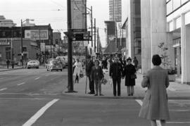
Intersection of Robson Street and Bute Street
Part of City of Vancouver fonds
Item part is a photograph of the intersection of Robson Street and Bute Street, looking northwest. Visible on the right is the Blue Horizon Hotel (1225 Robson Street), and on the left is the Sheraton Landmark hotel (1400 Robson Street), under construction.

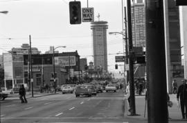
Intersection of Robson Street and Hornby Street
Part of City of Vancouver fonds
Item part is a street photograph from the corner of Hornby Street and Robson Street, looking northwest down Robson Street The Bar-B-Q World Famous Delicatessen (904 Robson Street), Modern Design & Mexican Gift Shop (906 Robson Street), and the signage for Rippy's Fine Foods are visible across the intersection. Other retail shops are visible along the street.
![J. Errington [car with sign promoting Pantages news reels]](/uploads/r/null/c/d/cdb57e563d153f42a664ada8235d45866fec4c1b47f86c05b916b925c788116d/89bd7ed8-701a-408c-a54d-ad8bdede25b0-A00623_142.jpg)
J. Errington [car with sign promoting Pantages news reels]
Part of Stuart Thomson fonds
![Jimmy Minns - Morris Chocolates Adv. Corp. [Sign inside a shop]](/uploads/r/null/1/8/d/18d98521da9602f16f78ed61187d8cfa6aff0d6514e78acea18d361e924b1fc9/c8b3238f-0659-4a52-b687-b6a6c6dd8677-CVA99-7190_142.jpg)
Jimmy Minns - Morris Chocolates Adv. Corp. [Sign inside a shop]
Part of Stuart Thomson fonds
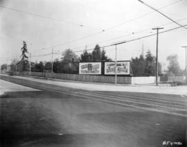
![Kingsway and Spencer [Street] north side city incoming](/uploads/r/null/0/b/0b22fa98bd15e0e85b9bc6ea22761cd6c9d5dd3dc096048aa45ec768ab85bdeb/29e3ccf0-9b92-4eef-975c-1c41c3d340f0-A20224_142.jpg)
Kingsway and Spencer [Street] north side city incoming
Part of Major Matthews collection
Photograph shows the Kingsway Bar-B-Q, a Richfield sign with a model car and a Ruddy-Duker Ltd. billboard advertising Monarch and Canadian Motors

Kingsway at Beatrice, post improvements
Item is a photograph of Kingsway at Beatrice, looking southeast, after the Kingsway improvements. Identified establishments visible in the photograph include Kingsway Woodworks, Geo. Collett Boot & Shoe Hospital, Steele and Co., and the Tyrell Block.

Kingsway at Beatrice, pre improvements
Item is a photograph of Kingsway at Beatrice, looking southeast, before the Kingsway improvements. Identified establishments visible in the photograph include Kingsway Woodworks, Steele and Co., and the Tyrell Block.
Kingsway at Commercial Drive, Natal Garage, post improvement
Item is a photograph of Kingsway at Commercial Drive looking west at the southwest corner of the intersection, after the Kingsway improvements. The photograph shows the Natal Garage and service station and a convince store. Coca-Cola and Orange Crush signs are on the side of the convenience store. The new sidewalks, utility poles with street lamps, and the newly expanded road are all visible.

Kingsway at Commercial Drive, Natal Garage, pre improvement
Item is a photograph of Kingsway at Commercial Drive looking west at the southwest corner of the intersection, before the Kingsway improvements. The photograph shows a small corner store, the Natal Garage and service station, and a building under construction. Coca-Cola and Orange Crush signs are on the side of the corner store, and a delivery truck for Fletcher's No. 1 Bacon is at the service station.

Kingsway at Commercial, post improvements
Item is a photograph of intersection of Kingsway and Commercial, looking south-east, after the Kingsway improvements. The identified establishments in the photograph are Kingsway Drug Co. Ltd, Fletcher's Meats Co. (Fletcher's No 1 Bacon on sign), and Scott's Home Bakery.

Kingsway at Commercial, pre improvements
Item is a photograph of intersection of Kingsway and Commercial, looking south-east, before the Kingsway improvements. The identified establishments in the photograph are Kingsway Drug Co. Ltd, Fletcher's Meats Co. (Fletcher's No 1 Bacon on sign), and Scott's Home Bakery.
Kingsway at Knight Street, southeast corner, post improvements
Item is a photograph of the intersection of Kingsway and Knight Street, looking at the southeast corner, after the Kingsway improvements. The photograph shows the widened section of Kingsway and the fully renovated fence and sidewalk sections across Knight Street. New billboards on Knight Street have advertisements for Forst's Radio (selling Philco radios) and City Coal Co.

Kingsway at Knight Street, southwest corner, post improvements
Item is a photograph of Kingsway at Knight Street, southwest corner, looking east, after the Kingsway improvements. The photograph shows the new sidewalk in front of Herbert Eldridge Drugs, the widened section of Kingsway, and the fully renovated fence and sidewalk sections across Knight Street. New billboards on Knight Street have advertisements for Forst's Radio (selling Philco radios) and City Coal Co.

Kingsway at Knight Street, southwest corner, pre improvements
Item is a photograph of Kingsway at Knight Street, southwest corner, looking east, before the Kingsway improvements. The photograph shows the sidewalk in front of Herbert Eldridge Drugs and the fence and sidewalk sections across Knight Street that would be soon renovated.
Kingsway at Victoria Drive, southeast, post improvements
Item is a photograph of the intersection of Kingsway and Victoria Drive, looking southeast, after the Kingsway improvements. Identified establishments on the southeast corner include the empty W. H. A. Van Alstine Drugs location (the old sign is visible behind the building) and Maple Leaf Barber Shop. There is a billboard for Shell Gasoline across the intersection further along Victoria. New utility poles, street light, and sidewalks care visible in the photograph, and the buildings have been renovated to accommodate the widened street.

Kingsway at Victoria Drive, southeast, pre improvements
Item is a photograph of the intersection of Kingsway and Victoria Drive, looking southeast, before the Kingsway improvements. Identified establishments on the southeast corner include W. H. A. Van Alstine Drugs, George Collett Boot and Shoe Hospital (before its move to the 1900 block of Kingsway), Maple Leaf Barber Shop, and Bell's Grocery. Across Kingsway in the right of the photograph is Star Grocery. There is a billboard for Turret Cigarettes across the intersection on Victoria.

Kingsway at Victoria Drive, southwest, post improvements
Item is a photograph of the intersection of Kingsway and Victoria Drive, looking southwest, after the Kingsway improvements. The corner of the empty W. H. A. Van Alstine Drugs location can be seen across Kingsway on the southeast corner of the intersection, on the southeast corner of the intersection an unidentified grocery store and W. S. Parcells real estate can be seen. Advertisements for Coca-Cola and Turret Cigarettes are visible on the grocery store building.

Kingsway at Victoria Drive, southwest, pre improvements
Item is a photograph of the intersection of Kingsway and Victoria Drive, looking southwest, before the Kingsway improvements. W. H. A. Van Alstine Drugs can be seen across Kingsway on the southeast corner of the intersection, on the southeast corner of the intersection Star Grocery, White Produce, and W. S. Parcells real estate can be seen. Advertisements for Coca-Cola, Toronto Dominion Trusts, and Seal Brand coffee are visible on the grocery store building.

Kingsway between Knight and Dumfries, looking northwest
Item is a photograph of Kingsway, between Knight Street and Dumfries Street, looking northwest. The awnings and partial storefronts of Stella Mae's Dressmaking and Ed's Fish & Chips are visible along the sidewalk leading up to Knight Street on the right. Diagonally across the Kingsway and Knight Street intersection several local businesses can be seen, including the Wayside Barber Shop, Sun Chong & Co., and Flemons.
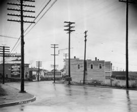
Kingsway between Tyne and Battison Streets, looking east
Item is a photograph of Kingsway, between Tyne Street and Battison Street, looking east. B.C. Telephone Co. equipment is visible at the construction site in the middle of the photograph. Advertisement billboards for The Seaton apartments and the Alcazar Hotel (Hotel Alcazar on the billboard) are visible. The building in the centre right of the photograph has "The Bungalow" written on the side.
![London Drug[s] Store [Georgia and Granville Streets]](/uploads/r/null/7/f/7fb4a6daabab0c6522a03eae8bc92484d496f003705e0b99558687e803f4dada/e802fc97-a0c6-4bc3-bce1-8c3e0abd3dcf-A21624_142.jpg)
London Drug[s] Store [Georgia and Granville Streets]
Part of Walter E. Frost fonds
Photograph shows the House of Furs, Henris, Kits Cameras Ltd. and Marvel Beauty Salon.
![[Looking north from the Granville Bridge towards Pacific Street]](/uploads/r/null/d/9/d95b334ffcc484115795998db84b7fd3447294013b3115de6cf84c43d5c4925f/1defde75-f718-4b7b-8639-08983fc0f15d-A20255_142.jpg)
[Looking north from the Granville Bridge towards Pacific Street]
Part of Major Matthews collection
Photograph shows a Ruddy-Duker Ltd. sign advertising Burn's Bakeasy on the roof of the Continental Hotel and billboards advertising "Gutta Percha" tires, Martin Senour Paints, Red Cedar Siding and Office Specialty

Macdonald's Prescriptions, Helen's Beauty Salon, Air Canada
Part of City of Vancouver fonds
Item part is a photograph of a group people waiting on the sidewalk outside a set of shops on the ground floor of the Medical-Dental Building (925 W. Georgia Street), taken from across the street. The establishments identified are Macdonald’s Prescriptions Ltd. (929 W. Georgia), Helen’s Beauty Salon Ltd. (925 W. Georgia) and an Air Canada location (905 W. Georgia).
![Main [Street] and 5th [Avenue] southeast lit [billboards]](/uploads/r/null/9/2/92137ae56e6c972513a0fa7e745f96f14fbbdf873815db9bfea2d1617b2e226a/6f6127d3-cdf1-4466-98cb-fcb03c213d36-A20235_142.jpg)
Main [Street] and 5th [Avenue] southeast lit [billboards]
Part of Major Matthews collection
Photograph shows Ruddy-Duker Company billboards one empty and one advertising gas appliances and the Ashnola Apartments with a G.L. Pop Furs sign painted on the building
![[Man sitting on chair in front of the Orpheum Theatre ticket booth]](/uploads/r/null/9/3/937e18e73bc96a42bdfe55dba115eec56dcbdb8457dc82d64cb55d80ea6724b9/0b93a331-aecd-4424-a6b3-6fcfaa08d971-A18769_142.jpg)
[Man sitting on chair in front of the Orpheum Theatre ticket booth]
Part of Stuart Thomson fonds
Photograph shows a sign 'I'm going to be the first to see "Mrs. Wiggs of the Cabbage Patch" starts Friday'
![[Man sitting on chair in front of the Orpheum Theatre ticket booth]](/uploads/r/null/2/3/231fb697bd052b14949373334d819cf851ca1779c3c2186ac34707e324fefab7/e299401e-87bc-4f67-8e9b-98ab9843914b-A18770_142.jpg)
[Man sitting on chair in front of the Orpheum Theatre ticket booth]
Part of Stuart Thomson fonds
Photograph shows a sign 'I'm going to be the first to see "Mrs. Wiggs of the Cabbage Patch" starts Friday'
![Mandarin Gardens [98 East Pender St.]](/uploads/r/null/3/f/3f28c60d913faec896b2749a9b58dd8dae3e5bf517619f39bb0faec61c6e0e1f/68eec1ca-f179-4895-b010-d662c35b80fd-A21602_142.jpg)
Mandarin Gardens [98 East Pender St.]
Part of Walter E. Frost fonds
Photograph shows the White House Chop Suey, Wo Fat Co. Bakery and O.K. Transfer.

Maple Tree Square before reconstruction
Part of City of Vancouver fonds
Photograph also shows the Eaton's Department Store and the signs for James Chambers and Inga Nielsen
![Maple Tree Square [construction]](/uploads/r/null/a/b/aba7db87e28e7c3b6ed72d38eb8401667a8d04a69d9fefb6ffb594fd6f1789b2/2b233493-07fd-4c9b-ac74-961216e1ef81-A59474_142.jpg)
Maple Tree Square [construction]
Part of City of Vancouver fonds
Photograph also shows the sign for Gassy's Joynt (6 Powell Street)
Maple Tree Square looking east from Water Street
Part of City of Vancouver fonds
Item part is a photograph of Maple Tree Square, looking east from the north sidewalk of Water Street. On the right the signage and awning of The Quest (Quest Team Three design projects Ltd., 1 Alexander Street) is visible. Across the square is Hotel Europe (43 Powell Street, at Alexander). On the left the identified establishments are Gassy's Joint (6 Powell Street) and The Boiler Room (8 Powell Street).
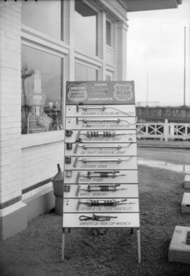
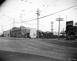
Marshall Wells Ltd. - Sign board at service station, Georgia & Beatty St.
Part of Stuart Thomson fonds

Marshall Wells Ltd. - Sign board at service station, Georgia & Beatty St.
Part of Stuart Thomson fonds
![McLennan, McFeely [and Prior Limited at 801 Columbia Street] Garage Door](/uploads/r/null/2/a/2a66db545a65d36779b75806258d715741ec40efb0cfc5b8af6f24e4094cf4e0/50a5aa1a-aec6-443d-99f1-42414d80df1e-A17527_142.jpg)
McLennan, McFeely [and Prior Limited at 801 Columbia Street] Garage Door
Part of Stuart Thomson fonds
Photograph shows a sign for "Rolltite" over-head door
![[Men reading Chinese notices and newspapers posted on bulletin boards on Pender Street]](/uploads/r/null/6/8/68d5027c0d2737ec8bcc70b0889851fea66fe2d92900e04f177be40503854ced/fd65d18e-c01d-4bf0-afbc-250159ac398f-A08840_142.jpg)
[Men reading Chinese notices and newspapers posted on bulletin boards on Pender Street]
Part of Major Matthews collection
J.S. Matthews' notes with print or negative in Archives.
![[Men reading Chinese notices and newspapers posted on bulletin boards on Pender Street]](/uploads/r/null/9/a/9acbf451a02c9ffef061d60a7d4cf7f2dd5521330f473fc6d84734760d8e3ea4/92369dc1-4e66-4fb2-9380-6074e103ec82-A08841_142.jpg)
[Men reading Chinese notices and newspapers posted on bulletin boards on Pender Street]
Part of Major Matthews collection
J.S. Matthews' notes with print or negative in Archives.