- AM1594-MAP 342b-: MAP 342b.37
- Item
- Dec. 1912
Part of City of Vancouver Archives technical and cartographic drawing collection
Item is a map depicting an area bounded by the following streets: Park Street (now Boundary Road) (west side only) to Wellington Avenue/Vanness Avenue (south side only) to Fairmont Street/Rupert Street (east side only) to Forty-sixth Avenue East (north side only).
![Plate 102: Sunset [Windsor Street - Forty-seventh Avenue - Ontario Street - Fifty-seventh Avenue]](/uploads/r/null/2/7/7/2774c2f1fba864e5a24bcce75925abb510bd59d91b4f731f0981d73a411a7d48/02a6a42f-7b26-4852-b5fc-247ec69ad7bc-MAP342b_142.jpg)

![Plate 105: Killarney [Park Street - Forty-sixth Avenue - Rupert Street - Fifty-sixth Avenue]](/uploads/r/null/3/f/2/3f2506180ab01b1bb3e8b93fc8556eaf993c3fed6a652c75cb5f9c1d7a3e58b5/f47931f6-b379-41cb-a6a7-df51e419ab26-MAP342b_142.jpg)
![Plate 106: Sunset [Windsor Street - Fifty-seventh Avenue - Ontario Street - River Avenue]](/uploads/r/null/b/7/c/b7cc0f09fe00083730411f233c5e11762eb97c1fc073492479217426ee16a808/f965ed04-f310-4ef4-91c8-74c88c6a0397-MAP342b_142.jpg)


![Plate 109: Killarney [Park Street - Fifty-sixth Avenue - Rupert Street - Sixty-seventh Avenue]](/uploads/r/null/4/a/c/4acecb61c004796981588a8886b2eb1fe6ed6b02344dd60ba3bc8ef0cc7e3ea4/b017a2f8-ed59-4eac-b2e3-104fc002e01c-MAP342b_142.jpg)
![Plate 110: Sunset [Windsor Street - River Avenue - Ontario Street - Fraser River]](/uploads/r/null/0/5/1/0517315aa9f84af3bc4f564f523aaf9e067d9b2cd00a4aa1ae4c0fdeafa3e930/1c54d499-8d65-47ea-8942-f6a78a82a9ae-MAP342b_142.jpg)


![Plate 113: Killarney [Park Street - Sixty-seventh Avenue - Rupert Street - Fraser River]](/uploads/r/null/d/c/6/dc6f37ebae27a37b14cb5b18025ffac1646066b421e01663f748b244aca25200/8c3aa04a-1f90-4780-a260-048c78490ec5-MAP342b_142.jpg)


![[Lord Selkirk School, showing old and new buildings]](/uploads/r/null/6/a/6a6fde7e4903376286d5c956ddb89099828704fbf1f59cd87ec8c27e63970b9f/5c6536fd-ae86-4f62-9eac-378c5d5a457a-A07858_142.jpg)
![[First school in South Vancouver, near River Road (Marine Drive) and North Arm Road (Fraser Street)]](/uploads/r/null/6/a/6a404d88093bf8a1dbf5a12f34ff8e1ec6b04a02debe4e9015a7410eaf174fb3/59c47d3f-5c27-4275-928a-5391f058e5bd-A07857_142.jpg)
![[First school in South Vancouver, near River Road (Marine Drive) and North Arm Road (Fraser Street)]](/uploads/r/null/2/8/28f3e1b055c6d8ceccc9b155d2452d4881ceb049bae05977f0e56236e3f3b5de/5ea5e477-b53a-4038-8a8e-ae75386d4d52-A07856_142.jpg)
![[People entering streetcar on Main Street at 25th Avenue]](/uploads/r/null/7/3/73e5b03273a4342e33703d759e95195f161d4b05b3c73be4d76ba5118bebd463/d73b91e1-7630-459f-ae97-2cd75375f37e-A04880_142.jpg)
![[View of the 3500 block Commercial Street looking north from 20th Avenue]](/uploads/r/null/f/1/f1b0bce3d006392eacb862cfcf2dcf83c3f8413c7c9f87b3a1112ba5d9f95899/45c4154f-fb02-4471-bfe7-f45508705373-A07869_142.jpg)
![[View of Main Street, looking north from 26th Avenue]](/uploads/r/null/4/c/4cbdef125de15aa81c70e8709b292d5e4f274528f32b6cb2a2105258b3cafcb5/e6b7109b-66b4-4835-afc6-7609526820c9-A07868_142.jpg)
![[Carleton School]](/uploads/r/null/6/b/6ba9a40a9e7a0498b0fae3cc2d0a7e8310875d5e723008d1b7109862cc54f2ba/fdd10c5b-f9f9-4077-ae26-9b526532a8ab-A07861_142.jpg)
![[Carleton School, showing old and new school buildings]](/uploads/r/null/1/5/153eafd04f55340499a80c8ab1e5e9f567e164eb0353cac39f56dd06b4d1560d/d489bfce-80c4-4fc0-8cff-efc2470ed666-A07860_142.jpg)
![[Lord Selkirk School]](/uploads/r/null/3/3/336779f87c5e4b2c20e6321486e1fdbe8ba8fe3fa6e12da756a9af5a87d92f58/d8d6f1a1-e2e8-4b3c-a830-b81ac04d2756-A07859_142.jpg)

![[H.T. Bell residence estate, corner of Slocan and 29th Avenue]](/uploads/r/null/4/1/41e5fa64745fe203d8c5fdbf1c7a8f801429102c17bda8c7276e849fb4e4c97f/0f8301a4-1554-40d8-a40d-7c4eb1cabbeb-A63414_142.jpg)

![[House on 29th Avenue near Fraser Street]](/uploads/r/null/c/1/c1f72a09d8ea5703721e29e9953e5ace4143d7e19a2a034242fdf32b3f523cd4/205c8ba7-1d4e-460f-a273-a31444e39c43-A49956_142.jpg)
![[Jack Davidson eating corn]](/uploads/r/null/6/9/69a4f80f71f8058960f023751591eb6f4a0122544d8330544ecbc473785929e2/d106bef5-df9b-476b-8528-2174d94fee1f-A50380_142.jpg)
![[Ruth Morton Memorial Church under construction on East 27th Avenue and Prince Albert Street]](/uploads/r/null/4/7/47bb9e9c1450543d0ce71ccac6cffd8431e7c732b74853b65bb04d2d3bd8757d/23958175-9c5f-4f7e-a0f4-ed03717b0b5e-A50548_142.jpg)
![Ruth Morton [temporary Memorial Church on East 27th Avenue and Prince Albert Street]](/uploads/r/null/6/d/6d367f7a37f3eff590a58145183bd051bb7a744688d0f5977dcadcb9305659d6/1cb78a49-02ab-4135-ad5d-47bd011e5a5f-A50578_142.jpg)

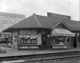
![Collingwood Station [on the B.C.E.R.] Central Park line](/uploads/r/null/9/1/91274133061ed1f0856554d68884180be235d48fe6ad8d73a6437a3d8e6a275c/5aea6d9a-2760-4ff4-924a-cf56eb88582d-A02217_142.jpg)