
City of Vancouver Waterworks Department. Profile of Capilano and Seymour Creek water mains
- AM54-S4-: VLGN 3
- Item
- [1908?]
Part of Major Matthews collection
Photograph negative is a copy of an annotated plan showing the path of the water mains.
703 results with digital objects Show results with digital objects
City of Vancouver Waterworks Department. Profile of Capilano and Seymour Creek water mains
Part of Major Matthews collection
Photograph negative is a copy of an annotated plan showing the path of the water mains.
![City Waterworks [Capilano Creek Dam]](/uploads/r/null/e/9/e9761177a88bcafc9c640a7180504b8df47f6cd49644720806efc6f3178d8e2b/2f2c5021-6221-40c8-bd1b-3c8ad899e761-A25796_142.jpg)
City Waterworks [Capilano Creek Dam]
Part of Major Matthews collection

City waterworks dam, Vancouver, B.C.
Part of Major Matthews collection

Civic Official Visit - Capilano Dam
Part of Major Matthews collection
Photograph shows Alderman McQueen, Alderman Robert Grant, Alderman Bethune, W.H. Armstrong, Alderman W.H. Wood, Steve Maddison's uncle, Colonel Tracy, Sam Robb, Pete Larson, W.F. Findlay and others
![[Clearing the road after the Seymour Creek washout]](/uploads/r/null/f/c/fc6cfe672265e867d583e925ffa6c0fd3a92c7305bcba121a6f71a099afd83a8/56561df4-6b84-4fc0-b5c1-6523edbfeb84-A33580_142.jpg)
[Clearing the road after the Seymour Creek washout]
Part of Major Matthews collection
![[Clearing the road after the Seymour Creek washout]](/uploads/r/null/9/9/99242e16650f1431f325e9bb60c86ba094a887a37b72eeded67645bde3379e12/ce8d67eb-7f17-43dd-9625-f5b95c1c1b2d-A33576_142.jpg)
[Clearing the road after the Seymour Creek washout]
Part of Major Matthews collection
Photograph shows F.L. Fellowes
![[Clearing the road after the Seymour Creek washout]](/uploads/r/null/1/e/1ebe2d6f26e96a26ae0360f58ff42655dc2845782a4d16f4c7b5cb8d33146801/4c35ed37-348f-40ff-b97f-a63d9d9360dd-A33569_142.jpg)
[Clearing the road after the Seymour Creek washout]
Part of Major Matthews collection
![[Clearing the road after the Seymour Creek washout]](/uploads/r/null/3/5/358ec572746441d60d555a7b7babb4ca18786ae34ac812377045d3a3d70e3016/6ba322a6-c3e9-4474-a5b9-944593cdf228-A33579_142.jpg)
[Clearing the road after the Seymour Creek washout]
Part of Major Matthews collection
Photograph shows F.L. Fellowes and others

Part of Major Matthews collection
Part of Major Matthews collection
![[Construction of reservoir at Burwell Lake]](/uploads/r/null/0/9/09c494c0b883a3802afc29a5e0bfc8fad1ac3d712e98b1752cd982e0e7fbba5a/e7e4cb28-28df-4157-8e36-7b99bd5469da-A09314_142.jpg)
[Construction of reservoir at Burwell Lake]
Part of Major Matthews collection
![[Construction of reservoir at Burwell Lake]](/uploads/r/null/4/1/41b1e914a992698a666e1d324c08055e61e7e87450fe7023e1739d2104827b24/83bb7367-b7ef-4bbb-85d2-82a6f3fd608e-A09315_142.jpg)
[Construction of reservoir at Burwell Lake]
Part of Major Matthews collection
![[Construction of reservoir at Burwell Lake]](/uploads/r/null/7/7/7786039fc4e1c663927bd33feba77389488d28e353a4030d15f3eea0e1a4b468/f296699c-b70d-4760-8bb2-ca669d9a76fc-A09319_142.jpg)
[Construction of reservoir at Burwell Lake]
Part of Major Matthews collection
![[Construction of reservoir at Burwell Lake]](/uploads/r/null/5/d/5d3eb3f1bd505c6d220057e12b921c693540398850bda204a6a8d104d3246071/6901d2e1-572e-44dd-bc4d-126bb3859d8a-A09321_142.jpg)
[Construction of reservoir at Burwell Lake]
Part of Major Matthews collection
![[Construction of reservoir at Burwell Lake]](/uploads/r/null/e/b/eb9eeb61a07c40e659f16d7a93d242fb45f3052c84a2030adc4a697889e0df29/5337f4ba-277a-45b9-9fe8-01550babb996-A09316_142.jpg)
[Construction of reservoir at Burwell Lake]
Part of Major Matthews collection
![[Construction of reservoir at Burwell Lake]](/uploads/r/null/f/4/f4c1ee406ab1ccce7c74848cb0cba56f53b598a623a439a8ca4d44ad4b2797ad/33ff1f59-9af4-4f19-849e-84bd166c0625-A09322_142.jpg)
[Construction of reservoir at Burwell Lake]
Part of Major Matthews collection
![[Construction of reservoir at Burwell Lake]](/uploads/r/null/1/e/1eedbf6660c92fee74fe3c85201f418d85466ff298cf56c76c8bd153bb5339ee/d5226763-8e90-434b-a7ef-f201a089ddc7-A09317_142.jpg)
[Construction of reservoir at Burwell Lake]
Part of Major Matthews collection
![[Construction of reservoir at Burwell Lake]](/uploads/r/null/8/7/87e8d66e8c43805bf9c3645e4aea7a1afc029a4f5dcea09bcda5879d6b168646/41f5686c-ee46-4912-9374-a4f7124797b1-A09318_142.jpg)
[Construction of reservoir at Burwell Lake]
Part of Major Matthews collection
![[Construction of reservoir at Burwell Lake]](/uploads/r/null/6/d/6d1ee3e072911bde1295b5233e9dd298b6d11cba5fa6de08cd9fab25d080b4d5/b6f3049e-888c-430b-b9e4-8a3a1bd2220c-A09320_142.jpg)
[Construction of reservoir at Burwell Lake]
Part of Major Matthews collection
![[Cooking meat at a W.A. McIntosh's butchershop employees picnic]](/uploads/r/null/3/f/3fd0701bb0bc9ec863b5e3340e7a555a0728bc472aa5cb7743940337fd863be0/64e987cc-ad48-4265-b6ca-181abfc1e1ec-A33847_142.jpg)
[Cooking meat at a W.A. McIntosh's butchershop employees picnic]
Part of Major Matthews collection
![Cornice [on] Mount Crown](/uploads/r/null/d/a/da53a041b1170fc20a9899c7c7769834da110e3443cda69d522581b7007fc63f/0b6d6b6c-b02b-48c7-9442-83efa579213c-A22614_142.jpg)
Part of Major Matthews collection

Part of Major Matthews collection

Councillors District of North Vancouver being sworn in by Judge R.A. Sargent
Part of Major Matthews collection
Photograph shows Councillor G.W. Sargent, Councillor A.D. Poole, Councillor F.M. Reid, Councillor C.E. Scanlan, Councillor William Griffin and Councillor D.G. Currie

Part of Major Matthews collection
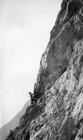
Photograph shows a cornice

Creek north side of Crown Mountain
Part of Major Matthews collection

Part of Major Matthews collection

Part of Major Matthews collection
Part of Major Matthews collection
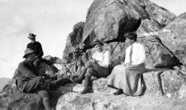
Photograph shows a group of hikers resting
Part of Major Matthews collection
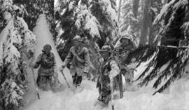
Photograph shows four people covered with and knee-deep in snow

Part of Major Matthews collection

Part of Major Matthews collection

Crown Mountain from the fork of Lynn Creek
Part of Major Matthews collection

Crown Mountain from White Mountain
Part of Major Matthews collection

Crown Mountain from White Mountain
Part of Major Matthews collection

Crown Ridge, Grouse Mountain Park
Part of Major Matthews collection

Part of Major Matthews collection

Part of Major Matthews collection
Photograph shows snow covered trees and Point Grey in the background

Part of Major Matthews collection
![[Damage to water pipes after the Seymour Creek washout]](/uploads/r/null/4/3/43b1c7dccd6a8f384bd9b2e8e036e4b27bdf029bf08c50e792fc2fe217d6136e/6b2267a2-fbca-4c3c-b913-aaa1d247cb7f-A33568_142.jpg)
[Damage to water pipes after the Seymour Creek washout]
Part of Major Matthews collection
Photograph shows F.L. Fellowes and others
![[D.C. McGregor and J.J. Godfrey at The Mission]](/uploads/r/null/c/1/c196a01e9f0fb37734d5ddba521bf8b601e6889ad6b7b210e1a8665270bb015c/b81172df-e940-4da6-8286-58f9e21b180f-A26401_142.jpg)
[D.C. McGregor and J.J. Godfrey at The Mission]
Part of Major Matthews collection
![[Descending Grouse Mountain on the Capilano side]](/uploads/r/null/c/a/caf4b7b3488f437c32926bd9c54a8d474061930b49f09480084986f9d430beb3/623bee6a-689a-4248-8433-93097fc09a87-A32796_142.jpg)
[Descending Grouse Mountain on the Capilano side]
Part of Major Matthews collection

Part of Major Matthews collection

Part of Major Matthews collection
The map is a draft of MAP 56.01, "Indian villages and landmarks, Burrard Inlet and English Bay, before the whiteman came." It shows the geographic area bounded by the north shore of Burrard Inlet, the Freaser River, Point Atkinson, and the Burrard Inlet Second Narrows. Shown on the map are locations of First Nations and European settlements, streams, coastal features, and inland vegitation. Physical features are labeled using both First Nations and European place names.

Draft map of Indian villages and landmarks, Burrard Inlet and English Bay, before the whiteman came
Part of Major Matthews collection
The map is a draft of map 56.01, "Indian villages and landmarks, Burrard Inlet and English Bay, before the whiteman came." It shows the geographic area bounded by the north shore of Burrard Inlet, the Fraser River, Point Atkinson, and the Burrard Inlet Second Narrows. Shown on the map are coastal sites labeled with First Nations place names.

Part of Major Matthews collection
Photograph shows two hikers taking a rest

Part of Major Matthews collection
Photograph shows hikers having a rest

Part of Major Matthews collection

Part of Major Matthews collection

Part of Major Matthews collection
![Edward VII Memorial Service [at the Horticulture Hall]](/uploads/r/null/f/e/fefc5cb8fea3b0329418147add7cb5c6efa0c90750a0ad9a88364be71e0c8cd7/1e0f0e8e-2ec3-4daa-a1c3-9d9ef1357d60-A32779_142.jpg)
Edward VII Memorial Service [at the Horticulture Hall]
Part of Major Matthews collection