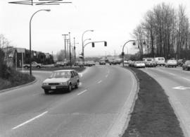
![RLS [Cars on side street, 2 of 2]](/uploads/r/null/3/1/d/31d266c99981ea03ba885de387fa5c8db128ba15ce3983a781f19ce296d547be/4fec0eb5-524e-46d6-98b8-12ec557b55dd-2019-103.0064_142.jpg)
RLS [Cars on side street, 2 of 2]
- COV-S505-1-: 2019-103.0064
- Item
- [198-?]
Part of City of Vancouver fonds
3217 results with digital objects Show results with digital objects
RLS [Cars on side street, 2 of 2]
Part of City of Vancouver fonds
![Oak [Street] and 12th [Avenue intersection, 1 of 4]](/uploads/r/null/7/5/6/756fcab838ddb70f9c8cc25680cfb7f367acacc5fe3dd748e4f4480324aa11a0/469601e7-8ad9-4d72-a971-864d91bcba8b-2019-103.0266_142.jpg)
Oak [Street] and 12th [Avenue intersection, 1 of 4]
Part of City of Vancouver fonds
Looking west on East 15th Ave. toward Knight St.
Photograph shows depression in 15th Avenue where China Creek once flowed. To the right is Clark Park. Additional descriptive information on back of print.
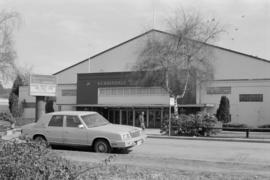
Photograph shows automobile parked in front of Kerrisdale Arena, 5670 East Boulevard

Safeway grocery store at Kingsway and Knight St.
Photograph shows store and parking lot. Part of a Domo gas station visible in foreground

Safeway grocery store at Kingsway and Knight St.
Photograph shows store and parking lot.

Intersection at Cambie St. and Broadway
Photograph taken facing west down Broadway. Visible in photograph are signs for Fogg n' Sudds restaurant, Orchid Garden restaurant, and London Drugs

Safeway grocery store at Kingsway and Knight St.
Photograph shows store and parking lot.
![Boundary [Road] and 49th [Avenue looking] west](/uploads/r/null/9/c/9cc0a485786529b7ea995102ef13d2652a30d9bb89c6b4daf2889a322b7380b4/b297ebec-79c3-4ff2-bc75-6b0b900e0bcb-A42900_142.jpg)
Boundary [Road] and 49th [Avenue looking] west
Part of City of Vancouver fonds
![Cassiar [Street] and [Highway] 401 [4 of 7]](/uploads/r/null/3/8/d/38d7115bff9526ca7c5034b8abeef664f039dcd1d443cf38520ddbde19c2a61e/6efb9cd8-9b85-4ad5-9c1c-0016ed26f58f-2019-103.0540_142.jpg)
Cassiar [Street] and [Highway] 401 [4 of 7]
Part of City of Vancouver fonds
![Cassiar [Street] and [Highway] 401 [traffic controller]](/uploads/r/null/b/d/0/bd0e2388f24d27e28dec07806e6440b83687233a38ac5ad89c0cbfd6303d5053/9bd4321e-024d-4b29-86b1-321ed762a7fe-2019-103.0545_142.jpg)
Cassiar [Street] and [Highway] 401 [traffic controller]
Part of City of Vancouver fonds
![[Alma Street and 16th Avenue intersection]](/uploads/r/null/3/7/b/37b84d66c7a0cca3b6ab18d5355e604f15172fe2714d6d640ed738e1e1b89be7/2849527f-4b4e-487f-baef-6e0b2a0240eb-2019-103.0325_142.jpg)
[Alma Street and 16th Avenue intersection]
Part of City of Vancouver fonds
![W Blvd and 49th [Avenue intersection, 4 of 4]](/uploads/r/null/5/8/d/58d28a98e71676c0b5a01be0b9695d10ce621d797c52fae2b7ca257bdb1991d7/b1ebf0d8-56e7-4d9e-afc8-ba6c1b14783c-2019-103.0424_142.jpg)
W Blvd and 49th [Avenue intersection, 4 of 4]
Part of City of Vancouver fonds
![Commercial [Drive] and 12th [Avenue intersection, 1 of 4]](/uploads/r/null/8/2/8/8284645662caab88b4e7d5bcd58db630a9abfbbe3274e85cecb64a6d9640201c/ec0684e7-162d-4a7f-80ff-2864ca316bce-2019-103.0013_142.jpg)
Commercial [Drive] and 12th [Avenue intersection, 1 of 4]
Part of City of Vancouver fonds
![Commercial [Drive] and [Broadway intersection, 2 of 4]](/uploads/r/null/2/8/e/28e782352834b53c9a02d92acefa571f1901526555ab41711d57b361a3d9d9bc/c3a46264-756f-4095-8b36-1941c6246536-2019-103.0019_142.jpg)
Commercial [Drive] and [Broadway intersection, 2 of 4]
Part of City of Vancouver fonds
![Victoria [Drive] and [South East] Marine [Drive intersection, 1 of 2]](/uploads/r/null/8/0/5/8059e4bb60c014c42369af0d2c2fec8b65f4bed3cecc708b0870d754c148f0a8/d25ed32d-bfd1-42e4-a4f0-3289977ac7bb-2019-103.0058_142.jpg)
Victoria [Drive] and [South East] Marine [Drive intersection, 1 of 2]
Part of City of Vancouver fonds
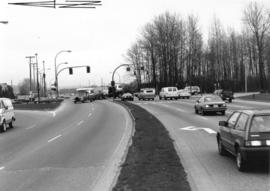
![RLS [Intersection]](/uploads/r/null/9/a/5/9a50e1cf72cf7dcd74c15366f787afd9cacdc69be54a99ddbf30e5f032c21f2e/799b6320-49e5-4eb4-83b6-ed260800df48-2019-103.0065_142.jpg)
Part of City of Vancouver fonds

Part of BC Gay and Lesbian Archives
![Boundary [Road] and 49th [Avenue looking] east](/uploads/r/null/5/1/51fd0d3aba484586c608e65201084d88cd7aa72720a8c48eacd723f460fa7ef0/8e0dd36a-93a8-4e84-b643-33bab58b89a2-A42901_142.jpg)
Boundary [Road] and 49th [Avenue looking] east
Part of City of Vancouver fonds
![Cassiar [Street] and [Highway] 401 [5 of 7]](/uploads/r/null/d/5/5/d55876baf2e7963f7c2d7bedaeae7d4f60e336bf135546b3da810e838ad4920b/1c7fcca8-470f-42ee-92a9-c65a29c13f38-2019-103.0541_142.jpg)
Cassiar [Street] and [Highway] 401 [5 of 7]
Part of City of Vancouver fonds
![Burrard [Street] and 16[th Avenue intersection, 1 of 4]](/uploads/r/null/4/e/0/4e0297b1e459a2e748746edd556eb897c9d55f9b530a292f74f8b453d19ae78a/f82fb1e3-7489-4c4c-b8ef-f45e25cb65e3-2019-103.0619_142.jpg)
Burrard [Street] and 16[th Avenue intersection, 1 of 4]
Part of City of Vancouver fonds
![Alder [Street] and Broadway [intersection, 2 of 4]](/uploads/r/null/9/1/c/91ccae5f43652163553e7e1550368296c9f011a37ab2ed78311769b507e8e41d/2bbc7f48-0e7e-49f0-a64b-ac63aa8cc96c-2019-103.0674_142.jpg)
Alder [Street] and Broadway [intersection, 2 of 4]
Part of City of Vancouver fonds
![Roll "A" [Parked cars on street]](/uploads/r/null/1/8/a/18a4c53216377962506c12c71f0ee9702f13cc1f46fc9f5b6fa0d62ba127d532/b1136924-de0d-4160-9606-a081bbe84b33-2019-103.0004_142.jpg)
Roll "A" [Parked cars on street]
Part of City of Vancouver fonds
![Commercial [Drive] and 12th [Avenue intersection, 3 of 4]](/uploads/r/null/f/a/8/fa862b4202310a9ced5bba82bf710b15054357d17d5987bcf242d1bb8159e675/570edfa6-adc7-46f7-9ade-78f5201ee35c-2019-103.0015_142.jpg)
Commercial [Drive] and 12th [Avenue intersection, 3 of 4]
Part of City of Vancouver fonds
![Commercial [Drive] and 12[th Avenue intersection, 4 of 4]](/uploads/r/null/5/5/f/55f34d2742f208a16427d4b5f32ba573dd54d6034196eb1b7d1bdcf2e4282eaf/8ce2b31c-e133-4159-afbd-149a55c6823b-2019-103.0016_142.jpg)
Commercial [Drive] and 12[th Avenue intersection, 4 of 4]
Part of City of Vancouver fonds
![Commercial [Drive] and [Broadway intersection, 3 of 4]](/uploads/r/null/7/f/5/7f5942068e43ab7e090da7596871cd5e4c2684e7aadff938e962271ae2576f88/899b7911-786c-43d9-9948-0314d5ca1ebb-2019-103.0020_142.jpg)
Commercial [Drive] and [Broadway intersection, 3 of 4]
Part of City of Vancouver fonds
![Victoria [Drive] and Kingsway [intersection, 1 of 3]](/uploads/r/null/d/0/a/d0ac865472fd1f6c571a13b624f7be52aafaac13ef4cacf7f9e4db270a7d8abb/24557994-c6e4-4114-aa4c-2a42ee461fad-2019-103.0023_142.jpg)
Victoria [Drive] and Kingsway [intersection, 1 of 3]
Part of City of Vancouver fonds
Looking west on East 15th Ave. toward Knight St.
Photograph shows depression in 15th Avenue where China Creek once flowed. To the right is Clark Park.

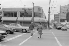
Intersection at Broadway and Cambie St.
Photograph taken from south-west corner, facing south. Trolley bus visible in foreground, Royal Bank building visible in background
Intersection at Cambie St. and Broadway
Photograph taken facing west down Broadway. Visible in photograph are signs for Fogg n' Sudds restaurant and Orchid Garden restaurant

Part of BC Gay and Lesbian Archives
![Commercial [Drive] and 12th [Avenue intersection, 2 of 4]](/uploads/r/null/d/a/c/dace718e8586f77ee1a7ad482256ac06ef5017b232bbfd3308a7a8e895e6b20e/7481440e-3eec-4c31-a8bf-cb23c38a3039-2019-103.0014_142.jpg)
Commercial [Drive] and 12th [Avenue intersection, 2 of 4]
Part of City of Vancouver fonds
![Commercial [Drive] and [Broadway intersection, 4 of 4]](/uploads/r/null/7/b/4/7b4fd16c97f371ccd8023837e3a8e29e86efe1ed23178b637616faf07205b304/4ebf0285-3b41-4406-a106-172b9a3b7f42-2019-103.0021_142.jpg)
Commercial [Drive] and [Broadway intersection, 4 of 4]
Part of City of Vancouver fonds
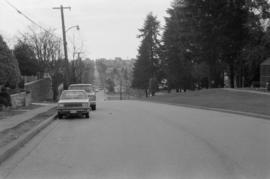
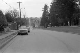
![RLS [Cars on side street, 1 of 2]](/uploads/r/null/d/1/b/d1bf7de3bef544b3810b340164177c6c5f78ad3070b552f59e7f92348047a641/b39c90cc-f4d8-45f5-aa0c-95688166c02a-2019-103.0063_142.jpg)
RLS [Cars on side street, 1 of 2]
Part of City of Vancouver fonds
![RLS [Intersection]](/uploads/r/null/6/d/f/6dfe88a0d740cf69f057aa49afaac2c09edd88135ab5d099050e2a9fd0d6d68a/f6cf2dc2-f41c-4d10-89a8-5511543dfd33-2019-103.0066_142.jpg)
Part of City of Vancouver fonds
![Oak [Street] and 12th [Avenue intersection, 2 of 4]](/uploads/r/null/1/e/1/1e17dd9263a2e792e37fc3f576100c7cbde4936974913dc70cd7dd173e2d8adc/c92cf20e-674d-4c24-8963-fadb5c2db389-2019-103.0267_142.jpg)
Oak [Street] and 12th [Avenue intersection, 2 of 4]
Part of City of Vancouver fonds
![Oak [Street] and 12th [Avenue intersection, 3 of 4]](/uploads/r/null/8/4/e/84e1f5c7bbab2384848edf9993fdcf6f1b0e035348f0ac8713d5ee5533f748da/4f452c63-8345-4b7e-8220-0841e6b96c77-2019-103.0268_142.jpg)
Oak [Street] and 12th [Avenue intersection, 3 of 4]
Part of City of Vancouver fonds
![[Person holding "M" sign out of a City of Vancouver car]](/uploads/r/null/3/7/0/37080d28b27dc52794f3d44edab5f2e94b4bee89e71a82b4464464cfc985f114/6d259242-b69c-4dfa-bd83-3f095f97eaf2-2019-103.0314_142.jpg)
[Person holding "M" sign out of a City of Vancouver car]
Part of City of Vancouver fonds
![W Blvd and 37[th Avenue intersection, 7 of 7]](/uploads/r/null/3/9/b/39ba281388109c5d462b4058a66d864463ca5b38d96852c634928df2e67c1a97/635087c3-aa13-43c2-af07-cbda9f2387d5-2019-103.0448_142.jpg)
W Blvd and 37[th Avenue intersection, 7 of 7]
Part of City of Vancouver fonds

View looking north on Boundary Road from Marine Way
Part of City of Vancouver fonds
View looking east on Marine Way at Boundary Road
Part of City of Vancouver fonds
View looking east on Marine Way at Boundary Road
Part of City of Vancouver fonds
Item contains a commercial exhibitor floor plan, tech sheets, and collectors' highlights for the motorsport show, March 4-6, 1988, and the PNE.

Southbound Boundary Road at Marine Way
Part of City of Vancouver fonds
![Boundary [Road] and Vanness [Avenue looking] south](/uploads/r/null/5/7/57b3b5194d06cce1c517a99492bba2c591a0ab830207fdf94bd866dad6ead7d7/e2ed7a74-f813-400a-b135-71a512d67d30-A42881_142.jpg)
Boundary [Road] and Vanness [Avenue looking] south
Part of City of Vancouver fonds
![VLC [Vancouver Lesbian Connection] Lesbian Info Mobile : ILW [International Lesbian Week] 1987](/uploads/r/null/b/d/3/bd3b025990c397473ebedf9f620476f20b079a1798a81eaf3f67c2498b316868/fb97a16d-2600-494e-a92b-040763b031ea-2018-020_142.jpg)
VLC [Vancouver Lesbian Connection] Lesbian Info Mobile : ILW [International Lesbian Week] 1987
Part of BC Gay and Lesbian Archives
![VLC [Vancouver Lesbian Connection] Lesbian Info Mobile : ILW [International Lesbian Week] 1987](/uploads/r/null/8/0/9/8099aaf00537aab0f0048244362092a7f9e2f6af70e0beb5773ee710ca8b6f11/f2805b9c-6dfb-4cc4-9eed-8666a2d40a91-2018-020_142.jpg)
VLC [Vancouver Lesbian Connection] Lesbian Info Mobile : ILW [International Lesbian Week] 1987
Part of BC Gay and Lesbian Archives

Make Vancouver Sparkle grand prize Ford car in trailer

Man photographing helicopter from parking lot

Helicopter delivering car to Vanier Park parking lot