![[Seymour School]](/uploads/r/null/2/6/b/26bc1979c984cfe98df133dc43a2c24fbb1b34108ee1020102f47eb2ce3d1e0d/6c62da31-1447-4b57-8e33-f937769c973e-CVA1095-15262_142.jpg)
- COV-S644-: CVA 1095-15262
- Item
- [1976 or 1977]
Part of City of Vancouver fonds
Part of City of Vancouver fonds
![[Seymour School]](/uploads/r/null/0/6/0/060fde8dc826930099081835f494216c1262ed9c0c5cb4cf6a3f0b052ea42755/c1d35124-3244-4255-a1bb-9b4520821fa0-CVA1095-15276_142.jpg)
Part of City of Vancouver fonds
Russian Church at Georgia and Campbell
Part of City of Vancouver fonds

Part of City of Vancouver fonds

Part of City of Vancouver fonds
Item is a map created to depict utilities in the proposed project 2 area 6. The map shows fire alarms, sewer lines, water lines, gas lines, underground telephone lines, underground power lines, underground vaults, and curbs. Also noted are existing buildings which may be cleared in future projects, existing buildings in immediate vicinity of area a-6 which may remain, existing subdivisions to be cancelled, easement boundaries, approximate elevations at street intersections, approximate locations at contours and areas for disposal ("private development" and "public housing").
![[Rear view of row of Strathcona houses]](/uploads/r/null/5/5/6/55600ec0ebfd1cec05a8044d1f43e8d664d0b4142b04f7c987e2cd9d5bc23ae2/3e12cd02-623f-439a-8d7a-aa53ee030bd3-CVA1095-01769_142.jpg)
[Rear view of row of Strathcona houses]
Part of City of Vancouver fonds
![[Rear view of 658 Union Street]](/uploads/r/null/1/2/0/12014e1b2c31d799a8941b22fa2420ae71bafc75251ffc12757a8b087cc9f7dd/160ea762-71a4-487e-a96f-b1d5935e1823-CVA1095-02373_142.jpg)
[Rear view of 658 Union Street]
Part of City of Vancouver fonds
![[Rear of Seymour School, 2 of 2]](/uploads/r/null/9/6/4/9641510670b03c4e6416977e06e7cce63981a9084748f78e3d70797f1731fa7f/5eb18a67-5e56-4805-ab1d-c0fd997906ac-CVA1095-15378_142.jpg)
[Rear of Seymour School, 2 of 2]
Part of City of Vancouver fonds
![[Rear of Seymour School, 2 of 2]](/uploads/r/null/2/a/7/2a7a73a7a937de6fab101c3e3c11c453a0b71ada8876547675013b128e2f7953/7730bcbc-8bb7-4cdb-969c-c1c498d3e7c6-CVA1095-15390_142.jpg)
[Rear of Seymour School, 2 of 2]
Part of City of Vancouver fonds
![[Rear of Seymour School, 1 of 2]](/uploads/r/null/4/9/9/4996b6c30f724a3dabd1995bb6ed468dc4fdc115d4d1907df2b792c4973f5659/e1392216-ae1f-4635-bdad-06635dd14174-CVA1095-15377_142.jpg)
[Rear of Seymour School, 1 of 2]
Part of City of Vancouver fonds
![[Rear of Seymour School, 1 of 2]](/uploads/r/null/9/6/0/9606fc2cb7c344338e2280ad0fb06e733a9834f57541c6393ddf4e3c24c3af97/4c5ad851-80d3-431f-b72d-5473226b2770-CVA1095-15389_142.jpg)
[Rear of Seymour School, 1 of 2]
Part of City of Vancouver fonds
![[Rear courtyard of 450 East Cordova Street]](/uploads/r/null/5/3/a/53a998578a4ead20b8b21c9af98552370c55cffe34733f0f25e5d2a4f5794f19/b7cd6f0e-58fd-40f4-93b1-dd8ec0488e9e-CVA1095-07111_142.jpg)
[Rear courtyard of 450 East Cordova Street]
Part of City of Vancouver fonds

Pruning of trees standing by Oppenheimer Park

Project 2, part of area "a" : plan of redevelopment
Part of City of Vancouver fonds
Item is a map showing the boundaries of clearance areas for projects 1 and 2, the proposed land use (residential, commercial, industrial or school and park sites), the proposed ultimate street system, the new streets and lanes in projects 1 and 2, the easements in projects 1 and 2, the sites in project 2 not to be acquired and the buildings in projects 1 and 2 to be retained.

Project 2, part of area "a" : plan of redevelopment
Part of City of Vancouver fonds
Item is a map showing the boundaries of clearance areas for projects 1 and 2, the proposed land use (residential, commercial, industrial or school and park sites), the proposed ultimate street system, the new streets and lanes in projects 1 and 2, the easements in projects 1 and 2, the sites in project 2 not to be acquired and the buildings in projects 1 and 2 to be retained in the area from Burrard Inlet in the north to Atlantic Street in the south and from Clark Drive in the east to Main Street in the west.
Attached label indicates that the map was approved by Council Sept. 17, 1963.

Project 2, part of area "a" : pavements, curbs and sidewalks
Part of City of Vancouver fonds
Item is a map showing the types of pavements, curbs, gutters and sidewalks in project 2 area "a'".

Project 2, part of area "a" : pavements, curbs and sidewalks
Part of City of Vancouver fonds
Item is a map showing the types of pavement, the curbs and gutters, the sidewalks, the boundaries of project 2 clearance, the boundaries of project 1 clearance and the realignment of Raymur Avenue from Railway Street in the north to Atlantic Street in the south and from Clark Drive in the east to Main Street in the west.
Attached label indicates that the map was approved by Council Sept. 17, 1963.

Project 2, part of area "a" : identification plan
Part of City of Vancouver fonds
Item is a map showing city owned property, adjacent lots in same ownership, non-adjacent lots in same ownership, property to be acquired, streets and lanes to be acquired, the boundaries for project 2 clearance, the boundaries for project 1 clearance and the realignment of Raymur Ave for the area from Railway Street in the north to Atlantic Street in the south and from Clarke Drive in the east to Main Street in the west.
Attached label indicates that the map was approved by Council Sept. 17, 1963.

Project 2, part of area "a" : identification plan
Part of City of Vancouver fonds
Item is a map showing property status for properties in project areas 1 and 2. The map shows city owned property, adjacent lots in same ownership, non-adjacent lots in same ownership, and property to be acquired.

Project 2, part of area "a" : existing utilities, water and sewer
Part of City of Vancouver fonds
Item is a map showing the configuration of water and sewer services in project 2 area "a". The map depicts the water pipes (10" and over), the sewers (15" and over), and the direction of sewer flow.

Project 2, part of area "a" : existing utilities, water and sewer
Part of City of Vancouver fonds
Item is a map showing the water pipes (10" and over), the sewers (15" and over), the direction of sewer flow, the boundaries of project 2 clearance, the boundaries of project 1 clearance and the realignment of Raymur Avenue in the area from Burrard Inlet in the north to Atlantic Street in the south and from Clark Drive in the east to Main Street in the west.
Attached label indicates that the map was approved by Council Sept. 17, 1963.

Project 2, part of area "a" : existing utilities, gas, electricity and telephone
Part of City of Vancouver fonds
Item is a map showing the gas lines, the overhead and underground electricity lines, the overhead and underground telephone lines, the fire alarms underground, the boundaries of project 2 clearance, the boundaries of project 1 clearance and the realignment of Raymur Avenue in the area from Railway Street in the north to Atlantic Street in the south and from Clark Drive in the east to Main Street in the west.
Attached label indicates that the map was approved by Council Sept. 17, 1963.

Project 2, part of area "a" : existing gas, electricity and telephone
Part of City of Vancouver fonds
Item is a map showing the gas lines, overhead and underground electricity lines, overhead and underground telephone lines, and fire alarms underground in project 2 area "a".

Project 2, part of area "a" : condition of buildings
Part of City of Vancouver fonds
Item is a map showing the condition of buildings (ranging from very good to very poor) within the boundaries of project 2, area "a". The map also shows the boundaries of project 2 clearance, the boundaries of project 1 clearance and the realignment of Raymur Avenue.

Project 2, part of area "a" : condition of buildings
Part of City of Vancouver fonds
Item is a map showing the condition of buildings (ranging from very good to very poor), the boundaries of project 2 clearance, the boundaries of project 1 clearance and the realignment of Raymur Avenue in the area from Burrard Inlet in the north to Atlantic Street in the south and from Clark Drive in the east to Main Street in the west.
Attached label indicates that the map was approved by Council Sept. 17, 1963.

Project 2, part of area "a" : aerial photograph
Part of City of Vancouver fonds
Item is a map in the form of an aerial photograph, which depicting the part of the city covered by the project: from Railway Street in the north to Prior Street in the south and from Clark Drive in the east to Main Street in the west.
Attached label indicates that the map was approved by Council Sept. 17, 1963.

Project 2, part of area "a" : aerial photograph
Part of City of Vancouver fonds
Item is a map showing the boundaries of clearance areas for project 1 (sub areas 1, 2 & 3) and project 2 (sub areas 5, 6 & 7). These areas have been outlined in yellow.

Project 2, area a-2 : proposed property acquisitions project 2
Part of City of Vancouver fonds
Item is a map showing boundaries of project in area a, property to be acquired, proposed street widening and city owned property included. Annotations show boundaries of project areas, property too be acquired, proposed street widening and properties already owned by the City. Map has been noted as Preliminary.

Project 2, area a-2 : condition of buildings
Part of City of Vancouver fonds
Item is a map showing condition of buildings (ranging from very good to very poor) and sites without buildings in use for storage or parking in the area from Railway Street in the north to Atlantic Street in the south and from Clark Drive in the east to Main Street in the west.

Project 2: identification plan
Part of City of Vancouver fonds
Item is a map showing city owned property, adjacent lots in same ownership, non-adjacent lots in same ownership, property to be acquired, streets and lanes to be acquired, the boundaries of project 2 clearance, the boundaries of project 1 clearance and the realignment of Raymur Avenue in the area from Railway Street in the north to Atlantic Street in the south and from Clark Drive in the east to Main Steet in the west.
![Populus alba, Oppenheimer Park, 3-3, (N.I.I.) [Dunlevy Street]](/uploads/r/null/1/e/6/1e65953a0ff7326c87423205c74a563729bc90c7eed988f0c37d92f592d33460/200f3795-c12c-49d1-882f-aab504f359a1-CVA792-118_142.jpg)
Populus alba, Oppenheimer Park, 3-3, (N.I.I.) [Dunlevy Street]
Part of City of Vancouver fonds

Plan of subdivision of block 120 (explanatory plan 8011), district lot 181
Part of City of Vancouver fonds
Item is a map annotated to show locations of hydro, telephone, water and gas services and sewers on the east side of the area cleared for development between Campbell Avenue, Raymur Avenue, Hastings Street, and Union Street. Base map is a subdivision plan for the area.

Plan of subdivision of block 120 (explanatory plan 8011), district lot 181
Part of City of Vancouver fonds
Item is a map annotated to show areas (in square feet and acres) of lots on the east side of the area cleared for development between Campbell Avenue, Raymur Avenue, Hastings Street, and Union Street. Base map is a subdivision plan for the area.
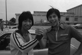
Peter Joe and Barry Hong at Mid-Summer festival at Strathcona Community Centre
Part of Paul Yee fonds
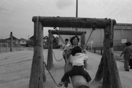
People on playground at Mid-Summer Festival at Strathcona Community Centre
Part of Paul Yee fonds
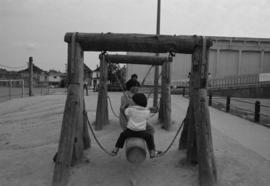
People on playground at Mid-Summer Festival at Strathcona Community Centre
Part of Paul Yee fonds
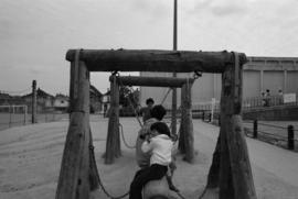
People on playground at Mid-Summer Festival at Strathcona Community Centre
Part of Paul Yee fonds

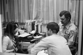
Pender Guy volunteers at an on-air broadcast from Strathcona Community Centre
Part of Paul Yee fonds

Pender Guy volunteers at an on-air broadcast from Strathcona Community Centre
Part of Paul Yee fonds

Pender Guy volunteers at an on-air broadcast from Strathcona Community Centre
Part of Paul Yee fonds
Part of Paul Yee fonds
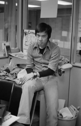
Pender Guy volunteer at an on-air broadcast from Strathcona Community Centre
Part of Paul Yee fonds

Pender Guy volunteer at an on-air broadcast from Strathcona Community Centre
Part of Paul Yee fonds

Pender Guy volunteer at an on-air broadcast from Strathcona Community Centre
Part of Paul Yee fonds
Item is an audio reel containing a recording of Pender Guy Program No. 88. Program contents transcribed from the Pender Guy Card Catalog: "1. Pender Guy Jingle 2. Standardize Introduction 3. Current affairs [Jim]: CBA Election - court ruling, UBC racist letter: Tel. interview with Heather Conn (UBC Staff) 4. Mid-break 5. Report: Strathcona Study: its social services and community needs, with Michael Goldberg, writer of the study and Johnathan Lau (interpreter) 6. Community news 7. Standard extro."
Item is an audio reel containing a recording of Pender Guy Program No. 55. Program contents transcribed from the Pender Guy Card Catalog: "1. Pender Guy Jingle 2. Introduction to Program - struggle to maintain mediocrity 3. Music - Divide and conquer from Grain of Sand 4. Social Report: Bill 65 at Strathcona 5. Asian-Am.: examines culture of life in Asian America, culture in USA 6. Mid-break [Rob/Tina] 7. Music - Street of London by Sam Siu 8. Excuse for having Super Pender Guy this week 9. Community News."
Item is an audio reel containing a recording of Pender Guy Program No. 54. Program contents transcribed from the Pender Guy Card Catalog: "1. Introduction - Pender Guy Jingle 2. Introduction to Program + Line up 3. SPOTA (Strathcona Property Owners and Tenants Association) Interview - "Neighbour to Neighbour" 4. Asian-Am - "Gold Watch' play 5. Mid-break 6. Chinese-Canadian History - Chinese Exclusion Act 7. Drama - Super Pender Guy 8. Community News."
Item is an audio reel containing a recording of Pender Guy Program No. 184. Program contents transcribed from the Pender Guy Card Catalog: "1. Pender Guy Jingle 2. Introduction 3. Music 4. What's happening - Strathcona Community Centre, CCC/CVC/UBC 5. Music 6. Kokuho Rose interview 7. Music 8. Extro."
Pender Guy Program No. 178 - Master
Item is an audio reel containing a recording of Pender Guy Program No. 178. Program contents transcribed from the Pender Guy Card Catalog: "1. Jingle 2. Line up 3. W5 issue - report on W5 controversy meeting - setting up of Vancouver Committee vs W5 4. Transition music 5. Development of Pender Street Bypass - Pender-Taylor connection, telephone interview with City Hall Engineer, David Rudberg - Chinatown/Downtown traffic 6. Introduction 7. Transition music 8. 'Bamboo Brew' - music, group member introduction 9. Fundraising Raffle review - winners announced 10. What's happening 11. sign off."
Pender Guy Program No. 176 - Master
Item is an audio reel containing a recording of Pender Guy Program No. 176. Program contents transcribed from the Pender Guy Card Catalog: "1. Introduction Music 2. Introduction Jingle 3. Line up 4. Current Affair - controversy of Lot C and D, Government selling lot to Strathcona Centre 5. Music 6. W5 Report (vs too many foreign students) - Dr. Joseph Wong's words, councilor of Chinese Canadian Society in Toronto (words against CTV W5 report) 7. What's happening 8. Community News 9. Music segments 10. Sign off."