Showing 494508 results

Archival description
Print preview View:

221332 results with digital objects Show results with digital objects

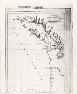
Carte de la parte de la cote nord-ouest de l'Amerique : recconnue pendant les etes de 1792, 1793 and 1794, depuis 29D 54' de Latitude Nord et 244D 33' de Longitude Orientale, jusqu'au Cap Douglas par 58D 52' de Latitude et 207D 20' de Longitude, par le Ca

Map shows the Pacific Coast from Prince William Sound in the north though the Queen Charlotte Islands, Vancouver Island, Port S. Francisco and Sn. Diego to Sn. Domingo in the south.

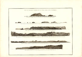
Vue de diverses parties de la côte nord-ouest d'Amérique

Item is a graphical plate from an atlas, showing views of Cape Scott, Scott Island, the entrance to Nootka Sound, Woody Point, the entrance to the Columbia River, and Point Barro de Arena. The item is a plate from a French reprinting of "A Voyage of Discovery to the North Pacific Ocean and round the world..." by George Vancouver.

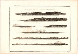
Vue de diverses parties de la côte nord-ouest d'Amérique

Item is a graphical plate from an atlas, showing views of Cape Mendocino, Cape Orford, Grenville Point, the entrance to the Straits of Juan de Fuca and the coastline south of Cape Flattery. The item is a plate from a French reprinting of "A Voyage of Discovery to the North Pacific Ocean and round the world..." by George Vancouver.

Bastion [Nanaimo] photographs

File contains photographs of the bastion; coal mining sites and activities; portraits of unidentified people; native Indians, including Chief Napoleon; Nootka Sound; Tofino; Clayoquot Bay; and Nanaimo schools, streets and harbour views.

Hubert Lindsay Cadieux fonds

  • AM782
  • Fonds
  • [18--] - 1981

The fonds includes Cadieux's research notes; navigational reference notes; numerous photographs of ships, shipwrecks and light stations as well as towns, harbours and other scenes in British Columbia; correspondence, photographs of family and friends and other personal records; scrapbooks of newspaper clippings; collected publications on maritime topics; and two completed manuscripts, "British Columbia Towboats" and "Manned Lighthouses of British Columbia".

Cadieux, Hubert Lindsay

O.B. Allan Ltd. fonds

  • AM1385
  • Fonds
  • [18-?] - 1965, 1971

The fonds consists of 42 photographs and negatives, mainly of the O.B. Allan store.

Allan, Oscar Bruce

Religious and educational books

File includes Historical and Miscellaneous Questions for the Use of Young People, and The Constitution of the Presbyterian Church of the United States of America.

[Sketches]

File includes tracing of sketch of Survey of D.L. 185, signed L.A. Hamilton; unsigned tracing of D.L. 185 from Reserve to Granville; sketch on tracing paper, signed John Strathern D.L.S.; unsigned tracing of Block 192 1st Avenue and 9th Avenue marked in pencil; paper sketch of contours on Howe Street from Dunsmuir to Robson; unsigned paper sketch of survey, 16th Sept. 1886; unsigned tracing showing D.L. 315 to 326 with dotted line for "False Creek Trail;" unsigned surveys, Burrard Inlet, October 1865, and False Creek; paper sketch, unsigned, Lots 200A and 302; unsigned paper sketch of lot 181; pen and ink sketch, "original survey of government reserve."

Results 151 to 200 of 494508