Showing 1505 results

Archival description
City of Vancouver Archives technical and cartographic drawing collection Item
Print preview View:

1194 results with digital objects Show results with digital objects

False Creek, Vancouver, B.C.

Item is a map showing street names and major landmarks around False Creek during Expo 86. Major pavilions on the fair site are labeled. An index map in the lower right-hand corner of the map shows the location of the primary map in relation to the rest of Greater Vancouver and the United States. The map also includes a short chronology of the history of False Creek and Granville Island. The cover of the envelope depicts a smaller version of the map.

False Creek Indian Reserve, Burrard Inlet, B.C. : compiled from plans of record in the Dept. [Department] of Indian Affairs

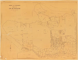
Map is a plan of the Kitsilano Point area showing the area currently known as Kitsilano Beach and Vanier Park, and streets and blocks between Maple Street and Centre Street (Granville Street) and First Avenue to Third Avenue. The plan shows in detail the land designated as the Kitsilano Indian Reserve, including the original reserve as constituted prior to Confederation, the addition made by the Joint Commission on 15th June 1877, and land leased to Harrison Mills T. and T. Co. Map also shows the location of Canadian Pacific Railway land, the Vancouver and Lulu Island Railroad, Rat Portage Lumber Company, Tait's Mill, the Third Avenue Bridge and bathing beach. Annotations in ink indicate the location of Sam Greer's house and garden and nearby spring on what is now known as Kitsilano Beach. A note made on the front of the map by J.S. Matthews in 1930 reads "This blueprint was given me about 1928 by Mrs. J.Z. Hall, dau[ghter] of Sam Greer, and had evidently been attached to a letter from Hon. H.H. Stevens, M.P. to Mr. Greer, dated Ottawa, May 15, 1923 with enclosure from Dr. Scott Indian Office, Ottawa, 9th May 1923. The notation "House" and "Garden" were, when first received by me, on pencil, rudely written, perhaps by Mr. Greer himself (quite and most likely). The marks were inked in with Indian ink by me."

Composite aerial photographic map of the greater Vancouver area

Item is a map made up of a collage of aerial photogrpahs showing the greater Vancouver area bounded approximately by the North Shore Mountains in the north, the Gulf of Georgia in the west, the Burnaby-Coquitlam border in the east, and the Fraser River and parts of Surrey and Lulu Island (Richmond) in the south. Neither the photograph or who was responsible for the composite is identified.

City of Vancouver [park sites June/80]

Map is a City Engineering Department base map of Vancouver, with parks hand-coloured in green. Shows city blocks and Canadian Pacific, Canadian National and Great Northern Railway lines. Golf courses, hospitals, schools, theatres and other structures are identified. "Metric Vancouver" and "Guide Map 15" appear in the bottom right corner of the map.

City of Vancouver

Map is a City Engineering Department base map of Vancouver, showing city blocks and Canadian Pacific, Canadian National and Great Northern Railway lines. Parks, golf courses, hospitals, schools, theatres and other structures are identified. "Metric Vancouver" and "Guide Map 15" appear in the bottom right corner of the map.

Vancouver 1886-1986 : yesterday, gateway to the Pacific : today, crossroads of the world

Map is a souvenir poster reproduced from an original in the National Map Collection, Public Archives of Canada. The map shows lot numbers and lot boundaries for the city of Vancouver as of June 1886. The original map was entitled "Plan of the city of Vancouver, Western Terminus of the Canadian Pacific Railway".

Map of portion New Westminster District

Item is a heavily-amended copy of a map illustrating intended land settlement and subdivision in 1877 in the future sites of Vancouver, Burnaby and the North Shore, from an area bordering on English Bay to an area bordering on North Arm. Also shown are bodies of water, Hastings & Granville Road, and the settlements of Hastings and Granville. Annotations by J.S. Matthews in 1954 made on the copy are tracings in white pen and darkening the background to improve the copy.

Cheakamus power survey for City of Vancouver, 1930-1931 : general plan & profile : sheet no. 1 [Garibaldi Lake to Cheakamus Lake] to accompany report of E.A. Cleveland dated November 30th 1931

Map is a plan showing the location of power houses, dams and pipes for the Garibaldi-Daisy Lake development, Cheakamus Lake-McGuire, McGuire-Brandywine, Cheakamus Canyon and Daisy Lake Dam areas. Map created to accompany E.A. Cleveland's "Report on a Preliminary Investigation of the Cheakamus River Power Possibilities made for the City of Vancouver."

Cheakamus power survey for City of Vancouver, 1930-1931 general plan and profile : sheet no. 1 [Garibaldi Lake to Cheakamus Lake] to accompany report of E.A. Cleveland dated November 30th 1931

Map is a plan showing the location of power houses, dams and pipes for the Garibaldi-Daisy Lake development, Cheakamus Lake-McGuire, McGuire-Brandywine, Cheakamus Canyon and Daisy Lake Dam areas. Map created to accompany E.A. Cleveland's "Report on a Preliminary Investigation of the Cheakamus River Power Possibilities made for the City of Vancouver."

Cheakamus power survey for City of Vancouver, 1930-1931 : mass curves showing Cheakamus River discharge : sheet no. 2 to accompany report of E.A. Cleveland dated November 30th 1931

Map consists of a graph showing the discharge in acre feet of the Cheakamus River at Watson, 1917-1926, and the Cheakamus River near Daisy Lake, 1926-1930. Map created to accompany E.A. Cleveland's "Report on a Preliminary Investigation of the Cheakamus River Power Possibilities made for the City of Vancouver." Map has been numbered Tube 55.

Cheakamus power survey for City of Vancouver, 1930-1931 : plan showing proposed development at Cheakamus Lake : sheet no. 3 to accompany report of E.A. Cleveland dated November 30th 1931

Map is a plan of the proposed development of the Cheakamus Lake for hydroelectric power. Includes a capacity diagram of Cheakamus Lake with dam at section A-B and a plan of the proposed dam site. The map also shows elevations and types of terrain. Map created to accompany E.A. Cleveland's "Report on a Preliminary Investigation of the Cheakamus River Power Possibilities made for the City of Vancouver." A note on the map reads "Traverse from Sta. 257-50 to Sta. 371-10 by C.W. Williams 1923, Cheakamus Lake from plan by Williams (1923) except soundings as shown." Map has been numbered Tube 56.

Cheakamus power survey for City of Vancouver, 1930-1931 : plan showing proposed development near McGuire and Brandywine : sheet no. 4 to accompany report of E.A. Cleveland dated November 30th 1931

Map is a plan showing the proposed hydroelectric development near McGuire and Brandywine Creek. Map was created to accompany E.A. Cleveland's "Report on a Preliminary Investigation of the Cheakamus River Power Possibilities made for the City of Vancouver." Map has been numbered Tube 57.

Cheakamus power survey for City of Vancouver, 1930-1931 : proposed storage reservoir at Daisy Lake : sheet no. 5 to accompany report of E.A. Cleveland dated November 30th 1931

Map is a plan of the proposed storage reservoir at Daisy Lake on the Cheakamus River. The map includes a plan of the topography of the proposed dam site, a log of borings, and a capacity diagram at Daisy Lake Reservoir. Also included are elevations, power stations, pipelines and the Pacific Great Eastern Railway line. The map was created to accompany E.A. Cleveland's "Report on a Preliminary Investigation of the Cheakamus River Power Possibilities made for the City of Vancouver." Map has been numbered Tube 58.

Cheakamus power survey for City of Vancouver, 1930-1931 : plan showing proposed development near Mile 19 - P.G.E. Rly. : sheet no. 6 to accompany report of E.A. Cleveland dated November 30th 1931

Map is a topographical plan showing the proposed hydroelectric development on the Cheakamus River near Mile 19, Pacific Great Eastern Railway. Indicated on the map are the locations of tunnels, dams, by-passes, pipelines, the railway line, and the power station for the Cheakamus Canyon development. The map was created to accompany E.A. Cleveland's "Report on a Preliminary Investigation of the Cheakamus River Power Possibilities made for the City of Vancouver." Map has been numbered Tube 59.

Cheakamus power survey for City of Vancouver, 1930-1931 : plan showing proposed diversion works near Mile 19 - P.G.E. Rly., detail sheet : sheet no. 7 to accompany report of E.A. Cleveland dated November 30th 1931

Map is a topographical plan showing the proposed diversion works on the Cheakamus River near Mile 19, Pacific Great Eastern Railway. Indicated on the map are the locations of tunnels, dams and the railway line. The map was created to accompany E.A. Cleveland's "Report on a Preliminary Investigation of the Cheakamus River Power Possibilities made for the City of Vancouver." Map is numbered Tube 60.

Cheakamus power survey for City of Vancouver, 1930-1931 : topographical plan from Alpha Lake to Cheakamus River, above Mile 34, P.G.E. Rly. : sheet no. 8 to accompany report of E.A. Cleveland dated November 30th 1931

Map is a topographical plan showing the area from Alpha Lake to Cheakamus River, above Mile 34, Pacific Great Eastern Railway. Indicated on the map are the locations of the Mons Gauging Site, a suggested dam site, trails, the old wagon road, the railway line, and Millar Creek. The map was created to accompany E.A. Cleveland's "Report on a Preliminary Investigation of the Cheakamus River Power Possibilities made for the City of Vancouver." Map has been numbered Tube 61.

Cheakamus power survey for City of Vancouver, 1930-1931 : plan showing topography southward along a line from Cheakamus River near Mile 34, P.G.E. Rly. : sheet no. 9 to accompany report of E.A. Cleveland dated November 30th 1931

Map is a topographical plan of the Cheakamus River area from a point southward near Mile 34, Pacific Great Eastern Railway, showing elevations and a trail. The map was created to accompany E.A. Cleveland's "Report on a Preliminary Investigation of the Cheakamus River Power Possibilities made for the City of Vancouver." Map has been numbered Tube 62.

Cheakamus power survey for City of Vancouver 1930-1931 : plan showing proposed development from Garibaldi Lake to Daisy Lake : sheet no. 10 to accompany report of E.A. Cleveland dated November 30th 1931

Map is a topographical plan showing a proposed hydroelectric development in the Cheakamus River area, between Garibaldi Lake and Daisy Lake, and a profile along the tunnel and pipeline route. Included on the map are Daisy Lake, Garibaldi Lake, Cheakamus River, various creeks, including Parnassus Creek and Scott Creek, bluffs, and ponds. Also indicated on the map are the locations of a pipeline, tunnel and tunnel intake, the Daisy Lake Trail and other trails, a construction shaft, proposed dam, proposed Daisy Lake Reservoir, and the power station for the Garibaldi-Daisy Lake Development. The map was created to accompany E.A. Cleveland's "Report on a Preliminary Investigation of the Cheakamus River Power Possibilities made for the City of Vancouver."

It might have been Albert City, 1858, New Georgia 1792 : it was Granville, 1870, British Columbia, 1871 : it is Vancouver, 1886, British Columbia, 1871 : it is Vancouver, 1886, Canada, 1867

Item is a map compiled and drawn by J.S. Matthews, City Archivist showing historic place names of Vancouver and the North Shore and listing some historic Burnaby names. A note in the bottom left hand corner reads: "Memorada. The precise location of "Albert City" is unknown, Narveaz was first; 150 years passed before his name was given to a landmark. His vessel's name "Santa Saturnina" has never been applied to anything at all."

South Western Districts [of British Columbia]

Item is a map with four accompanying inset maps. The area depicted on the main map, entitled "Commercial and Visitors Map" is the area of southwestern British Columbia, encompassing most of Vancouver Island, the Coast and New Westminster land districts, and portions of the Kamloops and Lillooet land districts. The northern end of Vancouver Island is depicted in Inset maps A and A1, inset map B depicts the north-western portion of Washington State, and a small index map of North America shows the continental location of the area depicted by the main map.

The information included in the map is: physical features, including topography; boundaries of land districts and divisions; transportation routes; logging status; dominant wildlife species; and proposed and existing economic activity in various areas.

Carte de la parte de la cote nord-ouest de l'Amerique : recconnue pendant les etes de 1792, 1793 and 1794, depuis 29D 54' de Latitude Nord et 244D 33' de Longitude Orientale, jusqu'au Cap Douglas par 58D 52' de Latitude et 207D 20' de Longitude, par le Ca

Map shows the Pacific Coast from Prince William Sound in the north though the Queen Charlotte Islands, Vancouver Island, Port S. Francisco and Sn. Diego to Sn. Domingo in the south.

Carte particuliere de la cote du Nord-Ouest de l' Amerique reconnue par les fregates Francaises la Boussole et l'Astrolabe en 1786, 2e. feuille

Item is a map showing the Pacific Coast of British Columbia and Washington and Oregon states as surveyed by French explorer Jean-Francois de Galaup (Laperouse) in 1786, and the routes of his ships Astrolabe and Boussole. The map shows the Pacific coastline from Cap Rond (Tillamook Head) in Oregon at latitude 45 degrees and 40 minutes in the south to Baeie de Clonard (Beresford Bay, northwestern tip of Haida Gwaii) in British Columbia at latitude 54 degrees and 10 minutes in the north. Other major place names on the map include Nootka, Pointe Boisee, Baie St. Louis, Iles de Sartine, Mont Fleurieu, Cap Fleurieu, Cap Hector, Mont de la Touche, Baie de la Touche, and Baie de Clonard. Vancouver Island is shown as part of the mainland. Map includes latitudes and longtitudes as well as indication of elevations. Map is a plate from the "Atlas de Voyage de la Perouse".

Vue de diverses parties de la côte nord-ouest d'Amérique

Item is a graphical plate from an atlas, showing views of Cape Scott, Scott Island, the entrance to Nootka Sound, Woody Point, the entrance to the Columbia River, and Point Barro de Arena. The item is a plate from a French reprinting of "A Voyage of Discovery to the North Pacific Ocean and round the world..." by George Vancouver.

Vue de diverses parties de la côte nord-ouest d'Amérique

Item is a graphical plate from an atlas, showing views of Cape Mendocino, Cape Orford, Grenville Point, the entrance to the Straits of Juan de Fuca and the coastline south of Cape Flattery. The item is a plate from a French reprinting of "A Voyage of Discovery to the North Pacific Ocean and round the world..." by George Vancouver.

Map and information concerning the City and District of New Westminster and the Province of British Columbia

Item is a pamphlet with a map on one side and text on the other. The map shows the location of churches, school, canaries, sawmills, backyards, tanneries, woolen mills, hatcheries, roads, and railways on a map which depicts the area of Greater Vancouver from the Gulf of Georgia east to Harrison Lake and south to the United States border. The verso contains information concerning the city and district of New Westminster, with individual panels on the municipalities of Delta, Chilliwhack [sic], Surrey, Langley, and Delta, and the City of New Westminster, the town of Harrison Hot Springs and the province.

City of Vancouver : Canadian Pacific town site

Primary map shows lot numbers and boundaries, streets, fire limits and "soundings in feet" (in English Bay, Burrard Inlet, Coal Harbour and False Creek) in downtown Vancouver, Stanley Park and parts of Kitsilano and Fairview. The ancillary maps show an "Index plan of Vancouver, B.C.", an "Index plan of [Vancouver] city limits" and "Canadian Pacific Mail Steamship Lines" (a map of Canadian Pacifc steamship routes around the world). On recto, the item also includes a description of Stanley Park and an illustration of Vancouver's inner harbour. On verso, the item includes descriptions of major Vancouver residences, imports, exports, businesses and other landmarks.

B.C. Electric Railway lines completed and under construction

Map shows B.C. Electric Railway lines completed (in red), B.C. Electric Railway lines under construction (in yellow), lot numbers and major roads in the Greater Vancouver area from Burrard Inlet in the north to the north arm of the Fraser River in the south and from New Westminster in the east to Point Grey in the west.

Vancouver, B.C.

Map shows major roads, parks, landmarks and tourist attractions in Vancouver and parts of West Vancouver, North Vancouver and Burnaby. The map shows the area from Grouse Mountain in the north to Vancouver International Airport in the south and from Burnaby Lake in the east to Lighthouse Park and the University Endowment Lands in the west

Results 151 to 200 of 1505