
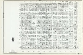
Plan of a 9.783 acre portion of Kitsilano Indian Reserve, District Lot 3610, Group one, New Westminster District [annotated]

Plan of a 9.783 acre portion of Kitsilano Indian Reserve, District Lot 3610, Group one, New Westminster District [annotated]

Plan of a 9.783 acre portion of Kitsilano Indian Reserve, District Lot 3610, Group one, New Westminster District [annotated]

British Columbia : an historical illustrated map commemorating two centenaries, 1867-1967, 1866-1966

Road maps

Greater Victoria provincial electoral districts
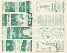
Let's go see! Inside Vancouver

Lower Mainland provincial electoral districts
![McRoberts Island [Sea Island]](/uploads/r/null/6/9/6981a571c6d3102ee36ac270cce0eca9727531a3a9b4dd09f46f6f61adbbadbe/b8c696f2-5181-4f84-9e76-6420f9b2e916-Map800_142.jpg)
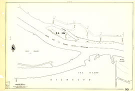
McRoberts Island [Sea Island]
![Plan to accompany by-law no. [Blank] being a by-law to amend by-law no. 4054 being the street nam...](/uploads/r/null/3/a/d/3ad2e1a740be487ac9cdd1a7e10ac6cbe15cda433b0937bde9a0837696e4148a/802101ef-808b-4353-a5fe-3100da56eeb7-MAP71c_142.jpg)
Plan to accompany by-law no. [Blank] being a by-law to amend by-law no. 4054 being the street naming by-law
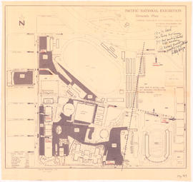
Pacific National Exhibition grounds plan : parking available for proposed arena

Vancouver, British Columbia

Dispersal routes for the Vancouver zone

Maps of downtown Vancouver and the Fraser Valley, detail maps of traffic interchanges, and general information

Street map of Greater Vancouver, B.C.
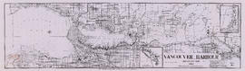
Vancouver Harbour, British Columbia, 1964
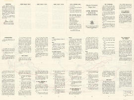
Target area civil defence survival instructions

North Arm Road, 1876. North Arm, Fraser River

Front page and index map

The service route to - from - through industrial southwestern British Columbia

Vancouver South, British Columbia

Map of downtown Vancouver

Sheet 61 : Cypress Street to Oak Street and Forty-first Avenue to Thirty-third Avenue

Sheet 62 : Cypress Street to Oak Street and Forty-ninth Avenue to Forty-first Avenue

Sheet 10 : Clark Drive to Nanaimo Street and Frances Street to Burrard Inlet

Sheet 12 : Nanaimo Street to Cassiar Street and Pender Street to McGill Street

Sheet 14 : Cassiar Street to Boundary Road and Pender Street to Eton Street

Sheet 20 : Main Street to Clark Drive and Great Northern Way to Prior Street

Sheet 25 : Blanca Street to Jericho Beach and Fourth Avenue to Locarno Beach

Sheet 26 : University Endowment Lands to Blanca Street and Fourth Avenue to Spanish Banks Beach

Sheet 29 : Balaclava Street to Maple Street and Fourteenth Avenue to Third Avenue

Sheet 31 : Oak Street to Main Street and Sixteenth Avenue to Fourth Avenue and False Creek

Sheet 35 : Rupert Street to Ardley Avenue and Grandview Highway to Fifth Avenue

Sheet 38 : Nanaimo Street to Rupert Street and Twenty-second Avenue to Grandview Highway

Sheet 41 : Ontario Street to Inverness Street and Twenty-eighth Avenue to Sixteenth Avenue

Sheet 42 : Oak Street to Ontario Street and Twenty-eighth Avenue to Sixteenth Avenue

Sheet 49 : Arbutus Street to Oak Street and Thirty-third Avenue to Laurier Avenue

Sheet 57 : Nanaimo Street to Doman Street and Joyce Street and Forty-ninth Avenue to Forty-first Avenue

Sheet 59 : Quebec Street to Inverness Street and Forty-seventh Avenue to Thirty-seventh Avenue
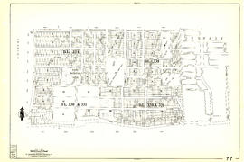
Sheet 77 : Kerr Street to Greenall Avenue and Southeast Marine Drive to Asquith Avenue

Sheet 79 : Gladstone Street to Kerr Street and North Arm of Fraser River to Bobolink Avenue

Sheet 89 : North Arm of Fraser River to Southwest Marine Drive and Barnard Street
Sheet 90 : Carrington Street to Macdonald Street and Richmond to Celtic Avenue

District lot boundaries within the City of Vancouver, British Columbia

Index to 400 ft. scale section maps
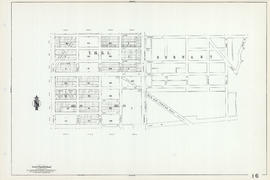
Section 9 : Clark Drive to CPR right-of-way to Main Street to Prior Street
Section 16 : Boundary Road to Kitchener Street to Rupert Street to Fifth Avenue
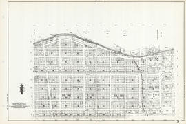
Section 19 : Nanaimo Street to Ferndale Street to Clark Drive to Second Avenue

Section 21: False Creek between Main Street and D.L. 526

Section 22: False Creek between CPR yards and Kitsilano Point