
Early stages of carving totem pole
- COV-S477-3-F111-: CVA 775-58
- Item
- [1986 or 1987]
Part of City of Vancouver fonds
Early stages of carving totem pole
Part of City of Vancouver fonds

Part of City of Vancouver fonds
Part of City of Vancouver fonds

Part of City of Vancouver fonds

Part of City of Vancouver fonds

Part of City of Vancouver fonds

Burrard Bridge after repainting
Part of City of Vancouver fonds

Granville Street Bridge lighting sign
Part of City of Vancouver fonds

Part of City of Vancouver fonds
Part of City of Vancouver fonds

Early stage of Roedde House restoration
Part of City of Vancouver fonds

Burrard Bridge after repainting
Part of City of Vancouver fonds

Civic mace replating, presentation to Mayor Michael Harcourt
Part of City of Vancouver fonds

Gordon Campbell and unidentified man cutting ribbon at Portal Park opening
Part of City of Vancouver fonds

Proposed industrial subdivision - Joyce and Vanness
Part of City of Vancouver fonds
![[View of Mount Pleasant]](/uploads/r/null/0/c/9/0c9db5e81df211f273f5e890c4cf2f482734489cf47c53831e2f430410336c9b/259201ec-18df-4a3e-9317-7b6aa211e33b-CVA808-9_142.jpg)
Part of City of Vancouver fonds
![[House at] 743 East Pender Street](/uploads/r/null/c/7/c7cb8ee7375a3f7c85b16d6bcac69252f03f7c76ae6b935d36a1953256db0d03/347d091d-7104-4d2a-813d-8f7daf51862c-A61546_142.jpg)
[House at] 743 East Pender Street
Part of City of Vancouver fonds
![[House at 727] Keefer Street](/uploads/r/null/c/4/c41bd7532c24c871c2ed8be83f67d581b21d06c4e1819f00079cee73d5982dea/4602d0e0-b009-4c67-8272-e4286b496b86-A61552_142.jpg)
Part of City of Vancouver fonds
![[Buildings at] 886-898 Union Street](/uploads/r/null/0/9/0998c98e83ff573660605fb2e05e845a11f9807872f6f8eef620b2160352a8aa/78776bb6-68ae-449c-b26d-449b666e881b-A61555_142.jpg)
[Buildings at] 886-898 Union Street
Part of City of Vancouver fonds
![[Buildings at] 606 Union Street](/uploads/r/null/5/5/556bc3293559172a8a9849d9d55ac756b4c21caeeb58ffa5b2f607753cb9d958/61a17ec4-7c57-489e-8c5c-7c0726a3c713-A61558_142.jpg)
[Buildings at] 606 Union Street
Part of City of Vancouver fonds
![[Buildings at] 606 Union Street](/uploads/r/null/b/0/b057b3e56c0a625078b403bddd58250fc8e9ae22c257d73f648900eaaf78e740/70639922-761f-473b-84b4-065c3025f125-A61559_142.jpg)
[Buildings at] 606 Union Street
Part of City of Vancouver fonds

Project 2 : generalized plan of redevelopment
Part of City of Vancouver fonds
Item is the index map showing the boundaries of the various sub-areas of redevelopment project no. 2. The map shows the boundaries of clearance and redevelopment areas, the proposed street system and the proposed land use for the area from Burrard Inlet in the north to 16th Avenue in the south and from Nanaimo Street in the east to Arbutus Street in the west.

Project 2, part of area "a" : condition of buildings
Part of City of Vancouver fonds
Item is a map showing the condition of buildings (ranging from very good to very poor) within the boundaries of project 2, area "a". The map also shows the boundaries of project 2 clearance, the boundaries of project 1 clearance and the realignment of Raymur Avenue.

Project 2, part of area "a" : existing utilities, water and sewer
Part of City of Vancouver fonds
Item is a map showing the configuration of water and sewer services in project 2 area "a". The map depicts the water pipes (10" and over), the sewers (15" and over), and the direction of sewer flow.

Marpole (east half; building outlines)
Part of City of Vancouver fonds
Item consists of a map depicting the outlines of buildings in the Marpole neighbourhood.
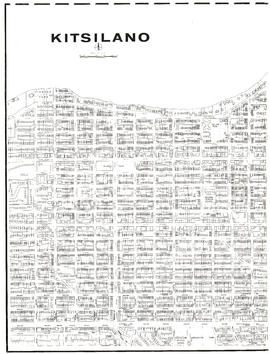
Kitsilano (west half; building outlines)
Part of City of Vancouver fonds
Item consists of a map depicting the outlines of buildings in the Kitsilano neighbourhood.

Part of City of Vancouver fonds
Item consists of a map depicting the outlines of buildings in the Downtown area of the city.

Part of City of Vancouver fonds
Item consists of a map depicting Vancouver's major road, the original Skytrain line and location of stations.
![City of Vancouver B.C. area map [Cartier St. to 49th Ave. to Wallace St. to Fraser River]](/uploads/r/null/b/9/0/b90512d5b7ab999c429946e004afaeefa347e648d05cbe127e548941cf053492/4bf26a05-6451-4c58-be1b-4491a36347e0-LEG1493_142.jpg)
City of Vancouver B.C. area map [Cartier St. to 49th Ave. to Wallace St. to Fraser River]
Part of City of Vancouver fonds
Item consists of a map depicting streets, transportation infrastructure, parks, harbour headlines and other geographic features.
![City of Vancouver B.C. area map [Inverness St. to 37th Ave. to Granville St. to 57th Ave.]](/uploads/r/null/b/b/b/bbb5627e84fb0e74ba863c698c350f1c776909c66fe285c49945f91a0bde6e48/94cc8c2d-2d95-4552-a8e4-3a917b38ed69-LEG1493_142.jpg)
City of Vancouver B.C. area map [Inverness St. to 37th Ave. to Granville St. to 57th Ave.]
Part of City of Vancouver fonds
Item consists of a map depicting streets, transportation infrastructure, parks, harbour headlines and other geographic features.

Strathcona (building outlines)
Part of City of Vancouver fonds
Item consists of a map depicting the outlines of buildings in the Strathcona neighbourhood.

Part of City of Vancouver fonds
Item shows locations and exteriors of buildings in the area bounded by Oak Street, Yukon Street, Broadway, and 16th Avenue.
![C.B.D. [Central Business District] trip trace density chart](/uploads/r/null/6/b/4/6b4dfcd5710a8add68045b374b1df6e0649e8577a53d23070c9494276c76c3fd/0e0776f3-ca72-4c99-8121-6e7293b90cee-LEG26_142.jpg)
C.B.D. [Central Business District] trip trace density chart
Part of City of Vancouver fonds
Item is a chart produced as part of the Metropolitan Highway Planning Study, containing five maps of the downtown Vancouver area showing trip traces per square mile for 1955, projected trip traces for 1976, and projected trip traces for three test freeway networks.

City of Vancouver, British Columbia : 1954 land use
Part of City of Vancouver fonds
Item shows dwelling types and commercial, industrial, and agricultural uses.

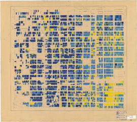
Age of buildings : Main Street to Clark Drive and Prior Street/Venables Street to Broadway
Part of City of Vancouver fonds
Sheet is annotated to show the boundary of Area 'H' for the Vancouver Redevelopment Study.

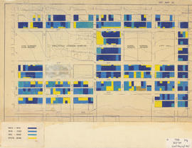
Age of buildings : Arbutus Street to Oak Street and Odgen Avenue to Broadway
Part of City of Vancouver fonds

Age of buildings : Slocan Street to Boundary Road and 5th Avenue to 22nd Avenue
Part of City of Vancouver fonds
Part of City of Vancouver fonds

Age of buildings : Crown Street to Blenheim Street and 41st Avenue to 55th Avenue
Part of City of Vancouver fonds
Age of buildings : Blanca Street to Discovery Street and 10th Avenue to 16th Avenue
Part of City of Vancouver fonds
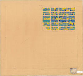
Age of buildings : Clark Drive to Slocan Street and Hastings Street to 6th Avenue
Part of City of Vancouver fonds

Part of City of Vancouver fonds

Age of buildings : Clark Drive to Slocan Street and Powell Street/Wall Street to Hastings Street
Part of City of Vancouver fonds

Age of buildings : Knight Street to Slocan Street/Wales Street and 22nd Avenue to 37th Avenue
Part of City of Vancouver fonds

Possible civic square development for downtown Vancouver
Part of City of Vancouver fonds
Item is a drawing showing existing civic structures, possible new structures, and a proposed civic square.
![City of Vancouver [Distribution of retail sales and receipts of service establishments - 1951]](/uploads/r/null/3/9/7/3970537d0d8596140313dc84373e73334a52dfd423812f8ed746f90efd77b050/00738a9c-eac0-4b16-8878-f50deae7c4ee-LEG26_142.jpg)
City of Vancouver [Distribution of retail sales and receipts of service establishments - 1951]
Part of City of Vancouver fonds
Item is a base map of Vancouver which has been annotated using 1951 Census of Canada data to show retail sales and service receipts for each census tract area. An annotation reads: "Source: 1951 Census of Canada Bulletin CT13".
Government precinct : age of buildings
Part of City of Vancouver fonds
Item is a map annotated to show age of buildings in the area bounded by Oak Street, Yukon Street, Broadway, and 15th Avenue. Base map shows streets and topographical contour lines.
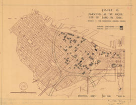
Figure 10 : parking as the major use of land in 1954
Part of City of Vancouver fonds
Map is a plan of downtown Vancouver showing parking structures and parking lots in the area between Jervis Street and Main Street and Burrard Inlet and Nelson Street. The source of the map is indicated as 'The Downtown Parking Report'. Note written in the bottom right corner of the map reads "B 1960 Jan., Traffic Plans, small folder."

Households and population by enumeration areas : 1966 census
Part of City of Vancouver fonds
Item is a map annotated to show households and population for the West End and downtown core east to Main Street. Base map shows streets.
![City of Vancouver [Existing super-markets : date of erection, size and location]](/uploads/r/null/c/9/9/c994b91e283c9d37d539b5381734a5b8dd287c7cc8da9ba54b10a82d884e42b2/99137e02-fef1-48fe-8563-9abd1c74c42f-LEG1202_142.jpg)
City of Vancouver [Existing super-markets : date of erection, size and location]
Part of City of Vancouver fonds
Item is a map annotated to show major arterial roads and location, size, and building date of supermarkets. Base map is numbered C.B.M. 1500 and shows roads, golf courses, and parks.