![[Three men on float in False Creek conducting an electrolysis survey]](/uploads/r/null/3/4/34fb65f698b12e6e882dc2f61052ccb8b788ce1aaa2659d7a4e2ec32e9af3b7c/f941fe0a-c10f-46c3-8e86-8b895f754edb-A08611_142.jpg)
[Three men on float in False Creek conducting an electrolysis survey]
- AM54-S4-: LGN 1269.2
- Item
- [6 May 1914]
Part of Major Matthews collection
[Three men on float in False Creek conducting an electrolysis survey]
Part of Major Matthews collection

Part of Major Matthews collection
![[Three wooden penstocks for Buntzen Lake Power Plant number one]](/uploads/r/null/6/5/655ea1a0fba5107f7ad5e020e513012a0908fe652a9d64188c08ee0a285867c8/0ddaba6e-e885-4d5b-9918-0544fd617c33-A04785_142.jpg)
[Three wooden penstocks for Buntzen Lake Power Plant number one]
Part of Major Matthews collection
![[The crew after erecting the last B.C.E.R. transmission line pole]](/uploads/r/null/4/e/4e5fa7c2af32de7bcfb459fec9ef00fa7d6c111b9aee204c48813790ec241174/2941a0b9-1086-4d57-83a3-0ffe93d73607-A26882_142.jpg)
[The crew after erecting the last B.C.E.R. transmission line pole]
Part of Major Matthews collection
Group portrait showing Joseph Rogers, Robert Walker and others
![[Rebuilding of upper end of penstocks 1 to 4 for Buntzen Lake Power Plant number one]](/uploads/r/null/8/4/844e14f822de3bca266a2bf16cbf6be9a4f54ed766bf7799153419f8b36e9e89/dc14131d-56c6-4734-b755-29be665cc9a7-A08126_142.jpg)
[Rebuilding of upper end of penstocks 1 to 4 for Buntzen Lake Power Plant number one]
Part of Major Matthews collection
Photograph shows large trench between pipes.
![[Rebuilding of upper end of penstocks 1 to 4 for Buntzen Lake Power Plant number one]](/uploads/r/null/c/5/c519be719f688af9cf39fc56b72376963fb9266c1d058e8bab034ef4fae920b9/72defdfc-657a-4fa5-9a08-8bc8e625298f-A08127_142.jpg)
[Rebuilding of upper end of penstocks 1 to 4 for Buntzen Lake Power Plant number one]
Part of Major Matthews collection
Photograph shows various sections of pipe on ground.
![[Replacement of upper sections of wood stove penstocks for Buntzen Lake Power Plant number one]](/uploads/r/null/9/a/9aa6345ec3ea2dbfb88feb42f77272ceb33931d54fa5f6544e228aeb438d7ccc/6520cc8b-5470-4e23-bff3-32ce9de132c9-A08130_142.jpg)
[Replacement of upper sections of wood stove penstocks for Buntzen Lake Power Plant number one]
Part of Major Matthews collection
Photograph shows partially excavated pipes in foreground and part of Indian Arm in the distance.

Part of Major Matthews collection

Part of Major Matthews collection
Part of Major Matthews collection
Photograph is a copy of a technical drawing produced by the Pelton Water Wheel Company.
![Bearing of a gland for 72" butterfly valve [used for Buntzen Lake Power Plant number two]](/uploads/r/null/8/f/8ff4041d21a05f6de736ab0028bebb89452ca132c8b84817dea545bdc3c2fd05/0f38ab06-0577-4bc0-9bab-79dc280b2182-A08531_142.jpg)
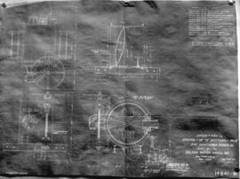
Bearing of a gland for 72" butterfly valve [used for Buntzen Lake Power Plant number two]
Part of Major Matthews collection
Photograph negative is a copy of a technical drawing produced by the Pelton Water Wheel Company.

Buntzen-Coquitlam hydro-electric development - Key map
Part of Major Matthews collection
Photograph negative is a copy of a technical drawing showing profiles of hydraulic tunnels for the Coquitlam Dam and the Buntzen Lake Power Plant number two; and of a map showing the Lower Mainland area. Negative was created in order to produce lantern slides of the two images.
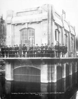
Canadian Society of Civil Engineers, Vancouver branch visit to Lake Buntzen, B.C.
Part of Major Matthews collection
Photograph shows a group of men assembled behind railing of gate house of Buntzen Lake Power Plant number two.
![[Wires outside electrical power house]](/uploads/r/null/3/5/352e42fd6cdd414dc9e116735754ce7d76fb3f8b68c9fb0a9bb0d7014bad526f/6621c34c-9264-4cf3-9389-5d26135d5bdd-A04807_142.jpg)
[Wires outside electrical power house]
Part of Major Matthews collection
![[Workers, scaffolding and machinery in excavated area for Buntzen Lake Power Plant number one]](/uploads/r/null/4/a/4ac99e47bd2fd1e3ed147b2513f2c5df2287b5646d624cf2f7a00e06dfc0e3b7/c95312c2-fa80-4506-8d64-7a91c91b97a3-A04800_142.jpg)
[Workers, scaffolding and machinery in excavated area for Buntzen Lake Power Plant number one]
Part of Major Matthews collection
![[View of partially constructed Buntzen Lake Power Plant number two from Indian Arm]](/uploads/r/null/a/5/a534f5a79a38e36cde2535c1342a16895deb9afe76334497ac026bfdc6df90a1/ba081f5d-fbc1-4a5d-b456-5662f381ba7a-A08438_142.jpg)
[View of partially constructed Buntzen Lake Power Plant number two from Indian Arm]
Part of Major Matthews collection
![Cylinder support for 6'-6" needle intake valve [used for Buntzen Lake Power Plant number two]](/uploads/r/null/c/7/c793e85c022d34bcaf7a8e28b3bebaa1c6c490c3e4efaeca5599f3c4256a3d76/4aa21cff-1c2e-43fe-9bb9-f80bb7d812c5-A08532_142.jpg)
Cylinder support for 6'-6" needle intake valve [used for Buntzen Lake Power Plant number two]
Part of Major Matthews collection
Photograph negative is a copy of a technical drawing produced by the Pelton Water Wheel Company.
Part of Major Matthews collection
Photograph negative is a copy of a technical drawing produced by the Pelton Water Wheel Company.
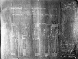
![Van[couver] sub station pelton wheel warehouse, Trout Lake](/uploads/r/null/4/d/4df0cf1a86e57b491964e9cb6bccecbe7b25a0b0fd0f2de0a202933b5a1467d2/b0238843-d0e8-47d0-9948-46578a45980f-A10339_142.jpg)
Van[couver] sub station pelton wheel warehouse, Trout Lake
Part of Major Matthews collection

Men laying power cables under Smithe Street
Part of Major Matthews collection
Photograph shows men laying two 11,000 volt cables under street. Photograph shows The corner of Smithe Street and Granville Street looking east.
![[B.C. Electric tower]](/uploads/r/null/9/0/90d20da12c50e995a559e4d2f6c82b334d71de2a5fc20b227a4d59bcd428993f/08beff16-1881-4b48-8efa-330871c8de54-A13464_142.jpg)
![[Close-up view of a portion of a hydro electric dam]](/uploads/r/null/4/c/4cfcc9054c04d687144cbafda749406c0e6db06545e2444964e2c7baf7a06f33/21625ed5-c79d-42d2-aa1c-2ab171716ceb-A13467_142.jpg)
[Close-up view of a portion of a hydro electric dam]
![[Electrical circuit box]](/uploads/r/null/3/e/3e9a411ee91c3c399acde329145cf1b8a9f5736dfc2c03248085c385833f8262/4e27a6fd-d8c4-4709-8778-0ea6e135a11c-A13334_142.jpg)
![[Hydro electric dam]](/uploads/r/null/a/3/a32d1a5ac604ff158be4ebab96eac70a8b1452e08fbad895473a04c61a75f025/8969bd58-f0d1-45d4-bd52-8cf31f238180-A13465_142.jpg)

B.C. Electric Power Plant, North Arm Burrard Inlet
Part of Hubert William Lovell fonds
Photograph was taken in the summer.
Part of City of Vancouver Archives technical and cartographic drawing collection
Map consists of a graph showing the discharge in acre feet of the Cheakamus River at Watson, 1917-1926, and the Cheakamus River near Daisy Lake, 1926-1930. Map created to accompany E.A. Cleveland's "Report on a Preliminary Investigation of the Cheakamus River Power Possibilities made for the City of Vancouver." Map has been numbered Tube 55.

Part of City of Vancouver Archives technical and cartographic drawing collection
Map is a plan of the proposed development of the Cheakamus Lake for hydroelectric power. Includes a capacity diagram of Cheakamus Lake with dam at section A-B and a plan of the proposed dam site. The map also shows elevations and types of terrain. Map created to accompany E.A. Cleveland's "Report on a Preliminary Investigation of the Cheakamus River Power Possibilities made for the City of Vancouver." A note on the map reads "Traverse from Sta. 257-50 to Sta. 371-10 by C.W. Williams 1923, Cheakamus Lake from plan by Williams (1923) except soundings as shown." Map has been numbered Tube 56.

Part of City of Vancouver Archives technical and cartographic drawing collection
Map is a plan showing the proposed hydroelectric development near McGuire and Brandywine Creek. Map was created to accompany E.A. Cleveland's "Report on a Preliminary Investigation of the Cheakamus River Power Possibilities made for the City of Vancouver." Map has been numbered Tube 57.

Part of City of Vancouver Archives technical and cartographic drawing collection
Map is a topographical plan showing a proposed hydroelectric development in the Cheakamus River area, between Garibaldi Lake and Daisy Lake, and a profile along the tunnel and pipeline route. Included on the map are Daisy Lake, Garibaldi Lake, Cheakamus River, various creeks, including Parnassus Creek and Scott Creek, bluffs, and ponds. Also indicated on the map are the locations of a pipeline, tunnel and tunnel intake, the Daisy Lake Trail and other trails, a construction shaft, proposed dam, proposed Daisy Lake Reservoir, and the power station for the Garibaldi-Daisy Lake Development. The map was created to accompany E.A. Cleveland's "Report on a Preliminary Investigation of the Cheakamus River Power Possibilities made for the City of Vancouver."

Part of Stuart Thomson fonds
![[View of] Tunnel camp on shore of Lake Buntzen](/uploads/r/null/0/d/0d0ca44891ea2357f237155492f4ca511ae1123f40281467d1bade2fb1587440/4f22d6b9-d895-48ae-b560-76f9a332a500-A32867_142.jpg)
[View of] Tunnel camp on shore of Lake Buntzen
Part of Major Matthews collection
Photograph shows the outfall of the Coquitlam-Buntzen hydraulic tunnel with a measuring weir in the foreground
Part of Major Matthews collection
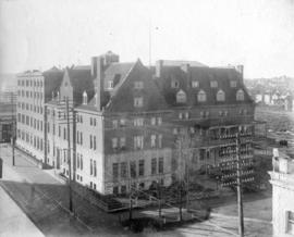
Photograph shows the first Hotel Vancouver (with extension) on the southwest corner of Granville Street and Georgia Street

Part of Major Matthews collection
![[Lower portion of concrete stack on boiler house roof of the Vancouver Steam Plant]](/uploads/r/null/f/5/f5257ae05edbe99274582d0b44bee38a31403ff65df88ad096ef6eeb045674cf/2a1ffc3c-ee45-482a-9dac-a62f9dc6212e-A08482_142.jpg)
[Lower portion of concrete stack on boiler house roof of the Vancouver Steam Plant]
Part of Major Matthews collection

Part of Major Matthews collection
![[Man standing in lane near second electric power house in Vancouver near Pender and Abbott Streets]](/uploads/r/null/a/5/a5b09d0ad281b278d1aefcb40b7421274d981942b940af2d16e37dfb024b5799/eeffd506-8655-4ec6-b448-e660a2315189-A08831_142.jpg)
[Man standing in lane near second electric power house in Vancouver near Pender and Abbott Streets]
Part of Major Matthews collection
Photograph shows building as it appears in 1931. J.S. Matthews' notes with print or negative in Archives.
![[Men constructing hydraulic tunnel for Buntzen Lake Power Plant number two]](/uploads/r/null/1/c/1ca27e0f4cabcd230fb3a04978604aa18132a3fe93fb243ad828fe149c281f70/25511899-af1b-4cf0-9a05-9f9ab85c5bd7-A08156_142.jpg)
[Men constructing hydraulic tunnel for Buntzen Lake Power Plant number two]
Part of Major Matthews collection
![[Men erecting power pole at Commercial Drive and Eleventh Avenue]](/uploads/r/null/1/1/11f1bf739a970a933dd27f65ef082e53642d725c097897cc6c964a3cfe8180a9/bc5cf794-7dc2-4536-ac80-cc2087e9a3f3-A08410_142.jpg)
[Men erecting power pole at Commercial Drive and Eleventh Avenue]
Part of Major Matthews collection
Photograph shows the Uneeda Pharmacy at 2700 Commercial Drive and houses at 2622 and 2626 Commercial Drive.
![[Men using a storage battery operated truck to haul reels of cable at the south side of False Creek]](/uploads/r/null/b/c/bc1ae10994d9b1e7ff4d6a9b215fd7e26ebeb4d93ad6f962d64ca9eab85fcbc8/93d9fb71-a74b-4272-8149-b0c3e796604f-A08601_142.jpg)
[Men using a storage battery operated truck to haul reels of cable at the south side of False Creek]
Part of Major Matthews collection
![[Men working under scaffolding in partially excavated area for Buntzen Lake Power Plant number one]](/uploads/r/null/c/1/c1fb2781358bf88bd48f20a7fbe1f2484b090ceb5a56243040fa7ab0f620627b/7aa5306f-d634-4190-bd9b-cb4b65bdfef9-A04821_142.jpg)
[Men working under scaffolding in partially excavated area for Buntzen Lake Power Plant number one]
Part of Major Matthews collection
![[Horse dragging cart out of partially excavated tunnel for Buntzen Lake Power Plant number one]](/uploads/r/null/e/6/e6b7db1f8cb2865b9c361dccd1b07ab021f2a12b5fcd2f3d60e4aaa5df2f844f/02102c14-b102-49d7-80aa-3318f0102316-A04712_142.jpg)
[Horse dragging cart out of partially excavated tunnel for Buntzen Lake Power Plant number one]
Part of Major Matthews collection
![[Interior of B.C. Electric Railway Company Limited power station]](/uploads/r/null/e/6/e6b137b3b85f6bdd30de3d35e1dd6e11da1e37da3ffd5268eec24c565dd492bd/4b8c9a56-ffae-497d-9ea3-90591a5dce39-A04730_142.jpg)
[Interior of B.C. Electric Railway Company Limited power station]
Part of Major Matthews collection
![[Interior of hydraulic tunnel for Buntzen Lake Power Plant number two]](/uploads/r/null/6/e/6e1531fc33f672a8629ea32df5798e6b22194734388b01ef46bb5971ee4da2a0/925e0988-490b-4f1e-9f45-55f46e74aa85-A08165_142.jpg)
[Interior of hydraulic tunnel for Buntzen Lake Power Plant number two]
Part of Major Matthews collection
![[Interior of power house of Buntzen Lake Power Plant number two, showing low voltage switch gallery]](/uploads/r/null/6/5/6552736c7af42252368746ff968b0130f7509443ce0af46816d29069c1e9136e/6e031352-b66b-4b7e-bfb5-11be4e838ce1-A08591_142.jpg)
[Interior of power house of Buntzen Lake Power Plant number two, showing low voltage switch gallery]
Part of Major Matthews collection
![[Newly installed power poles at the southeast corner of Hastings and Burrard Streets]](/uploads/r/null/2/1/21a14b92f356d106984357441958c60b9e3f5f02390531dc44ea911a99911d7a/576ada4a-2119-4094-820f-7973a7f08be4-A08571_142.jpg)
[Newly installed power poles at the southeast corner of Hastings and Burrard Streets]
Part of Major Matthews collection
Photograph shows power poles, planks over muddy road, and the Townley residence on the corner.
![[Newly installed power poles on Burrard Street, looking south from near Dunsmuir Street]](/uploads/r/null/c/9/c9743d1e225946d3ac73af7f2594b68f2fa18d5f7a944cdd6981a2ce1b29cca8/76bdea9a-f649-4c52-a262-f7412aa53952-A08575_142.jpg)
[Newly installed power poles on Burrard Street, looking south from near Dunsmuir Street]
Part of Major Matthews collection

Part of Major Matthews collection
![[Partially constructed Buntzen lake Power Plant number one]](/uploads/r/null/3/3/3399884ca25887202748c2fa46490d66e81f1234f05021eca5ef48b2a63830da/20d2ab59-39bd-42c5-b560-4e6d8c95d1ff-A04714_142.jpg)
[Partially constructed Buntzen lake Power Plant number one]
Part of Major Matthews collection
![[Partially constructed electrical tower]](/uploads/r/null/2/d/2dc6d49bf3be51518d959c74c0e6a34b343a1e9cb9565d55b9837f0e62f7a50f/fbd69b01-a3bd-4e8f-856a-c386541e30bf-A04747_142.jpg)
[Partially constructed electrical tower]
Part of Major Matthews collection
![[Four scenes regarding construction of Buntzen Lake power lines]](/uploads/r/null/6/0/6023501aaf77dcc646527db07ceb551a5f96b6f43e09caa395a2e721b07f32a2/dbe6c1ae-de52-4c66-9e2f-962b112188d3-A08407_142.jpg)
[Four scenes regarding construction of Buntzen Lake power lines]
Part of Major Matthews collection
Photograph negative is a copy of four photograph prints, showing: men clearing land in forest; horses and supplies next to small dock; power poles and lines; rowboat and supplies in lake near dock.