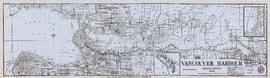
Item is a nautical chart of Burrard Inlet, including the southern portions of the North Arm of Burrard Inlet. The map shows depth soundings, harbour anchorages, headlines, beacons, buoys, bells, piers and wharves. The map also shows lot numbers, municipal boundaries and major street names of the southern portion of North Vancouver and the northern portions of Point Grey, Kitsilano, Mt. Pleasant, Fairview, Hastings Townsite, Burnaby and Port Moody from the Coquitlam municipal boundary in the east to the western boundary of the Vancouver harbour (between Point Atkinson and Point Grey) in the west. The item also includes a key map showing the location of the Vancouver Harbour in relation to northwestern Washington and Vancouver Island and an inset map showing lots surrounding the north arm of Burrard Inlet to the Inlailawatash Indian Reserve.
![[Northern view of downtown Vancouver from the World Building at 500 Beatty Street]](/uploads/r/null/9/5/95cc16c6b26e463eb28bc5ac8abec9ec6723150a2aefbca7850f264a2adff766/e88985ba-abeb-4d06-8eea-2bf10a834381-A63885_142.jpg)
![[Northern view of downtown Vancouver from World Building, 500 Beatty Street]](/uploads/r/null/9/9/997cc0ffa3d5b19d17a58c9f16a1c6f9855c9019e5f3249c78d456803ea58779/b52f219d-f015-40b1-96a6-c089ab3c8d70-A63175_142.jpg)
![[Aerial view] Coal Harbour and Deadman's Island](/uploads/r/null/4/a/4a67a24f9b0323de5c85adc302a165b41d7406154f7c77d79e1322518c819b8b/406e5e08-4114-4cc0-b260-612267ba3842-A23517_142.jpg)
![[View of Coal Harbour looking west from the foot of Broughton Street]](/uploads/r/null/9/3/938ee0983c20bbbe94d9286541d172633e29b57b47a906f60e6e43fc2d15dda0/0fd8b222-d407-4f8f-a363-f7b88343cbe3-A08809_142.jpg)

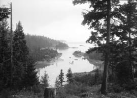
![[Two boys watching boat enter Bull Harbour]](/uploads/r/null/e/f/ef96d3d9dfb3dcfe7f79214898e35aa876eda5260f5360b9b123ca3620bf651f/62f4ecf2-2cd4-4176-9222-7d45f15e67b5-A09300_142.jpg)
![[Sailors rowing to shore from the H.M.S. "Amphion" in Vancouver harbour]](/uploads/r/null/9/b/9bfc3c89bfb227c2ed0b8630533f99722a1277d24cb1e70d34c7740bb5438220/9d00534a-5cfe-42bf-819c-c9fceb9dbf60-A07602_142.jpg)
![[View of the harbour, C.P.R. Pier 'D' and railroad yard from the roof of the Post Office]](/uploads/r/null/0/0/0017cc41004f72fbc45775cf71b997df93d9562b9877c14a78d5a30c67506a85/99ef2020-d62e-4cd3-b0b2-d2a012ec9e1f-A09878_142.jpg)
![[View of] Coal Harbour and Stanley Park from Georgia [Street]](/uploads/r/null/8/c/8c0a3b0f859c1a378c1463bc15fea75d46976a8289b6c84fcabef3840f06a3b3/490e919d-235c-4eb3-8693-3641e4b6285c-A09696_142.jpg)
![[Ships in Vancouver Harbour]](/uploads/r/null/d/6/d629566f7cb9f7a78af71c85ba3ea4a2cf7167728b91400cee1d65fd777443b3/fbfab785-d4fa-4637-8632-cf9d4b4bddca-A08055_142.jpg)


![[View of] Vancouver [harbour]](/uploads/r/null/5/3/e/53ebf8e635066e530178fc0ae20760af8e63cd463f234fe8147486ff21079622/ccc78739-a015-4e39-89ae-adbd98ea7824-CVA256-01_142.jpg)
![[H.M.S. "Dauntless" entering harbour]](/uploads/r/null/5/d/5d66f41b932a6532f37216efa5b54e117be6899abf2085829fa088445f189769/30cdf64d-7fc2-4e5b-9ce2-c2e4d02e38cd-A00136_142.jpg)
![["Lady Cecilia" docked at harbour]](/uploads/r/null/2/6/26b7ebe5c05ab80105c1df787e186e353667dcbdbecc67b47b659952e02e9dc6/8b9f7e20-3108-4850-9ec2-d1e854bd5c1c-A01748_142.jpg)
![["Lady Cecilia" docked at harbour]](/uploads/r/null/1/2/12849060169b219d0d918c4fa6a5bc5ee3fa04eb4ffc689f2afacc52cd3d40d7/8cda520d-0c78-4b29-9d3c-a1d0564d1c4a-A01756_142.jpg)
![[Bowen Lodge viewed from harbour]](/uploads/r/null/f/4/f4870e098d1b1bb9ef2544df5c113bed17824caf3a0ccb4736743bec67d65a04/3c930c6c-3285-43d7-95ac-67ed6c69d07e-A16128_142.jpg)
![[Coastal steamship] "Prince George" aground at 1st Narrows](/uploads/r/null/7/2/72c3f456be5f97334f1438b1e5d24a33f35c2e770793ebc9cd9f0f85ef9c3e41/323ecce2-b557-45f4-84eb-2d110852168f-A16207_142.jpg)
![Vancouver Rowing Club [4 man crew on Coal Harbour, arena in background]](/uploads/r/null/9/3/935840dc4b6c8c35b8b892893f6258a14f1cf901a02acf4940f39acfa1849aaa/04258287-c4b5-454c-b01b-694fac748a20-A00426_142.jpg)
![Vancouver Rowing Club [8 man crew on Coal Harbour with Stanley Park causeway in background]](/uploads/r/null/0/b/0b7cbc84696c537aae2ba9f958eb8f0d59b6af742fd832bb028e3e708458a461/e95d446c-68ec-444d-ae9a-95215c3787db-A00424_142.jpg)

![Vancouver Rowing Club regatta [in Coal Harbour]](/uploads/r/null/a/e/aea8be199ec45ccdd094f8522d641eeb65f1727a99257a6fd819f5fc1a238747/07b65312-a17f-4a09-a8ad-6f5d06c86828-A00750_142.jpg)


![Japanese team leaving on "Manila Maru" [in Burrard Inlet harbour]](/uploads/r/null/1/c/1c952bb5ee2e74d093ce70461d7b5fe09a224b3c2216d973e51164484492b16b/f2880abc-a93b-46fd-8266-111ed222dbeb-A01171_142.jpg)

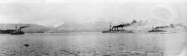
![Australian Cruiser New Zealand [HMS New Zealand]](/uploads/r/null/4/7/47f1ff409d6ea3b747698613fdd117f202fdf19eadad50ca1a784f48b12bf276/8ea6ae46-954d-4da1-9a45-b9af0017adba-A49469_142.jpg)
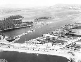
![[Aerial view of Vancouver Harbour looking east from Lost Lagoon]](/uploads/r/null/a/7/a7c598133f7f2c78a6bb65602262bc193ceb787389db5cd31ded3868025265ca/72eb674f-7c20-4ecc-a618-3a1e88e660c8-A62798_142.jpg)
