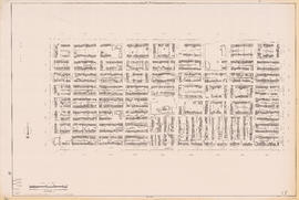
Sheet 11C [Victoria Drive to 45th Avenue to Knight Street to 53rd Avenue]
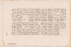
Sheet 12B [Vivian Street to 53rd Avenue to Duff Street to 61st Avenue]
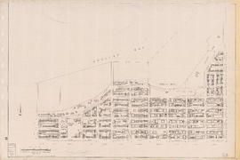
Sheet 12C [Victoria Drive to 61st Avenue to Knight Street to Fraser River]
Sheet 15D [Clark Drive to Grandview Highway to Fraser Street to Broadway]
Sheet 16A [Fraser Street to Broadway to Main Street to 16th Avenue]
Sheet 16B [Clark Drive to Broadway to Fraser Street to 16th Avenue]
Sheet 17C [Fraser Street to 33rd Avenue to Main Street to 41st Avenue]
Sheet 19A [Fraser Street to 57th Avenue to Main Street to SE Marine Drive]
Sheet 19C [Fraser Street to SE Marine Drive to Main Street to Fraser River]
Sheet 19D [Crompton Street to SE Marine Drive to Fraser Street to Fraser River]
Sheet 20B [Burrard Street to Burrard Inlet to Cardero Street to Georgia Street]
Sheet 20E [Burrard Street to Davie Street to Cardero Street to False Creek]
Sheet 21D [Station Street to Georgia Viaduct to Connaught Bridge to False Creek]
Sheet 22A [False Creek to Burrard Bridge to Fir Street to Broadway]
Sheet 24B [Main Street to King Edward Avenue to Cambie Street to 31st Avenue]
Sheet 25A [Cambie Street to 41st Avenue to Oak Street to 49th Avenue]
Sheet 25C [Cambie Street to 49th Avenue to Oak Street to 57th Avenue]
Sheet 26C [Yukon Street to 64th Avenue to Fremlin Street to Kent Avenue]
Sheet 26D [Main Street to SW Marine Drive to Yukon Street to Fraser River]
Sheet 28B [Oak Street to Broadway to Granville Street to 16th Avenue]
Sheet 29C [Granville Street to 33rd Avenue to maple Street to 41st Avenue]
Sheet 30A [Granville Street to 41st Avenue to Maple Street to 49th Avenue]
Sheet 31A [Granville Street to 57th Avenue to Arbutus Street to 64th Avenue]
Sheet 31B [Laurel/Fremlin Streets to 57th Avenue to Granville Street to 64th Avenue]
Sheet 33A [Stephens Street to English Bay to Blenehim Street to 1st Avenue]
Sheet 33B [Arbutus Street to English Bay to Stephens Street to 1st Avenue]
Sheet 35A [Trafalgar Street to King Edward Avenue to Blenheim Street to 33rd Avenue]
Sheet 36A [Trafalgar Street to 41st Avenue to Blenheim Street to 49th Avenue]
Sheet 36B [Maple Street to 41st Avenue to Trafalgar Street to 49th Avenue]
Sheet 39C [Wallace Street to 16th Avenue to Discovery Street to King Edward Avenue]
Sheet 43B [Discovery Street to English Bay to Blanca Street to 2nd Avenue]
Preliminary report on civic centre
Port of Vancouver water-borne imports
Map of City of Vancouver showing schools, parks, community centres, libraries, health units
Vancouver parks map
City of Vancouver : land use 1984
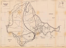
Stanley Park
Existing service stations, retail shopping centres and commercial zoning : a basis for regulating location of service stations
Zoning map : City of Vancouver, British Columbia
City of Vancouver, B.C. area map : Maple Street to Heatley Avenue and Burrard Inlet to 6th Avenue
City of Vancouver, B.C. area map : Granville Street to Inverness Street and 37th Avenue to 57th Avenue
Vancouver Parks and Recreation : map and guide
Eating for a healthy baby
Feeding your baby the first year
Sectional map of Vancouver showing streets, block and lot outlines, and building perimeters : Map 4 : Chilco Street to Burrard Street and Coal Harbour to Robson Street
Sectional map of Vancouver showing streets, block and lot outlines, and building perimeters : Map 12 : Nanaimo Street to Cassiar Street and McGill Street/Wall Street to Pender Street
Sectional map of Vancouver showing streets, block and lot outlines, and building perimeters : Map 15 : Rupert Street to Boundary Road and Pender Street to Kitchener Street
Sectional map of Vancouver showing streets, block and lot outlines, and building perimeters : Map 17 : Nanaimo Street to Rupert Street and Pender Street to Charles Street
Sectional map of Vancouver showing streets, block and lot outlines, and building perimeters : Map 18 : Nanaimo Street to Rupert Street and Charles Street to 5th Avenue
Sectional map of Vancouver showing streets, block and lot outlines, and building perimeters : Map 23 : Balaclava Street to Maple Street and English Bay to 3rd Avenue
![Sheet 11C [Victoria Drive to 45th Avenue to Knight Street to 53rd Avenue]](/uploads/r/null/1/d/b/1db11c78e6cbe071c16384954f6cd1c4c7422e511137dfb0d9e475b02429a91e/db8e4f44-94b1-4019-bde7-af2a3bf524f7-LEG1153_142.jpg)
![Sheet 12B [Vivian Street to 53rd Avenue to Duff Street to 61st Avenue]](/uploads/r/null/e/3/c/e3c8b6efb1d27795c9f95fe0f4f635f96177ec6611aee5c04eb73461e3e81764/b44ecc2f-977b-4819-b58e-558f10cb6378-LEG1153_142.jpg)
![Sheet 12C [Victoria Drive to 61st Avenue to Knight Street to Fraser River]](/uploads/r/null/a/a/4/aa437dca1bb56cbf7a607a6aedce32ae3371be7f3cbfb2e70b74c5e77475af88/6b33c2e7-54fb-44b5-9041-deaad0006465-LEG1153_142.jpg)
![Sheet 15D [Clark Drive to Grandview Highway to Fraser Street to Broadway]](/uploads/r/null/d/0/e/d0e220b834f59ce819f81267f1e4cc2724f031820858ed76bb176c0f78859d08/7e5618ca-ce76-4c90-9c1c-9042a16f0b07-LEG1153_142.jpg)
![Sheet 16A [Fraser Street to Broadway to Main Street to 16th Avenue]](/uploads/r/null/0/c/7/0c74c17cd5eb576019a803e39c6192464bf755b44c7bf8c2af8bc91a4f0c29b2/3b3792a9-4ef2-45a6-a9a6-e8470ab8bc87-LEG1153_142.jpg)
![Sheet 16B [Clark Drive to Broadway to Fraser Street to 16th Avenue]](/uploads/r/null/f/6/4/f64fe8a94788508f9a26125039fd52a10d68c57a6a7955d76b2c90b54cd5bee5/9f5d808d-0e32-404e-9c2d-0cf2ffb68584-LEG1153_142.jpg)
![Sheet 17C [Fraser Street to 33rd Avenue to Main Street to 41st Avenue]](/uploads/r/null/5/0/f/50f7c2c32c74cf702ebabbc3345a81811979b51b3074175b7500158f27725381/b5798db5-5cd1-40b1-ba70-17af70186dc8-LEG1153_142.jpg)
![Sheet 19A [Fraser Street to 57th Avenue to Main Street to SE Marine Drive]](/uploads/r/null/2/b/5/2b5c2f174f2356fca8e2a0d86b4df5171d325361bd9ec032e6e326729ef84c11/88e414e3-2235-4985-a9d8-68ade9300ff3-LEG1153_142.jpg)
![Sheet 19C [Fraser Street to SE Marine Drive to Main Street to Fraser River]](/uploads/r/null/f/b/f/fbf3a2bb81c752fc0c5c088ad4b3cec34da9b34f167d22cbe1a942b58136072a/db6db2f9-ab33-4783-aecf-bdcafb0b2647-LEG1153_142.jpg)
![Sheet 19D [Crompton Street to SE Marine Drive to Fraser Street to Fraser River]](/uploads/r/null/b/b/d/bbd20e33657463fa11e84c72e9c22e61a326c74b3e345ca538a418df34a8e50d/ddb0302d-83c7-4fac-9e2f-42d92247806b-LEG1153_142.jpg)
![Sheet 20B [Burrard Street to Burrard Inlet to Cardero Street to Georgia Street]](/uploads/r/null/2/d/7/2d75e4f8be37129a74a2b029a37894a5c9236512c1cf1e87f396ab643322d50a/6599a0ed-8fbc-49e5-a54c-be3ac20f7ff9-LEG1153_142.jpg)
![Sheet 20E [Burrard Street to Davie Street to Cardero Street to False Creek]](/uploads/r/null/2/8/8/28803b69ed37ea5295c834f1dc116b0d3f55d7906623919d9aec8a599b694eeb/617839ac-0ec0-488b-be9f-da51556150ce-LEG1153_142.jpg)
![Sheet 21D [Station Street to Georgia Viaduct to Connaught Bridge to False Creek]](/uploads/r/null/1/c/c/1cce6e5de2ecb3689ce514a49bb625c3d1bacd82e33995a5836567dfbea0527a/e827967d-d48c-4cb2-b0c5-e96d77cc421f-LEG1153_142.jpg)
![Sheet 22A [False Creek to Burrard Bridge to Fir Street to Broadway]](/uploads/r/null/2/9/9/299875c18b9ea151bb9a574e273ac6a8ab0828369c0c8d7d5bdf172ac745641f/7dfddd59-1e03-46a4-9ede-f23bbc55e8fb-LEG1153_142.jpg)
![Sheet 24B [Main Street to King Edward Avenue to Cambie Street to 31st Avenue]](/uploads/r/null/6/b/e/6be171c12870a10680c5d4e5ffc0c28a4e5f2599b7e9cf410853373d275dc79b/5babbd98-8853-4663-915a-6ab0735179dd-LEG1153_142.jpg)
![Sheet 25A [Cambie Street to 41st Avenue to Oak Street to 49th Avenue]](/uploads/r/null/2/a/c/2ac3063a0c3c88b108ed5cd490bd016ccd27b83de9c016f7b2095d92a350254f/8ded00ee-e2c6-49d8-979b-28df2df7864c-LEG1153_142.jpg)
![Sheet 25C [Cambie Street to 49th Avenue to Oak Street to 57th Avenue]](/uploads/r/null/3/9/c/39cbabc22fef55ee96797487731e97bca5a2ee9b8adbdab28d71d16a55e6459b/497c7d8d-f437-4339-b631-481933ef51c5-LEG1153_142.jpg)
![Sheet 26C [Yukon Street to 64th Avenue to Fremlin Street to Kent Avenue]](/uploads/r/null/1/e/3/1e3c0d49d5b6bd49c571c7dddc74fbd87d680726a69d28b8eaa3e23de2bd8956/d4884c98-7d8e-403f-a192-4726d342c5dc-LEG1153_142.jpg)
![Sheet 26D [Main Street to SW Marine Drive to Yukon Street to Fraser River]](/uploads/r/null/3/1/6/3161bed16af9a222ebc8c176831f06d57cc134e38fc48d0275899ad1007fcdd6/ad857108-61f7-4a73-a1cd-ade56977c6af-LEG1153_142.jpg)
![Sheet 28B [Oak Street to Broadway to Granville Street to 16th Avenue]](/uploads/r/null/e/3/9/e39c7f8c28163119556e70691eaf85fcdf329eadaca535b09b09fdad0f446575/bc31e72d-4dd5-49db-8645-2a92c42285bb-LEG1153_142.jpg)
![Sheet 29C [Granville Street to 33rd Avenue to maple Street to 41st Avenue]](/uploads/r/null/5/9/6/59630ff85c6803e8299a6bea855daca96289d017d436c4d6c289fe874c13a41a/9d616eed-5783-4388-a5f6-6eea4ecd4ce6-LEG1153_142.jpg)
![Sheet 30A [Granville Street to 41st Avenue to Maple Street to 49th Avenue]](/uploads/r/null/d/7/2/d72ce36bbecdb5e5a7a132573fa9297e36714fae8be8866729ea7693a072210e/6e00c84e-6810-4d67-9923-fa850decae8f-LEG1153_142.jpg)
![Sheet 31A [Granville Street to 57th Avenue to Arbutus Street to 64th Avenue]](/uploads/r/null/9/1/8/9184c8698fca3e24151617df2798ae607719079ff33f3a87f663491cd817816d/2abef7f3-0cb9-4ddd-83da-29c5bd925126-LEG1153_142.jpg)
![Sheet 31B [Laurel/Fremlin Streets to 57th Avenue to Granville Street to 64th Avenue]](/uploads/r/null/0/f/b/0fba99a8fde4007d2bdfe0aec799f50b122b42e9026890e8fc2d1c8943e80b52/f3c96070-7b31-49e5-992a-596008dc0f20-LEG1153_142.jpg)
![Sheet 33A [Stephens Street to English Bay to Blenehim Street to 1st Avenue]](/uploads/r/null/a/f/e/afe1579741abced0aad5df778dfd35c9f63988bccee0fa7a3b9da9a15f793635/87232a2f-22b5-44cb-ad35-8c52fc23f5a9-LEG1153_142.jpg)
![Sheet 33B [Arbutus Street to English Bay to Stephens Street to 1st Avenue]](/uploads/r/null/8/f/c/8fc713dcb77b096222ee8638c5b1e194f635c9af7b1f7f1d17abf1b019cdff75/7058ad67-b7a0-4940-9742-d752033ff385-LEG1153_142.jpg)
![Sheet 35A [Trafalgar Street to King Edward Avenue to Blenheim Street to 33rd Avenue]](/uploads/r/null/6/4/8/648be52a546b43201063ee32aea015a66237c5ebd207aa6f1c773f9ed5705860/f195e23a-7e01-4b75-9b68-050ee5d330f4-LEG1153_142.jpg)
![Sheet 36A [Trafalgar Street to 41st Avenue to Blenheim Street to 49th Avenue]](/uploads/r/null/2/8/4/28460f6a324d3a76d6e4b6164988efd9eae41a90614f984a6108a03436add80d/a5c058b4-8ee2-4bad-b10e-7b990bc2e566-LEG1153_142.jpg)
![Sheet 36B [Maple Street to 41st Avenue to Trafalgar Street to 49th Avenue]](/uploads/r/null/a/4/0/a40c683a4e05e13a0b2788be31d5bd9e052323e28a1c760c2c1370625278ab20/7377513a-5067-46ca-bc51-fb94fc7fdc29-LEG1153_142.jpg)
![Sheet 39C [Wallace Street to 16th Avenue to Discovery Street to King Edward Avenue]](/uploads/r/null/2/5/c/25c5aa22e403558f96fbd40e3ae0947be0ace24e232e953b87a2fb754b3fb1a3/ff315df3-3abc-48e3-b95c-305139a29e88-LEG1153_142.jpg)
![Sheet 43B [Discovery Street to English Bay to Blanca Street to 2nd Avenue]](/uploads/r/null/2/1/0/21007a691605ce3411c27c74a7e68e1ecc145d09c86feadc96ecb9b090f3c96e/bff71469-8c56-4157-b106-946d78ab28bd-LEG1153_142.jpg)