![[Bowen Island scene from boat trip March 7, 1953]](/uploads/r/null/0/4/049ec7fb246470ca4f590c3cbfa6e46a8795455a71d2c3c21afe2426ee5c3008/bf741e19-38f3-48c8-80eb-e6b877c8cfb7-A71162_142.jpg)
[Bowen Island scene from boat trip March 7, 1953]
![[Bowen Island scene from boat trip March 7, 1953]](/uploads/r/null/6/4/642daae55d9a4deb012075271cc6342dc5beb5290a03022962b130b652fd1c33/808f7497-2229-4011-a4b6-566e08faee31-A71163_142.jpg)
[Bowen Island scene from boat trip March 7, 1953]
![[Bowen Island scene from boat trip March 7, 1953]](/uploads/r/null/4/9/49e0f0a5f81b9079ab8822af953910001c3e1db40c3960984a20d6f90f282d9f/9e2f8476-8b95-4894-869c-487fafcea128-A71164_142.jpg)
[Bowen Island scene from boat trip March 7, 1953]
![[Bowen Island scene from boat trip March 7, 1953]](/uploads/r/null/a/1/a138decd40903e5d655425ad45494e28e47c3eae26146c3b8e7e8edf6c007d83/096a7bb7-8c87-4e4e-a196-e590459d93c1-A71165_142.jpg)
[Bowen Island scene from boat trip March 7, 1953]
![[Bowen Island scene from boat trip March 7, 1953]](/uploads/r/null/e/7/e767fea657f613209a355fc9ab222383576e2fbfea990de99680c9d494c9ff4e/d5ad6dcf-3ac6-4591-9b2f-1d61c30e6f5a-A71166_142.jpg)
[Bowen Island scene from boat trip March 7, 1953]
![[Bowen Island scene from boat trip March 7, 1953]](/uploads/r/null/e/3/e3552b92f1c9d6bc4f542a13dbfce0fbfd7bf8cb8838be4df427074c0636164c/8fdd6be5-d7e7-4981-9fa9-d271ecf2d991-A71167_142.jpg)
[Bowen Island scene from boat trip March 7, 1953]
![[Bowen Island scene from boat trip March 7, 1953]](/uploads/r/null/f/9/f9f5ed0e50ce1bfe1653e57453c729dddcfcc28c2284e9aaa11f83eff2b677b9/1aab4fae-9973-42ea-b3f1-14e2d3570cd8-A71168_142.jpg)
[Bowen Island scene from boat trip March 7, 1953]
![[Bowen Island scene from boat trip March 7, 1953]](/uploads/r/null/5/b/5b6159bbec2a24c9d7857a58ae2a1482a7b3ce1f1c31c8ca188850b6c698e190/73bb5dd7-b637-401f-a076-22324980a483-A71169_142.jpg)
[Bowen Island scene from boat trip March 7, 1953]
![[M.H. Dobie]](/uploads/r/null/6/6/66b510c9b57ffe63a79e60e469e2864c14d21c74942901d401b2ecc9f53381c2/2b7de2e7-300e-4365-a9e4-4e392da4c3f3-A71177_142.jpg)
[M.H. Dobie]
![[Clay model for bronze bust of Emily Matthews]](/uploads/r/null/c/e/ce2a059b56f6f5e19f7a08efef7b9d61425ab2adea104e969c0d46088c1d2bb9/a326c064-3f39-4f31-bebc-59e0edd7d62a-A71195_142.jpg)
[Clay model for bronze bust of Emily Matthews]
![[Clay model for bronze bust of Emily Matthews]](/uploads/r/null/a/c/ac9e099394837d5297b1095acc2ec9840c42e189c5851ce76e0ff68883696235/a6aab21b-edac-457b-b735-8ccf12221979-A71196_142.jpg)
[Clay model for bronze bust of Emily Matthews]
![[Clay model for bronze bust of Emily Matthews]](/uploads/r/null/e/5/e5be87aa094e7b78fde221bce2cff5c312ee183a07fca6052942cd4a7523a304/4da8cb13-cca9-49a2-ad0a-0bff95608871-A71197_142.jpg)
[Clay model for bronze bust of Emily Matthews]
![[Attendees of ceremony for Captain George Vancouver's grave look on as Earle Westwood speaks]](/uploads/r/null/c/5/c5438ac19aaa85e5df80881a3f0a15a5992ff23bc2c3ca1a99b76a9479ad9571/718acc56-2ea7-4de5-8479-40db1257db3d-A71199_142.jpg)
[Attendees of ceremony for Captain George Vancouver's grave look on as Earle Westwood speaks]
![[Attendees of ceremony and Captain George Vancouver's grave]](/uploads/r/null/f/d/fd0a70a378c80aaf933f673bc71d081fed35de37f70e80c24c0808f3a9c47e89/a04a56b2-22af-478d-82b4-06c24ec8f1e2-A71200_142.jpg)
[Attendees of ceremony and Captain George Vancouver's grave]
![[Miss Emily E. Edwardes (Mrs. Emily Matthews) holding Sam Kenworthy]](/uploads/r/null/d/b/db3d24249c6e11bf91bd20fb5dae6c980f9cf6e95bdbe91af78984d1c75007f4/51f8478b-fdb7-49f5-8983-f43c6dc05f74-A35268_142.jpg)
[Miss Emily E. Edwardes (Mrs. Emily Matthews) holding Sam Kenworthy]
![[Mrs. J.S. Matthews]](/uploads/r/null/f/3/f363ee6c0dfc24f7023c94367daf3937756730861131cea7ebe35d0f367c8910/4d382674-55b7-40bd-94d1-8adbb3bc64e0-A35187_142.jpg)
[Mrs. J.S. Matthews]

Foundation plan and ground floor plan
![Foundation plan and ground floor plan [annotated]](/uploads/r/null/0/2/3/023a35190c3e23e9b9ec7030bc190322c30611808fbf7259d9327c94b8a1bea9/2f34bffc-75e1-48fe-8061-d06c2b1bd819-LEG1801_142.jpg)
Foundation plan and ground floor plan [annotated]

Mezzanine and second floor plan

Sketch of roads

Sketch of lots south-west of Gibson's Landing

First draft of lot boundaries

Lots with owner names and dates
![Gibson's Landing settlement early features [rough draft]](/uploads/r/null/3/c/d/3cda6f3ed9b7fc36a9d0e314f3396291703d07a19e1d73947b496bdea7be9b3b/484a079f-90f4-4df1-a6e6-6055d83df45b-LEG1801_142.jpg)
Gibson's Landing settlement early features [rough draft]

False Creek

Land registry order Block B & I, D.L. 182 Plan No. 186
![Plan of westerly portion of subdivisions B & I [District] Lot 182 Group 1 New Westminster Dis...](/uploads/r/null/d/8/6/d86cf594a72e590d8796d28c3f641e40d4778d1f87cdae5fff529f7f640dee79/421a486d-902c-45ca-bbbd-0ce2fc9c00e5-LEG1801_142.jpg)
Plan of westerly portion of subdivisions B & I [District] Lot 182 Group 1 New Westminster District

Registered subdivisions of Block 148, D.L. 264A Group 1 New Westminster District
![Plan for showing boundaries of Lots 13, 14 of Block 23 [D.L. 182?]](/uploads/r/null/0/4/d/04da9293a2b37640b4b1582065e79e8df42500a18c6dc1976ffe829e141f53c7/191eceb6-25c5-4745-9582-13484cbeb00b-LEG1801_142.jpg)
Plan for showing boundaries of Lots 13, 14 of Block 23 [D.L. 182?]
![Plan of subdivision K and part of subdivision A and H [District] Lot 182 Group 1 New Westminster ...](/uploads/r/null/8/f/f/8ff27d1aa4a9ba03458811764e5d3a18a7196361d08fab462c7cc9912da2129c/7bcf175a-9558-4f32-958f-a765b693d1c3-LEG1801_142.jpg)
Plan of subdivision K and part of subdivision A and H [District] Lot 182 Group 1 New Westminster District

Front cover (exterior)

Front cover (interior)

Two hours before maximum ebb at First Narrows

One hour before maximum ebb at First Narrows

Maximum ebb at First Narrows

One hour after maximum ebb at First Narrows

Two hours after maximum ebb at First Narrows

Three hours after maximum ebb at First Narrows

Two hours before maximum flood at First Narrows

One hour before maximum flood at First Narrows

Maximum flood at First Narrows

One hour after maximum flood at First Narrows

Two hours after maximum flood at First Narrows
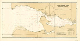
Three hours after maximum flood at First Narrows

Back cover (interior)

Front elevation

Ground floor plan

Front elevation and second floor plan

Foreshore survey D.L. 185

Foreshore D.L. 181 westward