
Vancouver from Hastings Street
- AM54-S4-: Van Sc P2
- Item
- [ca. 1891]
Part of Major Matthews collection
Photograph shows a northeast view from Richards Street
9835 results with digital objects Show results with digital objects
Vancouver from Hastings Street
Part of Major Matthews collection
Photograph shows a northeast view from Richards Street
![[Looking northwest from the Hotel Vancouver on the corner of Granville Street and Georgia Street]](/uploads/r/null/9/b/9bc7b31467f04c66440a23b6ad44d02934b3756b8e0dda107f815f6656f91e37/d52fede5-4254-4096-aaba-a44a1b3957c5-A43212_142.jpg)
[Looking northwest from the Hotel Vancouver on the corner of Granville Street and Georgia Street]
Part of Major Matthews collection
Photograph shows a view of the west side of the 600 Block Howe Street and beyond

Vancouver, B.C. from Hotel Vancouver
Part of Major Matthews collection
Photograph shows a view looking east from Georgia Street towards the 600 Block Seymour Street
![[Looking east from Carroll Street near the Georgia Viaduct]](/uploads/r/null/0/1/0198bb73987244240ed41a21da43f52e715080a9150510fb723dc0066626ebf0/179b2de9-bf97-4bb5-ab74-4463cb1bbf09-A43300_142.jpg)
[Looking east from Carroll Street near the Georgia Viaduct]
Part of Major Matthews collection
Photograph shows Marshall-Wells B.C. Limited, the Woodward's beacon, the Sun Tower and the second and third Hotel Vancouver
![[View looking east from Main Street and Pender Street]](/uploads/r/null/8/0/809cf6a26840094bf6d8fe3ddd67086496a879a0bb94d26685982dda7e6f42a7/0bafdc9e-9e34-4fc8-9e04-8b7bcfd96944-A43299_142.jpg)
[View looking east from Main Street and Pender Street]
Part of Major Matthews collection
Oblique view
![[View looking north from City Hall]](/uploads/r/null/3/7/3719510f814648ae0b2e7b0ce76d43a412104e50f0c080895fe1c0a328907de6/96db8e82-b144-4bfe-9fe2-c74239a3f26b-A43298_142.jpg)
[View looking north from City Hall]
Part of Major Matthews collection
Photograph shows the Fraser Valley Milk Producers Association (Dairyland) building, the Cambie Bridge, False Creek, Downtown anf The Lions in the background
View from the Roof Garden, Hotel Vancouver, Vancouver, B.C.
Part of Major Matthews collection
Photograph shows a view looking north including the Marine Building
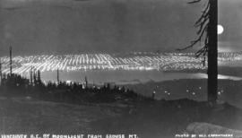
Vancouver, B.C. by Moonlight from Grouse Mountain
Part of Major Matthews collection
![Vancouver, B.C. [from the air looking east from Lost Lagoon]](/uploads/r/null/5/1/5127fcacb95395f95ba7c0f104a40a408b7f3d76e10c9881ebcc71cfc1a7c5de/ee54b68d-1f24-417f-b491-0956e3d4522f-A42965_142.jpg)
Vancouver, B.C. [from the air looking east from Lost Lagoon]
Part of Major Matthews collection
Oblique view showing the Denman Arena, the Horse Show building, the Coal Harbour waterfront and the West End

Part of Major Matthews collection
Photograph shows a northern view of Vancouver from Queen Elizabeth Park

Part of Major Matthews collection
Photograph shows a view looking north from the corner of Westminster Avenue (Main Street) and 7th Avenue including the Westminster Avenue Trestle Bridge and False Creek in the background
![[Northern view of the 600 Block between Howe Street and Granville Street from the Hotel Vancouver]](/uploads/r/null/f/f/ff1346527da8addf4e4ac2a5452cecc5e7730d9cf121286a4cc5d9efa6377496/f84fd027-2319-449c-8647-d7784d865359-A43293_142.jpg)
[Northern view of the 600 Block between Howe Street and Granville Street from the Hotel Vancouver]
Part of Major Matthews collection
Photograph shows the Van Horne Block, the Japanese Consulate, the Alhambra Theatre and the Bank of Montreal
![[View of Mount Pleasant looking northeast from City Hall]](/uploads/r/null/0/0/00f3be8cb9dc06c9f844f78cf67bf5b62a3d09109caccd699ac683b4f47a90e4/a8fc3c83-fbc0-4050-8f98-ae95939608f6-A43292_142.jpg)
[View of Mount Pleasant looking northeast from City Hall]
Part of Major Matthews collection
![[View of Fairview looking west from City Hall]](/uploads/r/null/d/8/d87892f743f488ae9a2f5003bc53c8a5f283417a8d4193ff9f894feec2d06564/ee474602-8f4a-4cf4-9f70-7a60fb4e7bad-A43291_142.jpg)
[View of Fairview looking west from City Hall]
Part of Major Matthews collection
Photograph shows False Creek, the Burrard Bridge and Yaletown in the background
![[Panoramic view looking north from the Hotel Vancouver]](/uploads/r/null/d/0/3/d032ae1a08ec1b68763941336f6a07708bf678235ae8cdf506cbbdc3fb10451d/98ea51ff-abce-48a9-9401-16834b8ba6a4-VanScP143_142.jpg)
[Panoramic view looking north from the Hotel Vancouver]
Part of Major Matthews collection
Photographs show the west side of the 600 Block of Howe Street, Manor House, Deadman's Island, the 600 Block of Granville Street, the Van Horne Block, the Hudson Bay Company store, the Homer Street Methodist Church, the tower of Holy Rosary Cathedral and other buildings and houses

Part of Major Matthews collection
Oblique view showing Brockton Point and the Marine Building and the second and third Hotel Vancouvers in the background
![[View looking north from City Hall]](/uploads/r/null/7/a/7a5cefae760823892740b59c0b38bbc5bd3272ce46ad037b620199ee82e0416c/eef32f5c-231c-4970-8973-c3324d2a90d1-A43290_142.jpg)
[View looking north from City Hall]
Part of Major Matthews collection
Photograph shows the Fraser Valley Milk Producers Association (Dairyland) building, the Cambie Bridge, False Creek and Downtown in the background
![[View of the east side of the 600 Block Granville Street]](/uploads/r/null/7/0/701ea9e113109a11728915c53b9320ccd9c10a7cb13f66dcbd9f863af09eabb4/358794d9-e088-422e-ad90-962c67e5f1a9-A43289_142.jpg)
[View of the east side of the 600 Block Granville Street]
Part of Major Matthews collection
![[View of the west side of the 600 Block Howe Street from the Hotel Vancouver]](/uploads/r/null/c/0/c02f6bb88e2050d63590f8a5785d169342306ab410ca9c27e710474bfc041360/b4848079-0ce9-44ce-b44f-cb935dea0e54-A43288_142.jpg)
[View of the west side of the 600 Block Howe Street from the Hotel Vancouver]
Part of Major Matthews collection
![[Aerial view showing the northwestern section of Downtown]](/uploads/r/null/d/a/da84098b0ef036990e34132f726d1491bbbb1fc247cc76fc6659886372017fdc/a8601693-c900-4d47-a380-9979b203400b-A43287_142.jpg)
[Aerial view showing the northwestern section of Downtown]
Part of Major Matthews collection
Oblique view showing Deadman's Island, Coal Harbour, Brockton Point, the First Narrows, the Lion's Gate Bridge and North and West Vancouver in the background
![[Aerial view looking northwest over Downtown]](/uploads/r/null/b/7/b7ca69254d2cbe14ffd3cb21ed6f3b1fed68dde7a4a5843876f8c173674d9d01/a1129a0c-5269-4488-9376-66246af93f6d-A43286_142.jpg)
[Aerial view looking northwest over Downtown]
Part of Major Matthews collection
Oblique view showing the Cambie Street Bridge, the Georgia Viaduct, Pier B-C, Stanley Park, Coal Harbour, the Lion's Gate Bridge and West Vancouver in the background
![[Northern view of False Creek Flats from Mount Pleasant]](/uploads/r/null/4/c/4c21145a751d4755607fbd86dd1a02b6124e2a5073f3f6f876110310c5fabf21/0e75cede-a8b6-49ce-9be7-a64b95a7e3dd-A43285_142.jpg)
[Northern view of False Creek Flats from Mount Pleasant]
Part of Major Matthews collection
![[Northern view from Downtown towards North Vancouver]](/uploads/r/null/c/4/c4e11a8eb3deeb229ed4c8539e7289a1e13542dc6ac3473728390d68502f859d/b78c1952-8208-46b9-9aab-747d52e91072-A43284_142.jpg)
[Northern view from Downtown towards North Vancouver]
Part of Major Matthews collection
Photograph shows Brockton Point
![[View of Deadman's Island after being clear-cut of trees]](/uploads/r/null/0/d/0d52bc123aeaf44551a219dde291611efbf6a9f8b49e80e436cdbf33322e2eec/184b970b-6838-4854-bb67-7cd007564196-A43283_142.jpg)
[View of Deadman's Island after being clear-cut of trees]
Part of Major Matthews collection

Georgia Street Vancouver, B.C.
Part of Major Matthews collection
Oblique view looking east along Georgia Street from Broughton Street showing the Felix Apartments on Jervis Street, The Hotel Vancouver, Christ Church Cathedral and other buldings
![[Eastern view from the tower of King Edward High School on 12th Avenue and Oak Street]](/uploads/r/null/6/4/64f31f7061366669863378ac44af64ca28593268ca45c2a6b55a3de95c9e9598/a20f13db-f76e-40b2-b4a2-4ebf751752c7-A47182_142.jpg)
[Eastern view from the tower of King Edward High School on 12th Avenue and Oak Street]
Part of Major Matthews collection
Photograph shows the eastern part of Fairview, with the first Cambie Street bridge in the foreground and the Main Street trestle in the background.
![[Northern view from the tower of King Edward High School on 12th Avenue and Oak Street]](/uploads/r/null/c/6/c6a2098e8be2096dd153388c7cc69b6590ff14fcd374b1ac1f691ebf1dc50441/abe0536e-5915-41aa-9d09-95d6c9e97be5-A47183_142.jpg)
[Northern view from the tower of King Edward High School on 12th Avenue and Oak Street]
Part of Major Matthews collection
Photograph shows part of Fairview and False Creek, the Connaught Bridge and Yaletown in the background
![[Northern view of Fairview from the tower of King Edward High School on 12th Avenue and Oak Street]](/uploads/r/null/b/c/bc4f34ad9aa5a5bc18dec6ca7832786f8b77217c3729cf25944c96705a9e416a/32c6ae21-a7bc-452c-89be-9f78d8c1067f-A43282_142.jpg)
[Northern view of Fairview from the tower of King Edward High School on 12th Avenue and Oak Street]
Part of Major Matthews collection
Photograph shows False Creek and Yaletown, with the first Granville Street Bridge and Burrard railway trestle in the background.
![[Western view of Fairview from the tower of King Edward High School on 12th Avenue and Oak Street]](/uploads/r/null/5/7/57f78634c36cdc44896b928e95b888dc11481e391bcf511d52692a2ee6953e09/d4c21e48-ce87-44ed-8181-22199bd4fa93-A43281_142.jpg)
[Western view of Fairview from the tower of King Edward High School on 12th Avenue and Oak Street]
Part of Major Matthews collection
Photograph shows the C.P.R. Kitsilano Trestle and the Granville Street Bridges
![[Northern view of Vancouver from Queen Elizabeth Park]](/uploads/r/null/7/4/74be239ca41d3c8e917bb89bcc04a218371dda9cbb806fabc2eac55afc5fee1e/934890e8-cf9f-47a4-a152-a07a17409a37-A43280_142.jpg)
[Northern view of Vancouver from Queen Elizabeth Park]
Part of Major Matthews collection
![[View of Vancouver from Queen Elizabeth Park]](/uploads/r/null/6/4/64860f27993ee170af0c59a78956705df453012e6ddceee2c220602e88a6b204/46c722f6-1a90-415c-a497-c66971f613f1-A43279_142.jpg)
[View of Vancouver from Queen Elizabeth Park]
Part of Major Matthews collection
Photograph shows City Hall, part of Riley Park and The Lions
![[View of Vancouver from Queen Elizabeth Park]](/uploads/r/null/3/c/3cfa35e93d85743dd1ad48a86ce5f0b71bf08e45929ae6991b6d8813a2f44495/3e6e8c12-9a55-4194-8e18-db2a1af348a9-A43278_142.jpg)
[View of Vancouver from Queen Elizabeth Park]
Part of Major Matthews collection
Photograph shows City Hall and part of Riley Park and The Lions
![[View of Downtown from City Hall]](/uploads/r/null/6/b/6b60b736823fa512f4b8a1edde2ba364e9c95d1270efe8fdfb102298a81de48a/9c8443d5-d9bb-4803-bf6a-9e6ade54a4d6-A43277_142.jpg)
[View of Downtown from City Hall]
Part of Major Matthews collection
Photograph shows the Hotel Vancouver, the clock tower of the Vancouver Block, the Hudson Bay store, the top floors of the Marine Building and The Lions in the background
![[View looking east from the residence of E.B. Herman at 1287 Robson Street]](/uploads/r/null/8/a/8ad7e6bc58d95e431c6fc2a38b2fa108b01a42940e1e05aae139e5054da52f43/80049944-9785-40fe-a683-0ea08097cf2c-A43276_142.jpg)
[View looking east from the residence of E.B. Herman at 1287 Robson Street]
Part of Major Matthews collection
![[View looking northeast from the residence of E.B. Herman at 1287 Robson Street]](/uploads/r/null/b/0/b0d2bbbfabb4709b7685a7c8344dfb58f7643d91fd8901fcd3ed51fa2d2d0c2f/e4138d70-5358-4f0a-83e9-bbf73c0cc9b5-A43275_142.jpg)
[View looking northeast from the residence of E.B. Herman at 1287 Robson Street]
Part of Major Matthews collection
![[View looking north from the residence of E.B. Herman at 1287 Robson Street]](/uploads/r/null/7/8/78b1db56e1d5ccda80d49205ff950588181de24890d2e76f22fde35fd269cb84/35622b23-7d16-43d7-92cd-c3569c91b955-A43274_142.jpg)
[View looking north from the residence of E.B. Herman at 1287 Robson Street]
Part of Major Matthews collection
Photograph shows Brockton Point and North Vancouver in the background
![[View looking west from the residence of E.B. Herman at 1287 Robson Street]](/uploads/r/null/b/2/b2da5095345fd4da94f3fc99cb525af300ae4bac63a71132b5dd02192d2fb02e/5c41b93b-ee5a-4361-8d73-2b6a79b1f3b9-A43273_142.jpg)
[View looking west from the residence of E.B. Herman at 1287 Robson Street]
Part of Major Matthews collection
Photograph shows the D.C. McGregor and Dr. Lefevre residences and part of Deadman's Island in the background
![[Looking west across the North Arm Fraser River from Lulu Island]](/uploads/r/null/f/4/f4046b4c4fb9c325539f4f9dcb49ace3fb19a735b725430001d125923ef919bc/b2b84320-368b-4796-8a78-251d6d435264-A43272_142.jpg)
[Looking west across the North Arm Fraser River from Lulu Island]
Part of Major Matthews collection

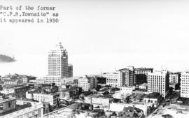
Portion of Vancouver, B.C. Looking Northeast
Part of Major Matthews collection
Photograph shows a view from the Hotel Vancouver showing part of the B.B. Johnson (Johnson and Howe) Block and the east side of the 600 Block of Granville Street including the New York Block and the Bank of Montreal
![[The Woodward's Department store beacon]](/uploads/r/null/2/9/2957b32c0aeee64fbd4fad1a307aedb3c507d878a8cb39c5a2d47149c8d52139/2494ae75-9091-45d8-a398-b5846c95993a-A43269_142.jpg)
[The Woodward's Department store beacon]
Part of Major Matthews collection
Woodward's "W" sign on the top of the building.

Vancouver, B.C. from Hotel Vancouver
Part of Major Matthews collection
Photograph shows the 600 Block between Howe Street and Granville Street including part of the C.P.R. Park, the Van Horne Building and Manor House
![[Looking east from the Stanley Park bridge to Coal Harbour]](/uploads/r/null/c/5/c5d5a12a1c9782ab5a8523900877fe279312841636d16b6c49d45f78c661b618/886c6082-bc19-41a2-a743-6880e2727074-A43209_142.jpg)
[Looking east from the Stanley Park bridge to Coal Harbour]
Part of Major Matthews collection
Photograph shows the B.C. Broom and Brush Works building

Part of Major Matthews collection
Photograph shows Christ Church Cathedral in the background

Vancouver, B.C. from Mount Pleasant
Part of Major Matthews collection
Photograph shows a view from west of Westminster Avenue (Main Street) looking north across False Creek
![[Looking northeast from Georgia Street from the Hotel Vancouver]](/uploads/r/null/8/a/8a3cf4ec45565ce8c42c5be70e3dc9bba77700670833bbf6543e337be1a6b54e/111407b8-0df6-4047-899b-7bcaf3802d1e-A43264_142.jpg)
[Looking northeast from Georgia Street from the Hotel Vancouver]
Part of Major Matthews collection
Photograph shows the east side of the 600 Block of Granville Street and beyond including the New York Block, the Simpson Block, the Crew Block, Homer Street Methodist Church, St. Anne's Academy and Holy Rosary Church (before the steeple was built)
![[Looking north from Georgia Street from the Hotel Vancouver]](/uploads/r/null/0/6/068fe03d8f45f3fc51aa86d37db6e46b2d340ec131401540ce8820b4a53f3e9a/fcf47eba-f8dc-43a3-ab61-1a71338fe9d8-A43263_142.jpg)
[Looking north from Georgia Street from the Hotel Vancouver]
Part of Major Matthews collection
Photograph shows the 500 and 600 Blocks of between Howe Street and Granville Street including part of the C.P.R. Park, the Japanese Consul, Manor House under construction, the Van Horne Block and the Bluff showing the homes of A.G. Ferguson and Harry Abbott in the background
Part of Major Matthews collection
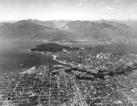
Oblique view showing the Burrard Bridge under construction, the Kitsilano Trestle, Granville and Cambie Bridges, Kitsilano, Granville Island, False Creek, Fairview, Mount Pleasant, Yaletown, Downtown, West End, Stanley Park and Vancouver Harbour
![[View of Vancouver and the North Shore mountains looking north from Little Mountain]](/uploads/r/null/9/8/981193e0442c45e0c77d4ab9d8eda9915696ec692f20796757988aaaae3ebc85/8ffa8758-16aa-423e-8dae-8e5b9b347636-A09870_142.jpg)
[View of Vancouver and the North Shore mountains looking north from Little Mountain]
Part of Major Matthews collection
![[View looking west from Vancouver Heights]](/uploads/r/null/a/b/abea52b2244ba2c43a15267f493517e431d982047fad5ea7c13c63bddecd73d7/468decc1-9f9c-4c9f-ad94-d67f993c03b8-A09869_142.jpg)
[View looking west from Vancouver Heights]
Part of Major Matthews collection
Photograph shows waterfront houses in Burrard Inlet with boats and log booms across the inlet , the Hastings-Sunrise district and Stanley Park in the distance.
![[View looking north from Vancouver Heights]](/uploads/r/null/d/0/d01f859748c2b49b352f6675548a9d5540240cb13dc8ce91f08489f51ba0deeb/81538f27-a410-4155-bffa-e67b2d2383e6-A09868_142.jpg)
[View looking north from Vancouver Heights]
Part of Major Matthews collection
Photograph shows dredging equipment and log booms in Burrard Inlet, a dirt road in front of a yard and forest and mountains in the background.