
Vancouver city and suburban lines
- AM1594-: MAP 813-: LEG1800.002
- Part
- 1923
Part of City of Vancouver Archives technical and cartographic drawing collection
Part consists of a map of streetcar and interurban rail lines in Vancouver.
Vancouver city and suburban lines
Part of City of Vancouver Archives technical and cartographic drawing collection
Part consists of a map of streetcar and interurban rail lines in Vancouver.

Map and Guide to Vancouver Street Car and Interurban Lines
Part of City of Vancouver Archives technical and cartographic drawing collection
Part is the front side of an informational pamphlet published by the BC Electric Railway Co. regarding City streetcar routes and interurban lines, golf and country clubs, city trips, interurban trips, motor coach trips, stations, ferries and docks, bathing beaches, public parks, North Shore canyons and parks, athletic and amusement parks.

British Columbia Electric Railway Company Limited : Vancouver Island system and Mainland system
Part of City of Vancouver Archives technical and cartographic drawing collection
Part contains two maps showing city, suburban, and interurban railway lines, transmission lines, generating stations, substations, and transformers.

Part of City of Vancouver Archives technical and cartographic drawing collection
Part contains a map showing street car, interurban, and motor bus lines in from Vancouver to New Westminster, a map showing existing and projected power plants near Alouette and Stave Lakes, and a profile showing the existing and proposed plants.

Vancouver city and suburban lines
Part of City of Vancouver Archives technical and cartographic drawing collection
Part is the back side of an informational pamphlet published by the BC Electric Railway Co. showing street car lines, interurban lines, bus routes and parks.

The Estate of Joseph Martin, K.C., MP
Part of City of Vancouver Archives technical and cartographic drawing collection
Part is the front side of the fold-out brochure; it includes promotional information about the estate, Vancouver, the climate, economy, land speculation in the city.

Standard tourist's guide to Stanley Park, a few facts about Vancouver : back cover
Part is the back cover of pamphlet and contains facts about the City of Vancouver.

Standard tourist's guide to Stanley Park : cover page
Part is the cover page for pamphlet about Stanley Park featuring a photo captioned: "Lily Pond and Band Stand at Refreshment Pavilion" taken by Gowen-Sutten & Co. Ltd.

Standard tourist's guide to Stanley Park : Index to points of interest
Part is the index to points of interest found on the Stanley Park map in pamphlet. Includes automobile routes, street car routes to park, viewpoints, gardens, and bodies of water.
How to see Vancouver, Canada : side 2
Part contains a day by day guide to visiting Vancouver for tourists and information on street car rides and routes.

Vancouver location map : side 1
Part is an illustrated map showing Vancouver streets and some buildings from English Bay to Burrard Inlet to Heatley Avenue to Granville Island. Map contains two inset photos of the Auto Camp at Hastings Park and the Suspension Bridge at Capilano Canyon with text.

Vancouver location map : side 2
Part contains advertisements for Vancouver retail shops, hotels, B.C.A.A., and restaurants and three inset maps. Maps show cities between Ashford, Washington and Vancouver, B.C., Union Steamship Company sea trips in Howe Sound, and recommended motor trips and routes around Vancouver.

Indexed map of Greater Vancouver : side 2
Part contains a map of the Greater Vancouver area from Gulf of Georgia to Frederick Road to Craig Street to Lulu Island, accompanied by an index of street names.
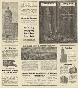
Indexed map of Greater Vancouver : side 1
Part contains advertisements for Bekin Moving and Storage Co. and the Bekin Building. Part contains illustrations of the Vancouver Depository, Seattle Depository and Portland Depository buildings, and an image of a panoramic view of the North Shore.
Municipality of Point Grey : sale of municipal-owned lands
Part of City of Vancouver Archives technical and cartographic drawing collection
Part contains text advertising properties in Point Grey and information on utilities, parks, schools, and property values in the municipality.
Part contains a commercial and visitors map of the southwestern land districts of British Columbia, encompassing Vancouver Island and the mainland from Seymour Inlet in the northwest to Black Pines in the northeast, extending south to Chiwaukum, Washington. Primary map shows settlements, government agent offices, mining and sub-mining recording offices, game reserves, customs posts, hospitals, ferries, campsites, golf courses, canneries, commercial air harbours, lighthouses, radio stations, motor boat refill stations, power sites, railways, roadways, trails, telegraph and telephone lines, steamship routes, topographic contour lines, and locations of falls and rapids. Text on the map provides information on land features and the presence of wild and farmed animals, and indicates current and possbile agricultural and industrial land use. Inset maps show the northern tip of Vancouver Island, Triangle Island and West and East Haycock Islands, and northwestern Washington State from Seattle to Centralia. A key map shows the location of the area covered by the main map in relation to the rest of North America.

Automobile road map of Vancouver Canada : side 1
Part contains textual information including points of interest, Canadian customs regulations, ferry timetables and rates. Part also contains two inset maps. A map of the Okanagan Circuit is in the top left corner, showing town names and a distance table with distances of towns from Vancouver in miles. A map showing ferry routes in the Gulf of Georgia is located in the middle of part.

Automobile road map of Vancouver Canada : side 2
Part contains a map showing major automobile roads extending from English Bay to The Lions to Clayburn to Blaine, Washington. Roads are shown in red. An inset map showing a continuation from Mission and Huntingdon to Harrison Hot Springs is located in top right corner of part.

Sale of municipal lands : Point Grey : map showing location of lots to be sold
Part of City of Vancouver Archives technical and cartographic drawing collection

University Hill : the residential section of Greater Vancouver : side 1
Part contains a map showing properties, with lot numbers and prices, for sale from Westbrook Crescent to Chancellor Boulevard to Acadia Road to Toronto Road. A legend showing the zoning for each property accompanies the map.

University Hill : the residential section of Greater Vancouver : side 2
Part contains textual information about purchasing properties in University Hill including information about general terms, sites, building requirements and restrictions, taxes and charges, transportation, and loans. Part also includes four photographs showing views of the properties .

Westmount Park : the subdivision superb : side 2
Part contains information about purchasing lots in Westmount Park and is accompanied by two inset maps. One map shows the lots for sale from Blanca Street to Belmont Drive to Tolmie Street to Second Avenue, their numbers and a price list, the other map shows where Westmount Park is situated in Vancouver.

Greater Vancouver road map : map cover
Part of City of Vancouver Archives technical and cartographic drawing collection

Map of downtown section of Vancouver ; Diagram of New Westminster, B.C., downtown section
Part of City of Vancouver Archives technical and cartographic drawing collection
Part contains road maps of downtown Vancouver and New Westminster, and textual information for tourists and motorists.

Automobile road map of Greater Vancouver and environs : map cover
Part of City of Vancouver Archives technical and cartographic drawing collection
Map cover includes advertisements for Eng Chow Company and Happyland.

Part of City of Vancouver Archives technical and cartographic drawing collection

Part of City of Vancouver Archives technical and cartographic drawing collection

Map of Greater Vancouver and environs showing principal auto roads and highways
Part of City of Vancouver Archives technical and cartographic drawing collection

Tourists' map of Greater Vancouver : inside cover
Part consists of the inside cover of pamphlet containing information about David Spencer Limited.

Map of Greater Vancouver and environs showing principal auto roads and highways
Part of City of Vancouver Archives technical and cartographic drawing collection

Map of downtown section of Vancouver ; Diagram of New Westminster, B.C., downtown section
Part of City of Vancouver Archives technical and cartographic drawing collection
Part contains road maps of downtown Vancouver and New Westminster, and textual information for tourists and motorists.

Part of City of Vancouver Archives technical and cartographic drawing collection
Part is a map of a portion of the Rocky Mountains including Rocky Mountains Park, Yoho Park, Kootenay Park, Glacier Park, and Revelstoke Park. Map shows rail lines, steamship routes, roads, trails, waterfalls, glaciers, rivers, elevations, and locations of amenities.

Westmount Park : the subdivision superb : side 1
Part is the cover page showing an illustration of the area of Westmount Park.

Part consists of a map of Greater Vancouver. Map extends from Howe Sound to Dome Mountain to Pitt River to Lulu Island. Map shows principal street names, golf and country clubs, bodies of water and city limits. Part contains textual information about parking regulations for the David Spencer store.

Tourists' map of Greater Vancouver : map of downtown Vancouver and map of New Westminster
Part contains a map of Downtown Vancouver, a map of the downtown section of New Westminster, and information for tourists including interesting facts about Vancouver. Maps show principal street names and some building names.

Automobile road map of Greater Vancouver and environs : inside map cover
Part of City of Vancouver Archives technical and cartographic drawing collection

Tourists' map of Greater Vancouver : cover
Part contains the front and back covers of the pamphlet, a map of Downtown Vancouver, a map of the downtown section of New Westminster, and information for tourists, including interesting facts about Vancouver. Maps show principal street names and some building names.
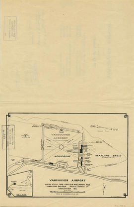
Part of City of Vancouver Archives technical and cartographic drawing collection
Part is a map shows a proposed plan for the design of Vancouver Airport at Spanish Banks, along with surrounding gardens, a stadium, parks and beaches.

Vancouver airport. Design for Spanish Banks
Part of City of Vancouver Archives technical and cartographic drawing collection
Part is the front page of a brochure, showing cost estimates for various elements of the development.

Greater Vancouver votes October 17th : know your ward - know your poll
Part of City of Vancouver Archives technical and cartographic drawing collection
Part contains a map showing ward and poll numbers and locations in the City of Vancouver from Burrard Inlet in the north to the Fraser River in the south and from Boundary Road in the east to Blanca in the west.
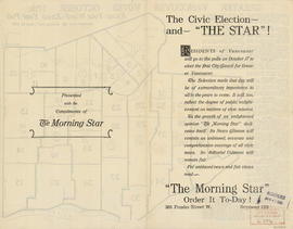
The civic election - and "The Star"!
Part of City of Vancouver Archives technical and cartographic drawing collection
Part contains text advertising The Morning Star newspaper and assuring readers of its political neutrality.

Greater Vancouver votes October 17th : know your ward - know your poll
Part of City of Vancouver Archives technical and cartographic drawing collection
Part contains a map showing ward and poll numbers and locations in the City of Vancouver from Burrard Inlet in the north to the Fraser River in the south and from Boundary Road in the east to Blanca in the west. Map has been annotated by Major J.S. Matthews to show mayoralty election results by ward.

The civic election - and "The Star"!
Part of City of Vancouver Archives technical and cartographic drawing collection
Part contains text advertising The Morning Star newspaper and assuring readers of its political neutrality.
![Howe Sound - Burrard Inlet [Howe Sound portion]](/uploads/r/null/7/a/1/7a1896077ddc37a7e16ac2d7e42a66031e13e11a9d966c43fca06cbb56f8bd96/5edd8d92-d3cd-4663-8fdd-996b3ae7a402-MAP30a_142.jpg)
Howe Sound - Burrard Inlet [Howe Sound portion]
Part of City of Vancouver Archives technical and cartographic drawing collection
Part shows the Lower Mainland and Howe Sound from Britannia Beach in the northwest to Indian Arm in the southeast. Map shows topographic contour lines, elevations, lakes, streams and other natural features, roads, railways, communication lines, cities and other settlements, and land, timber, and mineral surveys by number.
![Howe Sound - Burrard Inlet [Burrard Inlet portion]](/uploads/r/null/f/8/5/f8523992bb5d5e0c1391f2dea183041a54a2d2470eb4047bb29958a0d835ae95/fdf9563d-923e-468a-a494-3ff190294b91-MAP30b_142.jpg)
Howe Sound - Burrard Inlet [Burrard Inlet portion]
Part of City of Vancouver Archives technical and cartographic drawing collection
Part shows the Lower Mainland and Burrard Inlet from Howe Sound in the west to Indian Arm in the east. Map shows topographic contour lines, elevations, lakes, streams and other natural features, roads, railways, communication lines, cities and other settlements, and land, timber, and mineral surveys by number. Includes a list of sources of information.
![Sheet No. 1 [Ontario Street to 16th Avenue to Cambie Street to 23rd Avenue]](/uploads/r/null/4/d/d/4dd3d21cd72c689cdfec84f31637e9a1c0960c1d2d6d15e3441fafba4e5c91ee/8198c61c-ff71-45ed-b5c5-3e2c8c212922-LEG1153_142.jpg)
Sheet No. 1 [Ontario Street to 16th Avenue to Cambie Street to 23rd Avenue]
Part of City of Vancouver fonds
![Sheet No. 5 [Ontario Street to Forty-fifth Avenue to Cambie Street to Forty-ninth Avenue]](/uploads/r/null/1/f/1/1f17e485ff8505c9ad9b4316c404cfff72e76d3f9918a678f98247b5281f765e/dd6f5950-270a-4467-b83f-26a0bc4752f4-LEG1153_142.jpg)
Sheet No. 5 [Ontario Street to Forty-fifth Avenue to Cambie Street to Forty-ninth Avenue]
Part of City of Vancouver fonds
![Sheet No. 8 [George Street to King Edward Avenue to Ontario Street to Thirtieth Avenue]](/uploads/r/null/f/0/7/f077d1dfb6f6da927e00bd6cd4e3944aba3ea7a93b1c2076a280a8e003fb7b59/c0c04996-4ae8-4163-bab7-7398e0b0942a-LEG1153_142.jpg)
Sheet No. 8 [George Street to King Edward Avenue to Ontario Street to Thirtieth Avenue]
Part of City of Vancouver fonds
![Sheet No. 9 [George Street to Thirtieth Avenue to Ontario Street to Thirty-eighth Avenue]](/uploads/r/null/c/8/c/c8c223273de73dd975de4d45feac09eec2dcfde8226aaa0e1b8f1426493a4389/bc29ee5f-42d7-4859-990c-c55084703959-LEG1153_142.jpg)
Sheet No. 9 [George Street to Thirtieth Avenue to Ontario Street to Thirty-eighth Avenue]
Part of City of Vancouver fonds
![Sheet No. 10 [George Street to Thirty-eighth Avenue to Ontario Street to Forty-fifth Avenue]](/uploads/r/null/c/7/b/c7b4c32e4e766f9f7bbb885b57274132350e9acb7f1ca1595e42ccb2424079e6/b422e91a-0aba-46ea-9c43-9684ffe01f17-LEG1153_142.jpg)
Sheet No. 10 [George Street to Thirty-eighth Avenue to Ontario Street to Forty-fifth Avenue]
Part of City of Vancouver fonds