
- AM1594-: MAP 50
- Item
- Mar. 6, 1893
Part of City of Vancouver Archives technical and cartographic drawing collection
Item is a sheet with three nautical charts. The main chart depicts Burrard Inlet from Atkinson Point [Point Atkinson] in the west to the "townsite of Port Moody" in the east. The inset charts depict Vancouver Harbour and the Second Narrows.


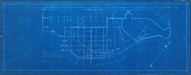
![[Map of Pioneer Place showing the area deeded to the City of Vancouver by the C.P.R.]](/uploads/r/null/4/1/41ba387b96586eb8554abcbf013c0e5cfbb116a42c8d1d1d2311fb1856694b2a/e3bd79d3-cd72-42e4-aa51-bc080514c205-MAP780_142.jpg)


![Map of the business portion of the City of Vancouver, British Columbia [early street paving]](/uploads/r/null/7/1/7187f671d2770050eb87f7f397a10ea92bf0bc593b0a186e3a4bf341b3d26e42/8770145a-b925-4eef-82ac-e397f61a65aa-Map1163_142.jpg)


![Municipality of North Vancouver [Burrard Inlet]](/uploads/r/null/6/d/6d0d9a4b75b38672c56aa89a5984fe2d0e6d66be85f6f375cbe8e2fd7ac94a98/577914e1-3de2-478b-a629-5f391731387a-MAP588_142.jpg)


![Plan of town of Lonsdale : situate [sic] on harbour opposite City of Vancouver](/uploads/r/null/c/5/d/c5d4b56db1d7f9e1cf57dd5a974f6fcb23507e64543bad1bdd8f62139042389f/1cc57eaf-6c92-438e-a65d-335940738df7-MAP686_142.jpg)
![Plate A [Index map of Vancouver - western portion]](/uploads/r/null/0/d/0/0d022ba039f0508a397a4d35450b667671f0ef36fd388f800f51681434d2a2a9/795dc4f4-e794-4288-880d-6bd4de616417-1974-100_142.jpg)
![Plate 105 [Front Street to False Creek to Quebec Street to Dufferin Street]](/uploads/r/null/a/f/b/afbb9be25514350d408eefa5865173e3a489ecdb6752d6b3096564052b234ca4/8c126ea6-16bb-4f0b-8131-a16f2a686d95-1974-100_142.jpg)
![Plate 107 [Quebec Street to Dufferin Street to Manitoba Street to Fifth Avenue]](/uploads/r/null/0/d/7/0d79d0f2e59b2acf6f0b094b86112948aced989bd8c13eb8f8ac17f5cb05a1fd/b74906fe-c1a9-49b1-8bc5-37b4141108f6-1974-100_142.jpg)
![Plate 108 [Scotia Street to Front/Dufferin Streets to Quebec Street to Fifth Avenue]](/uploads/r/null/5/4/6/54625ed1d1a99824d0a91f9897950dc4d1691ce8f7fae7be8086e768e671ef0e/5da48b46-8a62-40b9-9992-0fcbe4e8b491-1974-100_142.jpg)
![Plate 109 [Victoria Drive to False Creek to Scotia Street to Fifth Avenue]](/uploads/r/null/c/f/7/cf796986affb1d4761889c3b98c83be508ab7b762a16dcde3f48354e496a910f/3e0ce046-091f-45fb-b3ec-8ef8d907b4c2-1974-100_142.jpg)
![Plate 116 [Victoria Drive to Dufferin Street/Fifth Avenue to Scotia Street to Eighth Avenue]](/uploads/r/null/a/4/8/a48d7c5927867042c40b8415d5b33492b6ba8385e375aec78a675f2d3859417a/0dac58ba-008b-4d37-8ea2-aabfd1cb96d8-1974-100_142.jpg)
![Plate 118 [Burns Street to Seventh Avenue to Carolina Street to Tenth Avenue]](/uploads/r/null/1/3/d/13d0f752a2256754eef1871ceaee111678790dfc9ac08ab3515e1d24051659bc/b001c220-4630-4f03-bbd4-e73eaafe8133-1974-100_142.jpg)
![Plate 123 [Victoria Drive to Eigth Avenue to Scotia Street to Eleventh Avenue]](/uploads/r/null/8/7/7/877219ac8c7a9bd7a9f4f1affe532e0433280f5133544dd5bc24ba78306876e9/3b86ff00-0f66-44a6-a2ca-f716bd507388-1974-100_142.jpg)
![Plate 135 [Quebec Street to Fourteenth Avenue to Manitoba Street to Seventeenth Avenue]](/uploads/r/null/e/2/c/e2cb462b960ca9d4c0d5b97180db2dd920b833da6c49e5d51c8e95bf106ef7db/87724ebf-1228-4869-bb46-03f26e327563-1974-100_142.jpg)
![Plate 140 [Block east of Pine Street to Kitsilano Indian Reserve to Cedar Street to Third Avenue]](/uploads/r/null/7/e/8/7e8970e4b38be59229b38f8b6eb9833bfce0ac4b6b5ab287ecc09ff682cebecc/42fb5df2-2281-4cc9-a83f-44f82f9e47c3-1974-100_142.jpg)
![Plate 141 [Granville Street to False Creek to block west of Fir Street to Third Avenue]](/uploads/r/null/b/2/5/b255e765c266c20bfe0a9abc3dde1bf65002ca267675bad2dadafa4474df0196/b7dbabfa-7bf6-4bd3-b4e0-15d4a69b2877-1974-100_142.jpg)
![Plate 142 [Block east of Yew Street to Third Avenue to Vine Street to Sixth Avenue]](/uploads/r/null/4/1/b/41bfdfad990b2c36b8c65458c9a335d7188fa3e2385c910acd6f933a1f61eea9/b93009cb-1ffe-4031-a009-d2f37f20b9c1-1974-100_142.jpg)
![Plate 149 [Maple Street to Sixth Avenue to block west of Arbutus Street to Ninth Avenue]](/uploads/r/null/1/f/f/1ff5adea07e72b47fb8589cf72b5837f3f0cb33659dab5cf8869d5a88d99bde1/af236417-5448-45f0-93a1-6e86f77ec05e-1974-100_142.jpg)
![Plate 151 [Pine Street to Sixth Avenue to block west of Cedar Street to Ninth Avenue]](/uploads/r/null/e/4/9/e49218d46361f18de15f4b73198cc7b1fda01b9493e8cf55080a219b228f21dd/90857757-8cb5-40e3-89a3-1b9cb3f4107c-1974-100_142.jpg)
![Plate 155 [Spruce Street to Sixth Avenue to block west of Alder Street to Ninth Avenue]](/uploads/r/null/6/1/d/61d627b8bf8255c91caa4dae5c1414b7dea029c2d65ae523e8184113877d5762/9e7d5e21-01bf-448f-8037-73dd4abc4549-1974-100_142.jpg)
![Plate 157 [Willow Street to Sixth Avenue to block west of Laurel Street to Ninth Avenue]](/uploads/r/null/9/5/9/95917226a7f84bd48d88028f6821d6cb5ccdb9dc3b332600d85491dafd7539e6/e2de822d-869f-4fe6-b52b-84c3f4c8baac-1974-100_142.jpg)
![Plate 161 [Vancouver Lumber Co. site]](/uploads/r/null/8/5/2/852127f39051bf85e540ef01942067e3bc3fcf3dd7a1eb053622d2bd87407c8e/d10bf21c-a276-437b-9032-81dea28defdd-1974-100_142.jpg)
![Plate 163 [Key Plan of North Vancouver]](/uploads/r/null/e/1/d/e1d59c4aba0a20f0522dd57d1ecfbcc6fa0e15d2cb581616d819932b7b4485b7/be98b40c-82d0-4d47-97d2-e5bc54e3e904-1974-100_142.jpg)
![Plate 164 [Lonsdale Avenue to Second Street to Chesterfield Avenue to Burrard Inlet]](/uploads/r/null/b/c/5/bc5801cb1cab9f718c08d5e85247acf3c6c6d41621bd633be9636327b722a9cd/db55d2fa-bc36-4407-a98b-9c062774aa12-1974-100_142.jpg)
![Plate 101 [Alberta Street to False Creek to Bridge Street to Fifth Avenue]](/uploads/r/null/3/a/c/3ac4671c467690486217deca7d5b3609b605b6fc542b79fb134372abed97a952/1e879c50-27f7-4e55-8d48-ae8d72b27441-1974-100_142.jpg)
![Plate 102 [Front Street to False Creek to Cambie Street Bridge]](/uploads/r/null/2/3/4/23495fedf0cfd0840f946ff51151c2d620ac4381afedbd39cc496162211c108a/798a5687-2c56-4add-bf27-5adb8e27ebeb-1974-100_142.jpg)
![Plate 119 [Dock Street to Seventh Avenue to Burns Street to Tenth Avenue]](/uploads/r/null/d/7/c/d7cf9a44b79c3474cf22e547b284ddfb851d469419b4c16364c5bd62aacd6b8a/6ff5b121-a238-4b51-8586-2e9962088a05-1974-100_142.jpg)
![Plate 121 [Quebec Street to Eighth Avenue to Manitoba Street to Eleventh Avenue]](/uploads/r/null/a/f/1/af121e25c31c0cfec1192729732131e8c10fc3b73fef80730f442c4b8851d11e/1a24a04e-7d82-4800-96dd-ef72113c34a3-1974-100_142.jpg)
![Plate 122 [Scotia Street to Eighth Avenue to Quebec Street to Eleventh Avenue]](/uploads/r/null/8/8/1/881d5dea72196cae5eaf43f70c73e80c2fb405045a4bdf21ca39865bf3017c2a/f99553c0-92f4-46fe-8932-ac6c8ad65532-1974-100_142.jpg)
![Plate 124 [Manitoba Street to Eleventh Avenue to (Alberta Street) to Thirteenth Avenue]](/uploads/r/null/0/3/3/0331045db81038116690564c351783dc8e8fb7fae3cfa52380701e509111a189/550d93f8-8eec-475c-bce4-8f2b1036600f-1974-100_142.jpg)