
Sale of municipal lands : Point Grey : map showing location of lots to be sold
- AM1594-: MAP 554-: LEG1341.2
- Part
- 1925
Part of City of Vancouver Archives technical and cartographic drawing collection
10366 results with digital objects Show results with digital objects
Sale of municipal lands : Point Grey : map showing location of lots to be sold
Part of City of Vancouver Archives technical and cartographic drawing collection
![Plan of Point Grey Municipality [ward boundaries]](/uploads/r/null/a/c/a/aca691b3d6e49d092070fc230a88f5ca7bd346fc8c5894892d7cdc5a79b535ee/9a14b192-1858-43aa-ab28-d0b03a2304eb-MAP360_142.jpg)
Plan of Point Grey Municipality [ward boundaries]
Part of City of Vancouver Archives technical and cartographic drawing collection
Item is a copy of a commercially published map of Point Grey which has been used as a base map to depict existing and proposed new ward boundaries for Point Grey municipality.

Plan of government subdivision at Point Grey, B.C.
Part of City of Vancouver Archives technical and cartographic drawing collection
Item is a sheet which has been excised from the Journal of the Town Planning Institute, December 1925 issue. The sheet consists of two street layout plans and an illustration. The street layout plans show current and proposed revised street layouts for the area of Point Grey bounded by Highbury Street, Eighth Avenue, Imperial Street, and Tenth Avenue. The illustration depicts the view north from the proposed development area.

Lot numbers, boundaries, railway lines and street names in the municipality of Point Grey
Part of City of Vancouver Archives technical and cartographic drawing collection
Primary map shows lot numbers, boundaries, railway lines and street names in the municipality of Point Grey from 16th Avenue in the north to the Fraser River in the south and from Ontario Street in the east to Blanca Drive in the west. A smaller map in the bottom left-hand corner of the item shows the north west portion of Point Grey.

Plan of Point Grey Municipality
Part of City of Vancouver Archives technical and cartographic drawing collection
Item is map of the Municipality of Point Grey and parts of the City of Vancouver showing street car lines, district lot boundaries, postal block numbers and some street names. Map has been annotated with red dots in four locations, but the significance of the dots is unknown.

Part of City of Vancouver Archives technical and cartographic drawing collection
Item is a map showing major streets, lot numbers, lot boundaries and property sold or reserved in the area from Chaldecott Road (now King Edward Ave.) in the north to Magee Road (now W. 49th Ave.) in the south. Kaye Road (now Trafalgar St.), Wilson Road (now W. 41 Ave.), Bodwell Road (now W. 33rd Ave.) and Johnson Road (now Blenheim) are all included on the map.
![[Totem pole lying in house on Musqueam Reserve]](/uploads/r/null/9/0/908888d78da7c8729f10b467198042376a0e37f5852574f1925b844a1c3f54e9/9816a0f8-211b-4e42-8f0c-746803182c9f-A76381_142.jpg)
[Totem pole lying in house on Musqueam Reserve]
Part of James Crookall fonds
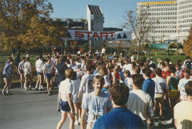
Arts 20 Relay Race participants at U.B.C. starting line

Arts 20 Relay Race participants at U.B.C.
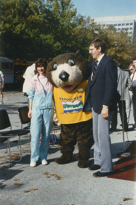
Tillicum posing with man and woman at the Arts 20 Relay Race

Tillicum on stage at dedication of Volunteer Park

Crowd with umbrellas gathered around stage at dedication of Volunteer Park

Group on stage at dedication of Volunteer Park
Item is a photograph showing a group on stage at the dedication of Volunteer Park. Mike Harcourt is pictured speaking into microphone. Michael Francis is shown to the left of Tillicum behind podium.

Crowd with umbrellas assembled around Chevron canopy at dedication of Volunteer Park

Road gang spreading asphalt, Imperial Street
Item is a photograph of a road gang spreading asphalt on macadam base on Imperial Street, Point Grey, Vancouver, looking northeast.
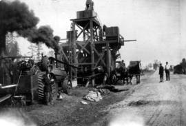
Item is a photograph of an asphalt plant set up beside an unpaved street in Point Grey. Also included are plant operators and a horse cart.

Old Hastings Mill Store Museum, interior
Part of Art Grice fonds
Item is a photograph of the interior of the Old Hastings Mill Store Museum (1575 Alma Street).

Cecil Green Park house, south-west facade
Part of Art Grice fonds
Item is a photograph of the southwest facade of Cecil Green Park House on the University of British Columbia campus.

Cecil Green Park house, dining room fireplace
Part of Art Grice fonds
![[Mr. and Mrs. Dagliesh and guests outside Dagliesh residence at Jericho]](/uploads/r/null/a/8/a821eae8ef05d3d4aba34c39fd92eeca38f811eeec3883da876ba133c95d2f00/a9819209-a857-466c-bd20-17e981e37c57-A03927_142.jpg)
[Mr. and Mrs. Dagliesh and guests outside Dagliesh residence at Jericho]
Part of Major Matthews collection
J.S. Matthews' notes with print or negative in Archives.

Item is a photograph showing a West Point Grey School (Queen Mary School, 2000 Trimble Street) under construction, with councilor Fred T. De Wolfe on right, man with surname Irons in centre and Billy De Wolfe on left.

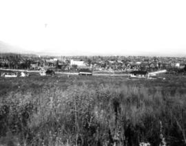
Left portion of Panorama, view from Point Grey
Part of C.F. Chapman fonds
Item is the left portion of a panorama, which with the following two views was taken looking north from 9th Avenue, about two blocks west of Alma.

Middle portion of Panorama, view from Point Grey
Part of C.F. Chapman fonds
Item is the middle portion of a panorama which was taken looking north from 9th Avenue, about two blocks west of Alma.
Right portion of Panorama, view from Point Grey
Part of C.F. Chapman fonds
Item is the right portion of a panorama which was taken looking north from 9th Avenue, about two blocks west of Alma.

Vancouver, British Columbia : south-westerly portion, formerly Point Grey : major street plan
Part of City of Vancouver Archives technical and cartographic drawing collection
Item is a map which has been removed from a copy of the report "A plan for the City of Vancouver, British Columbia, including Point Grey and South Vancouver and a general plan of the region", commissioned by the Vancouver Town Planning Commission from the planning consultants Harland Bartholomew & Associates.
The map shows existing and proposed additions to the major street plan in part of the city that is the former Municipality of Point Grey. The map also shows present street widths, lines of vehicles and roadway widths versus proposed street widths, lines of vehicles and roadway widths.
Harland Bartholomew and Associates

Rezoning application map (Point Grey Road)
Part of City of Vancouver Archives technical and cartographic drawing collection
Item is a map that would have been created to accompany an application for re-zoning for Block 235 D.L. 538 and water lots 5834, 5601 and 5600. It appears that this application failed, as no amendment to By-law 3575 for these properties has been found.
Vancouver (B.C.). Planning Department

Vancouver Harbour : Sheet 2 (Point Grey to Second Narrows)
Part of City of Vancouver Archives technical and cartographic drawing collection
item is a nautical chart of Burrard Inlet and Vancouver Harbour from Point Grey in the west to Second Narrows in the east, showing soundings in fathoms, tidal information, anchorages, beacons, and waterfront businesses. Street names are shown on land areas. A Royal Canadian Air Force bombing range at Jericho Beach is identified as a danger area.
![[View of 41st Avenue, looking west from East Boulevard]](/uploads/r/null/c/7/c7fd3880821ca2c44c301667b7256441ee8267b4995133ba0d66021082f51890/0725d08c-d670-4516-b846-b04995e36984-A08320_142.jpg)
[View of 41st Avenue, looking west from East Boulevard]
Part of Major Matthews collection
Photograph shows interurban line, municipal hall for Point Grey, and various businesses, including the Bank of British North America.
![[View of Hudson Street, looking south toward the Eburne Railway Station]](/uploads/r/null/e/0/e02af163a2bc02f2c8f814358e4f275fff14ea65f75638334d3f2247b2325e6d/19e19d75-4759-4c0e-97c1-fdcbd9c55151-A08302_142.jpg)
[View of Hudson Street, looking south toward the Eburne Railway Station]
Part of Major Matthews collection
![[View of Granville Street, looking north from Angus Street]](/uploads/r/null/7/a/7a1737054aa612c021baa18a1c213f921a3fde4a59ebbf1a2d04b50fe16cc3e1/845085b7-c5af-4c0f-87dc-2896df0ccb74-A08301_142.jpg)
[View of Granville Street, looking north from Angus Street]
Part of Major Matthews collection
J.S. Matthews' notes with print or negative in Archives.

First Jericho Country Club clubhouse
Part of Jericho Country Club fonds
Item is a photograph showing the first Jericho Country Club clubhouse. Writing on back: "reconstructed in 1907 from the old Dalgleish Building."

Man and woman on balcony of Jericho Clubhouse, looking across beach to north shore
Part of Jericho Country Club fonds

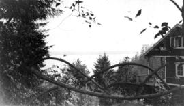
View looking north west from the Jericho Clubhouse
Part of Jericho Country Club fonds

Old cart bridge across slough on Jericho Golf Club property
Part of Jericho Country Club fonds
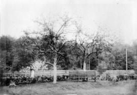
Garden surrounding original Jericho Clubhouse
Part of Jericho Country Club fonds
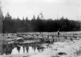
Woman on old footbridge crossing slough at Jericho Golf Club
Part of Jericho Country Club fonds

A. Kam on original first tee at Jericho Golf Course
Part of Jericho Country Club fonds

Man and woman on first green at Jericho Golf Course
Part of Jericho Country Club fonds

A. Kam, club professional, on fourth tee
Part of Jericho Country Club fonds

University Buildings Point Grey
Part of Major Matthews collection

Looking up Howe Sound from Point Grey
Part of William Orson Banfield fonds
![Sunset from the beach at P[oin]t Grey](/uploads/r/null/7/6/b/76be30ae171527a141b2373c3bcfae2948a2449e20f6d6d88ab849c57d575199/1c05b502-2cc6-43e2-954a-93a5185e455e-CVA289-003_142.jpg)
Sunset from the beach at P[oin]t Grey
Part of William Orson Banfield fonds
![Gywn [Lewis]'s birthday party on the beach at P[oin]t Grey](/uploads/r/null/2/b/0/2b0cc964c3af3caf6ae37f3149f74d6356d5e61c509b99adc1b43e98bf3ead98/7e8366e2-c3c3-413e-a44a-e030247caddd-CVA289-003_142.jpg)
Gywn [Lewis]'s birthday party on the beach at P[oin]t Grey
Part of William Orson Banfield fonds
Part of William Orson Banfield fonds
![On the beach at Point Grey : John [Banfield]](/uploads/r/null/2/1/f/21f0506f855c4156c7b1f6bb64a49cc3b1ec4a12dea67415f81f2fcec1a591a2/39e7e45b-d5f6-42aa-a6d8-122818abf68a-CVA289-005_142.jpg)
On the beach at Point Grey : John [Banfield]
Part of William Orson Banfield fonds
![On the beach at Point Grey : John [Banfield]](/uploads/r/null/d/8/6/d866e1427598481f43c9228347ffc687985839f3382fa9148b7a63c9b4b178cf/e2b37143-244e-4012-b782-b5dfb36fc1d3-CVA289-005_142.jpg)
On the beach at Point Grey : John [Banfield]
Part of William Orson Banfield fonds
![On the beach at Point Grey : Jane [Banfield]](/uploads/r/null/6/8/9/6895b418a59577dafac725bbc3b4d8096babf78c2ec7bc646aef5b025b100866/f30b4516-e4e9-4923-8ec0-64592e75f09f-CVA289-005_142.jpg)
On the beach at Point Grey : Jane [Banfield]
Part of William Orson Banfield fonds
![On the beach at Point Grey : John [Banfield]](/uploads/r/null/f/3/a/f3a62e3cff3818d07bfa0a70bf8062cd29a54b5696062fb29d137b7f5c239c97/be31885a-c14d-4238-b1d6-fcd1573657d3-CVA289-005_142.jpg)
On the beach at Point Grey : John [Banfield]
Part of William Orson Banfield fonds

Part of William Orson Banfield fonds
![[U.B.C. students] surveying on Marine Drive, Pt. Grey](/uploads/r/null/3/1/c/31c66d590722b7d5807d1b36f822b9d56e8dab7647d378308b99a0c3d593b35a/f5701aa1-8d83-4ca1-a401-022abd3ba116-CVA289-006_142.jpg)
[U.B.C. students] surveying on Marine Drive, Pt. Grey
Part of William Orson Banfield fonds