Print preview Close

Showing 783 results

Archival description
City of Vancouver Archives technical and cartographic drawing collection
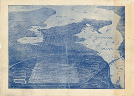
 Vancouver (B.C.)
Print preview View:

662 results with digital objects Show results with digital objects

Plan of the City of Vancouver

Item is a reduced size copy of the Hermon & Burwell map Plan of the City of Vancouver. This copy is ca. 1/4 the size of the original map. The map shows District Lots, blocks and lots; transportation infrastructure such as bridges and railway and streetcar lines; and the identification of some industries, especially along the various waterfronts.

Visitors map of Vancouver

Part is the front sheet of an unfolded tourism brochure showing Vancouver tourist attractions, The sheet includes a map of downtown Vancouver, with transportation information, a map of the roads in Stanley Park, photographs and information on various sites and attractions in the city, as well as general promotional information.

Dial map of Greater Vancouver

Part contains a street map of Vancouver showing streets, block numbers, bus routes, railway lines, boundaries, private roads and hospitals. The map includes a dial (a numbered circle, a paper indicator, a grid of block numbers and a street index used to find locations in Vancouver). A small inset shows the streets surrounding Queen Elizabeth Park, which are obscured on the main map where the indicator is attached.

Dial map of Greater Vancouver and suburbs

Part contains a street map of Vancouver, Burnaby, New Westminster, West Vancouver and North Vancouver showing block numbers, street car, bus, and railway lines, parks and hospitals. Map includes two dials (a numbered circle, a paper indicator, a grid of block numbers and a street index used to find locations). A small inset map shows the Capitol Hill/Scenic Park area of Burnaby in greater detail.

City of Vancouver : Canadian Pacific town site

Part contains four maps. The main map shows district lots and block numbers in Vancouver from Vine Street in the west to Boundary Avenue (Glen Drive) in the east and Stanley Park in the north to 9th Avenue (Broadway) in the south. Three smaller maps include an index plan to district lots in Vancouver, South Vancouver, New Westminster, and Burnaby; a world map showing Canadian Pacific mail steamship lines; and an index plan of Vancouver city limits.

Greater Vancouver votes October 17th : know your ward - know your poll

Part contains a map showing ward and poll numbers and locations in the City of Vancouver from Burrard Inlet in the north to the Fraser River in the south and from Boundary Road in the east to Blanca in the west. Map has been annotated by Major J.S. Matthews to show mayoralty election results by ward.

British Columbia Electric Railway Company Limited : Vancouver and New Westminster city and suburban lines and Alouette-Stave development, present and projected

Part contains a map showing street car, interurban, and motor bus lines in from Vancouver to New Westminster, a map showing existing and projected power plants near Alouette and Stave Lakes, and a profile showing the existing and proposed plants.

B.C. Electric guide to Greater Vancouver : Richmond transit system, downtown Vancouver transit system, street index, and general information

Part contains maps of the Richmond and downtown Vancouver transit systems, a street index to the Greater Vancouver map on the other side of the sheet, information on B.C. Electric transit routes, and general tourist information.

Results 151 to 200 of 783