![[View from the Fairview-Mount Pleasant area looking north]](/uploads/r/null/3/8/38e35eed76b25b54ee936c701665ac1b51730799bb74c0c6b4d3f6e35dfa4e02/ab6491d0-1922-485b-b624-dfb289594a9c-A65314_142.jpg)
[View from the Fairview-Mount Pleasant area looking north]
- AM1376-: CVA 1376-78
- Item
- [between 1922 and 1931]
Item shows houses under construction in the Fairview and Mount Pleasant neighbourhoods.
1392 results with digital objects Show results with digital objects
[View from the Fairview-Mount Pleasant area looking north]
Item shows houses under construction in the Fairview and Mount Pleasant neighbourhoods.
![[View of downtown Vancouver from the Fairview-Mount Pleasant area looking north]](/uploads/r/null/d/a/da0e60f039af32fb4e690e6f4fb4c0eb54e56e1da4db20349966b17c0d994822/d9027b1b-b0e1-4d17-acda-c126e0b6f82b-A37814_142.jpg)
[View of downtown Vancouver from the Fairview-Mount Pleasant area looking north]
Item shows neighbourhood rooftops in the foreground and the downtown core in the background.

Photograph shows a view through the trees at low tide
![[View of Burrard Inlet through the trees]](/uploads/r/null/5/9/590fb56f965b894116f0d1dbb79d0122a0813f47e295e765f49292f1614f30ae/3d5aa8b3-f909-4f46-a7de-4414b7f95ad6-A71827_142.jpg)
[View of Burrard Inlet through the trees]
![[View across Burrard Inlet]](/uploads/r/null/1/2/120557e4082af4150437cc4b0af4cd4885591148557c840770507732a02bdf90/e450bfc2-8bdb-4c36-9ef3-9596c3c07c05-A71828_142.jpg)
![[View of English Bay through the trees]](/uploads/r/null/d/2/d25da78719a2f9e571c17517ae27aab92f93704236d13051f62a33ec7763f8d6/cde74a64-71dd-490c-b1e4-0f70608a3856-A71830_142.jpg)
[View of English Bay through the trees]
![[View towards Siwash Rock]](/uploads/r/null/7/7/779620b766a84ada8014c41142eeef05a7912fe697fb02e741c241f21c523ba1/61dcb26c-d9ae-4d0d-b7fb-c183c593d077-A71841_142.jpg)

![[View across English Bay before sunset]](/uploads/r/null/c/4/c492d74d447fa3723b0f1f8792f07ef0a75925dbcc50bd049efcc241b304b7de/1cc5bb50-849c-4301-9f26-b0733ee22631-A71843_142.jpg)
[View across English Bay before sunset]
![[View across the water]](/uploads/r/null/5/5/5584645d3041bf259c3284446d9663897ef5ba6c50ca06fcf8f9f36b0a2fb794/8672e91c-e50c-4cf4-8341-4304da7f549a-A71846_142.jpg)
![[View of sailboats on English Bay]](/uploads/r/null/e/3/e3b8da1a59bb943522a93c5dc7e92142f74b5f05bf79f281aa5a543c7c7f978a/71c8c866-d1d8-4b09-9b04-ca15f9464dca-A71848_142.jpg)
[View of sailboats on English Bay]
![[View across the water towards Howe Sound]](/uploads/r/null/6/b/6b70b34bdcadd2bd086ee551fae15923dce32bdca19be01e4cc65090867a1f13/0fa5dded-ed63-472d-87bb-c96aeb830017-A71850_142.jpg)
[View across the water towards Howe Sound]
![[View of a distant steamboat]](/uploads/r/null/4/0/40ed66f6f7fe67ddb40836f5a85db6555331e98f8387f4651b1e2527ec0ae014/ed0fff23-ccb5-477a-897b-1d8341d26c04-A71851_142.jpg)
![[View of sunset over English Bay]](/uploads/r/null/7/a/7a49baa8205a2bb2570359553b782a300d7937bc8e532a64394695aaf0bfe2d0/78976384-d308-4711-82f5-b257b198919a-A71852_142.jpg)
[View of sunset over English Bay]
![[View looking north along Yew Street from 4th Avenue]](/uploads/r/null/c/1/c16377a14f374a2a2726f1ca3893861189536b321cc8ed7733f0faac95825be6/66978367-ca40-4e36-87c5-6137d1ad3f43-A71855_142.jpg)
[View looking north along Yew Street from 4th Avenue]
Photograph shows people walking on a wooden sidewalk, a sign for James Eadie Real Estate (at York Avenue), Kitsilano Beach, bathhouse, bandstand and Stanley Park in the background
![[People sitting on benches enjoying the view]](/uploads/r/null/f/2/f2297a6ddaf371b8434aa486cb82614fdd15854c1c4abf09f4a48a8d0b227e32/46e5f70e-2dfd-4622-8d9f-46411a65da05-A71861_142.jpg)
[People sitting on benches enjoying the view]
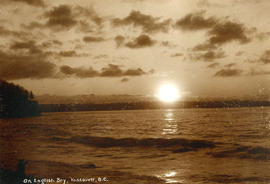
On English Bay, Vancouver, B.C.
Photograph shows the setting sun
![[View towards Point Grey]](/uploads/r/null/6/4/64d0516f86d40e8ebd5d19468837059cd6ee410295d69470fe1c3774fa8eb260/3b4aa37b-8468-4dd2-95f0-725226457dc8-A71868_142.jpg)

Panoramic view. Image is one of two panoramas mounted on board to show the changes in the cityscape between circa 1890 and 1923.
Panoramic view. Image is one of two panoramas mounted on board to show the changes in the cityscape between circa 1890 and 1923.
![[View looking south from the north end of the second Granville Bridge]](/uploads/r/null/a/c/acf4d1c8aea3aa91ce69f0e772e25c42e06280ab6fdc8ffd7237b665cecdbe3a/5747d652-05a3-4b69-95e4-8849829ea0ae-A47613_142.jpg)
[View looking south from the north end of the second Granville Bridge]
Part of City of Vancouver fonds
Photograph shows part of the Continental Hotel and the National Furniture clock
![[Katherine Federici at the top of the Empire State Building in New York City]](/uploads/r/null/2/7/27d635d4f98ab30d6596d4d34ed251426760a748888c6620679bf95e87651220/0b86076c-30e3-4fac-9c0c-a32181342c7f-CVA1477-891_142.jpg)
[Katherine Federici at the top of the Empire State Building in New York City]
Part of L.D. Taylor family fonds
![[View of Downtown looking north from Burrard Street near Smithe Street]](/uploads/r/null/5/5/55d8edafe09d551a1b347d53f583ba1f176584e2e5179909aed5e5d271bdf50e/49a94ff1-b4b2-467a-b48f-950b069fbb57-A63342_142.jpg)
[View of Downtown looking north from Burrard Street near Smithe Street]
Part of John William Freeston fonds
Panoramic view showing the Irwinton Apartments, the courthouse, the second Hotel Vancouver, the Vancouver Block, Granville Mansions and the Hotel Barron
![[View looking north from Cordova Street and Cambie Street]](/uploads/r/null/2/d/2d9e6f0e416fa8ec61ab908a1fecadeea3985ab00b8fb383d777fabc0b020280/5c46a943-93a4-4503-95d1-453fc7aa6646-A60868_142.jpg)
[View looking north from Cordova Street and Cambie Street]
Part of John William Freeston fonds
Panoramic view showing Brockton Point, Pier D and the wharves east including the Union Steam Ship Company dock, the north side of the 300 Block Water Street and the Leckie Boot Company

View of Vancouver Harbour from Tower Building
Part of John William Freeston fonds
Panoramic view from taken from on top of the Tower building at 500 Beatty street looking northwest and northeast showing such sites as the Universal Knitting Company, the Bank of Hamiltion, Spencers Department Store, the Dominion Building, the Leckie Boot Company, Woodwards water tower, Orpheum Theatre, Pantages Hotel, McLennan and McFeely Co., Pier D, the Union Steam Ship dock and the wharves east and Brockton Point and Burrard Inlet in the background. Photograph also shows various billboards and painted advertisements such as Britannia Beer.

R.M.S. "Empress of Russia" in Vancouver Harbour
Part of John William Freeston fonds
Panoramic view showing Burrard Inlet, the Immigration Building, C.P.R. Pier A, C.P.R. Pier D, Pier B-C construction site and Deadmans Island, Coal Harbour, Brockton Point and the Lions in the background
![[View of Vancouver Harbour and waterfront looking north]](/uploads/r/null/8/a/8ac88e032f61ec518dc9db5cf599c0aba57a3464e9ef196b0e9d7f900c5a4592/31479d67-42ce-4888-afbf-eb5e079d5850-A60955_142.jpg)
[View of Vancouver Harbour and waterfront looking north]
Part of John William Freeston fonds
Panoramic view showing Burrard Inlet, the Immigration Building, The "Edmore" at C.P.R. Pier A, C.P.R. Pier D, Pier B-C construction site and the Vancouver Riowing Club, Deadmans Island, Coal Harbour, Brockton Point and the Lions in the background

Part of John William Freeston fonds
Panoramic view showing McLennan's Drug Store, Western Modern Business School, Columbia Street including City Hall and part of the Fraser River Bridge

Part of John William Freeston fonds
Panoramic view showing the inner harbour, The Empress Hotel and Government Street, the Grand Truck Pacific and other docks and the cupolas of the parliament buildings
Part of John William Freeston fonds
Panoramic view showing fuel oil tanks at the foot of Bute Street, Coal Harbour, the Vancouver Rowing Club, Deadmans Island, Brockton Point, the C.P.R. freight car ferry dock, the Immigration building, C.P.R. Pier A and Pender Street west of Burrard Street

Western Terminus of Canadian Pacific Transcontinental R.R. and Burrard Inlet, Vancouver, B.C., Can.
Part of H.A. Price collection
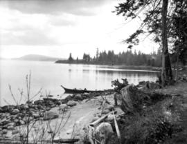
Photograph shows Deadman's Island in the distance.
![[View of a] Portion of Deadman's Island, from Stanley Park, Vancouver, B.C.](/uploads/r/null/b/f/bf5e29ae7128b1108684923d8b4fdac96706593b1c652af36bbfcbd8d8bc605a/1366542b-303d-4682-81f0-2b9548dab407-A19513_142.jpg)
[View of a] Portion of Deadman's Island, from Stanley Park, Vancouver, B.C.
Part of Richard H. Trueman fonds
Photo shows shacks near the shore.
![[View looking north along the Granville Bridge towards the Continental Hotel]](/uploads/r/null/9/a/9ad9b43959bfac5892268daa60983d651f1eda935a7f3b64a61e029ce6cb1fbd/4a2fa44c-7f4e-41b9-911d-a15ccf2ac1be-A20303_142.jpg)
[View looking north along the Granville Bridge towards the Continental Hotel]
Part of Major Matthews collection
Photograph shows the shadow of the photographer on the wooden sidewalk, the billboards on the west side of the bridge and a Wild Rose Flour sign on the side of the hotel in the background

Part of Major Matthews collection
Photograph shows a view looking southeast from the Granville Bridge towards a potential site for a billboard at Athletic Park at 5th Avenue and Hemlock Street
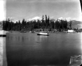
View of mountains from Stanley Park
Part of C.F. Chapman fonds
Item is a photograph showing a view of the mountains from Stanley Park, looking across Coal Harbour, before the causeway to Stanley Park was built.
Part of C.F. Chapman fonds
Item is a photograph showing a view from the shore in Stanley Park, looking east towards Brockton Point, with a canoe visible.

Part of C.F. Chapman fonds
Item is a photograph showing the view south towards Vancouver, taken from the western reaches of Grouse Mountain.

Part of C.F. Chapman fonds
Item is a photograph showing the view south towards Vancouver, taken from the western reaches of Grouse Mountain.
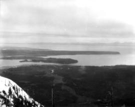
Part of C.F. Chapman fonds
Item is a photograph showing the view south towards Vancouver, taken from the western reaches of Grouse Mountain.

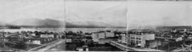
Left portion of Panorama, view from Point Grey
Part of C.F. Chapman fonds
Item is the left portion of a panorama, which with the following two views was taken looking north from 9th Avenue, about two blocks west of Alma.

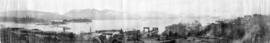
Middle portion of Panorama, view from Point Grey
Part of C.F. Chapman fonds
Item is the middle portion of a panorama which was taken looking north from 9th Avenue, about two blocks west of Alma.
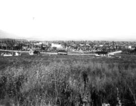
Right portion of Panorama, view from Point Grey
Part of C.F. Chapman fonds
Item is the right portion of a panorama which was taken looking north from 9th Avenue, about two blocks west of Alma.
![Looking south east in snow [from R.W. Jackson's home at 8635 S.W. Marine Drive]](/uploads/r/null/6/8/3/683361c433cc04b6e7f5ebf989828bbf228d5e26ad684007cce6a68312662589/38a0585f-3e03-4a3c-a0a9-811c6eb5e0e8-CVA217-007_142.jpg)
Looking south east in snow [from R.W. Jackson's home at 8635 S.W. Marine Drive]
Part of Robert W. Jackson fonds
![Looking south in snow [from R.W. Jackson's home at 8635 S.W. Marine Drive]](/uploads/r/null/a/6/a/a6a7f9f69b947fa0a1e3edf198ee85b701ad37e513b85e4ba6502b5afbeb1316/100f9992-e239-4388-a3e8-a1b79c9a5d51-CVA217-008_142.jpg)
Looking south in snow [from R.W. Jackson's home at 8635 S.W. Marine Drive]
Part of Robert W. Jackson fonds

Looking across English Bay from the beach on Point Grey Road

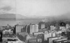
View looking north east over downtown Vancouver towards Burrard Inlet

View looking north over downtown Vancouver, across Burrard Inlet to North Shore
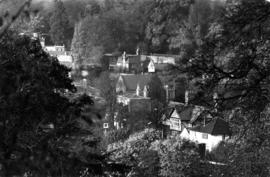
View of the village of Petersham, Surrey, England

Item is a photograph showing a view of Granville Street looking north towards C.P.R. Station and North Shore Mountains.