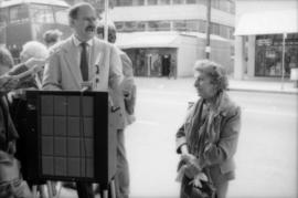
Mike Harcourt and Theresa Galloway at drinking fountain inauguration
- COV-S477-3-F111-: CVA 775-189-: CVA 775-189.22
- Part
- Oct. 1, 1986
Part of City of Vancouver fonds
435 results with digital objects Show results with digital objects
Mike Harcourt and Theresa Galloway at drinking fountain inauguration
Part of City of Vancouver fonds

Mike Harcourt drinking from fountain
Part of City of Vancouver fonds
Part of City of Vancouver fonds
Item is the first part of an audio reel containing a recording of notes taken from the Summary Record of the Provincial Civil Defence Coordinators' conference in Ottawa on October 5th and 6th, 1959. The speaker is unidentified.
![[Musqueam Reserve to Thirty-sixth Avenue to Highbury Street to 51st Avenue]](/uploads/r/null/a/7/4/a74224e4022dc88e8b13a29140d83a942901fb10319f1d8a1d038a6a65a4a96f/365ff516-870b-42ef-a287-59b4e77e2d52-LEG1319_142.jpg)
[Musqueam Reserve to Thirty-sixth Avenue to Highbury Street to 51st Avenue]
Part of City of Vancouver fonds
National Conference of Emergency Health Services
Part of City of Vancouver fonds
Item is the second part of an audio reel containing a recording of notes taken from the report by Brigadier Lister to Brigadier McArthur on the National Conference of Emergency Health Services from November 16-19, 1959 at the Civil Defence College,[Arnprior], Ontario.
Part of City of Vancouver fonds
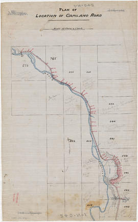
Part is the northern half of a map of the Capilano River, depicting the area of the Capilano River valley from District Lots 595 and 602 north to the dam located in District Lot 673.
![[Oak Street to Fifty-fourth Avenue to Manitoba Street to Vancouver Lulu Island Railway]](/uploads/r/null/0/9/7/0976df82489458d98f615a2b702148e41903da24caf32e8538b9e9c2cf424e4b/2a075dda-8a4b-493d-854c-bb392587eccc-LEG1319_142.jpg)
[Oak Street to Fifty-fourth Avenue to Manitoba Street to Vancouver Lulu Island Railway]
Part of City of Vancouver fonds
![[Oak Street to Third Avenue to Ontario Street to Sixteenth Street]](/uploads/r/null/a/0/8/a08b29a15d352e4595fce8ad5a3ffa899eca291b91763662bd650e23c5bfb8a7/8088f5fc-3af8-4737-8939-9b87f9b81877-LEG1319_142.jpg)
[Oak Street to Third Avenue to Ontario Street to Sixteenth Street]
Part of City of Vancouver fonds
![[Ontario Street to Industrial Avenue to St. Catherine Street to Nineteenth Avenue]](/uploads/r/null/8/1/d/81d21b9158ef1ca74906a45cb68a91e5ba89efe42f0a0fa2f54d0d50cec71060/b7b026ee-cde2-47cd-a10b-2c47871d6c1d-LEG1319_142.jpg)
[Ontario Street to Industrial Avenue to St. Catherine Street to Nineteenth Avenue]
Part of City of Vancouver fonds
![[Ontario Street to Nineteenth Avenue to Somerville Street to Thirty-eighth Avenue]](/uploads/r/null/e/2/c/e2cfc35f5b811be3e9b05ec3a42b0f3471b794630baa53e2f6acaf8dc5dd7b9a/183035e7-0210-4800-a816-695671eb195c-LEG1319_142.jpg)
[Ontario Street to Nineteenth Avenue to Somerville Street to Thirty-eighth Avenue]
Part of City of Vancouver fonds
![[Ontario Street to Thirty-eighth Avenue to Windsor Street to Fifty-seventh Avenue]](/uploads/r/null/5/5/9/5599132023d36a3ec52463dac98094d6e7f62388aff2dab8b50c35cd1a1b4f99/3a466044-de74-4058-a8af-5998626c0dcf-LEG1319_142.jpg)
[Ontario Street to Thirty-eighth Avenue to Windsor Street to Fifty-seventh Avenue]
Part of City of Vancouver fonds
Plan and profile of Chehalis River
Part of City of Vancouver fonds
Part is the recto side of a map sheet. The drawings on this sheet appear to be draft or preliminary version of the map described as MAP 1114.
Plan of north end of Harrison Lake
Part of City of Vancouver fonds
Part is the verso side of a map sheet, showing a map of a portion of Harrison Lake.

Part of City of Vancouver fonds
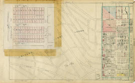
Part is a section depicting the area bounded by Imperial Street to English Bay to the University Endowment Lands to Fifth Avenue. The sheet has been extensively annotated, with colour coded areas to depict land use, status of lots as tax sale properties for sale, sewer and water lines, as well as other colour codes that are not noted on the legend at the front of the volume.

Point Grey section A supplementary information
Part of City of Vancouver fonds
Part is a sheet showing assessment and other information relevant to Point Grey section A.

Part of City of Vancouver fonds
Part is a section depicting the area bounded by Trutch Street to English Bay to Imperial Street to Fifth Avenue. The sheet has been extensively annotated, with colour coded areas to depict land use, status of lots as tax sale properties for sale, sewer and water lines, as well as other colour codes that are not noted on the legend at the front of the volume.

Point Grey section B supplementary information
Part of City of Vancouver fonds
Part is a sheet showing assessment and other information relevant to Point Grey section B.

Part of City of Vancouver fonds
Part is a section depicting the area bounded by Imperial Street to Fourth Avenue to the University Endowment Lands to Sixteenth Avenue. The sheet has been extensively annotated, with colour coded areas to depict land use, status of lots as tax sale properties for sale, sewer and water lines, as well as other colour codes that are not noted on the legend at the front of the volume.

Point Grey section C supplementary information
Part of City of Vancouver fonds
Part is a sheet showing assessment and other information relevant to Point Grey section C.

Part of City of Vancouver fonds
Part is a section depicting the area bounded by Trutch Street to Fourth Avenue to Imperial Street to Sixteenth Avenue. The sheet has been extensively annotated, with colour coded areas to depict land use, status of lots as tax sale properties for sale, sewer and water lines, as well as other colour codes that are not noted on the legend at the front of the volume.

Part of City of Vancouver fonds
Part is a section depicting the area bounded by Wallace Street to Sixteenth Avenue to the University Endowment Lands to Twenty-seventh Avenue. The sheet has been extensively annotated, with colour coded areas to depict land use, status of lots as tax sale properties for sale, sewer and water lines, as well as other colour codes that are not noted on the legend at the front of the volume.

Part of City of Vancouver fonds
Part is a section depicting the area bounded by Trafalgar Street to Sixteenth Avenue to Wallace Street to Twenty-seventh Avenue. The sheet has been extensively annotated, with colour coded areas to depict land use, status of lots as tax sale properties for sale, sewer and water lines, as well as other colour codes that are not noted on the legend at the front of the volume.

Point Grey section F supplementary information
Part of City of Vancouver fonds
Part is a sheet showing assessment and other information relevant to Point Grey section C. The sheet also includes a detail map of the area bounded by [Balaclava Street?] to 16th Avenue to Puget Drive to 19th Avenue

Part of City of Vancouver fonds
Part is a section depicting the area bounded by Granville Street to Sixteenth Avenue to Trafalgar Street to Twenty-eighth Avenue. The sheet has been extensively annotated, with colour coded areas to depict land use, status of lots as tax sale properties for sale, sewer and water lines, as well as other colour codes that are not noted on the legend at the front of the volume.

Point Grey section G supplementary information
Part of City of Vancouver fonds
Part is a sheet showing assessment and other information relevant to Point Grey section G.

Part of City of Vancouver fonds
Part is a section depicting the area bounded by Cambie Street to Sixteenth Avenue to Granville Street to Twenty-seventh Avenue. The sheet has been extensively annotated, with colour coded areas to depict land use, status of lots as tax sale properties for sale, sewer and water lines, as well as other colour codes that are not noted on the legend at the front of the volume.

Point Grey section H supplementary information
Part of City of Vancouver fonds
Part is a sheet showing assessment and other information relevant to Point Grey section H.
Part of City of Vancouver fonds
Part is a section depicting the area bounded by Wallace Street to Twenty-eighth Avenue to University Endowment Lands to Thirty-eighth Avenue. The sheet has been extensively annotated, with colour coded areas to depict land use, status of lots as tax sale properties for sale, sewer and water lines, as well as other colour codes that are not noted on the legend at the front of the volume. The left-hand side of the sheet has had an overlay applied which depicts revisions to the blocks bounded by Crown Street to 29th Avenue to Camosun Street to 31st Avenue.

Point Grey section J supplementary information
Part of City of Vancouver fonds
Part is a sheet with supplementary information in the form of a revised block plan for the are bounded by Crown Street to 27th Avenue to Camosun Street to 29th Avenue.

Part of City of Vancouver fonds
Part is a section depicting the area bounded by Trafalgar Street to Twenty-seventh Avenue to Wallace Street to Thirty-eighth Avenue. The sheet has been extensively annotated, with colour coded areas to depict land use, status of lots as tax sale properties for sale, sewer and water lines, as well as other colour codes that are not noted on the legend at the front of the volume.

Point Grey section K supplementary information
Part of City of Vancouver fonds
Part is a sheet showing assessment and other information relevant to Point Grey section K.

Part of City of Vancouver fonds
Part is a section depicting the area bounded by Granville Street to Nanton Avenue to Trafalgar Street to Thirty-eighth Avenue. The sheet has been extensively annotated, with colour coded areas to depict land use, status of lots as tax sale properties for sale, sewer and water lines, as well as other colour codes that are not noted on the legend at the front of the volume.

Point Grey section L supplementary information
Part of City of Vancouver fonds
Part is a sheet showing assessment and other information relevant to Point Grey section L.

Part of City of Vancouver fonds
Part is a section depicting the area bounded by Queen Elizabeth Park to Twenty-seventh Avenue to Granville Street to Thirty-eighth Avenue. The sheet has been extensively annotated, with colour coded areas to depict land use, status of lots as tax sale properties for sale, sewer and water lines, as well as other colour codes that are not noted on the legend at the front of the volume.

Part of City of Vancouver fonds
Part is a section depicting the area bounded by Wallace Street to Thirty-eighth Avenue to Musqueam Indian Reserve to Forty-ninth Avenue. The sheet has been extensively annotated, with colour coded areas to depict land use, status of lots as tax sale properties for sale, sewer and water lines, as well as other colour codes that are not noted on the legend at the front of the volume.
Point Grey section N supplementary information
Part of City of Vancouver fonds
Part is a sheet showing assessment and other information relevant to Point Grey section N.

Part of City of Vancouver fonds
Part is a section depicting the area bounded by Trafalgar Street to Thirty-eighth Avenue to Wallace Street to Forty-ninth Avenue. The sheet has been extensively annotated, with colour coded areas to depict land use, status of lots as tax sale properties for sale, sewer and water lines, as well as other colour codes that are not noted on the legend at the front of the volume.

Point Grey section O supplementary information
Part of City of Vancouver fonds
Part is a sheet showing assessment and other information relevant to Point Grey section O.

Part of City of Vancouver fonds
Part is a section depicting the area bounded by Granville Street to Thirty-seventh Avenue to Trafalgar Street to Forty-ninth Avenue. The sheet has been extensively annotated, with colour coded areas to depict land use, status of lots as tax sale properties for sale, sewer and water lines, as well as other colour codes that are not noted on the legend at the front of the volume.
Point Grey section P supplementary information
Part of City of Vancouver fonds
Part is a sheet showing assessment and other information relevant to Point Grey section P.

Part of City of Vancouver fonds
Part is a section depicting the area bounded by Cambie Street to Thirty-eighth Avenue to Granville Street to Forty-ninth Avenue. The sheet has been extensively annotated, with colour coded areas to depict land use, status of lots as tax sale properties for sale, sewer and water lines, as well as other colour codes that are not noted on the legend at the front of the volume.

Point Grey section Q supplementary information
Part of City of Vancouver fonds
Part is a sheet showing assessment and other information relevant to Point Grey section Q.

Part of City of Vancouver fonds
Part is a section depicting the area bounded by Marine Crescent to Forty-ninth Avenue to Wallace Street to the Fraser River. The sheet has been extensively annotated, with colour coded areas to depict land use, status of lots as tax sale properties for sale, sewer and water lines, as well as other colour codes that are not noted on the legend at the front of the volume.

Point Grey section S supplementary information
Part of City of Vancouver fonds
Part is a sheet showing assessment and other information relevant to Point Grey section S.

Part of City of Vancouver fonds
Part is a section depicting the area bounded by Granville Street to Forty-ninth Avenue to Marine Crescent to Sixty-first Avenue. The sheet has been extensively annotated, with colour coded areas to depict land use, status of lots as tax sale properties for sale, sewer and water lines, as well as other colour codes that are not noted on the legend at the front of the volume.

Point Grey section T supplementary information
Part of City of Vancouver fonds
Part is a sheet showing assessment and other information relevant to Point Grey section T. The sheet also includes an added overlay depicting revised block plans for the area bounded by Arbutus Street to 53rd Avenue to Beechwood Street to 57th Avenue.
Part of City of Vancouver fonds
Part is a section depicting the area bounded by Cambie Street to Forty-ninth Avenue to Granville Street to Sixtieth Avenue. The sheet has been extensively annotated, with colour coded areas to depict land use, status of lots as tax sale properties for sale, sewer and water lines, as well as other colour codes that are not noted on the legend at the front of the volume.

Point Grey section U supplementary information
Part of City of Vancouver fonds
Part is a sheet showing assessment and other information relevant to Point Grey section U. The sheet also includes an added overlay depicting revised block plans for the eastern half of the block bounded by Oak Street to 57th Avenue to Hudson Street to Fifty-eighth Avenue (Lot 10, Block 17A, D.L. 526).

Part of City of Vancouver fonds
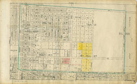
Part is a section depicting the area bounded by Granville Street to Sixtieth Avenue to the east boundary of D.L. 315 to the Fraser River/Seventy-first Avenue. The sheet has been extensively annotated, with colour coded areas to depict land use, status of lots as tax sale properties for sale, sewer and water lines, as well as other colour codes that are not noted on the legend at the front of the volume.

Point Grey section W supplementary information
Part of City of Vancouver fonds
Part is a sheet showing assessment and other information relevant to Point Grey section W. The sheet also includes an added overlay depicting revised block and street plan for the blocks bounded by West Boulevard to 66th Avenue to Angus Drive to Sixty-eighth Avenue (Block 17, D.L. 317).