Showing 241 results

Archival description
City of Vancouver Archives pamphlet collection With digital objects
Print preview View:

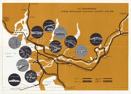
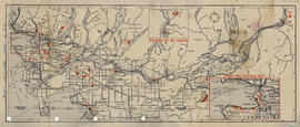
Civil Defence evacuation and survival plan for Greater Vancouver target area : side 2

Part contains inside of pamphlet cover with evacuation instructions and a map showing evacuation routes for Greater Vancouver. Map was created by Evergreen Press and added to by Vancouver Civil Defence. Evacuation routes are represented by colour coding and arrows accompanied by a legend on the top left corner of map. Map shows principal street names and extends from the Straight of Georgia to Lynn Valley Road to Brunette Road to Westminster Highway.

Kingsway-Boundary Industrial Centre to light industrial rail customers : Site Plan of Kingsway-Boundary Industrial Centre

Part contains a map showing the site plan for Kingsway-Boundary Industrial Centre. Map contains hand colored legend showing city owned property in orange, privately owned property in green and lanes in blue. Hand colored lots have been annotated by hand with numbers.

Kingsway-Boundary Industrial Centre to light industrial rail customers : side 1

Part contains a map showing location of Kingsway-Boundary Industrial Centre and information about the centre for light industrial rail customers. Map contains legend showing major arterial highways, highways under construction, main roads, and municipal and city boundaries. Map extends from Coquitlam to North Vancouver to University Endowment Lands to Westminster Highway.

Vancouver visitor's fun map : Visitors map of Greater Vancouver

Part contains a visitors map of Vancouver extending from the Straight of Georgia to Grouse Mountain to North Road to Deas Island Tunnel. Map legend shows signs for scenic drives, parks, fishing areas, totem poles, scenic views, pools and beaches, boat moorages, and highway route numbers. Part also contains an inset map showing an enlargement of Downtown Vancouver with twenty-seven tourist destinations located on the map.

Automobile road map of Vancouver Canada : side 1

Part contains textual information including points of interest, Canadian customs regulations, ferry timetables and rates. Part also contains two inset maps. A map of the Okanagan Circuit is in the top left corner, showing town names and a distance table with distances of towns from Vancouver in miles. A map showing ferry routes in the Gulf of Georgia is located in the middle of part.

Tourists' map of Greater Vancouver : map of Greater Vancouver and environs showing principal auto roads and highways

Part consists of a map of Greater Vancouver. Map extends from Howe Sound to Dome Mountain to Pitt River to Lulu Island. Map shows principal street names, golf and country clubs, bodies of water and city limits. Part contains textual information about parking regulations for the David Spencer store.

Results 151 to 200 of 241