Selected park programs for additional park sites 1959-1976
Plan of provincial government property to be sold at Victoria by public auction, Monday, January 18th, 1886
Advertisements for Vancouver real estate
The city of Vancouver, British Columbia
Schedule "A" : Polling districts : City of Vancouver
Schedule "A" : Polling districts : City of Vancouver
East Vancouver Heights
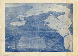
Bird's eye view of Vancouver, B.C.
Plan of Cambie St. grounds
Map of Greater Vancouver
What the man who comes to Vancouver wants to know
Redevelopment plan for Jericho Department of National Defence lands
Plan of re-subdivision of lots 3 to 14, subn [subdivision] 2 of bk [block] 3. D.L. 391 & 392
Plan showing polling divisions, City of Vancouver B.C., as defined in by-law no. 2434
Bus routes, city of Vancouver, November 26th 1937
Page from "The Buzzer," November 26, 1937, showing map of bus routes
Proposed Raymur Ave. [Avenue] Trunk Sewer diverting sewage from False Creek reclaimed area
Proposed Raymur Ave. [Avenue] Trunk Sewer diverting sewage from False Creek reclaimed area
Proposed Raymur Ave. [Avenue] Trunk Sewer diverting sewage from False Creek reclaimed area
B.C. Electric plan showing bus stops in Vancouver
Champlain Heights : D.L. 334, group one, N.W.D.
City of Vancouver : residential lots, Area B, Champlain Heights : page 1
City of Vancouver : residential lots, Area B, Champlain Heights : page 2
Vancouver, British Columbia : northerly portion, former City of Vancouver : major street plan
Vancouver, British Columbia, south-easterly portion, formerly South Vancouver : major street plan
Vancouver, British Columbia : south-westerly portion, formerly Point Grey : major street plan
Metropolitan Vancouver
City of Vancouver, British Columbia : co-ordinate street index map 12
[Map of Pioneer Place showing the area deeded to the City of Vancouver by the C.P.R.]
Vancouver parks
Rezoning application map (Point Grey Road)
Greater Vancouver votes October 17th : know your ward - know your poll
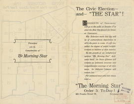
The civic election - and "The Star"!
Greater Vancouver votes October 17th : know your ward - know your poll
The civic election - and "The Star"!
Plan of Point Grey Municipality
B.C. Electric Rly. Co. Ltd. plan showing transit services in Vancouver city as at end of 1951
B.C. Electric Rly. Co. Ltd. plan showing transit services in Vancouver city as at end of 1951 : verso with annotations
British Columbia Electric Railway Company Limited : Vancouver and New Westminster city and suburban lines and Alouette-Stave development, present and projected
B.C. Electric guide to Greater Vancouver : Richmond transit system, downtown Vancouver transit system, street index, and general information
Dial map of Greater Vancouver
Dial map of Greater Vancouver and suburbs
Dial map of Greater Vancouver and suburbs
Indexed map of Greater Vancouver showing distances from Bekins building
Indexed map of Greater Vancouver : map cover and advertisements
Free map of Vancouver, New Westminster and surroundings
Plan of the City of Vancouver. Western Terminus of the Canadian Pacific Railway
Plan no. 2 : showing city distribution system, pressure districts, fire stations and water flow test locations : City of Vancouver, British Columbia


![Plan of re-subdivision of lots 3 to 14, subn [subdivision] 2 of bk [block] 3. D.L. 391 & 392](/uploads/r/null/4/a/4a0ea6aa076433c7bcad0c847f7acb3bb1046f7abf2801c48b97d9ca58f49a73/9bd508e4-c85e-4090-b266-27571c5d4dbc-MAP754_142.jpg)


![Proposed Raymur Ave. [Avenue] Trunk Sewer diverting sewage from False Creek reclaimed area](/uploads/r/null/c/d/cddf61ac60b97b6fc54309ecbf8d1aea8e9aac3c672576fbd9953a05b82d42fc/14951fa4-0fd0-480c-a1f3-b7c2ef158398-MAP761_142.jpg)
![Proposed Raymur Ave. [Avenue] Trunk Sewer diverting sewage from False Creek reclaimed area](/uploads/r/null/5/2/5260099e92441f23442086ea3a8b5f7512bb5b4b4b5cbf554c9f13450bf4d37f/b5165f5d-bd82-46b5-9beb-0f969f7755ef-MAP761_142.jpg)
![Proposed Raymur Ave. [Avenue] Trunk Sewer diverting sewage from False Creek reclaimed area](/uploads/r/null/a/8/a8edd70876832fb32ffa8add8b5e261fe78b0e6efcb26d07a6fe1c74bf545b57/ac62eada-955d-4eee-8508-6bf4b71a21e5-MAP761_142.jpg)


![[Map of Pioneer Place showing the area deeded to the City of Vancouver by the C.P.R.]](/uploads/r/null/4/1/41ba387b96586eb8554abcbf013c0e5cfbb116a42c8d1d1d2311fb1856694b2a/e3bd79d3-cd72-42e4-aa51-bc080514c205-MAP780_142.jpg)