Showing 1505 results

Archival description
City of Vancouver Archives technical and cartographic drawing collection Item
Print preview View:

1194 results with digital objects Show results with digital objects

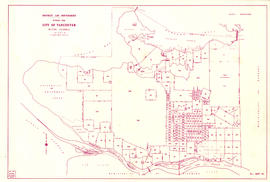
Commercial Map of Greater Vancouver and District [BC]

The map shows the Greater Vancouver district, Point Grey, West Vancouver, North Vancouver, South Vancouver, and Burnaby - in 1886. In correspondence, the legend and map display railroads, paved streets, schools, and buildings. Uniquely, the map shows the city divided by Postal Block numbers and half mile circles that radiate from City Hall on the corner of Main and Hastings. The Westernmost road on the map is Marine Drive and the easternmost is Columbia Street. Northernmost road on the map is Dempsey Street, and the Southernmost point is No. 20 Road.

A detailed compass, in the bottom left hand corner of the map, shows Magnetic North. The annotation M.49 appears in the bottom right hand corner and the top left hand corner of the map. Two copies of the map are available, one a blue line the other a linen copy.

Commercial map of Greater Vancouver and district [planning]

Item is a printed map of greater Vancouver which has been used as a base map. The base map appears to be the 1929 version of the Commercial Map of Greater Vancouver and District. On this has been added pasted on pictures, arrows and other material that appears to be related to planning activities of some kind.

Composite aerial photographic map of the greater Vancouver area

Item is a map made up of a collage of aerial photogrpahs showing the greater Vancouver area bounded approximately by the North Shore Mountains in the north, the Gulf of Georgia in the west, the Burnaby-Coquitlam border in the east, and the Fraser River and parts of Surrey and Lulu Island (Richmond) in the south. Neither the photograph or who was responsible for the composite is identified.

Composite industrial map of the metropolitan area, Lower Mainland, British Columbia

Item is a map showing areas either occupied by industry or zoned for industry in the following municipalities of the Lower Mainland: Vancouver, New Westminster, North Vancouver, Port Coquitlam, Port Moody, Burnaby, Coquitlam, Delta, North Vancouver, Richmond, Surrey and West Vancouver. Industrial areas are categorized as either light or heavy industry. New housing developments, main traffic arteries, railways and municipal boundaries are also indicated.

Contour map showing surveyed lots, notes on vegetation and routes traveled on mountaineering expeditions

Item is a copy of a topographical map with annotations regarding logged areas around the northern end of Jervis Inlet and Princess Louisa Inlet. This copy has been used as a base map to shows climbing routes traveled to the summits of Albert Mountain, Mount Tinniswood, Mount George Edwards, Mount Alexander, Mount Victoria and Mount Alfred on expeditions between 1929 and 1941. The photograph shows A. T. Dalton standing on Matthews Glacier overlooking Dawn Glacier, Mount Tinniswood, Duane Peak, Mount Casement and Mount Albert.

The annotations add topography to areas blank on the base map, as well as indicating climbing routes, dates, and notes on geography and topograhy. The annotations are attested and dated by A.T. Dalton.

Coquitlam

Item is a map showing topography, roads, trails, railways, bridges, boundaries, reserves, power lines, telephone lines, triangulation stations, camera stations, bench marks, houses, barns, mills, factories, schools, churches, post offices, telephone exchanges, mines and geographic features in the Pitt Lake area, including Coquitlam Mountain, Mount Blanshard, and Siwash Island. A small index map shows the area covered by the primary map in relation to other maps in the series.

Coquitlam

Item is a map showing topography, roads, trails, railways, bridges, boundaries, reserves, power lines, telephone lines, triangulation stations, camera stations, bench marks, houses, barns, mills, factories, schools, churches, post offices, telephone exchanges, mines and geographic features in the area of Indian Arm and Coquitlam Lake, extending south to Port Moody, Port Coquitlam, and the northeast part of Burnaby. A small index map shows the area covered by the primary map in relation to other maps in the series.

Corporation of Point Grey : topographical plan of ABCDE D.L. 317 and HIJK D.L. 318 : Marine Drive & Vancouver & Lulu Railway to Fraser River between Angus St. [Drive] & Milton St

Item is a topographical plan of Point Grey showing the area from Angus Drive to Granville Street and 71st Avenue to the Fraser River, including property in D.L. 317 and D.L. 318. Plan shows the locations of the Vancouver and Lulu Island Railway, as well as ponds, dams, barns, houses and offices.

Development in the western portion of the Lower Mainland region, 1968

Item is a map showing residential, commercial, industrial, civic and institutional, parks and recreational and agricultural zoning in the Lower Mainland area, including West Vancouver, North Vancouver, Vancouver, Burnaby, Coquitlam, New Westminster, Richmond, Maple Ridge, Langley, Surrey, Delta and White Rock. Information has been added to a base map published by the Province of British Columbia.

Devonshire Block 41

Item consists of a map similar to a planning map of the central downtown business district, showing the principal buildings and either their heights or total elevations. This may have been created as part of the development application for the Bank of British Columbia Building (now HBSC Bank Building) at 855 West Georgia Street, which was built at the site of the demolished Devonshire Hotel in 1987.

[False Creek basin]

Item is a map of the False Creek basin and surrounding areas, from Granville Street north of False Creek and Fir Street to the west, Main Street to the east, Davie Street to the north and West 6th Avenue to the south. The map notes legal and descriptions of properties in the area depicted.

Vancouver (B.C.). Engineering Services

Results 151 to 200 of 1505