
Goat Mountain from clearing on Grouse Mountain
- AM76-F02-: CVA 369-68
- Item
- [1925?]
1645 results with digital objects Show results with digital objects
Goat Mountain from clearing on Grouse Mountain

The Pyramid and the Camel from Crown Pass

The Camel from Grouse Mountain

Goat Mountain from Grouse Mountain

Grouse Mountain Highway from Thunderbird Bridge
Photograph shows 2 men and a tractor on bridge.

Bill McGuigan and two friends at Grouse Mountain
Part of McGuigan family fonds

Bill McGuigan and three friends at Grouse Mountain
Part of McGuigan family fonds

Part of McGuigan family fonds
Photograph shows 4 young men picnicking.

60 inch to 90 inch Y. at Seymour Falls Dam construction site
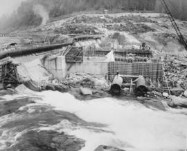
General view of Seymour Falls Dam construction of the looking east from old screen room
Photograph shows part of west diversion breach on extreme left. Formwork is cut off wall between buttresses 9 and 10 to between buttress 10 and 11. In left background is part of 60 inch main from temporary pumping station.
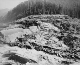
View from axis of old Seymour Falls Dam showing intake structure and form work for transitions

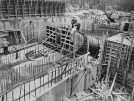
View of construction of Seymour Falls Dam looking north between buttresses 11 to 14
Photograph shows intake structure located between buttresses 12 and 13; and buttress 11 and 14 have been completed to E1 765.5 and buttresses 12 and 13 have been completed to E1 741.5 feet.

Two 78 inch diameter conduits being prepared for concrete encasement for Seymour Falls Dam
![The Camel [mountain]](/uploads/r/null/9/b/b/9bb35b17db4119b2907667aca290d8f3cad4d1ad72814e7b9f9307da7306a277/661cd1ac-0d60-4ccf-984f-367975aade01-1994-025_142.jpg)
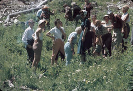
Van Nat Hist outing to Mt. Seymour

Target practice in the woods off Indian River Road, North Vancouver; Greenwood Archers

Posed photo of the women archers (Greenwood Archers) in forest off Indian River Road


![[Capilano family grave]](/uploads/r/null/5/c/e/5cef4251fa186194966f5392fc9b975809a4f967280530259088f687bf026827/d6d17021-8850-41b6-95cd-aedd3c3ced41-CVA371-124_142.jpg)
Part of Major Matthews collection

Part of City of Vancouver Archives technical and cartographic drawing collection
Map shows Vancouver from West Boulevard to Boundary Road and from Burrard Inlet to the Fraser River. A portion of North Vancouver is also shown. Streets, parks, schools and golf courses are identified. Map joins with MAP 575 to create a complete map of the City of Vancouver.


Suspension Bridge : First Capilano Canyon : Vancouver, B.C. : Length 450 feet

Capilano River : Vancouver, B.C.

Pergola and Gate House : Suspension Bridge : First Capilano Canyon : Vancouver, B.C.

Suspension Bridge : First Capilano Canyon : Vancouver, B.C. : Length 450 feet : Height 200 feet

Capilano Creek and Suspension Bridge


Capilano River and Suspension Bridge


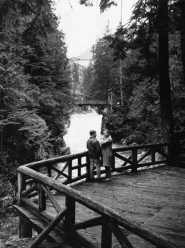
Couple at Capilano Canyon Park
Dial map of the city of Vancouver including the adjacent municipalities
Item is a street map showing Vancouver, Burnaby, New Westminster, West Vancouver and North Vancouver on one side and the University Endowment Lands, Surrey, Maillardville, Lulu Island and Sea Island on the other.
Item is a street map showing Vancouver, Burnaby, New Westminster, West Vancouver, and North Vancouver on one side and Lulu Island and Sea Island, Delta, Surrey, Langley and Maillardville on the other.

Dial map of Greater Vancouver and suburbs
Part contains a street map of Vancouver, Burnaby, New Westminster, West Vancouver and North Vancouver showing block numbers, street car, bus, and railway lines, parks and hospitals. Map includes two dials (a numbered circle, a paper indicator, a grid of block numbers and a street index used to find locations). A small inset map shows the Capitol Hill/Scenic Park area of Burnaby in greater detail.

Photograph shows people crossing the suspension bridge
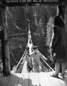
Photograph shows people crossing the suspension bridge

Photograph shows "The Old Indian Wishing Well of Capilano" and two wooden figures of First Nations people.

![Odds & ends: Goldheart 1948, 865 Wildwood 1979, K[nox] Lake 1979, people W[est] Van show 1950...](/uploads/r/null/8/9/8/89881bb7d38c9bd09c3053d8a085de9ba399d8453f52ac814d182d2a9fdd94f3/98f19cd8-b6a3-41bb-ad67-d2e7c360b837-2011-016_142.jpg)
Part of George Thompson fonds
Item is a film consisting of at least seven separate pieces of amateur film footage spliced together. Film includes black and white footage taken at Grouse Mountain in 1930 showing men and women skiing, a snowplough clearing snow, a dogsled, and a black bear cub playing with a dog. The remaining film footage is in colour, and includes George Thompson jumping obstacles on horseback in 1947; 1948 footage of the Thompson's champion horse Goldheart and two men riding in a chariot pulled by Goldheart and another horse; a large number of spectators sitting in stands to watch an unidentified event in West Vancouver in 1950; cabins and horses at Knox Lake in 1979; and the Thompson's house and gardens at 865 Wildwood Lane, West Vancouver in 1979 and 1980.

Northshore Terminal Railway - Vancouver Harbour
Part of Samuel S. Magoffin fonds
Item is an amateur film showing the work of the S.S. Magoffin & Co. Limited Railway Contractors company, likely during construction of the North Shore Terminal Railway in North Vancouver. Activities documented include the blasting and clearing of soil and rock by work crews and steam shovels, locomotives transporting soil and rock, and railway cars dumping the soil. Also included is footage of a barge used to transport a steam shovel and locomotive, and the offloading of the steam shovel from the barge. The film also shows the clearing of land with a brush fire and men using hoses to control the fire, as well as men working on the track. There are several shots of unidentified individuals, possibly including Vancouver Harbour Commissioners, throughout the film; Sam Magoffin appears briefly with three other men at 15:56 (third from the left). The film finishes with a shot of locomotives moving soil, with the Vancouver skyline in the background.
![Vancouver Harbour Northshore Terminal [Railway]](/uploads/r/null/9/a/7/9a7890ab06be1a52eb339901058f5db1412b949cad2031bb0cdd2fc57e49d7d1/b0e27bc5-4f01-4914-938c-0be14afb3aff-2011-002_142.jpg)
Vancouver Harbour Northshore Terminal [Railway]
Part of Samuel S. Magoffin fonds
Item is an amateur film showing the work of the S.S. Magoffin & Co. Limited Railway Contractors company during construction of the North Shore Terminal Railway in North Vancouver. Activities documented include the blasting and clearing of soil and rock with steam shovels, railway cars transporting and dumping soil over a trestle and men sawing railway ties. Includes many scenes of workers and other individuals, possibly including Vancouver Harbour Commissioners, footage of land owned by the B.C. Mills Timber and Trading Company Limited.

Part of Samuel S. Magoffin fonds
Item is an amateur film showing people with dogs in the snow and Sam and Margaret Magoffin with her parents, the Boalts, having a picnic in the woods, at the Capilano Suspension Bridge, and then at the beach where the men change a tire on the car. Also included in the film are scenes taken at home with the women knitting and sewing, Margaret and her parents exiting the Devonshire Hotel and entering a car with the courthouse in the background, people waving from the back of a train, and Sam and Margaret standing by a window.
![Seens [scenes] of Van[couver], Capilano, Stanley Park](/uploads/r/null/1/3/b/13bc9013786c37378f12ed8a438df461807fab1a389b9e9c2896f171e1c9e03f/b640bf28-47ef-404b-9944-eeb4bd5eeda9-2012-033_142.jpg)
Seens [scenes] of Van[couver], Capilano, Stanley Park
Part of City of Vancouver Archives sound recording and moving image collection
Item is a film showing various scenes around Vancouver. The first half of this film documents a Gray Line Tours bus trip through Vancouver and second half contains scenes showing landmarks of Vancouver and surrounding areas. Film contains footage showing: Empress of Japan Figurehead in Stanley Park, U.B.C., Chinatown, Hotel Georgia, Lion's Gate Bridge, Court House, Capilano Suspension Bridge, Capilano Golf and Country Club, Prospect Point, Stanley Park, views of downtown and North Shore Mountains from Little Mountain, City Hall, sailboats in Burrard Inlet, and Swimmers at Kits Beach.
Horse races and Shetland Ponies, Virginia and Family
Part of City of Vancouver Archives sound recording and moving image collection
Item is a film containing footage of a pageant, people riding horses and ponies, the Capilano Suspension Bridge and surrounding area, the Capilano River valley and surrounding trails, orchestra at Malkin Bowl, a picnic, children playing in backyard and wading pool (possibly at 3846 West 10th), May Day Parade in downtown Vancouver, Stanley Park gardens, George Vancouver statue and City Hall campus, Vancouver skyline view from City Hall and children playing in grassy area.