
View of Hollyburn Ridge from Grouse Mountain
- AM76-F02-: CVA 369-55
- Item
- [1925?]
1620 results with digital objects Show results with digital objects
View of Hollyburn Ridge from Grouse Mountain
View of the Lions from Grouse Mountain

Vancouver from Grouse Mountain at night

Vancouver from Grouse Mountain

Overlooking Vancouver towards Grouse Mountain

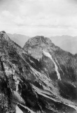
Mountain tops surrounding Grouse Mountain

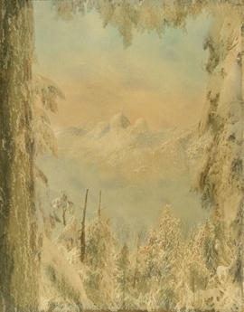
Pyramid and Camel Mountains from Crown Pass

Photograph shows a man on top of a peak.


Crown Ridge, Grouse Mountain Park

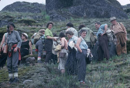
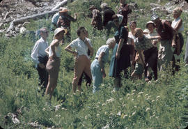
Photograph shows 6 hikers in clearing.

Goat Mountain from clearing on Grouse Mountain

The Pyramid and the Camel from Crown Pass

The Camel from Grouse Mountain

Goat Mountain from Grouse Mountain

Grouse Mountain Highway from Thunderbird Bridge
Photograph shows 2 men and a tractor on bridge.

Bill McGuigan and two friends at Grouse Mountain
Part of McGuigan family fonds

Bill McGuigan and three friends at Grouse Mountain
Part of McGuigan family fonds

Part of McGuigan family fonds
Photograph shows 4 young men picnicking.

60 inch to 90 inch Y. at Seymour Falls Dam construction site
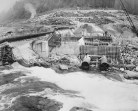
General view of Seymour Falls Dam construction of the looking east from old screen room
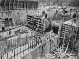
Photograph shows part of west diversion breach on extreme left. Formwork is cut off wall between buttresses 9 and 10 to between buttress 10 and 11. In left background is part of 60 inch main from temporary pumping station.
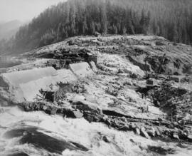
View from axis of old Seymour Falls Dam showing intake structure and form work for transitions

View of construction of Seymour Falls Dam looking north between buttresses 11 to 14
Photograph shows intake structure located between buttresses 12 and 13; and buttress 11 and 14 have been completed to E1 765.5 and buttresses 12 and 13 have been completed to E1 741.5 feet.

Two 78 inch diameter conduits being prepared for concrete encasement for Seymour Falls Dam
![The Camel [mountain]](/uploads/r/null/9/b/b/9bb35b17db4119b2907667aca290d8f3cad4d1ad72814e7b9f9307da7306a277/661cd1ac-0d60-4ccf-984f-367975aade01-1994-025_142.jpg)
Van Nat Hist outing to Mt. Seymour

Target practice in the woods off Indian River Road, North Vancouver; Greenwood Archers

Posed photo of the women archers (Greenwood Archers) in forest off Indian River Road


![[Capilano family grave]](/uploads/r/null/5/c/e/5cef4251fa186194966f5392fc9b975809a4f967280530259088f687bf026827/d6d17021-8850-41b6-95cd-aedd3c3ced41-CVA371-124_142.jpg)
Part of Major Matthews collection

Part of City of Vancouver Archives technical and cartographic drawing collection
Map shows Vancouver from West Boulevard to Boundary Road and from Burrard Inlet to the Fraser River. A portion of North Vancouver is also shown. Streets, parks, schools and golf courses are identified. Map joins with MAP 575 to create a complete map of the City of Vancouver.


Suspension Bridge : First Capilano Canyon : Vancouver, B.C. : Length 450 feet

Capilano River : Vancouver, B.C.

Pergola and Gate House : Suspension Bridge : First Capilano Canyon : Vancouver, B.C.

Suspension Bridge : First Capilano Canyon : Vancouver, B.C. : Length 450 feet : Height 200 feet

Capilano Creek and Suspension Bridge


Capilano River and Suspension Bridge


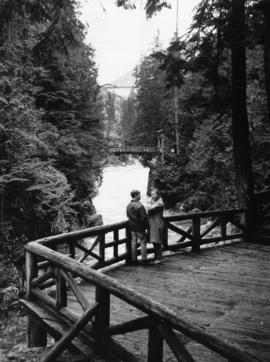
Couple at Capilano Canyon Park
Dial map of the city of Vancouver including the adjacent municipalities
Item is a street map showing Vancouver, Burnaby, New Westminster, West Vancouver and North Vancouver on one side and the University Endowment Lands, Surrey, Maillardville, Lulu Island and Sea Island on the other.
Item is a street map showing Vancouver, Burnaby, New Westminster, West Vancouver, and North Vancouver on one side and Lulu Island and Sea Island, Delta, Surrey, Langley and Maillardville on the other.