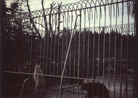
Stanley Park, bear cage with two polar bears and two grizzly bears
- AM1376-: CVA 72-50
- Item
- [between 1950 and 1952]
1492 results with digital objects Show results with digital objects
Stanley Park, bear cage with two polar bears and two grizzly bears
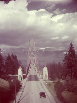
Stanley Park, Lions Gate Bridge southern approach
Item is a photograph of the southern approach to the Lion's Gate Bridge from Stanley Park. Looking north across the bridge, the road, decorative lions and pylons, and cables and piers are visible.

Japanese cherry trees, Stanley Park; 1950
Item is a photograph of Japanese cherry trees in bloom around the Japanese Memorial in Stanley Park.
![Wilson [Harding] memorial, Stanley Park](/uploads/r/null/6/8/e/68e3a71452408ba9791fc140e1befcb53d79722b0251cbd86632949a37835c0c/77c422b7-125a-44e2-8a8b-9850a21f7699-CVA72-53_142.jpg)
Wilson [Harding] memorial, Stanley Park
Item is a photograph of the Warren G. Harding Memorial in Stanley Park.

C.N. Dock, with ships and barges
![[View looking north from Granville Street and 14th Avenue]](/uploads/r/null/d/6/d69db2c2bb4b88fa530d16ebe363cdc169c4295d1b2970a2b748f72ca47a2b61/4074e348-0383-47fb-962c-715c80f990e4-A63891_142.jpg)
[View looking north from Granville Street and 14th Avenue]
Panoramic view showing part of Kitsilano, Fir Street, Fairview and the Kitsilano Trestle Bridge, the West End and Downtown in the background
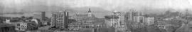
Panoramic view from approximately Pender Street and Granville Street looking north showing the Orpheum Theatre at 805 West Pender Street, the top of the Post Office building and clock tower, the Canadian Imperial Bank of Commerce and the Dominion Building, the World Building (Sun Tower) and Burrard Inlet in the background

Philip T. Timms near his 94th birthday
Item is a photograph portrait of Philip T. Timms behind the counter of his printing shop.

Philip T. Timms at printing press, near his 94th birthday
Item is a photograph portrait of Philip T. Timms at a printing press, holding a freshly printed sign.

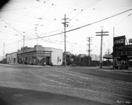
Kingsway at Commercial, post improvements
Item is a photograph of intersection of Kingsway and Commercial, looking south-east, after the Kingsway improvements. The identified establishments in the photograph are Kingsway Drug Co. Ltd, Fletcher's Meats Co. (Fletcher's No 1 Bacon on sign), and Scott's Home Bakery.

Kingsway at Beatrice, pre improvements
Item is a photograph of Kingsway at Beatrice, looking southeast, before the Kingsway improvements. Identified establishments visible in the photograph include Kingsway Woodworks, Steele and Co., and the Tyrell Block.

Kingsway at Beatrice, post improvements
Item is a photograph of Kingsway at Beatrice, looking southeast, after the Kingsway improvements. Identified establishments visible in the photograph include Kingsway Woodworks, Geo. Collett Boot & Shoe Hospital, Steele and Co., and the Tyrell Block.

Kingsway at Victoria Drive, southeast, pre improvements
Item is a photograph of the intersection of Kingsway and Victoria Drive, looking southeast, before the Kingsway improvements. Identified establishments on the southeast corner include W. H. A. Van Alstine Drugs, George Collett Boot and Shoe Hospital (before its move to the 1900 block of Kingsway), Maple Leaf Barber Shop, and Bell's Grocery. Across Kingsway in the right of the photograph is Star Grocery. There is a billboard for Turret Cigarettes across the intersection on Victoria.

Kingsway at Victoria Drive, southwest, pre improvements
Item is a photograph of the intersection of Kingsway and Victoria Drive, looking southwest, before the Kingsway improvements. W. H. A. Van Alstine Drugs can be seen across Kingsway on the southeast corner of the intersection, on the southeast corner of the intersection Star Grocery, White Produce, and W. S. Parcells real estate can be seen. Advertisements for Coca-Cola, Toronto Dominion Trusts, and Seal Brand coffee are visible on the grocery store building.
Kingsway at Victoria Drive, southeast, post improvements
Item is a photograph of the intersection of Kingsway and Victoria Drive, looking southeast, after the Kingsway improvements. Identified establishments on the southeast corner include the empty W. H. A. Van Alstine Drugs location (the old sign is visible behind the building) and Maple Leaf Barber Shop. There is a billboard for Shell Gasoline across the intersection further along Victoria. New utility poles, street light, and sidewalks care visible in the photograph, and the buildings have been renovated to accommodate the widened street.

Kingsway at Victoria Drive, southwest, post improvements
Item is a photograph of the intersection of Kingsway and Victoria Drive, looking southwest, after the Kingsway improvements. The corner of the empty W. H. A. Van Alstine Drugs location can be seen across Kingsway on the southeast corner of the intersection, on the southeast corner of the intersection an unidentified grocery store and W. S. Parcells real estate can be seen. Advertisements for Coca-Cola and Turret Cigarettes are visible on the grocery store building.

Kingsway at Commercial, pre improvements
Item is a photograph of intersection of Kingsway and Commercial, looking south-east, before the Kingsway improvements. The identified establishments in the photograph are Kingsway Drug Co. Ltd, Fletcher's Meats Co. (Fletcher's No 1 Bacon on sign), and Scott's Home Bakery.

Kingsway at Knight Street, southwest corner, pre improvements
Item is a photograph of Kingsway at Knight Street, southwest corner, looking east, before the Kingsway improvements. The photograph shows the sidewalk in front of Herbert Eldridge Drugs and the fence and sidewalk sections across Knight Street that would be soon renovated.

Kingsway at Knight Street, southwest corner, post improvements
Item is a photograph of Kingsway at Knight Street, southwest corner, looking east, after the Kingsway improvements. The photograph shows the new sidewalk in front of Herbert Eldridge Drugs, the widened section of Kingsway, and the fully renovated fence and sidewalk sections across Knight Street. New billboards on Knight Street have advertisements for Forst's Radio (selling Philco radios) and City Coal Co.

Kingsway at Knight Street, southeast corner, pre improvements
Item is a photograph of the intersection of Kingsway and Knight Street, looking at the southeast corner, before the Kingsway improvements. The photograph shows the street, fence and sidewalk sections at the intersection that would be soon renovated.
Kingsway at Knight Street, southeast corner, post improvements
Item is a photograph of the intersection of Kingsway and Knight Street, looking at the southeast corner, after the Kingsway improvements. The photograph shows the widened section of Kingsway and the fully renovated fence and sidewalk sections across Knight Street. New billboards on Knight Street have advertisements for Forst's Radio (selling Philco radios) and City Coal Co.

Kingsway at Perry Street, Jones Tent and Awning Co. Ltd., pre improvements
Item is a photograph of Kingsway at Perry Street, looking northwest at the Jones & Son Tent and Awning Co. Ltd. Building. This photograph was taken before the building was shortened to make room for street widening and other improvements.
Kingsway at Perry Street, Jones Tent and Awning Co. Ltd., post improvements
Item is a photograph of Kingsway at Perry Street, looking northwest at the Jones & Son Tent and Awning Co. Ltd. Building. This photograph was taken after the Kingsway expansion and other new street improvements had taken place. The building has been shortened on front, with a new facade, and expanded on the back.

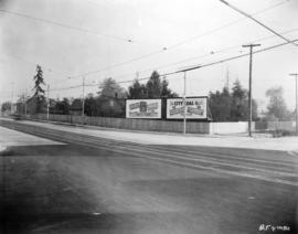
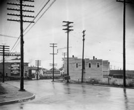
Kingsway at Commercial Drive, Natal Garage, pre improvement
Item is a photograph of Kingsway at Commercial Drive looking west at the southwest corner of the intersection, before the Kingsway improvements. The photograph shows a small corner store, the Natal Garage and service station, and a building under construction. Coca-Cola and Orange Crush signs are on the side of the corner store, and a delivery truck for Fletcher's No. 1 Bacon is at the service station.
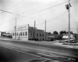
Kingsway at Commercial Drive, Natal Garage, post improvement
Item is a photograph of Kingsway at Commercial Drive looking west at the southwest corner of the intersection, after the Kingsway improvements. The photograph shows the Natal Garage and service station and a convince store. Coca-Cola and Orange Crush signs are on the side of the convenience store. The new sidewalks, utility poles with street lamps, and the newly expanded road are all visible.

Kingsway between Knight and Dumfries, looking northwest
Item is a photograph of Kingsway, between Knight Street and Dumfries Street, looking northwest. The awnings and partial storefronts of Stella Mae's Dressmaking and Ed's Fish & Chips are visible along the sidewalk leading up to Knight Street on the right. Diagonally across the Kingsway and Knight Street intersection several local businesses can be seen, including the Wayside Barber Shop, Sun Chong & Co., and Flemons.

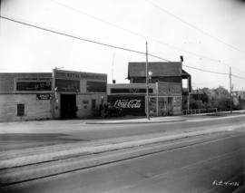
Kingsway at Knight, Ed's Fish & Chips
Item is a photograph of the intersection of Kingsway and Knight Street, looking southeast. The building on the corner is Ed's Fish & Chips.
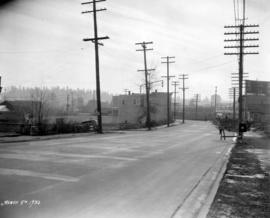
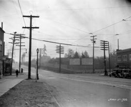
Kingsway between Tyne and Battison Streets, looking west
Item is a photograph of road construction on Kingsway, between Tyne Street and Battison Street, looking west. The photograph shows a man holding a flag, mostly obscured by a warning sign, and B.C. Telephone Company workers work at the base of a utility pole. The building in the centre of the photograph has "The Bungalow" written on the side.
Kingsway at Knight, looking southeast at intersection
Item is a photograph of the intersection of Kingsway and Knight Street, looking southeast, during the Kingsway improvements. On the left edge the signage for Ideal Fish & Chips can be seen, and on the corner across Knight is Ed's Fish & Chips. The newly constructed fence and billboards are visible at the southeast corner of the intersection in the upper right corner, but the road widening and other improvements have not been completed.
Kingsway between Tyne and Battison Streets, looking east
Item is a photograph of Kingsway, between Tyne Street and Battison Street, looking east. B.C. Telephone Co. equipment is visible at the construction site in the middle of the photograph. Advertisement billboards for The Seaton apartments and the Alcazar Hotel (Hotel Alcazar on the billboard) are visible. The building in the centre right of the photograph has "The Bungalow" written on the side.

Kingsway between Tyne and Battison Streets, looking west, construction
Item is a photograph of road construction on Kingsway, between Tyne Street and Battison Street, looking west. The photograph shows a man holding a flag and two B.C. Telephone Company workers work at the base of a utility pole. The building in the centre left of the photograph has "The Bungalow" written on the side.

Vancouver City Council Chambers, Mayor Fred Hume incumbent mayor
Item is a photograph of the Vancouver City Council Chambers, including Mayor Fred Hume incumbent mayor, councilors and guests.
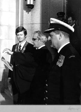
City officials on the steps of City Hall
Item is a photograph showing the ceremony for the HMCS Discovery reserve unit awarded the Freedom of the City honour with Mayor Art Phillips (front left), City Clerk Doug Little (centre), naval officer Commander Jack Thornton (front right) as well as Chief Constable John Fisk and Alderman Harry Rankin (back).
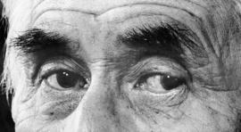
Item is a panorama photograph of a close-up of the eyes of Chief Dan George.

Six-inch gun crew, 1914, Stanley Park, Vancouver
Item is a group photograph of the six-inch gun crew detachment (guns manned by R.C.N.V.R. personnel) in Stanley Park. [One identified individual in the photograph is Sam Collins, fifth from right.]

Warren G. Harding memorial, Stanley Park
![[Warren G. Harding memorial with lily pond in foreground]](/uploads/r/null/4/f/3/4f3aecd70f731a1e81e08e440006c44a830d07a8f0806c92b4a653da39438080/92211088-65a2-4d37-b05a-8fbf5e25a600-CVA8-02_142.jpg)
[Warren G. Harding memorial with lily pond in foreground]

![[Stanley Park forest in snow]](/uploads/r/null/9/0/3/9032d96b4cdc1884199a8e47e438b84597adb7544515442327077a36460f8a81/0e98491f-a03c-4f40-9a74-e9bd01d113af-CVA8-04_142.jpg)

Looking east on Hastings Street from Homer Street showing sidewalks filled with people
Photograph shows businesses on the north side of the 300 Block of Hastings Street and the Dominion Trust Building

"The Geisha". Vancouver Operatic Society, Avenue Theatre, May 15, 16, 17, 19.
![[Cast of "The Geisha" on stage showing interior of the Avenue Theatre]](/uploads/r/null/9/d/4/9d403a6b587ec8ed0381c197fc99632cdba032b149a4d8ccf7023c215ce34d17/b6075f05-02c5-46a2-8db1-6c7c58db1661-CVA8-08_142.jpg)
[Cast of "The Geisha" on stage showing interior of the Avenue Theatre]

"The Lions" from Capilano Road

Suspension bridge taken from Capilano Creek

Suspension bridge taken from Capilano Creek

![[Group photo of pioneer W.A. Boult family]](/uploads/r/null/7/f/8/7f850128431b58017acefffaef4fe1b1a134351316943ce0e82c3bfe1316c0b0/decaf87a-e924-40ad-a46c-f53c8e3bcb79-CVA8-17_142.jpg)
[Group photo of pioneer W.A. Boult family]
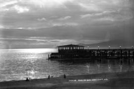
English Bay pier at evening, Vancouver, B.C.

Sunset, from Point Grey, Vancouver, B.C.
![[Stanley Park duck pond and fountain]](/uploads/r/null/9/5/b/95b6cceb71a61afc879888056f5d97c0d71a7c6f09221f6c308fa2d9bd537f68/5674aefb-455d-4552-aeae-0dee9a52c7e0-CVA8-26_142.jpg)
[Stanley Park duck pond and fountain]