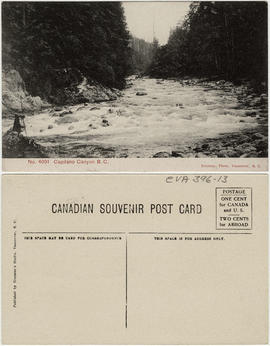
![Capilano [Creek] looking upstream from north part of island](/uploads/r/null/a/8/a896dc9c2db3c65159f7e2771c98e330ea3c12b91907157c4698e756dbb1826c/b3e6f5a4-4ff6-456c-84bb-263e82325018-A16531_142.jpg)
Capilano [Creek] looking upstream from north part of island
- COV-S632-: CVA 789-30
- Item
- Aug. 4, 1915
Part of City of Vancouver fonds
Capilano [Creek] looking upstream from north part of island
Part of City of Vancouver fonds
![Capilano [Creek] beneath [retaining?] wall at south end, looking eastward](/uploads/r/null/8/2/82c3a40e01fe7a1d90487e7f21e0c3205a6f0dac00ec239d9734f1d0950e13f3/6cfcf3fc-01c4-42b5-bbab-85e8207ca5ad-A16532_142.jpg)
Capilano [Creek] beneath [retaining?] wall at south end, looking eastward
Part of City of Vancouver fonds
![Capilano [Creek] West Channel looking upstream from lower end](/uploads/r/null/1/1/119d1142158a2f8850f1a5e9d3775af1d6018a3291f1f2d51ee974cad3d03416/ddc2b9d6-276b-4887-9393-165796e72cef-A16533_142.jpg)
Capilano [Creek] West Channel looking upstream from lower end
Part of City of Vancouver fonds

Capilano lower section of retaining wall
Part of City of Vancouver fonds
![[Capilano Creek bed]](/uploads/r/null/2/2/227b0d99829332483179bd56e99f24100998eda4ede1212c1623a46196f25ea6/a2ffcc43-9e50-4836-8f91-054a507db579-A16535_142.jpg)
Part of City of Vancouver fonds
Photograph shows dry creek bed and trees.
![[North Vancouver Ferry dock after heavy snowfall]](/uploads/r/null/0/0/0028ae3094a4938dd211ac37d092913e9ffd760ebb9b02ea5055ef7f470c759f/de0940d0-e78b-4cc9-ac4a-26946fb65613-A16545_142.jpg)
[North Vancouver Ferry dock after heavy snowfall]
Part of City of Vancouver fonds

Part of Major Matthews collection
J.S. Matthews' notes with print or negative in Archives.

Part of Major Matthews collection
J.S. Matthews' notes with print or negative in Archives.
![[Cribbing on road at edge of Capilano Creek]](/uploads/r/null/a/3/a359362e8107f6a8feb33a5b82762ea3906af278d6f024af920dd189ce5d2593/ba3f6329-5973-4d12-96d2-90a0a3909935-A16597_142.jpg)
[Cribbing on road at edge of Capilano Creek]
Part of City of Vancouver fonds
Photograph shows what may be Capilano Hotel in background.
![[Henry and Sinclair Barrow, standing in a clearing near Lynn Creek]](/uploads/r/null/0/e/0e4488960223bddb3c2ec5cae7b9cabd14f189543cf4c1951e8442d2e2f5a286/109d1ef8-0952-4ce5-9488-fd215f61e21b-A07822_142.jpg)
[Henry and Sinclair Barrow, standing in a clearing near Lynn Creek]
Part of Major Matthews collection
J.S. Matthews' notes with print or negative in Archives.

Part of Major Matthews collection
J.S. Matthews' notes with print or negative in Archives.
![[John and Janet Barrow residence near Lynn Creek]](/uploads/r/null/e/7/e7b0ea06883db050258a04a55c24dfcfae015fcf0c77424a21f3c62856415b76/687faf2d-43a5-49a9-8715-c1b703fdafde-A07819_142.jpg)
[John and Janet Barrow residence near Lynn Creek]
Part of Major Matthews collection
J.S. Matthews' notes with print or negative in Archives.
![[John and Janet Barrow residence near Lynn Creek]](/uploads/r/null/5/e/5e49ce9a99d1ca15653d9e5cd818da2a16567a23f2e0f0f0c7c9c75b68135a1f/7c5e206f-8d27-4e83-91e5-a78309377029-A07820_142.jpg)
[John and Janet Barrow residence near Lynn Creek]
Part of Major Matthews collection
J.S. Matthews' notes with print or negative in Archives.
![[Men and women assembled on porch of Capilano Canyon cottage built by George Grant McKay]](/uploads/r/null/a/4/a447d6a2cc0fa018024e1ec988e071c0a29c4e8c6e1764a8692db0e5737a87dc/4ae0c3c2-832b-444c-974a-efdd279e7209-A07689_142.jpg)
[Men and women assembled on porch of Capilano Canyon cottage built by George Grant McKay]
Part of Major Matthews collection
J.S. Matthews' notes with print or negative in Archives.
![[Men and women on Captain William Watts' gasoline launch "Ruth", at bank of Lynn Creek]](/uploads/r/null/d/1/d1811166ec6f27950147a8df48dcc80569a57dd02c40a965657e66bb521855d6/191fd630-944c-470a-9a58-988f97ea16f3-A07680_142.jpg)
[Men and women on Captain William Watts' gasoline launch "Ruth", at bank of Lynn Creek]
Part of Major Matthews collection
J.S. Matthews' notes with print or negative in Archives.
![[Two men and two women posing with bull at Barrow property near Lynn Creek]](/uploads/r/null/0/e/0e6fae5ca38437fd898349f11fb54fb751649b827d0f9a99a83cc7318b91b418/6a714ba0-68de-400b-8d47-6e9bfdd57fbf-A07823_142.jpg)
[Two men and two women posing with bull at Barrow property near Lynn Creek]
Part of Major Matthews collection
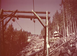
Item is a photograph of the two cables and sets of wooden gates of the chairlift at Grouse Mountain. Tree stumps and fallen trees are visible along the chairlift path, and other buildings are visible along the path on the right.

Beverage Dispensers Union (Locals 676 and 835) Picnic Swedish Park
Part of Hotel, Restaurant and Culinary Employees and Bartenders Union, Local 40 fonds
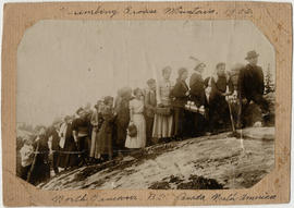
Panoramic view group portrait showing the "Lind Bowl"
![[Water system at Burwell Lake]](/uploads/r/null/2/7/9/279dc4809a615465d8340864db760b573ee6165405b7f7f455028d1604266087/71276c87-a294-4c13-9d87-8a3023d1e0fe-PANP66_142.jpg)
[Water system at Burwell Lake]
Part of Major Matthews collection
Item is a panorama print created from negatives Mount N38.1 (left side) and Mount N38.2 (right side).
![[View of Loch Lomond, North Vancouver]](/uploads/r/null/8/b/8bb90984698bbda6bfe936b6043a47b7a9ddee2c1ec428436f4d11e3bcf1cae3/13ae92f3-6ddc-484d-9494-c5bc3e7bae29-A64489_142.jpg)
[View of Loch Lomond, North Vancouver]
Part of Major Matthews collection
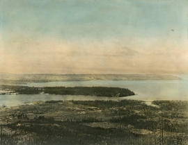
![[Panoramic view of North Vancouver and shoreline]](/uploads/r/null/4/e/4ee696a5cca1c4399f42ab280a1134aff6d0ece1317bf5ba07c79e71586ca9ae/723aa5bf-6f5f-4030-97c8-335c11fb339a-A67014_142.jpg)
[Panoramic view of North Vancouver and shoreline]
Part of Major Matthews collection
Photograph shows Lonsdale Avenue
![[Panoramic view of Burrard Dry Dock, North Vancouver]](/uploads/r/null/9/a/9ada24b0766a77c7dc53375955ec3af0f4838bf6f15ade873bc166e937c39a1b/32298235-e89c-442f-871e-3e5a5f7f939c-A64515_142.jpg)
[Panoramic view of Burrard Dry Dock, North Vancouver]
Part of Major Matthews collection
View shows cargo steam ships under construction, the North Vancouver Ferry and the St. Alice Hotel.
Part of Major Matthews collection
![Profile of pipe-line : Capilano intake to Little Mt. [Mountain] reservoir](/uploads/r/null/f/d/e/fde7fb6226629fad04bbf9be7365df117c8a21327882aba29740dae663d9c8fb/a5da6578-eab7-4510-9aa2-cc05f6ce537d-MAP866_142.jpg)
Profile of pipe-line : Capilano intake to Little Mt. [Mountain] reservoir
Part of City of Vancouver fonds

City of North Vancouver zone map showing "use" and "set-back" restrictions
Part of City of Vancouver Archives technical and cartographic drawing collection
Item is a map showing zoning in the city of North Vancouver. Zones include residential (single-family residences only, semi-detached residences and apartment blocks, hotels, etc.) business (Local shopping and business and buildings of the warehouse class) and industrial districts.

Part of City of Vancouver Archives technical and cartographic drawing collection
Item is an architectural drawing of a Second Narrows crossing, bridging Vancouver and North Vancouver. The drawing consists of an elevation of the bridge, as well as a plan of the bridge and the north and south approaches.

Part of City of Vancouver Archives technical and cartographic drawing collection
Item is a map compiled and drawn by J.S. Matthews, City Archivist showing historic place names of Vancouver and the North Shore and listing some historic Burnaby names. A note in the bottom left hand corner reads: "Memorada. The precise location of "Albert City" is unknown, Narveaz was first; 150 years passed before his name was given to a landmark. His vessel's name "Santa Saturnina" has never been applied to anything at all."
![[Institute Hall] Lynn Valley](/uploads/r/null/9/0/90b2248796151cbd847a92c8428298801a0e25ed6f9ea5b822ebaf83b1ec5d2f/e05679cc-a32d-4a2f-9c35-389f9d7fe656-A02983_142.jpg)
Part of Stuart Thomson fonds


Capilano River and Suspension Bridge

Capilano River and Suspension Bridge

6th Avenue Methodist Church group climbing Grouse Mountain

Canadian Traffic Signal Corporation - Photo of New Signals on Benwicke Avenue
Part of Stuart Thomson fonds

North Vancouver All Black's English Rugby Team
Part of Stuart Thomson fonds

Exterior view of Grouse Mountain Chalet

Exterior view of Grouse Mountain Chalet in winter
Photograph shows 2 people standing outside in the snow.

Exterior view of Grouse Mountain Chalet in winter
Photograph shows a person standing outside in the snow.

Interior of Grouse Mountain Chalet
Photograph shows chairs by the fireplace, mantle and stairs.

Interior of Grouse Mountain Chalet
View of Stanley Park and Point Grey from Grouse Mountain
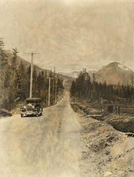
Center Road leading to the Grouse Mountain Highway

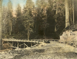
Grouse Mountain Highway under construction
Grouse Mountain Highway from Thunderbird Bridge
Photograph shows 2 men and tractor on bridge.
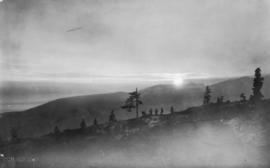
View of sunset and people on Grouse Mountain

Switchback in Grouse Mountain Highway
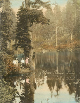
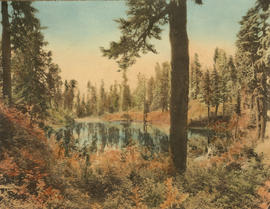
Blue Grouse Lake, Grouse Mt. Park
Photograph shows 4 people standing beside the lake.