![Boundary [Road] and Lougheed [Highway looking] west](/uploads/r/null/f/4/f42768f508beed633758533669d9f58dcfb5781067a28b65ddf2a4b2b4037380/34cd52c1-1770-4437-8b9d-3b37fee5df9f-A42870_142.jpg)
Boundary [Road] and Lougheed [Highway looking] west
- COV-S505-1-: CVA 772-204
- Item
- [between 1980 and 1997]
Part of City of Vancouver fonds
Boundary [Road] and Lougheed [Highway looking] west
Part of City of Vancouver fonds
![Boundary [Road] and Marine [Drive looking] west](/uploads/r/null/c/b/cb63a6d670b696fb60ad4ca4af1d8028e7514095117c09c8dc7c73adf3f4e433/038c784a-0ec0-4038-93ec-13f2affea4a7-A42873_142.jpg)
Boundary [Road] and Marine [Drive looking] west
Part of City of Vancouver fonds
![Burrard [Street] and Broadway [looking] west](/uploads/r/null/8/d/8d82f69d18a3dba5a841db37b38d747e50ff287b5ee43f2661f3ee1d0a395a0c/05eec5e7-c6e1-40e1-a0cd-4a5bc878f802-A42907_142.jpg)
Burrard [Street] and Broadway [looking] west
Part of City of Vancouver fonds
![Burrard [Street] and Broadway [looking] south](/uploads/r/null/e/4/e409e613be42a8dcd09042b9b0b2c08b200259800c8b28f99eba183300c68061/3f273c71-7c0a-40dc-9965-d11d93ee8e58-A42908_142.jpg)
Burrard [Street] and Broadway [looking] south
Part of City of Vancouver fonds
![Burrard [Street] and Nelson [Street looking] north](/uploads/r/null/e/a/ea0345dd2ebd3751c86a8d122aae85240a34e9c9c277eb29bd48a3cf80bace0f/c3b4b31a-95fb-4149-a4e9-a92db65de748-A42938_142.jpg)
Burrard [Street] and Nelson [Street looking] north
Part of City of Vancouver fonds
![Burrard [Street] and Pacific [Street looking] south](/uploads/r/null/8/5/8512454127ec9d760fd8501d30c39c16eaa5afd8701f4724cfcdc5bdba12913e/e723cc0d-3b4a-4f1a-b7b6-d38149a653ea-A42941_142.jpg)
Burrard [Street] and Pacific [Street looking] south
Part of City of Vancouver fonds
Photograph shows the north entrance to the Burrard Bridge
![Burrard [Street] and Smithe [Street looking] north](/uploads/r/null/d/7/d79ed616026dd5aaa227d902f5c8df0a772c7652bbd5cbf77dc93d1d3986ecdc/ed85d84e-c018-4754-aa51-a634c2f058b1-A42952_142.jpg)
Burrard [Street] and Smithe [Street looking] north
Part of City of Vancouver fonds
![Burrard and Smithe [streets looking] east](/uploads/r/null/5/3/53bfa404b30f7f8d2416f805d582f22be26b03a4c15523f41964ba35f97fdaf4/091eaba7-6100-48b6-a246-ef81d70324a9-A42953_142.jpg)
Burrard and Smithe [streets looking] east
Part of City of Vancouver fonds
![Burrard [Street] and 4th [Avenue looking] north](/uploads/r/null/f/b/fb4d86bb6c90768a116bfbc41e14fbcc94fbe6383a7f2728382b04edb692b620/7865584d-d3d7-4c07-a22d-9db651d41c15-A42959_142.jpg)
Burrard [Street] and 4th [Avenue looking] north
Part of City of Vancouver fonds
![Bute and Georgia [Streets looking] east](/uploads/r/null/d/3/d31685c9bcebf23ee5acd00081e75932e9b897e437c1e5a258dacd52106cac6c/68fd75f7-41fc-45f8-b4a3-def36a75c0e0-A42849_142.jpg)
Bute and Georgia [Streets looking] east
Part of City of Vancouver fonds
![Cambie [Street] and 12th [Avenue looking] east](/uploads/r/null/8/9/890ecb4a7f905d06265d5800b7208becc379fd2adb498934b1fc8ef542b57a73/d3093694-4d59-4c8c-86af-b24bd2ccbfb2-A43033_142.jpg)
Cambie [Street] and 12th [Avenue looking] east
Part of City of Vancouver fonds
![Fraser [Street] and Kingsway [looking] west](/uploads/r/null/4/f/4f8943c439a563895f3d05a0cd2c214136c90340eb4e82b3ab28a3b899ff8f26/8605a189-0509-43a6-8a6f-015419b1433d-A43492_142.jpg)
Fraser [Street] and Kingsway [looking] west
Part of City of Vancouver fonds
![Hornby and Robson [Streets looking] west](/uploads/r/null/0/8/08b37de48115f22e2a449b57591d9492e55b600a33c3c8e48c157814fe3f1f8c/e7dd47c2-0b5d-48a8-8840-23311bafe42a-A43870_142.jpg)
Hornby and Robson [Streets looking] west
Part of City of Vancouver fonds
![Granville [Street] and 71st [Avenue] looking north](/uploads/r/null/6/e/6e07d771a2239df9ca6430b1246a1594e68c70c95203e20bab3c36b5900ddf55/6263fe8d-9097-42a9-9c60-3e8794bf740e-A43756_142.jpg)
Granville [Street] and 71st [Avenue] looking north
Part of City of Vancouver fonds
![Cambie and 19th. [Avenue looking] north](/uploads/r/null/a/b/abd4277415b29ead9be2b7cf305a2e37e4018476c8d3013e2aef50537c8aee77/bccd9c16-2fe6-47ab-a699-bad88cfeca2b-A43043_142.jpg)
Cambie and 19th. [Avenue looking] north
Part of City of Vancouver fonds
![[Glen Drive and 12th Avenue looking south]](/uploads/r/null/9/b/9b6494015ee60f546f66548ba74d99351e914510ce8148e2f8865eeae15e8ea2/135ee982-7c9f-45f5-927f-35e4159d0d3d-A44552_142.jpg)
[Glen Drive and 12th Avenue looking south]
Part of City of Vancouver fonds
![Begg [Street] at Terminal [Avenue looking] east](/uploads/r/null/a/f/af0ec1f52dc1a3650d0d86dae593103224a89f3d313d1b555932427d9e05d9e0/92862dc1-0c3d-4eae-92f6-5e939059ee3b-A42789_142.jpg)
Begg [Street] at Terminal [Avenue looking] east
Part of City of Vancouver fonds
Photograph taken underneath the Grandview Viaduct
![Boundary [Road] and 45th [Avenue looking] east](/uploads/r/null/d/8/d85545357d9ce98a48c9f7f97290cbf51f330c66dbbd1f29ca9d95a70977a2f9/515e769d-ad2f-4c29-85b1-18b35ac96fa3-A42893_142.jpg)
Boundary [Road] and 45th [Avenue looking] east
Part of City of Vancouver fonds
![Boundary [Road] and 45th [Avenue looking] north](/uploads/r/null/f/f/ffbc7b6265da109c4888db8527a75abb71a4b262e71aea9fd3570380687a8d21/ffa1006b-0809-4769-82e6-c2c753efa76a-A42890_142.jpg)
Boundary [Road] and 45th [Avenue looking] north
Part of City of Vancouver fonds
![Boundary [Road] and 45th [Avenue looking] south](/uploads/r/null/e/d/ed8bca323b04c26466ed649a5ae031156cdc8fb07a14956206ffe18153f73e2d/2d3eb11d-ed80-4c33-b7ba-cfa351a53bc1-A42891_142.jpg)
Boundary [Road] and 45th [Avenue looking] south
Part of City of Vancouver fonds
![Boundary [Road] and 45th [Avenue looking] west](/uploads/r/null/b/d/bdd08ee937e119a718844a9f50e15d600454f3afd2183feb482f5a93a4641a1b/f75df89b-d28e-4f89-a42b-943c05db13e4-A42892_142.jpg)
Boundary [Road] and 45th [Avenue looking] west
Part of City of Vancouver fonds
![Beach [Avenue] and Thurlow [Street looking] west](/uploads/r/null/2/3/23c699fc5040859c8da92714096b3ea3af61c33e29c1ae655d96ab19b0b4eb89/82cd55d9-0956-49f0-acbf-8170963e11f6-A42770_142.jpg)
Beach [Avenue] and Thurlow [Street looking] west
Part of City of Vancouver fonds
![Beach [Avenue] and Thurlow [Street looking] north](/uploads/r/null/c/4/c4ad54a5b1008db5b8f49947db08d3ed99da796a97f6ee690edaded85cb72df5/70fa2f82-7a1b-4822-898f-7dc3ca465434-A42771_142.jpg)
Beach [Avenue] and Thurlow [Street looking] north
Part of City of Vancouver fonds
![West Boulevard and 45th [Avenue looking] north](/uploads/r/null/c/9/c9ac65d4b4530a8a2f43365fb93aa77ddfc576078bf29acaa0d1139829eacb92/ff913e12-5453-47a3-b340-52637d2e0ae0-A42819_142.jpg)
West Boulevard and 45th [Avenue looking] north
Part of City of Vancouver fonds
![Ash [Street] and Broadway [looking] east](/uploads/r/null/8/3/83c227b223500f5814846e8a3704a1c180610f620d57ec1ce1716fd1f64ee693/e8b9d360-bf17-470d-b41b-9dbc278006b5-A42762_142.jpg)
Ash [Street] and Broadway [looking] east
Part of City of Vancouver fonds
![Ash [Street] and Broadway [looking] north](/uploads/r/null/9/4/94350f66137c908523de406afda47bafbc5932a30ece1189af4e9b33e7900dbd/23953fc3-d2ce-44b3-aba7-15abea0bd7e8-A42763_142.jpg)
Ash [Street] and Broadway [looking] north
Part of City of Vancouver fonds
![Marine and Angus[Drives] looking west](/uploads/r/null/a/c/ac60f269a4347eebf325e81d575fc365b50ce06f2c00315936965cb72257639a/0d30b890-81a0-4270-bd38-680443197527-A44093_142.jpg)
Marine and Angus[Drives] looking west
Part of City of Vancouver fonds
![Beach [Avenue] and Thurlow [Street looking] east](/uploads/r/null/e/5/e5b61776b0dd209e0887c02fcdeeb1c32e0ebac285911f6d3242d0c27c88493c/2d3c6834-2720-4958-8010-c2abde712334-A42769_142.jpg)
Beach [Avenue] and Thurlow [Street looking] east
Part of City of Vancouver fonds
Photograph shows the north end of the Burrard Bridge over Beach Avenue
![West Boulevard and 45th [Avenue looking] south](/uploads/r/null/c/5/c5d6bd0529b7bd91919fd2eba5ffd835473f6d76ebcd49041bac8071be049efd/65989e2d-8a5b-4f42-89b0-e118df669a11-A42820_142.jpg)
West Boulevard and 45th [Avenue looking] south
Part of City of Vancouver fonds
![2409 Main Street [F.W. Woolworth Co.]](/uploads/r/null/5/c/1/5c182ddd1b224ad36b6d4f9a7583c1e06c1d4e9285d4a9894429c399380c5bfe/1998be35-c0d5-44ef-9e62-48d7f21e39b1-CVA332-25_142.jpg)
2409 Main Street [F.W. Woolworth Co.]
Part of City of Vancouver fonds
Photograph shows street banners.
![2409 Main Street [F.W. Woolworth Co.]](/uploads/r/null/f/d/f/fdfdaab03f8fc2d005116b0dd3377d6a2c57a4c3edd0de77d2ca93074889c65a/df886338-9dc6-4d85-997e-68d6b0aed5c9-CVA332-26_142.jpg)
2409 Main Street [F.W. Woolworth Co.]
Part of City of Vancouver fonds
![Broadway and Stephens [Street looking] north](/uploads/r/null/d/4/d46142a02179e38605f87a167da07f99d0df8dd532bbf8256b7bd125e0edaa78/8ae2d194-935a-40b8-bfe1-10cee6628b94-A42902_142.jpg)
Broadway and Stephens [Street looking] north
Part of City of Vancouver fonds
![Broadway and Stephens [Street looking] east](/uploads/r/null/6/6/66f2fe9300f0151a31d835f1655054e900f11b910c1a9137c52cb546a2806227/9499abbc-eeb3-44ab-96b7-70fdcda4dbd8-A42904_142.jpg)
Broadway and Stephens [Street looking] east
Part of City of Vancouver fonds
![Broadway and Stephens [Street looking] west](/uploads/r/null/7/a/7a821381f67fc35c5fcff7717196ce068b06bea761526ead6fdbc89b3c4ff5b6/7b591056-0d17-4374-a3f7-20a62a88279a-A42905_142.jpg)
Broadway and Stephens [Street looking] west
Part of City of Vancouver fonds

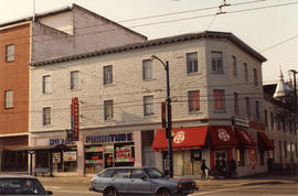
Part of City of Vancouver fonds
Photograph shows Royal Furniture and Mt. Pleasant Credit Union.
![Cambie [Street] and 59th [Avenue looking] east](/uploads/r/null/a/c/ac8e28e6034d133bc4a84588a39dfa83ebcfd0ad8db7fd5994f4e20b10d416fa/b63f838a-6273-46fa-b2ab-6e27bce481fb-A43067_142.jpg)
Cambie [Street] and 59th [Avenue looking] east
Part of City of Vancouver fonds
![Burrard [Street] and Helmcken [Street looking] north](/uploads/r/null/5/c/5cfa1a41bcc74afb6df8f3919cf0d4533d47c32ec08966325a1e91fe184cba44/1b8f0c46-914a-4d7a-acde-1b2134f79514-A42932_142.jpg)
Burrard [Street] and Helmcken [Street looking] north
Part of City of Vancouver fonds
Photograph shows part of St. Paul's Hospital
![Burrard [Street] and Helmcken [Street looking] south](/uploads/r/null/e/2/e2c9bc63927c2c6881d91b3b266171a6ccf0ad093770d55cdb596c80e8df8b60/0e79b69d-6bbf-49a0-98ad-dc845002d75c-A42933_142.jpg)
Burrard [Street] and Helmcken [Street looking] south
Part of City of Vancouver fonds
Photograph shows the Burrard Motor Inn
![Burrard [Street] and Hastings [Street looking] north](/uploads/r/null/0/5/057c4906499227d7427f6b49eca0118e0f7a4e55b1a079da5a24333f79d02455/a23eca92-ad71-43c9-a803-ba566536c01d-A42931_142.jpg)
Burrard [Street] and Hastings [Street looking] north
Part of City of Vancouver fonds
![Burrard [Street] and Nelson [Street looking] south](/uploads/r/null/a/e/aed0d6f7d8e56a92a859556f5b17d1f9496d8191504fb027b5c5282a00c26a16/fedb0652-60ca-4caa-962a-96d52272d74a-A42937_142.jpg)
Burrard [Street] and Nelson [Street looking] south
Part of City of Vancouver fonds
![Cassiar [Street] and [Highway] 401 [3 of 7]](/uploads/r/null/6/5/9/6597641edc353946d6f7c3d8bb4fef779568944b08b8257bdd559dd15f0fa732/ad6b3c4f-fead-49c1-9038-6239ccda4c53-2019-103.0539_142.jpg)
Cassiar [Street] and [Highway] 401 [3 of 7]
Part of City of Vancouver fonds
![Commercial [Drive] and [Broadway intersection, 1 of 4]](/uploads/r/null/8/1/3/81394f6850869878a70e81766598cbc9adabf70773468f78cf6449d819c54eb5/32ddd3e9-e2cf-4809-abaf-59fa559a17bd-2019-103.0018_142.jpg)
Commercial [Drive] and [Broadway intersection, 1 of 4]
Part of City of Vancouver fonds
![Victoria [Drive] and 33rd [Avenue intersection, 1 of 4]](/uploads/r/null/1/3/4/134bbe0dc31384c080db3e46359a17082991cc587b3ac40af2aad7df5dd2e74c/1fbf7c1b-ce17-462a-9c19-7811ce6db87a-2019-103.0027_142.jpg)
Victoria [Drive] and 33rd [Avenue intersection, 1 of 4]
Part of City of Vancouver fonds
![Victoria [Drive] and 33rd [Avenue intersection, 2 of 4]](/uploads/r/null/0/e/6/0e659a0047971867c90c53854afdcb169a6c5200ba0f4d76ba28d4207a653cf0/f8ca2cd3-a212-436d-b476-85370654bc99-2019-103.0028_142.jpg)
Victoria [Drive] and 33rd [Avenue intersection, 2 of 4]
Part of City of Vancouver fonds
![Victoria [Drive] and 54th [Avenue]/Argyle [Drive intersection, 2 of 8]](/uploads/r/null/e/9/f/e9f333ec479cfa33b7be24ae844837467245543d7aeeb324b27dc93fcd29c866/1368a2f6-97c3-490d-add5-11352829e88c-2019-103.0049_142.jpg)
Victoria [Drive] and 54th [Avenue]/Argyle [Drive intersection, 2 of 8]
Part of City of Vancouver fonds
![RLS [Downtown street]](/uploads/r/null/b/9/a/b9a32227c48425cefdcc288cbf37aa631d3e9bc5d968de7d113f57551211d83d/737fe8d1-c17e-4eb2-86b2-24ed62bfe701-2019-103.0060_142.jpg)
Part of City of Vancouver fonds
![RLS [Cars on side street, 2 of 2]](/uploads/r/null/3/1/d/31d266c99981ea03ba885de387fa5c8db128ba15ce3983a781f19ce296d547be/4fec0eb5-524e-46d6-98b8-12ec557b55dd-2019-103.0064_142.jpg)
RLS [Cars on side street, 2 of 2]
Part of City of Vancouver fonds
![Oak [Street] and 12th [Avenue intersection, 1 of 4]](/uploads/r/null/7/5/6/756fcab838ddb70f9c8cc25680cfb7f367acacc5fe3dd748e4f4480324aa11a0/469601e7-8ad9-4d72-a971-864d91bcba8b-2019-103.0266_142.jpg)
Oak [Street] and 12th [Avenue intersection, 1 of 4]
Part of City of Vancouver fonds
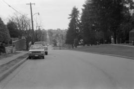
Looking west on East 15th Ave. toward Knight St.
Photograph shows depression in 15th Avenue where China Creek once flowed. To the right is Clark Park. Additional descriptive information on back of print.