
Dial map of Greater Vancouver and suburbs

Dial map of Greater Vancouver and suburbs

Dial map of Greater Vancouver

Map of Vancouver with street directory indicated by dial : map cover and street index
Map of Vancouver with street directory indicated by dial : map
Map of Vancouver with street directory indicated by dial
Map of Vancouver with street directory indicated by dial
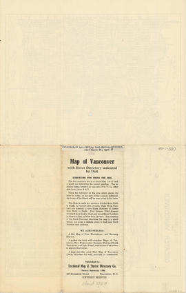
Map of Vancouver with street directory indicated by dial : Map cover
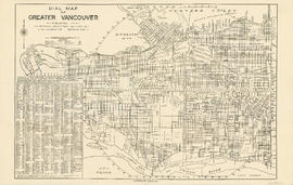
Dial map of Greater Vancouver
Map of Vancouver with street directory indicated by dial
Map of Vancouver with street directory indicated by dial
Sectional map and street directory of Vancouver : Dial map of the city of Vancouver including adjacent municipalities
Sectional map and street directory of Vancouver : Dial map of the city of Vancouver including adjacent municipalities
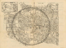
Dial map of the city of Vancouver with list of apartments
Dial map of the city of Vancouver with list of apartments
Dial map of the city of Vancouver including the adjacent municipalities
Dial map of the city of Vancouver including the adjacent municipalities

Where the 19th century Townsite meets the 20th century : Project 200
![[View of] Hastings St. looking east from Hornby](/uploads/r/null/0/4/0470bb9219d126f8bcb407384a6c7238af2d2ff2ec3164ebef90189a224d525d/5d8e50db-7c1a-48a8-9ddf-e12cb8356c36-A09734_142.jpg)
[View of] Hastings St. looking east from Hornby
![[View of Granville Street and 37th from the 5200 block, Shaughnessy]](/uploads/r/null/4/7/474b6dcf8ef35087ef9b76000cfbe43c23bd03fbd291f22d3ab8f42be1c46994/34a9c2f5-a821-4376-85e7-c727125ccbbb-A63184_142.jpg)
[View of Granville Street and 37th from the 5200 block, Shaughnessy]

City of Vancouver : east half
![[Cordova Street looking west from Carrall Street]](/uploads/r/null/2/a/3/2a3d21e3af3e2e85d0cf2207073f1924b9cb97f602b6dd55da2a4faee2693230/9b8051d7-2e39-42ec-b77b-929e8483001a-CVA371-1216_142.jpg)
[Cordova Street looking west from Carrall Street]
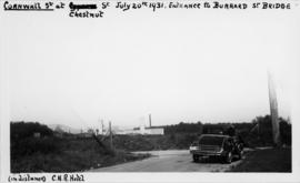
[View of Cornwall and Chestnut Streets, looking east towards partially constructed Burrard Street Bridge]
![[View of Cedar Street (Burrard Street), looking south from 1st Avenue]](/uploads/r/null/5/4/6/546bde6574cf2d5e2d523addd9591e1710627187bd04c3d93cb181a8630c2230/a0010462-bb2d-4682-af2b-e493c71a1bdd-CVA371-817_142.jpg)
[View of Cedar Street (Burrard Street), looking south from 1st Avenue]
![[View of Cedar Street (Burrard Street), looking north from 1st Avenue]](/uploads/r/null/9/5/1/951361df52bc39caa119f27dbb826caa9f8321d69bffb9d534bf12ba32aa9705/36b8f243-7cb9-4ced-b859-5c83a7f4b85b-CVA371-816_142.jpg)
[View of Cedar Street (Burrard Street), looking north from 1st Avenue]
![[View of Cornwall and Cypress Streets near entrance to Burrard Street Bridge]](/uploads/r/null/8/6/d/86dac76ad8cb724cd7224e11a833da97224b6b85e5d0a9820f2a72347779b95d/28b56d29-93a3-4728-8ca0-db35bb4c412d-CVA371-815_142.jpg)
[View of Cornwall and Cypress Streets near entrance to Burrard Street Bridge]
![[View of Kingsway looking east from Slocan Street]](/uploads/r/null/5/3/8/538bef10d8f9525379c886d8f11cbe174269af436656e5528912805ae68083a6/a48926da-86d5-47c9-b715-e358d64c89db-CVA371-813_142.jpg)
[View of Kingsway looking east from Slocan Street]

Cordova Street, Vancouver, B.C.
![[Panoramic view looking north from the Hotel Vancouver]](/uploads/r/null/d/0/3/d032ae1a08ec1b68763941336f6a07708bf678235ae8cdf506cbbdc3fb10451d/98ea51ff-abce-48a9-9401-16834b8ba6a4-VanScP143_142.jpg)
[Panoramic view looking north from the Hotel Vancouver]
Wrigley's new revised map of Vancouver
Wrigley's new revised map of Vancouver
![George Noble [client] [safety zone (pedestrian island) for street car patrons on Hastings Street]](/uploads/r/null/8/d/2/8d28570481c90c92a7a30e0cd5e7f66e555e50bb9923076966928acaeb36fbcd/495b4cee-f831-4620-a782-ab91f9783c27-CVA99-2619_142.jpg)
George Noble [client] [safety zone (pedestrian island) for street car patrons on Hastings Street]
![Christ Church [Burrard and Georgia]](/uploads/r/null/b/b/6/bb6d9aaf58788d31754ba4360f73df1562b183e2d076ea10d5d2edf0e30e06ec/53218777-9467-4721-a1ca-41efc22c872c-CVA99-1438_142.jpg)
Christ Church [Burrard and Georgia]
![[The intersection of West 41st Avenue and Yew Street looking east]](/uploads/r/null/0/3/03707592446d31ae3603fd5f8ad9f7be48b11f239287ae850daef086e0527eb4/e5015cca-b625-4e79-bccc-89c2f38d62e7-A72373_142.jpg)
[The intersection of West 41st Avenue and Yew Street looking east]
![[The intersection of West Boulevard and West 41st Avenue]](/uploads/r/null/1/f/1faef7a9c98027c1b32378f0fb73ae3d253e2295d048b120bef9bd0cebace7d4/6b74ae54-437a-4c43-a0db-4d1a73c95ab0-A72372_142.jpg)
[The intersection of West Boulevard and West 41st Avenue]
![[Looking east along West 41st Avenue from East Boulevard]](/uploads/r/null/f/4/f45df961246ce689a05d6ee05d5c8b10ad1370a7184f1476eff37a7354471997/d8f7ac28-5f53-4b95-8fd8-591ffc652e53-A72371_142.jpg)
[Looking east along West 41st Avenue from East Boulevard]
![[Looking north along East Boulevard from West 41st Avenue]](/uploads/r/null/3/3/33d1af91875444f1a42b00570aeaccede9cbcd24aa2b1b7472234fa6b68c0cee/b9a8c1c9-553f-40a0-8fdb-ff2a184e97be-A72370_142.jpg)
[Looking north along East Boulevard from West 41st Avenue]
![[Looking south on West Boulevard from the 5600 Block]](/uploads/r/null/4/a/4a01fab7e369be74da8a846e1a4fa4542f1cc7c7c1b6574f6004d0852b5c636a/b8a74e69-5b5d-4835-a287-d0c81e59a1f1-A72366_142.jpg)
[Looking south on West Boulevard from the 5600 Block]
![[The intersection of West 41st Avenue and West Boulevard]](/uploads/r/null/2/2/22a76905ef63933c1aa44846fb7e1d99bdff06c62e24598ffbec7542cb7458ac/73805b10-0897-461f-9ccf-7f0916dc2e0d-A72365_142.jpg)
[The intersection of West 41st Avenue and West Boulevard]
![[The intersection of West 41st Avenue and East Boulevard]](/uploads/r/null/3/f/3f8745272c6df898bfb307a131cd05f7d6771cc112277c0363d88bc261d0f497/67da1a2b-6e85-4bb8-b951-8aec15f9ff63-A72364_142.jpg)
[The intersection of West 41st Avenue and East Boulevard]
![[Canadian Pacific Railway Pier 'D' fire]](/uploads/r/null/c/f/cf438fa385ddd1f4fef863a0a40f12979362af88e06b942c6a4b9d7457762ea4/56e93e6a-0ceb-4772-b267-0e46f31d9d21-A09130_142.jpg)
[Canadian Pacific Railway Pier 'D' fire]
Industry : quality of street
Industry : quality of street
Contour plan of a portion of the City of Vancouver

City of Vancouver
![Unidentified street in Point Grey [4700 block of Belmont Avenue]](/uploads/r/null/e/2/f/e2fcb9deb7c5796ad6bb91a89e1c9c6b545ad7eabf824d20dd91bb2a9b851015/33eae8b7-c304-4261-9102-5140636a4ea3-CVA798-3_142.jpg)
Unidentified street in Point Grey [4700 block of Belmont Avenue]
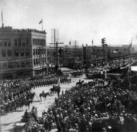
[View of the Duke and Duchess of Cornwall and York arriving at the reception outside the Courthouse on Hastings and Cambie Streets]

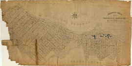
Town-site of Hastings
![[Granville Street looking north from about Dunsmuir Street]](/uploads/r/null/9/7/97ead2853467a47e096b6533ca8b64418e751d5859d0c9f0c0e4cf01aac168ca/13f76c26-8671-4abe-a36c-5d7a92e7feb4-A37343_142.jpg)
[Granville Street looking north from about Dunsmuir Street]
![[Panoramic view of Vancouver looking east, south and west from the Post Office tower]](/uploads/r/null/3/4/3440da1e98108d2cb1b9e915b9d5784f1ce26f037ac1f6597fb6f283670ef6fa/d87fd6ce-c19b-43e2-af52-69db5b1e0d1e-A63166_142.jpg)
[Panoramic view of Vancouver looking east, south and west from the Post Office tower]
![[Panoramic view of downtown, Vancouver from Granville and Hastings Streets]](/uploads/r/null/2/1/6/216cf899114250d1b31f38600b649f3b49bbd0c5882c6b5a6a9519d124d69cd5/addbb40b-0fc9-430e-8ebb-76d531606378-PANP92_142.jpg)
[Panoramic view of downtown, Vancouver from Granville and Hastings Streets]
![[Panoramic view of downtown, Vancouver from Granville and Hastings Streets]](/uploads/r/null/b/6/b/b6b44d6ac0fb2fd61907ae9bad2a5792f8dce904b90fa1406d9c99ea2d36ee94/a76ddde8-2b68-4786-82cb-14470e682cd1-PANP92_142.jpg)
[Panoramic view of downtown, Vancouver from Granville and Hastings Streets]

Vancouver, B.C. "The livest and most beautifully located city in Canada"
![[Northern and eastern view of] Vancouver, B.C. [showing Burrard Inlet, Downtown, False Creek and ...](/uploads/r/null/a/d/ad499a709643b866df0dd06ee0db3a33d39d0fae463dc917d66f4f31c3dac3ad/05fca819-4e81-4708-982c-e3af142f77cb-A63163_142.jpg)
[Northern and eastern view of] Vancouver, B.C. [showing Burrard Inlet, Downtown, False Creek and Yaletown]
![[View of the 1900 Block and 2000 Block of Nelson Street]](/uploads/r/null/d/5/d58b220b2f356143bdd1652a781ab12a6ce66d5858da8ca763e64de2e942d685/71b1f0ef-346b-41e5-bfc5-1f4811088cec-A63162_142.jpg)
[View of the 1900 Block and 2000 Block of Nelson Street]
![[View looking north from Granville Street and 14th Avenue]](/uploads/r/null/d/6/d69db2c2bb4b88fa530d16ebe363cdc169c4295d1b2970a2b748f72ca47a2b61/4074e348-0383-47fb-962c-715c80f990e4-A63891_142.jpg)
[View looking north from Granville Street and 14th Avenue]
![[View of Downtown looking north from Burrard Street near Smithe Street]](/uploads/r/null/5/5/55d8edafe09d551a1b347d53f583ba1f176584e2e5179909aed5e5d271bdf50e/49a94ff1-b4b2-467a-b48f-950b069fbb57-A63342_142.jpg)
[View of Downtown looking north from Burrard Street near Smithe Street]